610 résultats
Very Good Turkish Original manuscript map of Alexandria Port and its immediate hinterland. Folio. (33 x 41 cm). In Turkish (Modern). Folded. No scale. The manuscript shows Alexandria Port and the Palace of the King Farouk of Egypt, customs shores, ports and harbors, locations of the British ships, radio station, location of SS Ramlah, strait, Great Pass (?), waterfront for the lumber ships, sea current zones and probably entrance and exit routes etc. A very detailed map, decorated with ships. Some repairs with tape, tears, foxing and stains. Overall a good copy.
1983LFA-126740148N° 188 (Mars 1984) : 86 pages, format 215 x 285 mm, illustré, broché couverture couleurs, bon état
1985LFA-126740151N° 200 (Mars 1985) : 86 pages, format 215 x 285 mm, illustré, broché couverture couleurs, bon état
1995LFA-126746921N° 314 (Juillet-août 1995) : revue de 94 pages, format 215 x 285 mm, illustrée, brochée couverture couleurs, bon état
2009LFA-126747123N° 467 (Juin 2009) : revue de 82 pages, format 215 x 285 mm, illustrée, brochée couverture couleurs, bon état
2010LFA-126716066N° 342 (Novembre-décembre 2010) 120 pages, format 215 x 285 mm, illustré, broché couverture couleurs, bon état
1994LFA-126711213N° de Novembre 1994 : Revue mensuelle fondée en 1856 par des Pères de la Compagnie de Jésus (Jésuites) de 144 pages, format 155 x 235 mm, brochée
2011LFA-126720428Revue de 114 pages, format 220 x 285 mm, illustrée, brochée couverture couleurs, bon état
Very Good Turkish, Ottoman (1500-1928) Original color map on cloth. A little foxing on cloth. Very good. Folded. Oblong atlas folio. (50 x 67 cm). In Ottoman script. Scale: 1/300.000. Map of Ottoman Kayseri printed in its period. No publisher and map-maker. Physical geography of Kayseri city and its around. It shows Kayseri, Sultan Sazligi, mountains and hills, Malatya borders, etc.
Very Good Turkish, Ottoman (1500-1928) Original color map on cloth. Oblong eephant folio. (64 x 573 cm). Toponyms in Ottoman script. [MAP of BALKANS] Filibe [Plovdiv]. A very detailed map. Shows Plovdiv and mountains, rivers around it. Extremely rare.
Very Good Turkish, Ottoman (1500-1928) Original color map. Folded. Oblong atlas folio. (50 x 60 cm). In Ottoman script. [MAP of EAST ANATOLIA] Malatya - Divrigi, Mancinik, Adiyaman, Harput. Shows Malatya, Adiyaman and Kharpout region; Firat River (Euphrates), Yazi Düzü, Erguvan etc. Scale: 1/200.000. This is one the serie of the Bonn projection maps which are the first map series in modern techniques in Turkey and the Ottoman Empire. In order to produce these maps covering Turkish territory, Reconnaissance Branch was incorporated into The Mapping Commission. The maps were produced in the datum based on the latitude and longitude of Ayasofya Mosque in equal area Bonn Projection. The field works for the 123 sheets covering the country were conducted by 76 staff. The production was completed in 18 years starting from east west. Field works continued without stopping except in years 1914 and 1920. This map series called also reconnaissance maps contributed a lot to producing 1:25.000 scale maps. Hegira: 1332 = Gregorian: 1916. Not description on map-maker. According to Türkezer & Çobanoglu: History of Mapping in Turkey-1:200.000 Scale Maps, cartographer of this map is Kambay, Cemal.
1995LFA-126746689N° 14 (Septembre 1995) : revue de 66 pages, format 215 x 285 mm, illustrée, brochée couverture couleurs, bon état
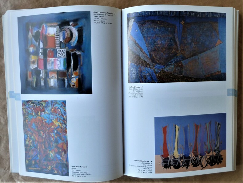
200216393Paris Association du Salon D'Automne 2002 1 Un très fort volume broché de format in 8° de 504 pp. sur papier couché; entièrement illustré; couverture à rabats. Artistes de Macédine; Serbie; Taïwan; artistes Chinois; Coréens... Peinture. Sculpture. Photographie. Gravure. Mobilier. Arts Décoratifs. Mosaïque; plusieurs centaines de reproductions d'oeuvres en couleurs le plus souvent.
1994LFA-12673157281e Fascicule (Année 1994) : 279 pages, format 150 x 235 mm, broché, illustré, bon état
1959LFA-126719852Revue de 64 pages, format 190 x 260 mm, illustrée, brochée couverture couleurs, bon état
1976LFA-126738301Revue trimestrielle de 68 pages, format 155 x 240 mm, illustrée, brochée, bon état
Very Good Turkish, Ottoman (1500-1928) Original color map. Folded. Oblong atlas folio. (50 x 60 cm). In Ottoman script. Shows Southeastern parts of Asia Minor and Syria; Siverek, Sard (Iraq) and Ras Al-Ayn (Rasulayn - Resualyn) in Syria. Hegira: 1333 = Gregorian: 1917. Not description on map-maker. Scale: 1: 200.000. This is one the serie of the Bonn projection maps which are the first map series in modern techniques in Turkey and the Ottoman Empire. In order to produce these maps covering Turkish territory, Reconnaissance Branch was incorporated into The Mapping Commission. The maps were produced in the datum based on the latitude and longitude of Ayasofya Mosque in equal area Bonn Projection. The field works for the 123 sheets covering the country were conducted by 76 staff. The production was completed in 18 years starting from east west. Field works continued without stopping except in years 1914 and 1920. This map series called also reconnaissance maps contributed a lot to producing 1:25.000 scale maps. According to Türkezer & Çobanoglu: History of Mapping in Turkey-1:200.000 Scale Maps, last cartographer of Diyarbakir regio is M. Sait Malatyali. No his biographic material and info in 'Savaslarda Haritacilar'. Rare.
This contemporary report investigated the impact of the conflicts that took place in the Balkan States in 1912 and 1913 when Greece, Serbia, Montenegro and Bulgaria declared war upon the Ottoman Empire and defeated it . In 1913 the Second Balkan War began when Bulgaria, dissatisfied with its loss of Macedonia, attacked its former Balkan League allies. The Balkan Wars were marked by ethnic cleansing with all parties being responsible for grave atrocities against civilians which were documented in this report.[X],418p. Plate,tables mapd. Copy neat and complete with plates and fold-out maps. Library marks including book plate,cover slightly shelf worn, else every good. Ex-Library
1993LFA-126739873N° 101 (Juin 1993) 66 pages, format 220 x 295 mm, illustré, broché couverture couleurs, bon état
018786[Philippe Briet, Parallela geographiae veteris et novae] Diocèses Thraciae daciae et macedoniae juxta notitiam imperii - Grèce, Macédoine Gravure originale, 1649, environ 240*170mm. Gravure tirée de l'ouvrage du savant jésuite Philippe Briet (1601-1668) publié en 1648-1649. Texte au dos. [436]
018790[Philippe Briet, Parallela geographiae veteris et novae] Macedonia, Thessalia, Epirus - Macédoine, Thessalie, Epire. Grèce. Gravure originale, 1649, environ 240*170mm. Gravure tirée de l'ouvrage du savant jésuite Philippe Briet (1601-1668) publié en 1648-1649. Texte au dos. [436]
018797[Philippe Briet, Parallela geographiae veteris et novae] La Macédoine et l'Albanie. Gravure originale, 1649, environ 240*170mm. Gravure tirée de l'ouvrage du savant jésuite Philippe Briet (1601-1668) publié en 1648-1649. Texte au dos. [436]
68695Europe. Revue littéraire mensuelle, 55e année, n°573, janvier 1977, in 8° broché, 247 pages.
68690Europe. Revue littéraire mensuelle, 56e année, n°588, avril 1978, in 8° broché, 251 pages ; couverture illustrée.
Very Good Turkish, Ottoman (1500-1928) Original color map. 50x60 cm. In Ottoman script. Scale: 1/200000. Ottoman map of Eastern Anatolia. Bargiri, Hoy, Baskal'a, Malazgird. It shows Lake Erçek located on the east of Lake Van which is an endorheic salt lake in Van Province in eastern Turkey, about 30 kilometres; on north side, Bargiri place where the oldest district of Van city; on east, Turkish and Azerbaijani and Iranian borders and Hoy city of the West Azerbaijan; and on west, map shows Malazgird [Malazgirt]. This is one the serie of the Bonn projection maps which are the first map series in modern techniques in Turkey and the Ottoman Empire. In order to produce these maps covering Turkish territory, Reconnaissance Branch was incorporated into The Mapping Commission. The maps were produced in the datum based on the latitude and longitude of Ayasofya Mosque in equal area Bonn Projection. The field works for the 123 sheets covering the country were conducted by 76 staff. The production was completed in 18 years starting from east west. Field works continued without stopping except in years 1914 and 1920. This map series called also reconnaissance maps contributed a lot to producing 1:25.000 scale maps.