610 résultats
Biblioteca di Cultura Storica, XVIII. Seconda edizione.<BR>In 8°; pp. 344 con alcune tavole in nero fuori testo e 1 carta ripiegata; brossura editoriale; cucito.<BR>Condizioni molto buone, intonso (segnaliamo forte ingiallitura delle pagine dovuta alla qualità della carta).
EINAUDI 1944 XII - 345 PP. “FONDO DI MAGAZZINO: RESIDUO DI ADESIVO DELL'ACETATO AI CONTROPIATTI SEGNI DEL TEMPO, INGIALLIMENTO DELLE PAGINE, TUTTE LE PAGINE ANCORA DA PARIRE, LETTERALMENTE INTONSO”<br/>
Mm 155x245 Collana "Saggi" - Volume nella sua brossura originale, x-312 pagine con illustrazioni e cartine in nero fuori testo. Opera in ottime condizioni. Spedizione in 24 ore dalla conferma dell'ordine.
9389Vers 1917. Album 19 x 25 cm avec environ 120 tirages photographiques.
PARIS, Les Etincelles -1930 - In-8 broché - 2 Cartes dépiantes HT - 349 pages - Propre.y
2144PARIS, Les Etincelles -1930 - In-8 broché - 2 Cartes dépiantes HT - 349 pages - Propre.y
Very Good English Paperback. Roy. 8vo. (24 x 17 cm). In Macedonian with a short French summary. 175-180 pp. Addition to the studying of the stylistic and expressive characteristics of the Macedonian folk proverbs (summary).= Prilog kon prouchuvacheto na stilsko-izraznite karakteristiki na Makedonskite narodni poslovitchi i pogovorki. [SIGNED COPY]. [Separatum from Makedonski Folklor = Le Folklore Macedonien, Godina II, Epoj 3-4]. Signed and inscribed by Sazdov to Turkish folklorist Tahir Alangu, (1915-1973). Tome Simon Sazdov, (1934-) is a Yugoslav humanist educator.
12004Paris, Editions Klincksieck, avril 1978. Grand in-8 broché vert, 615 à 731 p. Illustrations. Sommaire : Aigeai, site des tombes royales de la Macédoine antique - Découverte et nature de l'art celtique ancien - La découverte du premier temple mède dans la région d'Ecbatane - Trente années de recherches sur les manuscrits de la mer Morte... Très bon état. Publication trimestrielle.
12009Paris, Diffusion De Boccard, juillet 1986. Grand in-8 broché vert, 547 à 884 p. Illustrations. Sommaire : Mécénat royal et princier au Moyen Age - Les origines de la langue grecque - Thasos et la Macédoine... Très bon état. Publication trimestrielle.
17540047921754 Paris, Gandouin, 1754. Trois volumes in-quarto (203 X 259 mm) veau fauve marbré, dos cinq nerfs, caissons dorés ornés, pièces de titre et de tomaison, coupes ornées, tranches rouges (reliure de l’époque). Tome I : (3) ff. de faux-titre, titre et privilège, X pages de préface, XLVIII pages, 421 pages, (1) page et (1) f. d'errata, 51 planches - Tome II : (2) ff. de faux-titre et titre, IX-477 pages, (1) f. d'errata, 22 planches - Tome III : (2) ff. de faux-titre et titre, VII-384 pages, (3) ff. d'avis au relieur et d'errata, 40 planches. Ex-libris «L'abbé d'Auberjon » collé sur le premier contreplat des deux premiers volumes et signature autographe «D'Auberjon » à l'encre brune en marge du feuillet de titre des trois tomes. Petites restaurations aux coupes, coiffes et coins.
New French Paperback. Roy. 8vo. (24 x 17 cm). In French. 222 p. I. Introduction Concepts, goals, methods The location General remarks II. The background to the tension and the komitadji phenomenon Conflict types - general overview The escalation of the conflicts Some temporal and spatial patterns of ceta activity Ceta types and their origins The social background and functions of the revolutionary organizations Financial sources Methods of rule III. Violence in Skopje Sanjak Everyday violence The practice of destabilization - other forms of violence IV. Conflict types in Prizren Sanjak General tendenciesTraditional banditry - weakening central power Banditism vs. the state authorities The state treatment of Banditism - a successful solution? Violence as an alternative source of income for Ottoman state officials Conflicts indirectly generated by the competition between the PowersThe case of the Bogoslovie in Prizren (1899-1900) Protests against the opening of new consulates and trade agencies Actions against sacred places during Christian festivals The Albanian village vs. the town Conflicts stemming from border positions V. Local strategies of coexistence and survival, the politics of neighbouring states and the attempts of the Ottoman government and Great Powers to restore peace Scratching the surface: exit strategies - Symptoms of economic breakdown or of collapsing public security? The macroeconomic situation before 1903 and attempts at reform Prevailing agrarian (social) problems after 1903 The response To the challenge I: The central government and local society The ceta problem reloaded Community-level response to the changes II: The strategy of the Serbs in Macedonia Strategies of intimidation and strategies of survival VI. Epilogue Notes in the margin: the limits to Muslim-Christian cooperation The new order Bibliography Index.
1996100137622Center for the Study of Language and Inf 1996 392 pages 15 27x2 34x22 89cm. 1996. Broché. 392 pages.
19951220506PN. New. 1995. Reprint Edition. Soft Cover. Date is copyright date; this is a later reprint edition . PN paperback
1995279325PN. New. 1995. Soft Cover. Date is original print. This is a reprint edition . PN paperback
Ex-library copy with usual stamps, call numbers and pocket. Minor shelfwear. ; Deals with the development of the Macedonian State and the struggle for survival as well as the Reign of Philip the Second. Includes 10 maps, 3 plates. ; Volume 2 Only; 780 pages
Waviness to about 3-4 pages (moisture? ). Else VG. ; In this single-volume history, R. Malcolm Errington provides a modern account of the political and social framework of ancient Macedon. He places particular emphasis on the structure of the Macedonian state and its functioning in different stages of historical development from the sixth to the second century B. C. Errington's main emphasis is not on the biographies of the great kings but rather on the flexible political interplay between king, nobility, and people; on the growth of cities and their political function within the state; and on the development of the army as a motor of military, social, and political change. ; Hellenistic Culture and Society, 5; 320 pages
Very Good Turkish Original color map. 52x65 cm. In Turkish. Scale: 1: 800,000. Showing shores from Latakia to Haifa; Lebanon , Beyrouth, North Palestine, Syria, Saudi Arabia and borders, Orontes river, deserts. [TURKISH MAP of BEYROUTH, DAMASCUS, JORDAN] Sam, Beyrouth, Lebanon, Jordan.
Very Good English Original b/w portolan chart. Folded. A little foxing and some pencil markings and notes in Ottoman script in its period. Oblong double elephant folio. (70 x 102 cm). In English. Bosphorus to Kerempeh from the Russian survey of 1834 with additions and corrections by Commander W. J. L. Wharton., R. N. 1872-80. It's written 'London published according to Act of Parliament at the Hydrographic Office of the Admiralty Jare. 16th 1854. Also shows Killa Bay (Shile Bay) from a survey by Lieut. Comm. W. R. Pristen and the midshipmen of H. M. S. Royal Sovereign, 1920. Topography partly from a Turkish map. Up side of map, engraved a view from sea of entrance of the Bosphorus, Rumili (sic. Rumeli) Lighthouse and environment with several hills. And also shows Amastra (Ancient Amastris) from Russian surveys, 1834-41; Kosku Bay from a surbey by Capt. Spratt R. N. 1854; and Sungul Bay (Zonguldak) from the Heraclee Companys plans to 1915. A rare navigation chart.
Very Good Turkish, Ottoman (1500-1928) Original map of Kars Fortress. Oblong: 45x57 cm. In Ottoman script. Scale: 1/21000. [PLAN OF KARS FORTRESS] Kars Kal'asi plâni (Based on 1898 discoveries and 1908 practice). A very detailed plan in Ottoman script of Kars Fortress and is environment. Some red markings. Extremely rare.
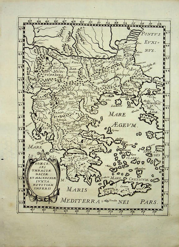
018786[Philippe Briet, Parallela geographiae veteris et novae] Diocèses Thraciae daciae et macedoniae juxta notitiam imperii - Grèce, Macédoine Gravure originale, 1649, environ 240*170mm. Gravure tirée de l'ouvrage du savant jésuite Philippe Briet (1601-1668) publié en 1648-1649. Texte au dos. [436]
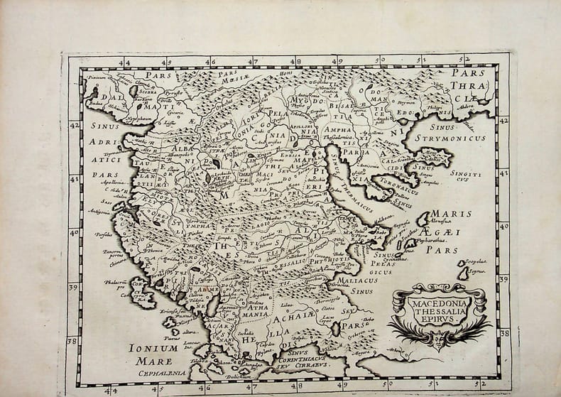
018790[Philippe Briet, Parallela geographiae veteris et novae] Macedonia, Thessalia, Epirus - Macédoine, Thessalie, Epire. Grèce. Gravure originale, 1649, environ 240*170mm. Gravure tirée de l'ouvrage du savant jésuite Philippe Briet (1601-1668) publié en 1648-1649. Texte au dos. [436]
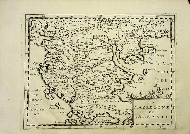
018797[Philippe Briet, Parallela geographiae veteris et novae] La Macédoine et l'Albanie. Gravure originale, 1649, environ 240*170mm. Gravure tirée de l'ouvrage du savant jésuite Philippe Briet (1601-1668) publié en 1648-1649. Texte au dos. [436]
Very Good Turkish, Ottoman (1500-1928) Original color map from an early 20th century Turkish atlas. Oblong folio. (25 x 35 cm). In Ottoman script. No scale. Shows South Iran with Lake Urmia at north and Iraq border at west. Toponyms are mostly in old Turkish. [OTTOMAN MAP of SOUTH IRAN and IRAQ] Simâlî Irak ve Iran haritasi.
Very Good Turkish, Ottoman (1500-1928) Original color map. Folded. Oblong atlas folio. (50 x 60 cm). In Ottoman script. Shows Rhodes and Tilos Islands. Scale: 1/200.000. Hegira: 1332 = Gregorian: 1916. Not description on map-maker. This is one of the series of the Bonn projection maps which are the first map series in modern techniques in Turkey and the Ottoman Empire. This is one of the series of the Bonn projection maps which are the first map series in modern techniques in Turkey and the Ottoman Empire. In order to produce these maps covering Turkish territory, Reconnaissance Branch was incorporated into The Mapping Commission. The maps were produced in the datum based on the latitude and longitude of Ayasofya Mosque in an equal area Bonn Projection. The field works for the 123 sheets covering the country were conducted by 76 staff. The production was completed in 18 years starting from east-west. Fieldworks continued without stopping except in the years 1914 and 1920. This map series called also reconnaissance maps contributed a lot to producing 1:25.000 scale maps. A very detailed and attractive map of Rhodes Island showing its harbors and Ottoman place names.
Very Good Turkish, Ottoman (1500-1928) Original color map. Oblong atlas folio. (51 x 61 cm). In Ottoman script. Folded. Topography and toponyms of East Anatolia: Shows Erzurum region, Hasankale (Pasinler), Oltu, Hinis, Karakilise and surroundings. Scale: 1: 200.000. This is one the serie of the Bonn projection maps which are the first map series in modern techniques in Turkey and the Ottoman Empire. In order to produce these maps covering Turkish territory, Reconnaissance Branch was incorporated into The Mapping Commission. The maps were produced in the datum based on the latitude and longitude of Ayasofya Mosque in equal area Bonn Projection. The field works for the 123 sheets covering the country were conducted by 76 staff. The production was completed in 18 years starting from east west. Field works continued without stopping except in years 1914 and 1920. This map series called also reconnaissance maps contributed a lot to producing 1:25.000 scale maps. Rare.