Sanson MarietteBiblio.com
442 résultats
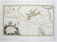
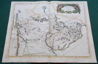
1668014632Paris: Cartes Generales de Toutes les Parties du Monde. 1668. Hand coloured. Map measures 55x40.cm plus margin. Some light surface wear or dust marking. Map in good condition. Boldly engraved map of the region of present day Paraguay Uruguay northern Argentina and parts of Chile and Brazil. The Rio de la Plata is the main feature of the map which extends north to the mythical Lago de los Xarayes. The mountains and volcanoes of the Cordillera de los Andes are also prominently shown. There is good detail of topography missions and villages. The decorative title cartouche is adorned with two female figures fruit and flowers. Very Good. Cartes Generales de Toutes les Parties du Monde.. unknown
0282047352.Gpaperback. Good. Access codes and supplements are not guaranteed with used items. May be an ex-library book. paperback
1954mon0000050986London 1954-01-01. Hardcover. Very Good. 2.5980 cent in x 18.3860 cent in x 13.1900 cent in. Complete with dust wrapper. Rare. London hardcover
1680024707London: William Berry 1680. .Kingdoms and States which are found there at present/Described by Sanson/Corrected and amended By William Berry =Kopftitel; Text der figürlich reich verzierten Kartusche oben rechts: Asia Divided into its Principall Regions in which may be seen the extent of the Empires Monarchies Kingdoms and States which at present divide Asia/To the Most serene and Most Sacred Majesty of Charles II./By the Grace of God King of Great Britain France and Ireland/This Map of Asia is humbly Dedicated and Presented By Your Majesties Loyal Subject and Servand William Berry; Text der reich verzierten Kartusche links oben: Scale es folgen Maßstäbe verschiedener Länder/London/Sold by William Berry at the Sign of the Globe between Charing-Cross and White-Hall/1680; SW-Kupferstich-Landkarte nach Nicolas Sanson d'Abbeville gestochen von William Berry; ca. 51 x 39 cm; Falzspuren einige Tintenflecken hauptsächlich ausserhalb des Druckbildes mässige Lichtverfärbung; professionell hinter Glas gerahmt in schwarzem Holzrahmen; äußerst selten; for description in other languages of this extremely rare map please don't hesitate to contact me. . Gut. Landkarte. William Berry unknown
1916-25Paris H. Jaillot 1692. Alt grenzkolorierte Kupferstichkarte von 2 Platten. 64 5 x 99 cm Blattgr. Breitrandiges Exemplar. Äußere Ränder etwas gebräunt kleiner Randeiniß sonst gut erhalten. Großformatige Karte von Guillaume Sanson 1633-1703 die das Gebiet von Deggendorf bis Wagram und von Kromeríz/Kremsier bis Veszprém/Weissbrünn mit dem Neusiedler See Newsidler See zeigt. Aus dem Verlag von Alexis-Hubert Jaillot um 1632-1712 der eng mit Sanson zusammenarbeitete. Paris, H. Jaillot 1692. unknown
187030523Paris : V. Masson 1870. 195x120mm. VII- reli demi cuir titre dor au dos. 400 V. Masson unknown
1332655343.Gpaperback. Good. Access codes and supplements are not guaranteed with used items. May be an ex-library book. paperback
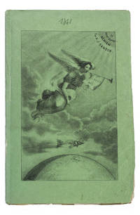
184193KAS1RPK7OLParis 1841. 8vo. De Boulé et Comp. for Ledoyen Original green wrappers in a protective plastic wrapper with a large lithographed plate on the front showing a dirigible flying over the globe underneath a floating angel who is blowing a trumpet with the motto "Conquête de l'aire". With a large folding lithographed plate 40 x 235 cm of the dirigible and a smaller woodcut of the same dirigible on p. 5. 31 1 blank pp. First edition of this very rare early and remarkable brochure on navigation in the air and the dirigible manoeuvrable balloon. The brochure introduces a new project to build a dirigible in the shape of a fish. The cost was estimated at 30.000 francs and was to be financed by the issue of 300 shares of 100 francs. The work explains the expected profits and the workings of the dirigible in order to entice patrons. It is an early example of such a project as the first powered and steerable airship that was able to take flight was invented in 1852 eleven years after the publication of the present work. This curious brochure therefore offers a fascinating insight into the history of aviation.The fish dirigible is shown in detail on the large folding plate. It was proposed to ascend the balloon being in equilibrium by means of wings to obtain propulsion by four small paddle-wheels and to steer by means of a large triangular rudder. It was approximately 25 meters long and 12 meters high and operated from a basket hanging underneath like in a hot air balloon. It was invented by bookseller and author Alexandre-Jacques Sanson 1789-1862 and his father. The dirigible was never built but the Sansons nevertheless published a number of other works elaborating on the same subject in the following years: Navigation atmosphérique. Explications complémentaires sur le système 1845; Explication du système de navigation aérienne 1848 and Solution du problème de la navigation aérienne principes preuves et moyens 1850. The present work ends with a letter by the aeronaut Jules-François Dupuis-Delcourt 1802-1864 giving permission to use some of his data in the brochure and offering his blessing to the project.The wrappers are somewhat creased with tears at the head and foot of the spine. The folding plate has browned. Otherwise in good condition.l Tissandier p. 34; WorldCat 457418223 907812680 1141280150 13 copies. unknown
2329234465.Gpaperback. Good. Access codes and supplements are not guaranteed with used items. May be an ex-library book. paperback
GTC3777Texas Parks and Wildlife Press. Signed by both Sanson and Meinzer 1st ed.; fine condition DJ fine condition. Texas Parks and Wildlife Press unknown
189370475Paris: Librairie Agricole De La Maison Rustique 1893. Quarter-leather. G/No Jacket as issued. 5 volumes published 1893-1901. Library markings; marbled boards; covers edge-rubbed with wear at corners; small scuff on front cover of volume 1; 401 386 366 376 350p illus indexes. NB: This is a heavy set which may incur a non-standard postage charge. Size: 12mo - over 6¾" - 7¾" tall <br/> <br/> Librairie Agricole De La Maison Rustique hardcover
2013728395.Gpaperback. Good. Access codes and supplements are not guaranteed with used items. May be an ex-library book. paperback
2013728387.Gpaperback. Good. Access codes and supplements are not guaranteed with used items. May be an ex-library book. paperback
2013728409.Gpaperback. Good. Access codes and supplements are not guaranteed with used items. May be an ex-library book. paperback
2329225229.Gpaperback. Good. Access codes and supplements are not guaranteed with used items. May be an ex-library book. paperback
8466658815.Ghardcover. Good. Access codes and supplements are not guaranteed with used items. May be an ex-library book. hardcover
1015798438.Ghardcover. Good. Access codes and supplements are not guaranteed with used items. May be an ex-library book. hardcover
2012936229.Gpaperback. Good. Access codes and supplements are not guaranteed with used items. May be an ex-library book. paperback
2382740884.Gpaperback. Good. Access codes and supplements are not guaranteed with used items. May be an ex-library book. paperback
2000mon0004154885Oxford University Press 2/24/2026 12:00:01 A. hardcover. Like New. 0.9500 9.5000 6.5000. Oxford University Press hardcover
194338552D. Appleton -Century. Good with no dust jacket. 1943. Revised Edition. Hardcover. Spine is straight binding is tight name sticker inside the book reading pages have some underlining some wear. Map is in very good condition and comes with the book.; 9x6x1.5; 554 pages . D. Appleton -Century hardcover
2003Q-0972123342MCD Century Publications 2003-06-01. Paperback. New. In shrink wrap. Looks like an interesting title! MCD Century Publications paperback
2003DADAX0972123342Brand: MCD Century Publications 2003-06-01. paperback. New. 1.00x10.00x9.00. Buy with confidence. Excellent Customer Service & Return policy. Brand: MCD Century Publications paperback
1678M3431Paris: Mariette Pierre 1678. Excellent. Size : 357x595 mm 14x23.375 Inches Coloring: Original Outline with later cartouche coloring Category: ; Maps Asia Near East Turkey Mariette, Pierre unknown
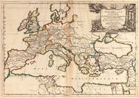
166725060Paris: P. Mariette 1667. Other. The centre fold minor spotting else in excellent condition. 395 by 565mm 15 by 22 inches. Rare and decorative large-format historical map of Europe showing the locations of Church Councils and Synods in original outline color. By Guillaume Sanson 16331703 Géographe du Roy published by Pierre Mariette Paris 1667. Image: 395 x 565 mm 15.5 x 22 inches. Decorated with a superb allegorical title cartouche depicting a Catholic council in session a unique historical and cartographic document. Guillaume Sanson 16331703 was a leading French cartographer who inherited the celebrated family firm from his father Nicolas Sanson 16001667 known as the 'Father of French Cartography' and official Géographe du Roy to Louis XIV. Like his father Guillaume held the title of Géographe Ordinaire du Roy. Much of his work after 1671 was published in collaboration with Alexis-Hubert Jaillot and together the Sanson dynasty dominated French cartography throughout the 17th century. Their maps are held in the Bibliothèque nationale de France the British Library and major research collections worldwide.This large and striking map plots the locations of ecumenical councils national synods provincial councils and diocesan synods across Europe a unique cartographic subject of combined religious and historical significance. The coverage extends from the British Isles and Iberian Peninsula across to the eastern Mediterranean including Cyprus and Syria with North Africa also shown. Political borders are rendered in hand-applied outline color. The splendid allegorical title cartouche depicts a Catholic council in session and was engraved to the highest standard of the Parisian workshop. The Geographia Synodica is among the most unusual and collectible maps ever published of Europe: a historic document of scholarship faith and cartographic craft. In excellent condition. Original outline color fresh and vivid. The centrefold shows minor spotting as expected for a 17th-century map of this size; all else excellent. No tears or significant foxing. 395 x 565 mm. P. Mariette unknown