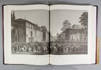
2 100 résultats
Very Good English Original color engraving with its frame. Oblong folio. (28 x 41 cm). Description in English. Originally folded. It's in frame. It's from the book named 'A Journey through Albania, and other Provinces of Turkey in Europe and Asia, to Constantinople, during the years 1809 and 1810' by John Cam Hobhouse printed in 1813, London. Attractive one of 17 color plates in the book. Scarce.
1897237507Constantinople 1897. 10 x 7-3/4 inches. Mounted. Slightly faded. 10 x 7-3/4 inches. Photo/Wh/2/up unknown
CJW1322Bern: Ertug & Kocabiyuk 2002. No. 46 OF 50 SPECIALLY BOUND COPIES of a total edition of 350. 670 x 508 mm. 26 3/8 x 20". 3 p.l. 10 pp. 63 leaves. <br/> Publisher's scarlet morocco by Buchbinderei Burkhardt AG covers with gilt-rolled border cornerpieces tooled in gilt upper cover with gilt calligraphic Arabic centerpiece lower cover with gilt central heraldic device marbled endleaves all edges gilt. With a portrait frontispiece of Emperor Selim III 48 DOUBLE-PAGE PLATES AND THREE DOUBLE-PAGE MAPS. ◆A virtually as-new copy.<br/> <br/> This is one of the deluxe copies of a modern facsimile of Melling's massive and magnificently illustrated work devoted to 18th century Constantinople a book that provided the earliest interior views and plans of the harems and palaces of Sultan Selim III when it was published in 1819. The illustrations remain the best and certainly most attractive record we have of the city during this era in its history. Our edition was produced from a copy of the elephant folio first printing in the collection of the facsimile's publisher Ahmet Ertug with images faithfully reproduced in their original mammoth size 650 x 970 mm. After his arrival in Constantinople in 1795 architect and painter Antoine Ignace Melling 1763-1831 was appointed imperial architect by Selim III. In the course of his duties he designed and landscaped a seaside palace for Selim's sister Princess Hatice and produced these striking panoramic views of the city and its environs. After completing the palace and a number of other building projects for Selim he returned to Paris and in 1804 issued a prospectus for this work. He established an engraving studio in 1809 to reproduce these drawings and began publishing the completed prints as a series of fascicles that were sent to subscribers. The last one appeared in 1819. The outstanding success of an exhibition of the paintings on which the "Voyage Pittoresque" was based earned Melling the rank of painter to the Empress Josephine. When "Voyage Pittoresque" was originally published booksellers in England sold copies for £84 a huge sum for a book at the time. The original edition in pleasing condition now fetches between $75000 and $100000. Our handsomely bound actual size facsimile offers an attractively priced alternative. Ertug & Kocabiyuk unknown
190829650Partitions sur la Turquie Bosc 1908
New English Original bdg. 4to. (28 x 24 cm). In English and Turkish. 151 p., ills. Jameel Prize 4.= 4. Jameel Ödülü. [Exhibition catalogue]. Edited by Begüm Akkoyunlu Ersöz, Salma Tuqan, Tania Bahar, Tim Stanley. Jameel Prize 4 exhibition in Istanbul organised by the Victoria and Albert Museum, London in partnership with Art Jameel, and in collaboration with the Pera Museum is between 8 June 2016 and 14 August 2016. Over 280 nominations for the Jameel Prize 4 were received from countries as far ranging as Afghanistan, Mali, Puerto Rico and Thailand. A panel of judges, chaired by V&A Director, Martin Roth, selected the shortlist. Works on show will range from delicate paper collages to an animated video installation with marionettes and from ceramics, calligraphy and sculpture to artist's books. The winner will be announced in June. The eleven shortlisted artists and designers are David Chalmers Alesworth, Rasheed Araeen, Lara Assouad, CANAN, Cevdet Erek, Sahand Hesamiyan, Lucia Koch, Ghulam Mohammad, Shahpour Pouyan, Wael Shawky ve Bahia Shehab. The Jameel Prize 4 exhibition in Istanbul is organised by the Victoria and Albert Museum, London, in partnership with Art Jameel, and in collaboration with the Pera Museum.
Very Good Greek, Modern (post 1453) Original wrappers. Large 8vo. (21 x 16 cm). In Greek (Modern). 21 p. First and only edition of this exceedingly rare and one of the earliest church regulations of the Greek Orthodox community of Attalia [Antalya]. Attalia was not a large urban center or major trading hub, but neither was the Greek Community marginal, and it was well integrated into the regional economy. It was different from other areas in Asia Minor due to a combination of factors ranging between demography, geography, local Orthodox leadership, and the city's social milieu. In contrast to the West-coast cities and many villages in Asia Minor with Orthodox majorities, Attalia's population was only about one-third Orthodox. The main area of difference in Antalya was the Community leadership, which was key to the maintenance of cordial relationships between Christians and Muslims, and the secular and ecclesiastical elements of Orthodox leadership in Antalya tended to cooperate for collective benefit. Throughout this period, a local elite managed to control education and other Community institutions, perpetuating an identity that was compatible with the local Ottoman context. In this last period, the Greek Community printed several books and tractates including a brief history of Antalya and this "regulation book" in the Meli Printing House, which was the only printing house of the Greek Community in Antalya. Only one institutional copy is located in OCLC 1030075331 (Suna Kiraç Library of the Koç University).
Very Good Turkish, Ottoman (1500-1928) Original color lithograph map. Folded. Oblong folio. (35 x 52 cm). In Ottoman script (Old Turkish with Arabic letters). It shows Sudan and West Africa, Atlas Ocean shores, Sahra Desert, and other parts of Africa. Scale: 1:15.000.000. A very detailed and attractive map. Slightly fading. Otherwise a very good copy. Dated Hegira: 1310 = [Gregorian 1894]. Taken from his attractive atlas titled "Yeni cografya atlasi. [i.e. New Geographical Atlas]". The cartographer, Ali Seref, or Hafiz Ali Seref (or Esref) Pasha (1840-1907) was an Ottoman soldier and mapmaker who was schooled in Paris as a cartographer around 1862. While in Paris he published his first atlas with 22 maps, called the Yeni atlas. Upon his return to Istanbul, he became the chief cartographer at the Matbaa-i Amire Printing Press in Beyazit. Chipping on extremities. Slight foxing. Overall a good copy. Not in OCLC.; Not in TBMM Map Collection.
Very Good Turkish, Ottoman (1500-1928) Original color map. Folded. Oblong folio. (35 x 52 cm). In Ottoman script. Color lithograph. It shows Sudan and West Africa, Atlas Ocean shores, Sahra Desert, and other parts of Africa. Scale: 1:15.000.000. A very detailed and attractive map. Slightly fading. Otherwise a very good copy. Dated Hegira: 1310 = [Gregorian 1894]. [EARLY OTTOMAN MAP of SUDAN] Sudan. Sâye-i Türkiye Hazret Gazi Sultan Abdülhamid Hân-i Sâni'de Maarif Umûmiye Nezâret-i Celîlesi ruhsatiyle meshur Haset tarafindan Fransa Cemiyet-i Cografya âzâlarindan mütesekkil komisyona mahsûs tanzîm edilmis oldugu son defaki atlasinin tercümesi olarak bu def'a Erkân-i Umûmiyye Dairesi Besinci Fen Subesi'ne me'mûr piyade mirlivâlarindan saâdetlü Ali Seref Pasa ve rifatlubinbasi fütûvvetlü Muhyiddin Efendi maarifetleriyle tertib ettirilmistir. Ali Seref Pasa or Hafix Ali Esref. He was a soldier, who was schooled in Paris as a cartographer around 1862. Already in Paris he published his first atlas with 22 maps, called 'Yeni atlas'. Upon his return to Istanbul he became a chief cartographer at the Maatbaa-i amire Printing Press in Beyazit, which was the successor of the Muteferrika press from 1727. Among others he translated the large Kiepert map of Anatolia to Ottoman. He died in 1907, leaving his large project of a gigantic map of Anatolia in 100 sheets unfinished. Ali's name is often misunderstood or even listed as two different people: Ali Seref Pasa and Hafiz Ali Esref. Until the surname law adopted on June 21, 1934, Turks did not have surnames. They were born with one first name and were until the adulthood described only as sons or daughters of their parent's names. Later they were given titles such as Effendi (Sir), Bey (Chief) or Hanim (Madam) for higher classes, or they were given names according to their work or class. The names were not inherited by children until 1934, when the surname law was enforced. The map maker Ali received names Seref, the honourable, and Pasa, the dignitary. He was also known as Hafiz, the memorizer of Qur'an and Esref, Proud. So Ali Seref Pasa would have a meaning 'Honourable Dignitary Ali, and Hafiz Ali Esref, Memorizer of Qur'an, Proud Ali. Daruttibaa - Matbaa-I Amire Printing Press: The first press in the Muslim world, called Daruttibaa, was founded in Istanbul by Ibrahim Muteferrika in 1727, with a permission of Sultan Ahmeet III. It was located in Muteferrika's house. The first book was published in 1729 and until 1742 sixteen other works followed. After Muteferrika's death, the press was supressed for printing, as printed books were considered dangerous. In 1796 the press was purchased by the government and moved to Uskudar in Istanbul, and in 1831 finally to Beyazit, where it was renamed to Matbaa-i Amire in 1866. The press was closed in 1901 and was reopened in 1908 under the name 'Âmire' In 1927 the name changed to State Printing House. The press still exists and is known for publishing school and educational books. Extremely rare. Not in OCLC.; Not in TBMM Map Collection.
Very Good Turkish Original manuscript map of Alexandria Port and its immediate hinterland. Folio. (33 x 41 cm). In Turkish (Modern). Folded. No scale. The manuscript shows Alexandria Port and the Palace of the King Farouk of Egypt, customs shores, ports and harbors, locations of the British ships, radio station, location of SS Ramlah, strait, Great Pass (?), waterfront for the lumber ships, sea current zones and probably entrance and exit routes etc. A very detailed map, decorated with ships. Some repairs with tape, tears, foxing and stains. Overall a good copy.
1995LFA-126746922N° 315 (Septembre 1995) : revue de 78 pages, format 215 x 285 mm, illustrée, brochée couverture couleurs, bon état
2010LFA-126747129N° 473 (Janvier 2010) : revue de 82 pages, format 215 x 285 mm, illustré, broché couverture couleurs, bon état
LFA-126743988Pochette contenant 6 cartes, format 255 x 330 mm, s.d. (années 1914-1918) Librairie Larousse, bon état
17821183461782,1809,1822 in-folio A Paris, chez J. J. Blaise, 1782-1809-1822, 5 volumes grand in-folio comprenant 3 titres gravés, 1 portrait d'après Boilly, deux cartes dépliantes de la Grèce non numérotées, le tableau dépliant de" La Race de Dardanus" et 284/285 vues (numérotées de 1 à 126, SANS la 110; de 1 à 157 dont deux "bis").Tome I : (4) ff. (faux-titre, page de titre, frontispice, explication du frontispice), XII (discours préliminaire), 204 pages, 125/126 planches - Tome II, en 4 volumes en pagination continue, 159 planches (157+2 bis). Première partie : (4) ff. (faux-titre, page de titre, explication du frontispice), 1-176 pages; 177-346 pages; Seconde partie : 347-448 pages; XII, 449-518 pages (MANQUENT 2 feuillets, p.469 à 472). INCOMPLET mais tout de même rare ensemble. Reliure d'attente, papier à la colle, en mauvais état (dos d'un volume manquant, autres dos réparés avec scotch blanc etc). Quelques rousseurs, le volume II.2 particulièrement dégradé par le travail d'humidité et les traces de mouillures, sinon intérieur en bon état général. PRÉVOIR POUR EXPÉDITION : plus de 18 kg sans emballage.
173510011London: Printed for George Spavan 1735. First Edition. Hardcover. Very good. Octavo. 4.625 x 7.125 inches. 2 blanks 86 2 blanks pp. A British account of 18th-century Constantinople by an anonymous author "a gentleman" from the retinue of George Hay the 8th Earl of Kinnoul British ambassador to Constantinople 1729-1737. Title page professionally reinforced at an early date. Very good. Rebound in red textured cloth titled in gilt on spine with gilt monogram to upper cover all edges gilt. Classical archaeologist Henry Schroder Robinson's copy with his ex libris label affixed to front pastedown; inscribed to Robinson on front free endpaper "To Henry / the Bibliophile / as a token of appreciation / from / The Gennadius Library / June 30 1969". Text bright and unmarked binding square and tight. Very scarce with three copies appearing in libraries worldwide OCLC and no auction records. The Gennadius Library is located within the American School of Classical Studies at Athens. Printed for George Spavan hardcover
86461The Hague Jean Neaulme 1737. . First edition first issue. Small 8vo iv 164 viiiadspp. title printed in red and black with engraved device small stain to title light waterstain to inner upper margin bound in recent green morocco backed marbled boards spine gilt lettered.<br /> mba004 This account describes the two rebellions which broke out during the unsettled period following the victories of Nadir Kuli Khan of Persia against Turkey during September 1730 and which brought to and end the 'Tulip Period'. On the 20th of that month a minor riot developed into a full scale insurrection and Sultan Ahmet III was forced to abdicate in favour of his nephew Mahmoud I. The janissaries were led by one of their own an Albanian by the name of Patrona Halil and for two months the empire was in the hands of the insurgents. They were eventually overthrown by the Grand Vizier the Mufti and Aga of the Janissaries with the help of the Khan of the Crimea and Patrona and 7000 of his supporters were put to death. The first issue has the title printed in red and black as here.<br /> Atabey 1026; Blackmer 1407. The Hague, Jean Neaulme, 1737. hardcover
19372Londres et Parois, Fisher, Son & Cie, s.d. 3 séries en 1 vol. in-4, XLII-60 pp. 30 (sur 32) pl. + 58 pp. 31 (sur 32) pl. + 54 pp. 32 pl., demi-basane havane (dos manquant, reliure défraîchie, rousseurs et taches, 3 planches manquantes).
LFA-126714582Un document de 30 planches photographies, format 235 x 175 mm, broché, s.d. (première moitié du XXe siècle), bon état
9033Leipzig, 1905. In 12 percaline rouge de l’éditeur, XXIV-275 pp.
Near Fine Turkish Paperback. Cr. 8vo. (20 x 14 cm). In Turkish. 238, [1] p., portraits, facsimiles, and other b/w plates. First and Only Edition of this rare early book on the secret activities of M. M. Group [i.e. "Mim Mim Group'] in Istanbul during the Armistice and the Turkish War of Independence (1919-1922). Signed copy. Mim Mim Group was an intelligence group service which was officially recognized by the Turkish Grand National Assembly (TBMM). Enver and Talat Pashas were involved in its enterprise. OCLC 1085195655.
Very Good Turkish, Ottoman (1500-1928) Original color map on cloth. A little foxing on cloth. Very good. Folded. Oblong atlas folio. (50 x 67 cm). In Ottoman script. Scale: 1/300.000. Map of Ottoman Kayseri printed in its period. No publisher and map-maker. Physical geography of Kayseri city and its around. It shows Kayseri, Sultan Sazligi, mountains and hills, Malatya borders, etc.
Very Good Turkish, Ottoman (1500-1928) Original color map on cloth. Oblong eephant folio. (64 x 573 cm). Toponyms in Ottoman script. [MAP of BALKANS] Filibe [Plovdiv]. A very detailed map. Shows Plovdiv and mountains, rivers around it. Extremely rare.
Very Good French Original color map on cloth. Oblong folio. (42 x 53 cm). In Ottoman script. [MAP] Büyükada, Maltepe ve Adalar. [Feuille of Sedef Island and South of Prinkipo, Marmara Sea]. 6th sheet of set.
Very Good French Original color map on cloth. Oblong large folio. (49 x 58 cm). In Ottoman script. [MAP] Kocaeli-Izmit Körfezi. Gökbüze, Derince, Dilburnu, Hersek Gölü. [Izmit Bay, Dilburnu, Gökbüke, Derince, Marmara Sea]. Scale: 1/50.000.
Very Good Turkish, Ottoman (1500-1928) Original Ottoman manuscript historical document. 28x21,5 cm. In Ottoman script (Old Turkish with Arabic letters). 10 lines on 1 p. Signed, and three Ottoman stamps. During the Haydarpasa Fire in 1922, the warning about the Jewish resident of Beyoglu Vitali Efendi's house on Haydarpasa, Mandira Street, where the windows were broken and they were not fitted. The aforementioned warning was prepared by Vitali Efendi's tenant "Abulafya". Transcription in Turkish: "Dersaadet Kâtîb-i Adlîligi Memûriyet-i Valâsina: Efendim, Beyoglu'nda, Tozkoparan'da Bahar Apartmani'nda mukîm Mösyö Vitali Bahar'in Haydarpasa'da, Mandira Sokagi'nda 80 numero ile mudkîm bir bab hanesinde müstecîren ikâmet etmekteyim. Geçen hafta vuku' cevelân harikte, harikin tesîrâti ile hanenin pencerelerinde mevcut camlar kirilip harap olmustur. Kendisine...". The fire in Haydarpasa 1922 came to be known in history as "the Fire of Haydarpasa Çayir", because it broke out in one of the houses in Çayirbasi and spread further. It broke out on July 29, 1922.
Very Good Turkish, Ottoman (1500-1928) Original color map. Folded. Oblong atlas folio. (50 x 60 cm). In Ottoman script. [MAP of EAST ANATOLIA] Malatya - Divrigi, Mancinik, Adiyaman, Harput. Shows Malatya, Adiyaman and Kharpout region; Firat River (Euphrates), Yazi Düzü, Erguvan etc. Scale: 1/200.000. This is one the serie of the Bonn projection maps which are the first map series in modern techniques in Turkey and the Ottoman Empire. In order to produce these maps covering Turkish territory, Reconnaissance Branch was incorporated into The Mapping Commission. The maps were produced in the datum based on the latitude and longitude of Ayasofya Mosque in equal area Bonn Projection. The field works for the 123 sheets covering the country were conducted by 76 staff. The production was completed in 18 years starting from east west. Field works continued without stopping except in years 1914 and 1920. This map series called also reconnaissance maps contributed a lot to producing 1:25.000 scale maps. Hegira: 1332 = Gregorian: 1916. Not description on map-maker. According to Türkezer & Çobanoglu: History of Mapping in Turkey-1:200.000 Scale Maps, cartographer of this map is Kambay, Cemal.