MUNTING, AbrahamBiblio.com
285 résultats
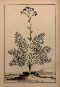
1696324019Leyden and Utrecht: Pieter Vander Aa 1696. unbound. Botanical. Copper plate engraving with hand coloring. Image measures 12.25" x 8"<br/> <br/> Lovely image of a flowering Ageratum plant with a simple distant landscape depicted in the background. Abraham Munting 1626-1683 taught medicine and botany at the Academy of Groningem in the Netherlands. He had a particular interest in the uses of plants especially medicinally. This engraving is from "Naauwkeurige Beschryving Der Aardgewassen". Aging around edges and minor foxing. Please visit our gallery for more Munting prints.<br/> <br/> Pieter Vander Aa unknown
1696211441Leyden and Utrecht: Pieter Vander Aa 1696. unbound. very good. Botanical. Copper plate engraving with hand coloring. Image measures 12.5" x 8.25".<br/> <br/> Abraham Munting 1626-1683 taught medicine and botany at the Academy of Groningem in the Netherlands. He had a particular interest in the uses of plants especially medicinally. This engraving is from "Naauwkeurige Beschryving Der Aardgewassen". Aging around edges. Please visit our gallery for more Munting prints.<br/> <br/> Pieter Vander Aa unknown
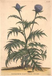
1696324021Leyden and Utrecht: Pieter Vander Aa 1696. unbound. Botanical. Copper plate engraving with hand coloring. Image measures 12 1/2" x 8 1/2".<br/> <br/> Fine print of a purple thistle-like flowering plant with jagged leaves. <BR> <BR> Abraham Munting 1626-1683 taught medicine and botany at the Academy of Groningem in the Netherlands. He had a particular interest in the uses of plants especially medicinally. This engraving is from "Naauwkeurige Beschryving Der Aardgewassen". Aging around edges and minor foxing. Please visit our gallery for more Munting prints.<br/> <br/> Pieter Vander Aa unknown
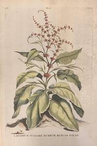
1696324022Leyden and Utrecht: Pieter Vander Aa 1696. unbound. Botanical. Copper plate engraving with hand coloring. Image measures 12 1/2" x 8 1/2".<br/> <br/> Beautiful print of a flowering Rumex acutus plant. Abraham Munting 1626-1683 taught medicine and botany at the Academy of Groningem in the Netherlands. He had a particular interest in the uses of plants especially medicinally. This engraving is from "Naauwkeurige Beschryving Der Aardgewassen". Aging around edges and minor foxing. Please visit our gallery for more Munting prints.<br/> <br/> Pieter Vander Aa unknown
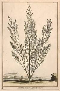
1696324020Leyden and Utrecht: Pieter Vander Aa 1696. unbound. Botanical. Copper plate engraving with hand coloring. Image measures 12" x 7 3/4".<br/> <br/> Handsome image of a plant belonging to the sedum genus commonly known as stonecrops. Abraham Munting 1626-1683 taught medicine and botany at the Academy of Groningem in the Netherlands. He had a particular interest in the uses of plants especially medicinally. This engraving is from "Naauwkeurige Beschryving Der Aardgewassen". Aging around edges and minor foxing. Please visit our gallery for more Munting prints.<br/> <br/> Pieter Vander Aa unknown
1696211444Leyden and Utrecht: Pieter Vander Aa 1696. unbound. very good. Botanical. Copper plate engraving with hand coloring. Image measures 12.75" x 8.5".<br/> <br/> Beautiful botanical print. Abraham Munting 1626-1683 taught medicine and botany at the Academy of Groningem in the Netherlands. He had a particular interest in the uses of plants especially medicinally. This engraving is from "Naauwkeurige Beschryving Der Aardgewassen". Aging and scattered foxing around edges and margins. Please visit our gallery for more Munting prints.<br/> <br/> Pieter Vander Aa unknown
1612406876Antwerp 1612. Tape reinforcements along edge on verso without show-through and not affecting image a few foxmarks overall in very good condition with good color. Hand colored engraved map 12 5/8 x 9 7/8 inches image 16 1/2 x 10 5/8 inches sheet. Crossed arrows watermark. A fine map from Ortelius's atlas showing Lake Constance the Danube and Rhine. Bounded by the Lech Odenwald Alsace and Chur in Switzerland. <br/><br/> unknown books
1678T01385London: Henry Herringman 1678. 5th Edition . Leather. Good. 8 x 12. Pages are in remarkably good condition; occasional stains and bookworm tunnels. Endpapers stained on the edges. Frontispiece illustrated with a portrait of the author. Full brown leather. Six raised bands gilt titles and decoration on the spine. Spine is chipped faded and rubbed; pulling away from the boards at the head/tail. Corners bumped and frayed bottom corner on the upper cover is cracked but intact. Covers are scuffed. Binding secure. GOOD <br/> <br/> Henry Herringman hardcover
16018877Antwerp Johann Baptist Vrients 1601. Copper engraving 7.5 x 11 cms black and white Latin text on verso. Sicily from the second series of maps engraved by Philip Galle for the Epitome the pocket atlas version of Ortelius Theatrum. Koeman Atlantes Neerlandici Ort 58 Map unknown
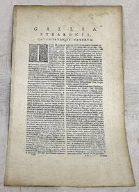
161223589Antwerp: Juan Baptist Vrients 1612. Other. In excellent condition. 365 by 504mm 14 by 19 inches. Original antique copper engraving published 1612 in the famous Italian text edition of the" Theatrum Orbis Terrarum published by Juan Baptist Vrients in Antwerp. An early and decorative map of Burgundy in France by Abraham Ortelius which is based on the cartographical sources Ferdinand de Lannoy who made a map of Burgundy in 1563 for which he obtained a privilege but which was subsequently suppressed by the Spaniards for political reasons Broe. Ortelius was born on 14 April 1527 in the city of Antwerp which was then in the Habsburg Netherlands modern-day Belgium. The Orthellius family were originally from Augsburg a Free imperial city of the Holy Roman Empire. In 1535 the family had fallen under suspicion of Protestantism. Following the death of Ortelius's father his uncle Jacobus van Meteren returned from religious exile in England to take care of Ortelius. Abraham remained close to his cousin Emanuel van Meteren who would later moved to London. In 1575 he was appointed geographer to the king of Spain Philip II on the recommendation of Arias Montanus who vouched for his orthodoxy. He travelled extensively in Europe and is specifically known to have traveled throughout the Seventeen Provinces; in southern western northern and eastern Germany e.g. 1560 15751576; France 15591560; England and Ireland 1576; and Italy 1578 and perhaps twice or thrice between 1550 and 1558. Beginning as a map-engraver in 1547 he entered the Antwerp Guild of Saint Luke as an illuminator of maps. He supplemented his income trading in books prints and maps and his journeys included yearly visits to the Frankfurt book and print fair where he met Gerardus Mercator in 1554. In 1560 however when travelling with Mercator to Trier Lorraine and Poitiers he seems to have been attracted largely by Mercator's influence towards the career of a scientific geographer. Wikipedia Broe. 51 Juan Baptist Vrients unknown
1681467812London : Henry Herringman 1681. Seventh Edition. Hardcover. Reading copy with a remarkably well-preserved text block and heavily worn exterior. Front board detached from full-leather binding with raised spine bands; both boards scuffed and heavily worn at edges with some surface loss. Frontispiece lacking; title page detached. Text block otherwise tight bright and clean apart from faint sparse dust-dulling to margins. Text edges marbled. A very serviceable example. Physical description; 42 41 1 80 4 70 154 23 1 148 pages 1 leaf of plates ; 30 cm. ESTC ; R21123. Notes; ""The mistress"" ""Pindarique odes"" and ""Davideis"" each have special title pages. Includes: An account of the life and writings of Mr. Abraham Cowley / by T. Sprat. Subjects; Cowley Abraham. English poetry. English prose literature. Satire. 17th century. Illustrated London : Henry Herringman hardcover
1680LV2130Amsterdam: Abraham Wolfganck; La Haye:: Adriaen Moetjens 1680 1679. 1680. Six parts in four volumes. 12mo. xxviii 363 2 364-781 15; xx 771 21; xii 588 12; xvi 379 2 blank 2 379-750 16 pp. Includes letters and documents in French and in Latin German Spanish Dutch and Italian with French translations. Printer’s device on title armillary sphere 2 engraved folding plates showing scene of negotiation at a table surrounded by fine tapestries vol. I facing p.1 III facing p. 438 indexes; gutter stains in vol. 1. Original mottled calf with gilt-stamped spine and four raised bands red speckled edges; worn joints broken on second and third vols. while the first and last vols. are crudely re-backed in cloth and have new endpapers. Ownership blind embossed stamp on first and last few leaves including titles. As is. Second edition vols. 1-3-4; vol. 2 is a first edition of 1679 vastly expanded as the first two volumes were not a part of the 1679 issue. A rare compilation of 17th century diplomatic texts treatises negotiations and correspondence. This work is about the Treaties of Peace of Nijmegen. These series of treaties signed in the Dutch city of Nijmegen between August 1678 and December 1679 ended various interconnected wars among France the Dutch Republic Spain Brandenburg Sweden Denmark the Prince-Bishop of Munster and the Holy Roman Empire. A third edition was issued in 1697 though it is essentially a reprinting of this 1680 issue. Locations: Cambridge Cathedral Libraries Edinburgh National Library of Scotland Oxford.See: Alphonse Willems Les Elzevier: histoire et annales typographiques 1880 p. 523-24 describes this work in 7 parts but six parts as above is correct; Kent McNeil Native Rights and Boundaries of Rupert’s Land and the . . . University of Saskatchewan. Native Law Centre 1982 p. 16. Adriaen Moetjens, 1680, 1679. hardcover books
16482202010003Amsterdam: Nicolaes Visscher; Joan Blaeu 1648. Maps. Very Good. Map of France by Abraham Ortelius. Dimensions: 23 1/4 x 18 3/4. Engraving with early hand coloring removed from an atlas fol. 59 with a vertical crease at center and typography on verso. Nicolaes Visscher; Joan Blaeu unknown
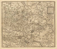
161218807Antwerp: Juan Baptist Vrients 1612. Other. In excellent condition. 375 by 458mm 14 by 18 inches. Original antique copper engraving published 1612 in the famous Italian text edition of the" Theatrum Orbis Terrarum published by Juan Baptist Vrients in Antwerp. An early and decorative map of the duchy of Burgundy in France by Abraham Ortelius published and printed from 1584 for the first time onwards. Ortelius was born on 14 April 1527 in the city of Antwerp which was then in the Habsburg Netherlands modern-day Belgium. The Orthellius family were originally from Augsburg a Free imperial city of the Holy Roman Empire. In 1535 the family had fallen under suspicion of Protestantism. Following the death of Ortelius's father his uncle Jacobus van Meteren returned from religious exile in England to take care of Ortelius. Abraham remained close to his cousin Emanuel van Meteren who would later moved to London. In 1575 he was appointed geographer to the king of Spain Philip II on the recommendation of Arias Montanus who vouched for his orthodoxy. He travelled extensively in Europe and is specifically known to have traveled throughout the Seventeen Provinces; in southern western northern and eastern Germany e.g. 1560 15751576; France 15591560; England and Ireland 1576; and Italy 1578 and perhaps twice or thrice between 1550 and 1558. Beginning as a map-engraver in 1547 he entered the Antwerp Guild of Saint Luke as an illuminator of maps. He supplemented his income trading in books prints and maps and his journeys included yearly visits to the Frankfurt book and print fair where he met Gerardus Mercator in 1554. In 1560 however when travelling with Mercator to Trier Lorraine and Poitiers he seems to have been attracted largely by Mercator's influence towards the career of a scientific geographer. Wikipedia Broe. 54 Juan Baptist Vrients unknown
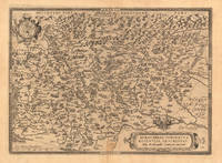
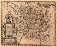
161233375Antwerpen: Juan Baptist Vrients 1612. In excellent condition. 368 by 430mm 14 by 17 inches. Hand-Colored Original Copperplate Engraving by Abraham Ortelius depicting Mansfeldiae Comitatus Descriptio auctore Tilemanno Stella. Sig. Published Antwerpen Juan Baptist Vrients 1612. Sheet: 368 by 430mm 14 by 17 inches. A fine and original hand-colored example of Ortelius's celebrated cartographic work documenting this region of Germany with the precision and decorative artistry characteristic of the 16100s. Abraham Ortelius 1527-1598 was a Flemish cartographer and geographer from Antwerp widely regarded as the creator of the first modern atlas. His landmark publication Theatrum Orbis Terrarum 1570 set the standard for atlas-making for the next century presenting uniform copper-engraved maps with scholarly commentary. By Ortelius's death the Theatrum had appeared in 25 editions in seven languages. In 1575 King Philip II of Spain appointed him Royal Geographer. His maps engraved with extraordinary precision are among the most sought-after in antique cartography held in collections including the Plantin-Moretus Museum in Antwerp the Library of Congress and the British Library.This original copperplate engraving with original hand coloring depicts the region of Mansfeldiae Comitatus Descriptio auctore Tilemanno Stella. Sig. published in Antwerpen Juan Baptist Vrients 1612. The map features a decorative Baroque cartouche containing the title inscription. A distance scale is incorporated within the cartouche or alongside it. The map records the political and geographic boundaries of the region as understood in 1612 offering a fascinating window into the history of German territorial organization. Sheet measures 368 by 430mm 14 by 17 inches. In good condition overall with minor signs of age appropriate for a 17th-century engraving. Ready to frame. Broe. 94 Koeman 32 Juan Baptist Vrients unknown
1696211447Leyden and Utrecht: Pieter Vander Aa 1696. unbound. very good. Botanical. Copper plate engraving with hand coloring. Image measures 12.5" x 8.25".<br/> <br/> Beautiful side profile of a banana tree attached to a base. Abraham Munting 1626-1683 taught medicine and botany at the Academy of Groningem in the Netherlands. He had a particular interest in the uses of plants especially medicinally. This engraving is from "Naauwkeurige Beschryving Der Aardgewassen". Aging around edges and minor foxing. Adhesive residue verso slightly visible to left side. Please visit our gallery for more Munting prints.<br/> <br/> Pieter Vander Aa unknown
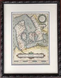
1610H15377Amsterdam 1610. Very Good. 13.5 x 9.75 inches double-matted and nicely framed; frame measures 20 x 16 inches. With original hand coloring very good with mild surface soil. Not examined outside of frame. This is the left-hand map of a sheet that had on the right a detailed map of Jutland. Part of Ortelius's Theatrum Orbis Terrarum considered the first great world atlas. unknown
1636254CLASHU1Ex Officina Elseviriorum Bonaventure & Abraham Elzevier Lugd. Batavor. Leiden: 1636. 1636 pp. 20 96 24. Solitaire printer's mark. Small 24mo. 122 x 70 mm. Early plain vellum binding. A guide to princely behavior first issued by Elzevier the year before. The Dutch family of Elzevier Elzevir; Elsevier were the foremost printers of their time. They produced a vast variety of well printed scholarly and popular books; many in a very small handy format. Louis Elzevier the founder of the firm produced his first book in Leiden in 1583. The 'golden age' of Elzevier printing was between 1620 and 1680. The Elzevier dynasty probably produced their last publication in 1770. Willems 442. PRICE JUST REDUCED! SMALL BOX 2/SH U10 Language: eng. Full Vellum. Hardbound. Very Good. Ex Officina Elseviriorum [Bonaventure & Abraham Elzevier], Lugd. Batavor. (Leiden): 1636. hardcover
16873053Oxford: Printed at Oxford 1687. First edition. 4to.12260pp. Cont. tooled paneled calf a bit worn surfaces pitted extremities of spine chipped front hinge split but still holding. Calf spine label listing the author as "Walker" chipped. Woodcut title page portrait. Minor worming at top blank margins text unaffected. The first four parts alluded to in the title were separate works published during Woodhead's lifetime. "Part V" is based on unpublished manuscripts found after his death in 1678. Wing W3440. Printed at Oxford unknown books
1646910379CGParis:, Mariette, 1646. Grenzkolorierter Kupferstich 40,5 x 54 cm, Blattgröße 43,5 x 59 cm.
1700032854London : Charles Harper 1700 A good copy of the Seventh Edition with Additions of the Second Part of Cowley's works bound with the Second Edition of the Third Part - his Six Books of Plants. In 1800's quarter leather binding with marbled boards and title label with gilt compartments to spine. The spine is worn at the joints particularly at the front some splitting starting at the top and with wear at the top spine end with some fraying. There is wear to edges and corners. The binding is currently sound. Page edges yellowed. Armorial bookplate of Edward Cheney 1803-1884 the art collector and water colour painter of Badger Hall Shropshire to front pastedown. Cheney's note of purchase in Rome in 1833 on fep. Pagination: 14164201662. With frontispiece and vignette to title for the Second Part of the works. Each work has its own title page ad lectorem etc. Pagination restarts with the Third Part. Contents overall very clean and in good to very good condition. There is a mispagination - 16-3-18. There is darkening in the gutter at pp 88/89; some brown toning to some leaves eg 121/2 127/8 and 161/2; and occasional darkening at the top page edge probably from soot. Page marker present. Please enquire if you would like to see additional images. Charles Harper hardcover
16028879Amsterdam c. 1602. Copper engraving 8 x 11 cm engraved by Philip Galle black and white English text on the verso. Two English printers dipped a toe in the vernacular atlas market at approximately the same time with pocket editions of the Ortelius atlas: These two little books were the earliest world atlases to be published in England and the earliest world atlases with English text R.A. Skelton "Bibliographical Note" in Abraham Ortelius The Theatre of the Whole World. Amsterdam 1968. Both are now extremely rare and they use different series of maps: Shawe used the maps by Arsenius Norton used the older series by Philip Galle. Shawe's epitome was certainly published before the death of Elizabeth I in March 1603; Norton's is dedicated to Mr. Richard Gargrave who was knighted by King James in 1603 so his atlas was published in early 1603 or before. It is generally dated to 1602 although the date 1601 has also been suggested. They were in any case published competitively within months of each other. Shawe published no further atlases Norton published the full-size folio Ortelius Theatrum in 1606. Koeman III Ort 62. Map unknown
1687289634Zug. : Muosischen Druckerey. 1687. Contemporary vellum. . Good covers soiled front hinge split old repair to preliminaries at gutter moderate foxing throughout old library marking to preliminaries a little light mostly marginal dampstaining. . 4to. 20.5x15.5 cm. . German text. Uncommon Zug edition of a popular work. Woodcut frontis with arcane illustration of demons dancing around a hanging Judas. Muosischen Druckerey. hardcover books
160864956Ingolstadt, Gedruckt in der Ederischen Truckerey, durch Andream Angermeyer [Andreas Angermaier], 1608. 4°. Mit Holzschn.-Titelvignette. 1 Bl., 30 S., Geheftet (ausgebunden; ohne Einband).
1672140530London: Printed by J.M. for Henry Herringman at the Sign of the Blue Anchor in the Lower Walk of the New Exchange 1672. 3rd edition. Very Good. folio. calf boards 21 41 80 70 154 23 148pp. frontis. Disbound but both boards present; spine chipped but almost complete. Lacking end papers but internally a very good copy indeed & would re-bind very nicely Printed by J.M. for Henry Herringman, at the Sign of the Blue Anchor in the Lower Walk of the New Exchange hardcover