Abraham OrteliusBiblio.com
285 résultats
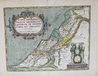
1606M8987Antwerp c.1606. Very Good. Notes: English text on verso. Size : 355x463 mm 13.98x18.23 Inches Coloring: Original Hand Coloring Reference: Van den Broecke 180. Category: Maps Asia Middle East Holy Land & Palestine; unknown
16556641Leyden: Apud Franciscum Hackium 1655. Full vellum. Very Good. 12mo. 860527pp. Index. Copper engraved title-page by Cornelis Cl. Dusand. Cont. vellum with yapped fore-edge a bit soiled. Repaired paper flaw on final text leaf and one leaf of index partially obscuring a few words. Ownership signature at top of front free endpaper dated 16 July 1703. See Willems 1185. Half of this edition was printed for Elzevir and has their imprint the other half was printed for Hackium. Apud Franciscum Hackium hardcover books
1631183832Lugduni Batav. Leiden. : Ex Officina Elzeviriana. 1631. 1st edition. Later early 19th century full red textured calf gilt title gilt ruled borders all edges gilt marbled endpapers ribbon marker. . Light shelfwear bookplates on endpapers otherwise a very good copy. 12mo. 12.7x7 cm. . Latin text. A travelogue through France in 1624-1626. Bookplate of Syston Park with the Thorold coat-of-arms on the pastedown. Small gilt and black label of Robert Hoe printing-press maker and book collector on the ffep. weight: 0.6 lb. Ex Officina Elzeviriana. unknown books
1601299086Antwerp: Abraham Ortelius 1601. unbound. Map. Engraving with beautiful original hand color. Image measures 14" x 18 3/4". Staining and toning to margins repair to lower centerfold but otherwise is good condition.<br/> <br/> Old color example of this lovely map of Valencia by Ortelius. The map extends from Murcia and Orihuella to the Cenia River and extending inland to include Aragon and Castilla. North is oriented to the right. Includes a beautifully designed strapwork cartouche and two large sailing vessels. Latin text verso. Abraham Ortelius 1527-1598 a Flemish cartographer and geographer is widely regarded as one of the important and influential cartographers in history. He is known for his "Theatrum Orbis Terrarum" which was the first modern atlas. Van den Broecke #30<br/> <br/> Abraham Ortelius unknown
1601299086Antwerp: Abraham Ortelius 1601. unbound. Map. Engraving with beautiful original hand color. Image measures 14" x 18 3/4". Staining and toning to margins repair to lower centerfold but otherwise is good condition.<br/><br/> Old color example of this lovely map of Valencia by Ortelius. The map extends from Murcia and Orihuella to the Cenia River and extending inland to include Aragon and Castilla. North is oriented to the right. Includes a beautifully designed strapwork cartouche and two large sailing vessels. Abraham Ortelius 1527-1598 a Flemish cartographer and geographer is widely regarded as one of the important and influential cartographers in history. He is known for his "Theatrum Orbis Terrarum" which was the first modern atlas. Van den Broecke #30<br/><br/> Abraham Ortelius unknown books
16421661642. Etching and engraving. Duplessis 1386; Blum 204 only state. Image: 10 x 12 with small margins. Foxing traces of old fold in the legend.
16421661642. Etching and engraving. Duplessis 1386; Blum 204 only state. Image: 10 x 12 with small margins. Foxing traces of old fold in the legend. books
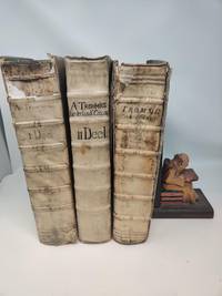
169184646Groningen and Amsterdam: Johannes Purmerent Gerardus Borstius 1691. First Edition. Vellum. Good. Three thick folios in vellum approx. 12x7 inches. <br /> <br /> 1: New Testament. Corners worn front hinge split but holds firm. Top half of rear hinge split one inch chip to head of spine covers soiled and smudged. Binding sound. 1036 pages. SIGNED by Abraham Trommius Groningen on page preceeding dedication. Printed by Johannes Purmerent in Groningen 1672. <br /> <br /> 2. Old Testament Vol 1 From Genesis to Esther. Published by Gerardus Borstius Amsterdam. 1685. Corners worn wear along bottom edges. Chip to bottom of spine top two inches of top of spine is flaked off but present. Covers soiled. Some wear to front pastdown text clean pages supple binding solid. 1242 88 pages. <br /> <br /> 3. Old Testament Vol 2: From Job to Malachi Published by Gerardus Borstius Amsterdam. 1691. Corners worn wear to extremities. Boards smudged and front board has some warping. Binding solid. Text clean pages supple. 984 1317 pages. Abraham Trommius 1633-1719 was a noted scholar and theologian and was the pastor at Groningen for 48 years. Johannes Purmerent, Gerardus Borstius unknown
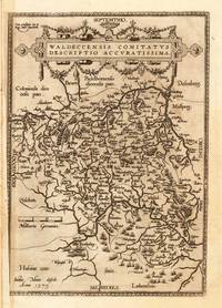
160811191Antwerpen: Juan B. Vrients 1608-12. In sehr gutem Erhaltungszustand. 31.3 x 223 cm 12.25 x 875 inches. Hand-Colored Original Copperplate Engraving by Abraham Ortelius depicting Waldeccensis Comitatus Descriptio Accuratissima. Published Antwerpen Juan B. Vrients 1608. Sheet: 31.3 x 223 cm 12.25 x 875 inches. A fine and original hand-colored example of Ortelius's celebrated cartographic work documenting this region of Germany with the precision and decorative artistry characteristic of the 16000s. Abraham Ortelius 1527-1598 was a Flemish cartographer and geographer from Antwerp widely regarded as the creator of the first modern atlas. His landmark publication Theatrum Orbis Terrarum 1570 set the standard for atlas-making for the next century presenting uniform copper-engraved maps with scholarly commentary. By Ortelius's death the Theatrum had appeared in 25 editions in seven languages. In 1575 King Philip II of Spain appointed him Royal Geographer. His maps engraved with extraordinary precision are among the most sought-after in antique cartography held in collections including the Plantin-Moretus Museum in Antwerp the Library of Congress and the British Library.This original copperplate engraving with original hand coloring depicts the region of Waldeccensis Comitatus Descriptio Accuratissima published in Antwerpen Juan B. Vrients 1608-12. The map records the political and geographic boundaries of the region as understood in 1608-12 offering a fascinating window into the history of German territorial organization. Sheet measures 31.3 x 223 cm 12.25 x 875 inches. In good condition overall with minor signs of age appropriate for a 17th-century engraving. Minor defects: centerfold as issued. Ready to frame. Broe. 98b; Juan B. Vrients unknown
16018057Antwerp Johann Baptist Vrients 1601. Copper engraving 8 x 11 cms recent hand-colour waterstaining in upper margin Latin text on verso. Zara and Sebinico on the Croatian coast from the second series of maps engraved for the Epitome by Philip Galle. Koeman Ort 58 Map unknown