145 résultats
173019575Um 1730. Ca. 12,5 cm x 31,5 cm.
175019504London,, um 1750. Ca. 35 cm x 43 cm (Platte), 42 cm x 50 cm (ganze Blatt).
1796621956Berlin, Voß, 1796. 1 Bl., VI, 466 S.; 1 Bl., 442 S., 1 Bl. Mit 20 (statt 21) Kupfertafeln, davon 1 gefaltet. Halbleder d. Zeit (beschabt u. bestoßen, Rücken unten mit Spuren entfernter Schilder). [2 Warenabbildungen]
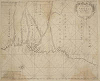
17611386<p>London: : From "The English Pilot: Part V" Sixth edition. Mount and Page 1761. 16-3/4" x 20-1/2"- 42.5 x 52 cm. Copper engraved map with hand colouring. Light overall browning with darker areas to corners generally good . An interesting coastal chart engraved by Francis Lamb showing rhumb lines from the Congo to Mount Negro in Mataman now Namibia.</p> From "The English Pilot: Part V" Sixth edition. Mount and Page,
1734164821London: W. Mears 1734. First Edition Thus . Hardcover. Very Good/No Jacket. 8vo - over 7¾" - 9¾" tall. Title continues: ". Containing a particular Account of all the Battles Sieges &c. Likewise a true Relation of the most secret Intrigues and Negotiations of the Courts of France Spain Germany and Savoy. Interpreted With Variety of entertaining Amours and original Letters of the several Princes concerned. Also The Political Intrigues of the late King of Sardinia containing an Account of the ill treatment of Mr. Phelippeaux the French Ambassador at the Court of Turin contrary to the Law of Nations. Translated from the Original French of Count Bonneval now in great Esteem at the Court of the Grand-Seignior By J. Sparrow Gent. With a correct Map explaining the Seat of the Last and Present War in Italy." 13 376pp; 1 folding map "Italy divided into Its Principal States" in excellent condition. Re-bound in modern brown Buckram with gilt dec. and spine titles. A very nice copy. <br/> <br/> W. Mears hardcover
1773797721773. unknown
171080848Crembs: Johann Jacob Kopitz 1710. kart. Johann Jacob Kopitz unknown
1792910854CGLondon:, Dilly und Robinson, 1792. Kupferstich 19 x 22,5 cm, Blattgröße 22 x 25,5 cm.
1783038539London: T. Cadell 1783. 1st Edition . No Binding. Very Good. A Fairly Detailed Map Of Africa The Surrounding Islands And The West Coast Of Arabia. 29 X 33 Cm. Folds; Some Light Browning. No Tears Or Chips. Removed From A Book. <br/> <br/> T. Cadell unknown
173057298ABNürnberg, Homann Erben, (nach, 1730). Plattengrösse:48x56,5 cm. Blattgrösse: 59,5x68 cm. Grenz- und flächenkolorierte Kupferstichkarte. Mittelfalz.
17301463BGo. O., o. J. [um 1730 - 1780]. Kupferstich. 37 x 54 cm. Im Passepartout., Abbildung
17811448BGo. O., o. Vlg., 1781. Kupferstich. 24 x 35 cm. Im Passepartout., Abbildung
1773797731773. unknown
1773652791773. kart. unknown
1798274639Londres L. Duprat-Letellier et Compagnie Paris 1798. Softcover 2 Bände 17981805. Zustand: Keine Beschädigungen keine Eintragungen. Rücken Ecken Kanten bestoßen berieben randrissig. Bei erstem Band Einband lichtrandig und Rücken mit Abschabung. Die Druckbögen sind unbeschnitten. In allem original. Mit Rückenkennung einer Klosterbibliothek. Londres + L. Duprat-Letellier et Compagnie, Paris, paperback
176431268ABBraunschweig und Wolfenbüttel, Johann Christoph Meißner, 1764. 16 Blätter, 232 S., 20 Bll. mit 2 gefalteten Karten (2 fehlende Blätter Inhaltsverzeichnis u. ein Blatt Druckfehler als Kopien beiliegend). Pappband der Zeit mit lose inl. Lesebändchen. Gestempelt u. nummeriert. Blätter gebräunt, Vorsätze u. teils die Ränder feuchtigkeitsspurig, ein Vorsatzblatt mit kurzem Einriss am Falz. Einband stark berieben u. bestossen, Rücken teils ohne Bezugspapier.
1762301756Tobias Lobeck G. Eichler Johann Michael Wagner Augspurg 1762. Hardcover Leder Die Jahresangabe ist ungefähr. Farbig Querformat kein Falz in der Mitte der Karten 15x11cm. Planispheirum und Weltkarten sind keine enthalten. Zustand: keine Beschädigungen keine Eintragungen. Rücken Ecken Kanten gut. Sauber Fleckenfrei. Tobias Lobeck, G. Eichler, Johann Michael Wagner, Augspurg, hardcover
17723123Halae: Ioannis Ioach. Beyery 1772. Gebunden. Ioannis Ioach. Beyery unknown
179010031ABLeipzig, Weygansche Buchhandlung, 1789-1790. 11.u.12. Tl in 1 Bd. 8°. VIII, 292 S. X, 312 S. 1 Kt. HLdr. 2 Rü.-Sch., verg. Rü.-Tit. u. Rü.-Verg. Etw. ber. u. bestossen. Biliotheksch. auf Rü.-geklebt. Einige Bll. l. gebr. Sauberes Expl.
17921308789Tübingen, J. Fr. Heerbrandt, 1791 - 1792. 4 Bl., 327, (1) S.; 2 Bl., 360 (von 364) S. Neuer Hlwdbd (fliegender Vorsatz m. Exlibris-Stempel, stellenweise gering braunfleckig, Tl 2 ohne die S. 361 - 364).
17531942Stadler: 9x15 cm 1753. Gebunden. 9x15 cm unknown
179129554Frankfurt 1791. Gebunden. unknown
177521527Paris 1775. Very good condition. Detailed copper engraved map of the east coast of Africa from the Saudi Arabia coast and the Red Sea down to Zanzibar. Many coastal cities and rivers named; the countries and regions named include: Costes d'Hasbach Zeila Ajan Muji Munni and Zanjibar sic. From Prevost's "L'Histoire Generale des Voyages".<br /> <br /> Bellin 1703 - 1772 one of the most noted French mapmakers of the 18th century was named the hydrographer chief cartographer to the French Navy and later the Official Hydrographer to the French King.<br /> <br /> With compass rose. Folding 8 x 10 1/8" with ample margins. Strong impression very clean. unknown
177521526Paris 1775. Very good condition. Detailed copper engraved map of the west coast of Africa from Sierra Leone and the Gulf of Guinee or St. Thomas down to Angola. Many coastal cities and rivers named; the countries and regions named include: Coste de Grain Coste d'Ivoire Coste d'Or Coste des Esclaves Benin Biafara Maiumbo Loango Congo and Angola. From Prevost's "L'Histoire Generale des Voyages".<br /> <br /> Bellin 1703 - 1772 one of the most noted French mapmakers of the 18th century was named the hydrographer chief cartographer to the French Navy and later the Official Hydrographer to the French King. <br /> <br /> With compass rose. Folding 10 x 8 1/8" with ample margins. Strong impression very clean. unknown
17643133AB[Paris], [ca.1764]. Blattgröße: ca. 23 x 18 cm. Grenzkolorierter Kupferstich auf Bütten. Kräftiger Druck, frischer Kolorit. Knapp am Plattenrand beschnitten. Recueil De Cartes Et Plans Des Quatre Parties Du Monde.