Clergyman of the Church of EnglandBiblio.com

5 854 résultats
137954677X.Ghardcover. Good. Access codes and supplements are not guaranteed with used items. May be an ex-library book. hardcover
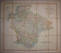
18286258London 1828. Copper engraving 49 x55 cms dissected into 15 sheets and laid on linen original hand-colour lifting slightly from backing without slip-case. Map unknown
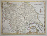
17607649London c.1760. Copper engraving 20 x 26 cms recent hand colour blank verso. Map unknown
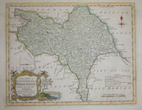
17607648London c.1760. Copper engraving 20 x 25.5 cms recent hand colour blank verso. Map unknown
2021DADAX1538146290Rowman & Littlefield Publishers 2021-03-01. hardcover. New. 6.38x0.80x9.45. Buy with confidence. Excellent Customer Service & Return policy. Rowman & Littlefield Publishers hardcover
2021SONG1538146290Rowman & Littlefield Publishers 2021-03-01. hardcover. Used: Good. 6.38x0.80x9.45. Buy with confidence. Excellent Customer Service & Return policy. Rowman & Littlefield Publishers hardcover
1937027479A&C Black: 1937. 376 pages illustrated with 4 maps and 3 illustrations with an Introduction by Sir Albert Gray. First published in London in the year 1697 this book was first published in 1927 by Argonaut Press and was limited to 975 copies. "Dampier's wonderful journal of what must surely be one of the slowest circumnavigations on record. Begun in the Spring of 1679 it soon became transformed into eight and a half years of promiscous buccaneering and piracy and copious scientific observations upon many branches of natural knowledge." FINE- HARDCOVER GOOD DUST JACKET. Dust jacket protected with a clear plastic acid-free jacket. Hard Cover. Fine-/Good. 4to - over 9¾" - 12" tall. A&C Black: Hardcover
0243078390.Gpaperback. Good. Access codes and supplements are not guaranteed with used items. May be an ex-library book. paperback
0483516635.Ghardcover. Good. Access codes and supplements are not guaranteed with used items. May be an ex-library book. hardcover
0428880258.Ghardcover. Good. Access codes and supplements are not guaranteed with used items. May be an ex-library book. hardcover
0526463708.Ghardcover. Good. Access codes and supplements are not guaranteed with used items. May be an ex-library book. hardcover
1147011842.Gpaperback. Good. Access codes and supplements are not guaranteed with used items. May be an ex-library book. paperback
1333650639.Gpaperback. Good. Access codes and supplements are not guaranteed with used items. May be an ex-library book. paperback
0364598131.Gpaperback. Good. Access codes and supplements are not guaranteed with used items. May be an ex-library book. paperback
0365095370.Ghardcover. Good. Access codes and supplements are not guaranteed with used items. May be an ex-library book. hardcover
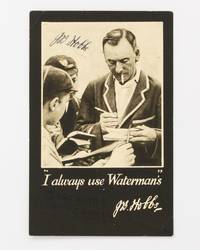
56483This unused albeit lightly foxed advertising postcard captioned '"I always use Waterman's" J.B. Hobbs' features a portrait of a late-vintage Jack Hobbs complete with blazer cigarette and Waterman's pen busily signing autographs for a couple of young lads. This example has been signed prominently in dark blue ink by Hobbs and the lad who received it has written - almost unnoticed in dark ink in the dark bottom margin - 'Jack Hobb's sic autograph'. unknown
2025__1509979670Hart Pub Ltd 2025. Hardcover. New. 2nd edition. 480 pages. 9.61x6.65x1.00 inches. Hart Pub Ltd hardcover
2025x-1509981144Hart Pub Ltd 2025. Hardcover. New. 3rd edition. 720 pages. 9.61x6.65x1.01 inches. Hart Pub Ltd hardcover
2000mon0004013502Hart Publishing 10/2/2025 12:00:01 A. hardcover. Very Good. 1.8504 9.8031 6.9685. Hart Publishing hardcover
1509947647New. Brand new and still unused unknown
2025SKU1742541Hart Publishing 2025-10-02. hardcover. New. 6x1x9. New Book Ships with Tracking Hart Publishing hardcover
20192-150992860XHart Pub Ltd 2019. Hardcover. New. 472 pages. 9.50x6.25x1.50 inches. Hart Pub Ltd hardcover
Bloomsbury-9781509947645Hart Publishing. Hardback. New. Hart Publishing hardcover
Bloomsbury-9781509947645Hart Publishing. Hardback. New. Hart Publishing hardcover
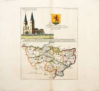
171757698History of Kent. c.1717. A delightful map showing the beacons of Kent above which there is a view of a church called the 'Reculvers in Kent'. Shield with dedication to Mr Richard Mount 'Citizen and Stationer of London Native of Kent'. Before accurate maps were available people used to navigate by prominent landmarks such as hills standing stones and later Church towers and spires. Hills were used for a vast communications network of fire beacons. This map was based on that by William Lambarde published in 1596 in his "Perambulation of Kent" called "A Carde of the Beacons in Kent". Lambarde's map was much criticised at the time for giving away state secrets. Copper engraving. Very good condition Hand coloured. Size: 45.5 x 36 cm. 18 x 14 inches unknown