MUSEE ROYAL DE BELGIQUEBiblio.com

1 577 résultats
184410896Imprimerie J. Stienon Brussels 1844. 12mo. title mildly spotted; handsomely bound in contemporary green full calf sides with double frame border in gilt surrounding an elaborate frame border comprising double rules stopped at corners by arabesques the whole enclosing the royal arms of Belgium including the lion of Brabant all in gilt back gilt extra with four flat bands ruled in gilt second compartment framed and lettered in gilt all other compartments framed in gilt all edges gilt gilt doublures gilt dentelles marbled silk endpapers a very good crisp copy in splendid royal binding of the period. A RARE SURVIVAL IN SPLENDID STATE. Imprimerie J. Stienon, Brussels, unknown
1991ZB3899751991-99. volumes 10-13 16-18; complete volumes partly bound ex library very good PRICE IS FOR THE LOT:. - If you are reading this this item is actually physically in our stock and ready for shipment once ordered. We are not bookjackers. Buyer is responsible for any additional duties taxes or fees required by recipient's country. Photos available upon request. unknown
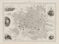
1851200135AG1851. London & New York John Tallis & Company 1851. Original steel engraving / Vintage map. Drawn and engraved by John Rapkin. Illustrated and Engraved by J. Watkins Plate Size: 32.5 cm x 26 cm. Sheet Size: 37.2 cm x 27.2 cm. Vintage 19th century map / city-plan in very good condition. Published in the Illustrated Atlas And Modern History Of The World Geographical Political Commercial & Statistical Edited By R. Montgomery Martin. Handsome town-plan of Brussels. The River Seine can be seen near the top of the map. Canals railway street and district areas of the city are also included. Decorative scrolling and title cartouche around the edges of the map. The project of 'The Illustrated Atlas' was designed to be finished just in time for the anxiously awaited "Great Exhibition of the Works of Industry of All Nations" or The Great Exhibition sometimes referred to as the Crystal Palace Exhibition in reference to the temporary structure in which it was held was an international exhibition that took place in Hyde Park London from 1 May to 11 October 1851. It was the first in a series of World's Fairs exhibitions of culture and industry that became popular in the 19th century and it was a much-anticipated event. The Great Exhibition was organized by Henry Cole and Prince Albert husband of the reigning monarch Queen Victoria. It was attended by numerous notable figures of the time including Charles Darwin Samuel Colt members of the Orléanist Royal Family and the writers Charlotte Brontë Charles Dickens Lewis Carroll George Eliot and Alfred Tennyson. Music for the opening was under the direction of Sir George Thomas Smart and the continuous music from the exhibited organs for the Queen's procession was "under the superintendence of William Sterndale Bennett". Wikipedia unknown
2021DBS-9781774076996ARCLER PRESS 2021. 1ST. Hardcover. New. ARCLER PRESS hardcover
2021DBS-9781774076996ARCLER PRESS 2021. 1ST. Hardcover. New. ARCLER PRESS hardcover
2021DBS-9781774077016ARCLER PRESS 2021. 1ST. Hardcover. New. ARCLER PRESS hardcover
2021DBS-9781774077016ARCLER PRESS 2021. 1ST. Hardcover. New. ARCLER PRESS hardcover
2021DBS-9781774077085ARCLER PRESS 2021. 1ST. Hardcover. New. ARCLER PRESS hardcover
2021DBS-9781774077085ARCLER PRESS 2021. 1ST. Hardcover. New. ARCLER PRESS hardcover
2021DBS-9781774077009ARCLER PRESS 2021. 1ST. Hardcover. New. ARCLER PRESS hardcover
2021DBS-9781774077009ARCLER PRESS 2021. 1ST. Hardcover. New. ARCLER PRESS hardcover
2021DBS-9781774077078ARCLER PRESS 2021. 1ST. Hardcover. New. ARCLER PRESS hardcover
2021DBS-9781774077078ARCLER PRESS 2021. 1ST. Hardcover. New. ARCLER PRESS hardcover
2020DBS-9781774071441ARCLER PRESS 2020. 1st. Hardcover. New. ARCLER PRESS hardcover
2020DBS-9781774071441ARCLER PRESS 2020. 1st. Hardcover. New. ARCLER PRESS hardcover
2020DBS-9781774071458ARCLER PRESS 2020. 1st. Hardcover. New. ARCLER PRESS hardcover
2020DBS-9781774071458ARCLER PRESS 2020. 1st. Hardcover. New. ARCLER PRESS hardcover
2020DBS-9781774071434ARCLER PRESS 2020. 1st. Hardcover. New. ARCLER PRESS hardcover
2020DBS-9781774071434ARCLER PRESS 2020. 1st. Hardcover. New. ARCLER PRESS hardcover
2020DBS-9781774071427ARCLER PRESS 2020. 1st. Hardcover. New. ARCLER PRESS hardcover
2020DBS-9781774071427ARCLER PRESS 2020. 1st. Hardcover. New. ARCLER PRESS hardcover
196841268Deinze: Kunst- en Oudheidkundige Kring Deinze 1968 - 2016. Jaarboeken XXXV-LXXXIII en 2 bijgevoegd. Samen 51 delen. Paperbacks. Eerste 29 delen 21x15 cm. de rest is 22x21 cm.; met illustraties. In goede staat. Zie foto. 'Kring voor geschiedenis kunst en erfgoed van Deinze en de Leienstreek' Bijgevoegd: 2 generaties beeldhouwers Antton en Luc van Parys & De Markt te Deinze Vroeger en nu. Kunst- en Oudheidkundige Kring Deinze paperback
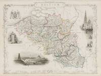
1851200102AG1851. London Edinburgh & Dublin J & F. Tallis 1851. Original steel engraving / Vintage map. Drawn and engraved by John Rapkin. Partly hand-coloured. Illustrations by J. Marchant and engravings by J.B. Allen. Plate Size: 34 cm x 26.3 cm. Sheet Size: 27.1 cm x 37.5 cm. Vintage 19th century map in very good condition. Published in the Illustrated Atlas And Modern History Of The World Geographical Political Commercial & Statistical Edited By R. Montgomery Martin. Beautiful and interesting map of Belgium from the Victorian Era. The political sub-divisions are shown on the map with provinces such as West Flanders Limburg and the Grand Duchy of Luxembourg included. The North Sea France Prussia and Holland all conspire to surround Belgium. The canal and railway systems are included on the map linking famous and historic cities such as Bruges and Ghent. The map is crowded with the names of towns and cities highlighting the population density of this much fought over part of the continent - known as the 'cockpit of Europe.' To the south and east the rugged topography - like that of the Ardennes - is depicted pictorially and through hachuring. John Tallis 7 November 1817 3 June 1876 was an English cartographic publisher. His company John Tallis and Company published views maps and atlases in London from roughly 1838 to 1851. Tallis set up as a publisher with Frederick Tallis in Cripplegate in 1842; the business moved to Smithfield in 1846 and was dissolved in 1849. From 1851 to 1854 Tallis operated as John Tallis and Company. He started The illustrated news of the world and national portrait gallery of eminent personages in 1858 selling it for £1370 in 1861; it folded in 1863. Wikipedia The most important project John Tallis undertook was the 'Illustrated Atlas' from 1851. The original map we offer here was part of this exceptional Atlas and all the maps it contained are still today considered as the last reminder of an era of lavish map production. Tallis worked the project together with John Rapkin 1815-1876 and it was Rapkin's style and talent that we have to thank for when we marvel at these maps today. What makes these maps so special is the detail of engraved vignettes that surround the map and often show indigenous scenes people in their environment and even more so historical buildings or historical views of towns and cities architecture and landscape. The project of 'The Illustrated Atlas' was designed to be finished just in time for the anxiously awaited "Great Exhibition of the Works of Industry of All Nations" or The Great Exhibition sometimes referred to as the Crystal Palace Exhibition in reference to the temporary structure in which it was held was an international exhibition that took place in Hyde Park London from 1 May to 11 October 1851. It was the first in a series of World's Fairs exhibitions of culture and industry that became popular in the 19th century and it was a much-anticipated event. The Great Exhibition was organized by Henry Cole and Prince Albert husband of the reigning monarch Queen Victoria. It was attended by numerous notable figures of the time including Charles Darwin Samuel Colt members of the Orléanist Royal Family and the writers Charlotte Brontë Charles Dickens Lewis Carroll George Eliot and Alfred Tennyson. Music for the opening was under the direction of Sir George Thomas Smart and the continuous music from the exhibited organs for the Queen's procession was "under the superintendence of William Sterndale Bennett". Wikipedia unknown
190856324London: A & C Black 1908. Thick 8vo. ix 3 390 pp. Colour frontisp. 76 colour plates numerous pen & ink text illusts. 1 folding sepia-tinted map. Black publisher’s cloth with lion rampant armorial in yellow ruling in yellow & orange on front cover gilt lettering on spine w/ light blue-green coloured d.j. pattern in blue NF/NF copy w/ beautiful bookseller’s label on front pastedown for Amand-Louis de Meuleneere Libraire in Brussels. First edition 1st printing 1 of 1000 copies with armorial printed in black rather than red in all subsequent printings of this lavishly illustrated travelogue through Belgium filled with history and local observations. Scarce in original dustjacket. Inman A&C Black Colour Books 5. A & C Black, hardcover
2005x-0415362237Routledge 2005. Hardcover. New. 1st edition. 263 pages. 9.25x6.25x0.75 inches. Routledge hardcover