Antiquariat.de

225 résultats
1914A111-190Wien, Kaiserlich-K?nigliches Milit?r-Geographisches Institut, 1914. Hochformat, ca. 38 x 55 cm, Ausgabe: mehrf?rbig; Zustand: gut +
1915A111-087Wien, Kaiserlich-K?nigliches Milit?r-Geographisches Institut, 1915. Hochformat, ca. 42 x 55 cm, , Ausgabe: mehrf?rbig; Zustand: gut +
1896K-2279Wien, Kaiserlich-K?nigliches Milit?r-Geographisches Institut, ca. 1896. Hochformat, ca. 38 x 55 cm, gefaltet zu 8 Segmenten, und auf Leinen aufgezogen Ausgabe: mehrf?rbig; Zustand: gut
1914A111-142Wien, Kaiserlich-K?nigliches Milit?r-Geographisches Institut, 1914. Hochformat, ca. 42 x 55 cm, Ausgabe: mehrf?rbig; Zustand: gut +
1914A111-200Wien, Kaiserlich-K?nigliches Milit?r-Geographisches Institut, 1914. Hochformat, ca. 42 x 55 cm, Ausgabe: mehrf?rbig; Zustand: gut +
1914A111-128Wien, Kaiserlich-K?nigliches Milit?r-Geographisches Institut, 1914. Hochformat, ca. 42 x 55 cm, Ausgabe: mehrf?rbig; Zustand: gut +
1906A131-648Wien, Kaiserlich-K?nigliches Milit?r-Geographisches Institut, 1906. Hochformat, ca. 38 x 55 cm, gefaltet zu 4 Segmenten Ausgabe: mehrf?rbig; Zustand: gut +
Very Good Turkish, Ottoman (1500-1928) Original color map on cloth. Oblong atlas folio. (49 x 60 cm). Toponyms in Turkish with Arabic letters. In Ottoman script. Scale: 1/25.000. [MAP of ISTANBUL / CONSTANTINOPLE] Küçükköy, Petnahor, Makriköy, Kagidhane [Kagithane]. A rare Istanbul map including some old Byzantine toponyms.
1915A111-089Wien, Kaiserlich-K?nigliches Milit?r-Geographisches Institut, 1915. 2. Ausgabe, Hochformat, ca. 38 x 55 cm, Ausgabe: mehrf?rbig; Zustand: gut +
1914A111-090Wien, Kaiserlich-K?nigliches Milit?r-Geographisches Institut, 1914. Hochformat, ca. 38 x 55 cm, Ausgabe: mehrf?rbig; Zustand: , gut +
1915A111-056Wien, Kaiserlich-K?nigliches Milit?r-Geographisches Institut, 1915. Hochformat, ca. 38 x 55 cm, Ausgabe: mehrf?rbig; Zustand: gut +
Very Good German Original color map on cloth. Chipped on folded places. Otherwise a clean copy. Oblong atlas folio. (46 x 52 cm). Scale: 1/300.000. Toponyms in German. Shows Gallipoli [and the Hellespont, Edremid Gulf, Imbros, Tenedos, Lesbos (Midilli), Aivali (Ayvalik) and North Aegean shores of Anatolia]. A sheet of the collection of 'The general map of Central Europe'. appeared in the years between 1873-1876 with the work of Joseph Ritter von Scheda, (1815-1888) who was a general, geographer and cartographer.
1838REIS0270aHildburghausen, Bibliograph. Institut (1838). quer 27,5x19,6 cm, Titel m. gestoch. Stahlstich (Prater), Index f. 2 Bände, 60 Stahlstichtaf. m. Seidenhemdchen u. Lieferungsbll., HLdr. d. Zt. m. gldgepr. Rückentit., berieb., Knickspuren am Einband, Ecken bestoß., RüKanten etw. rissig, marmor. Schnitt verstaubt, Tafeln vereinzelt stockig.
In 8, pp. 14 + (2b). Br. rifatta. Pubblicazione della canzone 'Il Danubio' dedicata alla vittoria conseguita da Leopoldo I contro i Turchi. La Guerra austro-turca duro' dal 1683 al 1699. Dopo la vittoriosa seconda battaglia di Mohács del 1687, l'obiettivo dell'esercito austro ungarico divenne Belgrado, la citta' fortificata alla confluenza della Sava con il Danubio, che era occupata dai turchi fin dal 1521. L'assedio ebbe inizio nell'agosto del 1688; la citta' fu presa dopo che entrambe le parti avevano subito enormi perdite.
Very Good Turkish, Ottoman (1500-1928) Original color map on cloth. Oblong atlas folio. (44 x 58 cm). Scale: 1/200.000. Toponyms in Ottoman script /Turkish with Arabic letters). Shows southwest of the Gallipoli Peninsula [and the Hellespont], Edremid Gulf, Tenedos, and North Aegean shores of Anatolia]. Folded. This is one of the series of the Bonn projection maps which are the first map series in modern techniques in Turkey and the Ottoman Empire. In order to produce these maps covering Turkish territory, Reconnaissance Branch was incorporated into The Mapping Commission. The maps were produced in the datum based on the latitude and longitude of the Ayasofya Mosque in equal area Bonn Projection. The field works for the 123 sheets covering the country were conducted by 76 staff. The production was completed in 18 years starting from east-west. Fieldworks continued without stopping except in the years 1914 and 1920. This map series called also reconnaissance maps contributed a lot to producing 1:25.000 scale maps. Hegira: 1336 = Gregorian: 1920. Not description on map-maker. Extremely rare.
2245A Paris, H. Mandeville, sans date. In-4 de XX-68 pages, pleine percaline violette d’éditeur, dos lisse, dos et plats richement ornés, tranches dorées. Dos passé, plats légèrement frottés.
In 8° (16,7x10,7 cm); (16), 482, (14) pp. e 6 tav. f.t., di cui 5 più volte ripiegate, incise su rame. Elegante legatura degli inizi del XX° secolo in cartoncino a motivi floreali in blu scuro e bianco e titolo in oro su fascetta al dorso. All'interno esemplare in perfetto stato di conservazione e ancora in barbe. Frontespizio in rosso e nero. Edizione più completa fra quelle uscite e non comune, di questa importante opera di interesse botanico, medico e farmacologico. Opera illustrata da 6 tavole, 5 a carattere botanico e una con due tavole in una carta: veduta di Donaueschingen la città tedesca nella parte sud-occidentale dello stato del Baden-Württemberg dove i fiumi Breg e Brigach si uniscono per formare il Danubio e una cartina entro cornice animata della stessa parte della Germania. L'opera contiene anche la Dissertatio medica de thee Elvetico (da c. 2D4r) e la Dissertatio de cymbalaria (da c. 2F6r). Johann Jakob Wepfer (23 dicembre 1620 - 26 gennaio 1695) fu un celebre patologo e farmacologo svizzero nativo di Schaffhausen. Studiò medicina a Strasburgo, Basilea e Padova, e nel 1647 tornò nella sua città natale per praticare l'arte medica. Fu anche un medico della famiglia reale. Wepfer è ricordato per il suo lavoro sull'anatomia vascolare del cervello, e i suoi studi sulle malattie cerebrovascolari. Fu il primo medico ad ipotizzare che gli effetti IMG_0138_clipped_rev_1di un ictus fossero il risultato di sanguinamenti del cervello. Arrivò anche ad ipotizzare che i sintomi dell'ictus potevano essere causati anche da un blocco di una delle arterie che normalmente forniscono sangue al cervello. Da studi post-mortem, ottenne importanti informazioni sulle arterie carotidee e vertebrali. Nel 1658 pubblicò un trattato che divenne presto un classico l'"Historiae apoplecticorum". Wepfer diede importanti contributi anche nel campo della farmacologia sperimentale e tossicologia. Condusse importanti esperimenti sulla tossicità della cicuta, dell'Helleborus e l'Aconitum mettendo in guardia anche contro l'uso dell'arsenico, dell'antimonio e del mercurio in medicina. Nel campo della farmacologia / tossicologia pubblicò nel 1679 questo lavoro qui presentato sulla cicuta e su altri numerose sostanze e piante velenose utilizzate in medicina che divenne ben presto un testo basilare per la storia della farmacologia e della medicina moderna. Bibl.: Haller I, 602; Seguier pt. 1, 210; Pretzel N. 10186. Modern binding but very good copy.
188312345Paris, E. Plon et Cie, 1883 ; in-4, demi-chagrin maroquiné rouge cerise à coins, dos à nerfs soulignés de filets à froid et dorés, caissons richement décorés et dorés, titre doré, doubles filets dorés sur les plats, tête dorée, non rogné (reliure de l’époque) ; (6), 412 pp. ; 10 planches en héliogravure et 1 carte dépliante en couleurs hors-texte, très nombreuses illustrations in-texte, 17 à pleine page.
In 8 gr., doppio front. (a stampa e inciso), p. VIII - 244, con 100 tav. f.t. incise e numerose ill. n.t., ottima leg. coeva in mz. pl. con tass. al dorso e carta impressa (lieve mancanza al piatto ant.); tagli colorati. Ediz. orig.
1748KART0099Nürnberg, Homanns Erben 1748. altkol. Kupferstichplan nach Nikolaus Visscher (1649-1702), Gesamtmaß: 60,5x 50,6 cm, Ansicht: 56,5x46,5 cm, in 24 Teilstücke zerschnitten u. auf Leinwand aufgezog., kartenmäßig gefalt., zwei kl. Stockfl. im ersten Segment, an den Schnittstellen tlw. etw. Die Donau von Klein Schöhnbühel bis Petronell mit Grundriss von Wien (im Zentrum der Karte), Ortschaften in Vogelschau, Berge bewaldet u. dunkler hervorgehoben.
84996Paris, Imprimerie Générale de Ch. Lahurie, 1866-1870, 1 volume de 250x320 mm environ, 133-109 pages, demi chagrin vert sapin, dos lisse portant titres et filets horizontaux dorés. Ex-libris sur la première garde de couleurs. Coins et coupes émoussés, rousseurs, petites déchirures sans manque sur certaines cartes dépliantes, sinon bon état.
184913354Paris, Mandeville, (1849) ; 2 tomes reliés en un volume in-4 ; demi-chagrin à coins vert foncé, caissons décorés et dorés, titre doré (reliure de l'époque) ; (8), XX, 68 pp. ; (4), VI, 102 pp. et en tout 64 gravures hors-texte en taille douce sur acier.
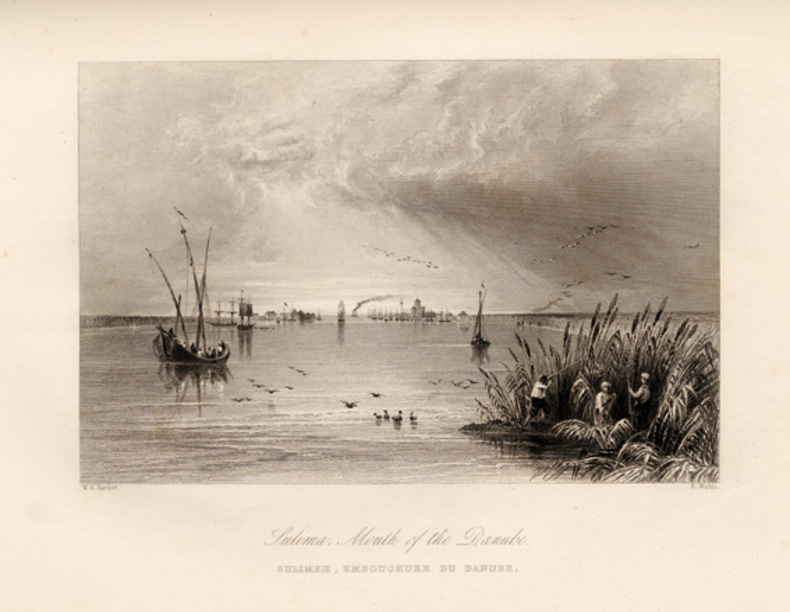
187447511Leipzig: F. A. Brockhaus 1874. First edition. Hardcover. vg- to vg. Elephant Folio. 6 leaves 60 Nos. I–LIX plus XXXIb plates two of them folding the others doubled-paged. Original three-quarter red morocco over green pebbled cloth tightened with twelve original metal pegs with gilt lettering and decor embossed medallion of cover gilt lettering and raised bands on spine. Marbled endpapers. <br /> <br /> Maps of the Danube delta and comparative plans of the mouth and of some river sections of the Soulina arm showing the last works which were carried out there by the European Commission according to the projects of Sir Chr. A. Hartley its leading engineer following the collection of comparative plans published by the commission in 1867. The commission of the Danube River Commission Européenne was authorized by the Treaty of Paris 1856 following the end of the Crimean War and is considered the most successful international commission to control the Danube Delta commerce. It was the precursor of the League of Nations the U.N. and the EU. This extensive atlas with detailed maps charts and technical plans was compiled by the Commission to present the regulations put in place at the Danube Delta between 1857 and 1867 the first decade of neutrality of the region. It contains a detailed folding map of the Danube delta 30 x 50" / 1:100000 rendered in color lithography as all plates showing ports Danube canals and their depth compared to Russian measurements of 1829. The second folding map also showing the Danube Delta and additional maps showing various parts of the delta and its distributaries in detail followed by charts and technical plans. All plates printed to double pages. <br /> <br /> Text in French. Binding with some wear bump at lower right corner closed tear at tail of spine with very light scuffing rubbed and very light soiling. Large map reinforced with brown tape on verso bleeding through and small 3 x 2/12/" taping on front with two and a half inch closed tear here. Light foxing of endpapers and first few pages. Brown spots on plates XXI through XVII barely affecting lithographs mostly at margins of five plates. Binding in overall good interior in very good- to very good condition. F. A. Brockhaus hardcover
1841002830Paris et Nancy, Tresse, et Chez Lauteur, 1841