HERSK Alex F.MareMagnum

225 résultats
In-8° gr. pp. VI-2-791 con 200 inc. di cui 25 sono tav. f.t. oltre alla carta del danubio divisa in 9 parti ripiegate f.t. Legatura in mezza pelle tipo ottocentesco con nervature e titolo al dorso. Conservata la bross. edit. illustrata.
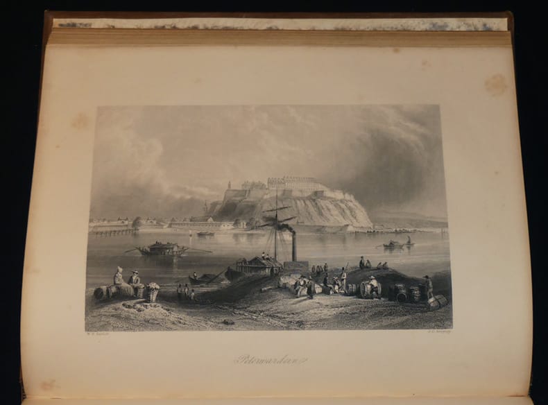
London, Richard Bentley, 1836, in-8 piccolo, cartonatura editoriale con titolo a stampa su tassello di carta al dorso (dorso che tuttavia è in gran parte mancante), pp. XVI, [1], 344. Con 10 tavole f.t. in litografia (9 vedute, antiporta compresa e una cartina del viaggio). Fra le sguardie anteriori è legato un catalogo editoriale di 12 pagine.
ws744Mandeville Reliure d'éditeur In-4 (21x27 cm), reliure cartonné de l'éditeur, dorures sur les plats et au dos, titre et tomaison dorés au dos, tranches dorées, XX + 68 pages, 32 gravures hors-texte, vues d'après nature dessinées par Bartlett, gravées par plusieurs artistes anglais, édition française revue par H.-L. Sazerac ; dos insolé, coiffes et coins frottés, une large mouillure au 4e plat, rousseurs à l'intérieur, assez bon état général. Livraison a domicile (La Poste) ou en Mondial Relay sur simple demande.
Illustration of horses pulling British soldiers in boats across the River Scarps. What a Bolshevist 'Peace' Means, by Lovat Fraser. 5 photos of Canadians homeward bound, their duty done. Quaint Quarters of the Fighting Men in France - 4 photos. 2 Photos of Shell-Smother Caught by the Camera. Trifles picked up on the blazed trail of war - 5 photos. Waiting for the opening offensive on the West. The True Story of Henry - by 'Vedette'. Illustration of an early version of the caterpillar tractor at work in Palestine. British mouth organ band in Palestine. Canine helpers in battle. A Serbian Supper-Party - some lively memories from the Lower Danube, by Hamilton Fyfe. Builders of the fleet that flies - 5 photos. Six great photos of Britannia, the Tank that rules the trenches. Photos of concrete vessels - can be built in a third of the time. Australia's Great Achievement - Heroic doings on land and sea, article with 6 photos. The Royal Fleet Auxiliaries, article by John S. Margerison. Average wear. Unmarked. Staples disintegrated. Sound copy. Book
This is a very good hardcover copy in a very good dust jacket of the first Greek edition. Completely clean inside and out. Dust jacket lightly toned. Text completely in Greek. This is the first Greek edition of Focas' work: 'The Lower Danube River in the southeastern European political and economic complex from antiquity' to the Conference of Belgrade of 1948, published in English in 1987. 30 black & white photographic plates. 10" high X 7" wide, 478 pages. Printed in Greece by Stavros Georgiadis, for the Institute for Balkan Studies, Serial No 144 Thessaloniki, October 1975. This book will be securely wrapped and packed in a sturdy box and shipped with tracking.
Very Good German Original color map on cloth. Chipped on folded places. Otherwise a clean copy. Oblong atlas folio. (46 x 52 cm). Scale: 1/300.000. Toponyms in German. Shows Saraybosna (Sarajevo), and its around, Travnik, Kladanj, G. Yakuf, Konjiva, Gorazda, Mostar et alli. A sheet of the collection of 'The general map of Central Europe'. appeared in the years between 1873-1876 with the work of Joseph Ritter von Scheda, (1815-1888) who was a general, geographer and cartographer.
Very Good German Original color map on cloth. Chipped on folded places. It needs repair. Oblong atlas folio. (46 x 52 cm). Toponyms in German. Shows Durach (Durazzo) and its around, Musakija at south, western shores of Albania, Elbasan, and three bays (Drin Golf etc). A sheet of the collection of 'The general map of Central Europe'. appeared in the years between 1873-1876 with the work of Joseph Ritter von Scheda, (1815-1888) who was a general, geographer and cartographer.
Very Good German Original color map on cloth. Chipped on folded places. Otherwise a clean copy. Oblong atlas folio. (46 x 52 cm). Toponyms in German. Shows Brood area and its around, Djakovo, Tuzla etc. A sheet of the collection of 'The general map of Central Europe'. appeared in the years between 1873-1876 with the work of Joseph Ritter von Scheda, (1815-1888) who was a general, geographer and cartographer.
Very Good German Original color map on cloth. Chipped on folded places. Otherwise a clean copy. Oblong atlas folio. (46 x 52 cm). Toponyms in German. Shows Krusevac and its around in Serbia. A sheet of the collection of 'The general map of Central Europe'. appeared in the years between 1873-1876 with the work of Joseph Ritter von Scheda, (1815-1888) who was a general, geographer and cartographer.
Very Good German Original color map on cloth. Chipped on folded places. Oblong atlas folio. (46 x 52 cm). Toponyms in German. [MAP of WEST WALLACHIA - CRAIOVA] N.10. Kraiova. A sheet of the collection of 'The general map of Central Europe'. appeared in the years between 1873-1876 with the work of Joseph Ritter von Scheda, (1815-1888) who was a general, geographer and cartographer.
Very Good German Original color map on cloth. Chipped on folded places. It needs repair. Oblong atlas folio. (46 x 52 cm). Toponyms in German. Shows Kastoria area in Greece. A sheet of the collection of 'The general map of Central Europe'. appeared in the years between 1873-1876 with the work of Joseph Ritter von Scheda, (1815-1888) who was a general, geographer and cartographer.
Very Good German Original color map on cloth. Chipped on folded places. Oblong atlas folio. (46 x 52 cm). Toponyms in German. A sheet of the collection of 'The general map of Central Europe'. appeared in the years between 1873-1876 with the work of Joseph Ritter von Scheda, (1815-1888) who was a general, geographer and cartographer.
184064193Wien, Hof- u. Staats-Aerarial-Druckerei, 1840. Fol. Titel m. Holzschn.-Wappen. 11 (1) S., Heftstreifen.
18634614Voyage dans la Forêt-Noire, la Bavière, l’Autriche, la Bohème, la Hongrie, l’Istrie, la Vénétie, et le Tyrol. Nombreux hors texte. 1/2 chagrin rouge, dos à nerfs orné de caissons dorés, tranches dorées. bon Tours Mame 1863 1 volume in-4°
331 pages. Topics include: They Who Mine the Ground; Richfield Miner; Lee Cheung; Cass Kilkot, Consulting Miner; Incident at the Dollar a Day Cabin; Long Bar; The Love Story of the Blue Danube and Yosephine; Rafe Oswik's Mine Shaft; The Lost Blue Grouse Gold Mine; The Bear Claim Cabin; Usual library markings. Modest wear. Tight and square. A sound copy. Book
196 pages. Translated from the German. Graphic black and white photos. "Renders an accurate account of the genocide of the Danube Swabian people living in Yugoslavia." - Editor's comment. Clean and unmarked with light wear. Binding tight. Book
Some browning/foxing to titlepage and light foxing to endpapers. Small crack just starting to rear hinge. Minor shelfwear to book. Dustjacket has 1 small tear and rippling to back panel (moisture? ). ; Contents: Augustus and the South Slav Lands; M. Vinicius (cos. 19 BC) ; Lentulus and the Origin of Moesia; Colony of Cornelius fuscus: an Episode in the 'Bellum Neronis'; First Garrison of Trajan's Dacia; Roman Senators from Dalmatia; Lower Danube under Trajan; Campaigns of Octavian; Vassal Tribes; Dacian Wars; Governors of Dacia; Governors of Pannonia; Governors of Dalmatia; Hadrian in Moesia; Legates of Moesia; Governors of Pannonia Inferior; Pliny and the Dacian Wars. ; Bibliotheque D'Etudes Du Sud-Est Europeen; 255 pages
1893K-2229Wien, Kaiserlich-K?nigliches Milit?r-Geographisches Institut, ca. 1893. Hochformat, ca. 38 x 55 cm, gefaltet zu 16 Segmenten, und auf Leinen aufgezogen Ausgabe: mehrf?rbig; Zustand: gut -, breiterer Rand mit Wasserflecken
1893K-2231Wien, Kaiserlich-K?nigliches Milit?r-Geographisches Institut, ca.1893. Hochformat, ca. 38 x 55 cm, gefaltet zu 16 Segmenten, und auf Leinen aufgezogen Ausgabe: mehrf?rbig; Zustand: gut -, breiterer Rand mit Wasserflecken
1893K-2275Wien, Kaiserlich-K?nigliches Milit?r-Geographisches Institut, ca.1893. Hochformat, ca. 38 x 55 cm, gefaltet zu 8 Segmenten, und auf Leinen aufgezogen Ausgabe: mehrf?rbig; Zustand: gut
Very Good Turkish, Ottoman (1500-1928) Original color map on cloth. Oblong eephant folio. (64 x 573 cm). Toponyms in Ottoman script. [MAP of BALKANS] Filibe [Plovdiv]. A very detailed map. Shows Plovdiv and mountains, rivers around it. Extremely rare.
1906A141-1270Wien, Kaiserlich-K?nigliches Milit?r-Geographisches Institut, 1906. Hochformat, ca. 38 x 55 cm, gefaltet zu 8 Segmenten, Ausgabe: mehrf?rbig; Zustand: gut +
1909K-1823Wien, Milit?rgeographisches Institut, 1909. Formatangabe ca 50 x 37 cm, gefaltet zu 8 Segmenten, auf Leinen aufgezogen mit aufkaschiertem Titel und Ma?stab und Legende auf je 1 Segmentr?ckseite, Ausgabe: einf?rbig ; Zustand: gut mit 2 Farbeinzeichnungen
1893K-2277Wien, Kaiserlich-K?nigliches Milit?r-Geographisches Institut, ca. 1893. Hochformat, ca. 38 x 55 cm, gefaltet zu 8 Segmenten, und auf Leinen aufgezogen Ausgabe: mehrf?rbig; Zustand: gut
1907K-1408Wien, Milit?rgeographisches Institut, 1907. Formatangabe ca 50 x 37 cm, gefaltet zu 10 Segmenten, auf Leinen aufgezogen mit aufkaschiertem Titel und Ma?stab und Legende auf je 1 Segmentr?ckseite, Ausgabe: einf?rbig ; Zustand: gut