55 résultats
188925246B1889. Buenos Aires: "Courrier de la Plata". 1889. 4°. 29 x 22 cm. 5081 p. Half cloth with handwritten label to spine. Rather worn. 2 stamps to title page and 1 stamp to last page paper some browning apart from this inside in good condition. ACHTUNG! Dieses Buch kann wegen seines Gewichts oder seiner Größe nur als PAKET verschickt werden. Innerhalb Deutschlands 580 Euro. Portokosten ins Ausland bitte erfragen. / ATTENTION! Due to its weight or size this book can only be sent as a PARCEL. Within Germany 580 Euro For shipment abroad please ask. hardcover
188925246BBuenos Aires:, "Courrier de la Plata"., 1889. 4°. 29 x 22 cm. 508,(1) p. Half cloth with handwritten label to spine. Rather worn. 2 stamps to title page and 1 stamp to last page, paper some browning, apart from this inside in good condition.
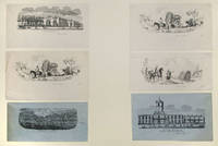
185522646Buenos Aires: R. Kratzenstein 1855. Lithographs measuring on average 3 1/2 x 6 1/2 inches on slips of blue or white paper likely clipped from the top of pictorial letter sheets. Light edge wear. Very good. Matted. An attractive group of lithographic vignettes of scenes in and around Buenos Aires.<br/> <br/> These images were published by Rodolfo Kratzenstein who was one of the leading lithographers in Buenos Aires from the mid-1850s and are probably from pictorial letter sheets issued by his firm in that period. One illustration shows a long stretch of the cityscape of Buenos Aires from the harbour and several ships are shown in the choppy waters of the port. Other images show the "Casa de Justicia" the courts and the "Palermo"neighborhood. Two other images one of them here in two examples show scenes in the countryside outside Buenos Aires both of them depicting men on horseback dealing with wagons in difficult terrain. Pictorial letter sheets from Argentina are uncommon and these are attractive images. R. Kratzenstein unknown
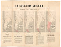
1878NL-02415<p><strong>Argentinian propaganda map of Chile's advance into Patagonia.</strong></p><p>This is an anonymous and undated propaganda map prepared by Argentina's Foreign Ministry for dissemination among potential allies on the American continents. It regards the conflict known as the "East Patagonia Tierra del Fuego and Strait of Magellan dispute" or "Patagonia Question" which was a territorial dispute between Chile and Argentina during most of the 19th century for more context see section below.</p><p>The sheet centers on five maps which are distinguished only by the varying size of the swathe of red that is meant to outline Chile's encroachment into Argentine Patagonia. The expansion process began in 1843 with only a few small islands and tiny peninsulas in the western part of the Strait of Magellan but by 1847 Chile was claiming the entire Strait as its own. The expansion continues in three subsequent phases each documented with its own map until 1876 when the territory in dispute consists of virtually all of Patagonia or the southern half of Argentina. Each of the intermediary stages in the quintet of displayed maps is dated and the territories in question are highlighted in red. Under each phase are noted the years in question as well as a brief explanation of the particulars of each phase of the expansionall of it from an Argentine perspective of course.</p><p>The Argentinian Foreign Ministry designed the map as a means of visualizing what Argentina considered the ongoing encroachment by Chile on Argentine territory. The broadsheet highlighted the blatant nature of Chilean territorial claims.</p><p>Because of this background and purpose the sheet was only distributed in limited circles making it a rarity today. The only institutional example of this map in the United States was presented to the US Minister to Argentina Thomas Ogden Osborn by the Argentine Minister of Foreign Affairs to serve precisely the purpose for which it was designed. The United States did indeed get involved and played a key role in the ensuing treaty negotiations 1879-1881.</p><p><strong>Census</strong></p><p>This sheet is rare likely because it was never produced in large quantities to begin with. There is only a single example of this sheet in US institutions. This document is located in the National Archives NAID: 5675669 and is the same sheet that Thomas Ogden Osborn sent to US Secretary of State William M. Evarts in 1880 following his role as US mediator in the negotiations for the 1881 Boundary Treaty that ended the conflict.</p><p>The only other institutional example we have been able to identify is held in the <em>Biblioteca Nacional de España</em> OCLC no. 431564806.</p><p><strong>Context is Everything</strong></p><p><em>The Strait of Magellan dispute and the "Patagonia Question" 18421881</em></p><p>The "Patagonia Question" was a nineteenth-century sovereignty dispute between Chile and Argentina over the southernmost lands of South America i.e. East Patagonia the Isla Grande de Tierra del Fuego and the strategically vital Strait of Magellan. Its roots lay in the messy inheritance of Spanish colonial jurisdictions and centuries of imprecise royal decrees that left overlapping claims along the entire Andean-to-Atlantic sweep. Both countries gradually sought to translate old legal claims into an effective national occupation: Chile concentrated on the Pacific channels and the Strait. At the same time Argentina pushed settlement eastward across the pampas and into Chubut.</p><p>Tensions hardened during the mid-1800s. Chile's deliberate occupation of the Strait of Magellan symbolized by the 1843 expedition that founded Fuerte Bulnes and formally took possession of the strait alarmed Buenos Aires and was the source of repeated diplomatic protests. Argentina in turn fostered new settlements established informal alliances with indigenous leaders and ensured a significant naval presence to assert influence on the Atlantic coast. By the 1870s both states were populating adjacent zones and commissioning maps and legal arguments to buttress their claims. This map is one such example from the Argentine side.</p><p>The trigger for a negotiated containment and ultimately a resolution of the conflict came in December 1878 when Chile and Argentina signed the FierroSarratea agreement. This was an interim pact that postponed a final delimitation and established arbitration procedures to avoid a fully fledged armed conflict. Chile quickly ratified the agreement but Argentina's Congress never gave its final approval causing it to collapse as a comprehensive settlement. The outbreak of the War of the Pacific 18791884 in which Chile fought Peru and Bolivia made rapid de-escalation with Argentina diplomatically urgent. Chile wished to avoid a second front. At the same time Argentina was engaged in the "Conquest of the Desert" on its southern frontier pushing it to resolve this old conflict as well.</p><p>The crisis was finally resolved by the <em>Boundary Treaty of 23 July 1881</em>. The treaty adopted a practical formula: north to the 52°S parallel the boundary would follow the highest Andes watershed; south of 52°S the agreement recognized Chilean sovereignty over the Strait of Magellan and assigned islands and Tierra del Fuego between the two states according to specified meridians and channels. Crucially the treaty neutralized the Strait of Magellan and guaranteed free navigation to all nations; a provision that allowed international passage through the strait and prevented any single power from controlling it.</p><p>US involvement in the dispute was modest. Washington did not act as an official guarantor or principal mediator in the 1881 settlement. However diplomatic records and dispatches confirm that the situation was under close observation and US diplomats regularly reported to their superiors on the crisis's development and its regional implications especially for shipping routes. Formal third-party arbitration and boundary adjudications were carried out by various state actors notably Britain or by various bilateral protocols. In short the U.S. was an interested observer rather than a decisive actor in both the dispute and its resolution.</p><p>The conflict illustrates how colonial legal ambiguities competing settlement policies and the strategic value of a single waterway combined to produce a long fraught boundary contest. The 1881 Boundary Treaty negotiated under the shadow of other regional wars and mediated by pragmatism rather than legality integrated competing claims into a workable frontier and ensured the neutrality of the Strait of Magellan for international shipping.</p><p>Condition Description</p><p>Good. Wear and toning along fold lines.</p> Foreign Ministry of Argentina
188517991Mendoza, Tip. Bazar Madrileno, 1885. 4°. Con muchas tablas, en parte plegadas. VII, 226 p. Media encuadernación de tela. Tres estampillas a la portada. La portada y escasas páginas con puntos de oxido.
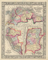
186046866New York: S. Augustus Mitchell Jr. 1860. Folio 12¼" X 15¼" image area 10½" X 13½". Hand colored. Near fine. Quite faint age toning. Bold bright and lovely map of these half dozen South American countries from the 1864 edition of "Mitchell's New General Atlas Containing Maps of the Various Countries of the World Plans of Cities Etc." Upper third contains "Map of New Granada Venezuela and Guiana" lower left third contains "Map of Peru and Equador" and lower right third contains "Map of the Argentine Confederation." Today "New Granada" consists of Colombia and Panama. Wonderfully delicately colored with fine decorative border. S. Augustus Mitchell, Jr. unknown
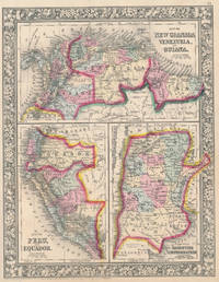
186046956New York: S. Augustus Mitchell Jr. 1860. Folio 12¼" X 15¼" image area 10½" X 13½". Hand colored. Very good. Mild age toning and bit of faint soiling. Quite nice map of these half dozen South American countries from the 1864 edition of "Mitchell's New General Atlas Containing Maps of the Various Countries of the World Plans of Cities Etc." Upper third contains "Map of New Granada Venezuela and Guiana" lower left third contains "Map of Peru and Equador" and lower right third contains "Map of the Argentine Confederation." Today "New Granada" consists of Colombia and Panama. Wonderfully delicately colored with fine decorative border. S. Augustus Mitchell, Jr. unknown
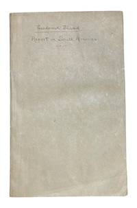
18199961Washington: Printed by E. de Krafft 1819. First edition. 8vo 147 1pp. Five folding tables. Bound in later plain paper wrappers with ms. title on front cover. Some browning to title else clean and very good. <br /> <br /> Very scarce house document which includes the report of two important surveys by Theodorick Bland 1776-1846 on Chile and Argentina. Bland was selected by President Monroe for a special diplomatic mission the South American Commission of 1817-1818. Several in the commission provided reports but most were strictly concerned with political military and commercial matters. These Bland's were different in that they were more fleshed out and provided more discussion on geography and agriculture. <br /> <br /> Sabin 5869. Printed by E. de Krafft unknown
188252900London & New York: Griffith and Farran West Corner of St. Paul’s Churchyard; E.P. Dutton & Co. May 1882. 12mo. 4 374 pp. plus 15 1 pp. publisher’s catalogue dated May 1882. Frontisp. 3 plates woodcut engraved head- and tail-pieces throughout. Dark green pictorial publisher’s cloth cover art illustration in black & gray of boy reading in tree gilt lettering 1 panel front cover 3 gilt panel titles on spine decorated endpapers bumping to corners minor rubbing & edgewear to head & foot of spine corners very light uniform interior toning still a VG- bright copy ownership inscription dated Christmas 82 on 2nd flyleaf. Early printing of one of Henty’s earliest adventure stories set against the backdrop of an English family pioneering in Argentina around the time of the Mexican-American War. Johann Baptist Zwecker 1814-1876 was a popular German artist who illustrated many different titles and magazines during the 19th-century including the illustrations for Alfred Russel Wallace’s Geographical Distribution of Animals. Griffith and Farran, West Corner of St. Paul’s Churchyard; E.P. Dutton & Co., hardcover