20 959 résultats
1795E0029<b>Samuel Hearne was the first European to make an overland excursion across northern Canada to the Arctic Ocean</b><br /><br />xliv458 pages with two of four engraved plates after drawings by the author both folding and four of five folding engraved maps. Quarto 11 3/4" x 9 3/4" bound in full leather with raised spine bands and gilt lettering to spine. HillI page 141. Sabin 31181 First edition.<br /><br />Manuscript journal was found by La Pérouse when he captured Fort Albany; later one of his conditions of surrender was that it be published. Samuel Hearne 1745 – November 1792 was an explorer fur-trader author and naturalist. He was the first European to make an overland excursion across northern Canada to the Arctic Ocean In 1774 Hearne built Cumberland House for the Hudson's Bay Company its first interior trading post and the first permanent settlement in present Saskatchewan. From 1769 to 1772 Hearne was employed in north-western discovery searching especially for certain copper mines described by Indians as "Far-Away-Metal River". These copper mines were found in the Barren Lands where the ground is permanently frozen to within a few inches of the surface creating in many areas vast stretches of mosquito- and fly-infested swamp during the summer thaw. For this reason it was decided that travel in winter was preferable. His first attempt began on 6 November 1769. The large size of the expedition and too much European equipment being carried led to the desertion of his Indian guides and the failure of the expedition. His second commencing 23 February 1770 failed because his quadrant was broken and much of his equipment was stolen. Learning from the mistakes of the first two expeditions Hearne contrived to travel as the only European with a group of Indians led by the great chief Matonabbee. The group also included eight of Matonabbee's wives to act as beasts of burden in the sledge traces camp servants and cooks. This third expedition set out in December 1770 in order to reach the Coppermine River in summer by which he could descend to the Arctic in canoes. Matonabbee kept a fast pace so fast they reached the great caribou traverse before provisions dwindled and in time for the spring hunt. Here all the Indian hunters of the north gathered to hunt the vast herds of caribou migrating north for summer. A store of meat was laid up for Hearne's voyage and a band of warriors joined the expedition. Matonabbee ordered the women to wait for his return in the Athabasca country to the west. The Chipewyans were generally a mild and peaceful people however they were in a state of conflict with the Inuit. A great number of Indians joined Hearne's party to accompany them to the Coppermine River with intent to murder Inuit who were understood to frequent that river in considerable numbers.2 On July 14 1771 they reached the Coppermine River a small stream flowing over a rocky bed in the "Barren Lands of the Little Sticks". A few miles down the river just above a cataract were the domed wigwams of an Eskimo camp. At 1am on July 17 1771 Matonabbee and the other Indians fell upon the sleeping Eskimo in a ruthless massacre. Approximately twenty men women and children were killed; this would be known as the Massacre at Bloody Falls. A few days later Hearne was the first European to reach the shore of the Arctic Ocean by an overland route. By tracing the Coppermine River to the Arctic Ocean he had established there was no northwest passage through the continent at lower latitudes. This expedition also proved successful in its primary goal by discovering copper in the Coppermine River basin. However an intensive search of the area yielded only one four-pound lump of copper and commercial mining was not considered viable. Matonabbee led Hearne back to Churchill by a wide westward circle past Bear Lake in Athabasca Country. In midwinter he became the first European to see and cross Great Slave Lake. Hearne returned to Fort Prince of Wales on 30 June 1772 having walked some 5000 miles and explored more than 250000 square miles.<br /><br />Condition:<br /><br />Rebound in attractive leather with raised spine bands. Lacks frontispiece map and two plates. Plate I A North West View of Prince of Wales's Fort and Plate IV A Winter view of the Athapuscow Lake. Some internal spotting. Small repair to title page and verso and front free end paper edge else a better than very good copy. Printed for A Strahan and T Cadell hardcover books
1795E0029<b>Samuel Hearne was the first European to make an overland excursion across northern Canada to the Arctic Ocean</b><br /><br />xliv458 pages with two of four engraved plates after drawings by the author both folding and four of five folding engraved maps. Quarto 11 3/4" x 9 3/4" bound in full leather with raised spine bands and gilt lettering to spine. HillI page 141. Sabin 31181 First edition.<br /><br />Manuscript journal was found by La Pérouse when he captured Fort Albany; later one of his conditions of surrender was that it be published. Samuel Hearne 1745 – November 1792 was an explorer fur-trader author and naturalist. He was the first European to make an overland excursion across northern Canada to the Arctic Ocean In 1774 Hearne built Cumberland House for the Hudson's Bay Company its first interior trading post and the first permanent settlement in present Saskatchewan. From 1769 to 1772 Hearne was employed in north-western discovery searching especially for certain copper mines described by Indians as "Far-Away-Metal River". These copper mines were found in the Barren Lands where the ground is permanently frozen to within a few inches of the surface creating in many areas vast stretches of mosquito- and fly-infested swamp during the summer thaw. For this reason it was decided that travel in winter was preferable. His first attempt began on 6 November 1769. The large size of the expedition and too much European equipment being carried led to the desertion of his Indian guides and the failure of the expedition. His second commencing 23 February 1770 failed because his quadrant was broken and much of his equipment was stolen. Learning from the mistakes of the first two expeditions Hearne contrived to travel as the only European with a group of Indians led by the great chief Matonabbee. The group also included eight of Matonabbee's wives to act as beasts of burden in the sledge traces camp servants and cooks. This third expedition set out in December 1770 in order to reach the Coppermine River in summer by which he could descend to the Arctic in canoes. Matonabbee kept a fast pace so fast they reached the great caribou traverse before provisions dwindled and in time for the spring hunt. Here all the Indian hunters of the north gathered to hunt the vast herds of caribou migrating north for summer. A store of meat was laid up for Hearne's voyage and a band of warriors joined the expedition. Matonabbee ordered the women to wait for his return in the Athabasca country to the west. The Chipewyans were generally a mild and peaceful people however they were in a state of conflict with the Inuit. A great number of Indians joined Hearne's party to accompany them to the Coppermine River with intent to murder Inuit who were understood to frequent that river in considerable numbers.2 On July 14 1771 they reached the Coppermine River a small stream flowing over a rocky bed in the "Barren Lands of the Little Sticks". A few miles down the river just above a cataract were the domed wigwams of an Eskimo camp. At 1am on July 17 1771 Matonabbee and the other Indians fell upon the sleeping Eskimo in a ruthless massacre. Approximately twenty men women and children were killed; this would be known as the Massacre at Bloody Falls. A few days later Hearne was the first European to reach the shore of the Arctic Ocean by an overland route. By tracing the Coppermine River to the Arctic Ocean he had established there was no northwest passage through the continent at lower latitudes. This expedition also proved successful in its primary goal by discovering copper in the Coppermine River basin. However an intensive search of the area yielded only one four-pound lump of copper and commercial mining was not considered viable. Matonabbee led Hearne back to Churchill by a wide westward circle past Bear Lake in Athabasca Country. In midwinter he became the first European to see and cross Great Slave Lake. Hearne returned to Fort Prince of Wales on 30 June 1772 having walked some 5000 miles and explored more than 250000 square miles.<br /><br />Condition:<br /><br />Rebound in attractive leather with raised spine bands. Lacks frontispiece map and two plates. Plate I A North West View of Prince of Wales's Fort and Plate IV A Winter view of the Athapuscow Lake. Some internal spotting. Small repair to title page and verso and front free end paper edge else a better than very good copy. Printed for A Strahan and T Cadell hardcover
17200101766London: printed for D. Browne at the Black-Swan etc. 1720. Leather Bound. pp. 4 304. 8vo. Full leather binding in Cambridge style with an expertly rebacked spine. Leather title labels lettered in gilt 5 raised bands. Ink spill to foredge of 50 pages. "An account of the expedition of 1711 by its leader written as a reply to criticisms of his conduct of the unfortunate affair" - Sabin 101050. TPL 148. With leather bookplate of W A William Alfred Westropp Foyle Beeleigh Abbey: who along with his brother founded the iconic eponymous London bookshop; and a second bookplate featuring a lion and unicorn with only "Libertas No 3494 printed for D. Browne at the Black-Swan, etc. unknown
17788670Paris, de l'Imprimerie Royale, 1778. 2 volumes in-4 de [4]-389-[1]-XIX-[3]; [8]-500-XXXII pages, plein veau marbré brun, dos à nerfs ornés de filets et fleurons dorés, pièces de titre en maroquin rouge, tranches mouchetées, petits accrocs aux coiffes supérieures, épidermures, coupes et coins frottés, tampon sur les pages de titre, quelques pâles rousseurs.
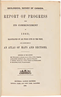
1906WRCAM50950Montreal Toronto Quebec & Ottawa 1906. Seventy-seven works including numerous maps. Some original wrappers some volumes in contemporary leather bindings some in later yellow buckram. Some map volumes supplied at least in part in facsimile. Overall very good. A long run of the geological survey of Canada with some works printed in English and some in French. Comprises the progress reports and maps for the Canadian geological survey for a period of about fifty years. Includes the rare large folio atlas PLAN OF VARIOUS LAKES AND RIVERS BETWEEN LAKE HURON AND THE RIVER OTTAWA. Toronto 1857 listed as numbers 16-38 in Ferrier's ANNOTATED CATALOGUE.OF THE GEOLOGICAL SURVEY CANADA. The atlas is usually encountered in quarto format with the maps folded to conform to the smaller size. A copy of the Ferrier bibliography is also included with the collection. A complete detailed list of the works is available upon request. hardcover books
190338161Washington D.C.: Privately printed 1903. 11 x 8 1/2 inches. 29 leaves of text printed double-column on rectos only with occasional manuscript ink corrections; 62 mounted photographs mostly 3 1/2 x 4 1/2 inches facing text on versos of printed leaves or on separate thicker paper. Original red ribbon tied green printed green wrapper.<br/> <br/>Likely privately printed account of an August 1903 camping and fishing trip into Canada's Muskoka region by fourteen people from the Indian Territory Arkansas Mississippi Kentucky Tennessee Washington DC and Northampton and Boston Massachusetts.<br/> <br/>Hosted by Major Breckenridge this trip was a follow-up to a 1902 trip ruined by bad weather and other problems and cut short. This 1903 trip was better organized and with a larger party. The group assembled at a cottage on Lake Rousseau north of Toronto and took canoes to camps on Lakes Blackstone and Crane near Parry Sound. The first four chapters relay descriptions of their travels camping gear fishing tackle boats the scenery local farms and preparations for various activities among many other details. The final chapter of the book "August 1903" was written by Mary Breckenridge and provides a detailed account of the fishing: "We now had a plentiful supply of fish. Luck was good for nearly everyone.to the major rested the honor of the largest fish a wall-eyed pike with a really ferocious countenance." The photographs closely track the narrative with the images reflecting the text opposite and show docks and buildings along the traveled routes scenes of the Canadian backwoods camps and members of the party engaged in various activities including swimming boating fishing cooking etc. Major Breckeridge wished to "provide a trip which would make his girls permanent lovers of fishing and camping and willing companions of his future expeditions for.none are too tender to cultivate the angler's art." He bought a small number of maple leaf pins which he distributed to the party and which became the badge of the Maple Leaf Club. Privately printed unknown books
elala6217Toronto: M.Reynolds Printer to the Hon. the House of Assembly 1835. First Edition of this famous report an eloquent and forceful indictment of the Family Compact Government largely written by Scottish-Canadian journalist and politician William Lyon Mackenzie who chaired the committee. The grievances of the Reformers are listed in detail: concern regarding the excessive power of the executive branch in Upper Canada and the campaigning of government officials for Tory politicians during elections criticism of companies like the Welland Canal Company that mismanaged funds given to them by the government and the salaries of officials who received patronage appointments. Demands are made for an elective legislative council and responsible government. A landmark document in the political history of Upper Canada. Mackenzie represented York County in the Legislative Assembly of Upper Canada and was elected the first mayor of Toronto in 1834. He led the rebels in the Upper Canada Rebellion in 1837 and after its defeat he unsuccessfully rallied American support for an invasion of Upper Canada as part of the Patriot War against British imperialism. Interestingly this is a signed presentation copy given the year of publication by lawyer politician and later judge Archibald McLean who was a rising member of the Family Compact. As a colonel of the militia during the 1837 rebellion he was involved in routing the rebels in Toronto commanding the left flank of the loyalist forces under Colonel James Fitzgibbon in the attack on Montgomery’s Tavern. Fleming 892. Gagnon I 2196. Lande 859. Sabin 10577. TPL 1929. Watters p. 885. 8vo. pp. 6 p.l. 76index 2errata li 1 372 vi 26 A-I K-Y. with half-title. A very good copy in original cloth-backed bds. paper spine label chipped. Signed Presentation copy dated 1835 to Dr. Alexander Wylie Matilda from his friend Archibald McLean M.P.P. 1791-1865. elala6217 Toronto: M.Reynolds, Printer to the Hon. the House of Assembly, 1835 hardcover
elala5931Kingston: 1865. Reading: “I have done what I could and have not yet been able to persuade Council to dispose of the matter. I will try again when we re-assemble at Ottawa.you will have early opportunities of seeing Alexander Tilloch Galt Minister of Finance with whom the initiative in money matters rests.â€. Over the course of many years MacDonald supported George Herman Ryland Registrar of Montreal and former Clerk of the Executive Council for the Province of Lower Canada in his efforts to obtain financial compensation from the government. Ryland’s claim was based on a promise made to him by Lord Sydenham the first Governor-General of the United Province of Canada 1841. At the time Macdonald was attorney-general for Canada West. 8vo. pp. 2 p.l. with integral blank horizontal & vertical folds. elala5931 Kingston: 1865 unknown
elala5933Toronto: 1856. Reading: “I enclose you the Duke of Argyll’s letter – and am glad to learn that there is some prospect of your long standing claims being adjusted. I shall take an early opportunity of enquiring as to the appt. of the other arbitrators.†Over the course of many years MacDonald supported George Herman Ryland Registrar of Montreal and former Clerk of the Executive Council for the Province of Lower Canada in his efforts to obtain financial compensation from the government. Ryland’s claim was based on a promise made to him by Lord Sydenham the first Governor-General of the United Province of Canada 1841. At the time of this letter Macdonald was attorney-general for Canada West. George John Douglas Campbell 8th Duke of Argyll a British Liberal politician who served as Lord Privy Seal 1852 and 1855 in the cabinet of Lord Aberdeen and then as Postmaster General 1855-58 in Lord Palmerston’s first cabinet was a leading supporter of Ryland’s case for financial compensation from the British Government. His son the 9th Duke best known as Marquess of Lorne was Governor-General of Canada from 1878 to 1883. 8vo. pp. 1 with integral blank. horizontal & vertical folds. With initialed cover with seal & note mentioning an enclosure from the Duke of Argyll which is not present. elala5933 Toronto: 1856 unknown
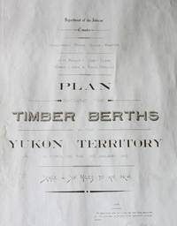
191030781<p>N.p. 1910 Large manuscript map measuring 40 x 103 ¾ inches pen and ink with pencil additions on drafting linen some minor soiling to edges else in very good clean condition.</p><p>Large scale manuscript map which delineates the territory from Skagway portions of British Columbia the Yukon and Klondike Country as far north as the Porcupine River. The map shows the rivers creeks settlements rail roads N.W.M.P. barracks timber berths and reserves.</p>
191030781<p>N.p. 1910 Large manuscript map measuring 40 x 103 ¾ inches pen and ink with pencil additions on drafting linen some minor soiling to edges else in very good clean condition.</p><p> Large scale manuscript map which delineates the territory from Skagway portions of British Columbia the Yukon and Klondike Country as far north as the Porcupine River. The map shows the rivers creeks settlements rail roads N.W.M.P. barracks timber berths and reserves. </p> books
1916346H5199New York: The International News Company 1916. Book. Illus. by Somerfield Thomas; Pride Sid; Holloway W.H.; Gillett Frank; Evison G.H.; Pitcher Sotheby; Prater Ernest. Good. Single Issue Magazine. First Edition. 8vo - over 7¾" - 9¾" tall. Abundant black and white illustrations and reproductions of photos. Features: Two Men's Madness - six lives and a fine ship the Frank N. Thayer are lost through the unaccountable frenzy of two Indians; In Wildest Ireland - A.W. Cutler describes and photographs "unspoilt" regions of the Emerald Isle - with many fascinating photos; The Guardian of the Line - the ordeal undergone by a humble railway-crossing keeper's wife in Lithuania on the Russian Front; In Search of the Unknown Land - The tragic story of the Stefansson Arctic Exploration Expedition twelve-page article including many photos; The Tales of Golab Khan - some amusing stories of Indian life; The Airman's Escape - two British aviators raid a Bulgarian town then one is shot down and must be rescued by his companion; From Job To Job Around the World - part VI - Two American wanderers make there way through the Holy Land to Constantinople - with photos; The Trouble at Crib No. 2 - a tug-boat fireman recounts an exciting story of a winter rescue on the Great Lakes; Australia's Water Miracle - article and photos describe how the Government of New South Wales has created a miracle of irrigation; The Story of Count Seilern - A Tragedy of the Hapsburgs; Alpine Acrobats - A vivid account illustrated by some very remarkable photographs of the first ascent of the needle-like "Cigar Rock" in the Italian Alps; Lovely one-page illustrated ad by Canada Steamship Lines promotes their Niagara to the Sea all-water route; and more. pp. 4 ads 3 290-385 7-32 ads. Unmarked with moderate wear. Soiling to back cover. Covers beginning to loosen otherwise a sound vintage copy of this exceptional issue. The International News Company Paperback
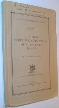
1914724a7836Victoria BC: Government of British Columbia B.C. 1914. Book. Good. Paperback. First Edition. 8vo - over 7¾" - 9¾" tall. 69 pages. Complete with 8 protected map plates. Signed and inscribed by E.O.S. Scholefield Archivist of British Columbia atop front cover. Pages 3-4 constitute a letter of submittal by Mr. Scholefield to the Honourable Henry Esson Young Provincial Secretary. This work "represents the first bulletin of the British Columbia Provincial Archives Department." - page 3. "Vindicates the contention of Captain Vancouver that his ships were the first to complete the navigation of the inner channels which separate Vancouver Island from the British Columbia mainland." - M. Menzies. Errata neatly affixed to verso of Map List. Map plate V loose but present. Rough cut edges. Contents clean unmarked and lightly toned. Short openings to bottom edges of beige card covers. Strathern 399. Government of British Columbia (B.C.) Paperback
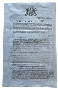
184344013Toronto 5th of June: Canada Company Office Frederick Street 1843. folio. 31cm 4 pages folded on light weir tinted blue paper in mint condition very rare. mint. Being Twenty-One numerated questions with detailed paragraph answers concerning emigration. Subjects include costs wages crops climate society etc. taxes transportation . T.P.L. 2571 "The memorandum describes the land of the district facilities for settlement and cultivations also costs". In 1843 the Canada Company led by commissioner Frederick Widder issued publications to address numerous inquiries from British North America and the United States regarding settlement in Canada West formerly Upper Canada. These documents often featuring memos from local agents provided information on land in the Huron Tract and assisted in advising prospective emigrants on farming opportunities. Key details about the Canada Company around 1843: Active Promotion: The company was actively answering questions to boost immigration to the Huron District which contained about one million acres of land. Frederick Widder was a key figure having been appointed co-commissioner in 1839 leading to improved efficiency in the company's operations. By 1843 the company was operating more effectively following the Act of Union 1841 and was in the process of paying off its debt to the British. Various documents from 1843 and 1845 were published to promote the thriving towns such as Guelph and the surrounding Wellington District. Canada Company Office, Frederick Street unknown
16245New-York, Brentanos, 1944. In-8, 176 pp., couverture originale imprimée en couleurs, non coupé (petites traces de pliure et déchirures à la couverture).
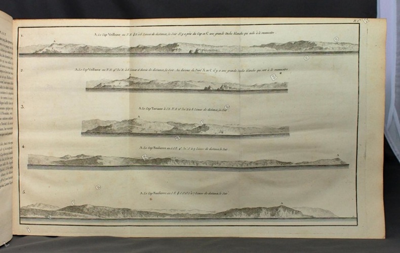
Incisione in rame (mm. 497x570) su doppio foglio con bellissima colorazione coeva, verso velato da finissimo foglio di carta Giappone. Bella e rara carta nautica, tratta dal celebre atlante di De Witt ''Orbis Maritimus ofte Zee Atlas", mostra alcune delle prime mappe provvisorie della regione. Basato sulla precedente carta di Van Loon del 1666, raffigura l'America settentrionale, la baia e lo stretto di Hudson, la baia di Baffin, un'isola di Baffin allargata, la baia di James e la baia di Buttons, l'Isola di Terranova e, attraverso il mare, fino alla costa occidentale della Groenlandia. Interessante l'indicazione, in basso, nell'istmo tra la Baia di James e quella di Great, "Hic hibernavit Hudson". Rosa dei venti, linee lossodromiche e una battaglia navale nei pressi dello stretto di Hudson. Scale metriche in miliaria gallica e miliaria tedesca. Riccamente impreziosito da due elaborati cartigli, uno in latino e uno in olandese, decorati da indigeni e colonizzatori, intenti in scambi commerciali. L'abile rinforzo con carta Giappone evita il deperimento da acidità ai verdi e marroni; quindi l'esemplare si presenta in ottimo stato, anche grazie alla splendida coloritura del cartiglio. "Frederick de Wit deve essere considerato uno dei più importanti editori di mappe della seconda metà del XVII secolo. La maggior parte delle sue mappe sono di ottima qualità, sono caratterizzate da un'incisione chiara e bella, dall'attualità e ricchezza dell'immagine cartografica nonché dall'equilibrio delle decorazioni cartografiche". (Lexikon der Kartographie II, p. 899), Koeman M. Wit 1, 27. Koeman, Atlantes Neerlandici, IV, pp.191 e 518-519. Shirley 444. Putnam, Early sea charts, 75.. .
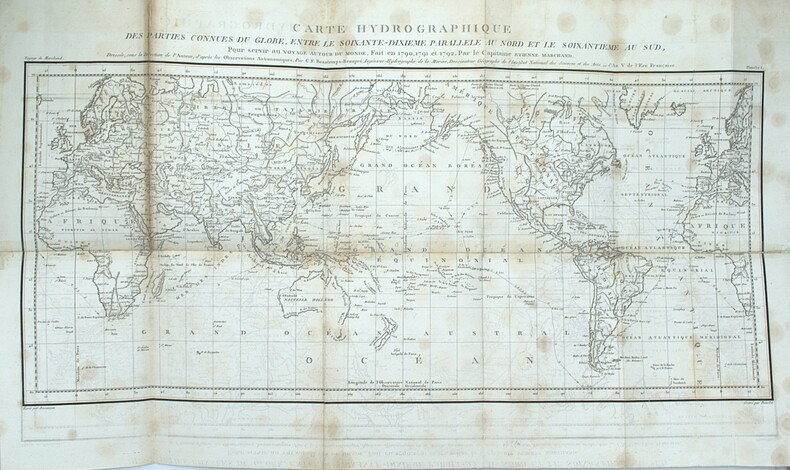
1798PHO-2367Paris, De l’Imprimerie de la République, An VI-An VII [1798-1799]. Texte : 5 volumes in-8 (22,5x14cm), 1f.-CCI-1f.-294pp.-1f., VII-529pp. (3 tableaux dépliants), VIII-474pp.1f. (8 tableaux dépliants), VIII-494pp., XII-559pp.-2ff., relié toile moderne, pièce d’auteur, titre et tomaison, non rogné, mouillure. Atlas : 1 vol. In4° (4) (26,5x22cm), VIII-158pp.-1f., 15 cartes et 1 gravure. Demi veau, titre et tomaison au dos, frottements, coins usés, accroc au dos, charnière fendillée, piqures sur quelques feuillets et cartes, renforcement et réparation sur 1 carte, la carte 15 en fac-similé Rare édition in-8, parue en même temps en format in-4, accompagné de l’atlas correspondant au tome 4 de l’édition in-4.
First edition. Original boards. 8vo. 210 pages; 188+36 pages; 140+41 pages; 256 pages; 145 +26+14 pages. 23 cm. In Hebrew. First full printing of the Zohar in North America. Title translates to The Zohar: The Zohar Interpretation of the Torah. The translation work was done by one of Canadas prominent rabbis, Yehudah Yudl Rozenberg. Rabbi Rozenberg (18591935) was a very prominent Polish rabbi who wrote extensively on the Talmud, Torah, Kabbalah, and other aspects of Jewish life. This translation was a monumental achievement and was commended by the likes of Rav Kook and Rabbi Margolis. He is considered the originator of many aspects of the Golem legend, which he wrote about in The Maharal and the Golem. ) Brody, SUBJECTS: CABALA KABBALAH. OCLC lists 14 copies worldwide, and only one in Canada (UOttawa) . Ex-library with usual markings. Backstrip rebacked with tape. Boards are minorly edgeworn. Overall Good Condition. (HEB-50-16)
175614384A Amsterdam, et se trouve à Paris, chez Duchesne, 1756. In-12 de XLVII-(1)-352 pp., veau marbré, dos lisse orné, pièce de titre en maroquin noir (reliure de l'époque).
432 pages. Index. Biographical Notes. List of Abbreviations. Chart. Tables. Fourteen reproductions of black and white photos in text. Color map of Canada, Alaska and Greenland stored in back pocket. Describes in detail how Canada and the United States joined to thwart the Axis threat and stresses the very significant work of the Permanent Joint Board on Defense, Canada-United States. Inside front board a 9.25" x 6.25" typed presentation letter, dated 16 February 1960, to Lieutenant General Samuel Findlay Clark, Canadian Army, is signed by L.L. Lemnitzer, Chief of Staff of the United States Army. Letter was originally glued inside front board but is now loose. Yellow glue discoloration to perimeter of letter and front fixed endpaper. Light wear and no markings to this extraordinary association copy. Book
elala5932Quebec: 1861. Reading: “There should be a presentation from the County Judge Mr. Fairfield who is ex officio Chairman of Quarter Sessions of the prevalence of the crime of maiming & shooting cattle in Prince Edward and a recommendation that a reward should be offered. This reward can only be offered for some specific act of killing & maiming & which should be deposed before the judge or some J.P. Rewards are at present only offered in Cases of Homicide or Arson.â€. At the time Macdonald was attorney-general for Canada West. 8vo. pp. 2 with integral blank. horizontal & vertical folds. elala5932 Quebec: 1861 unknown
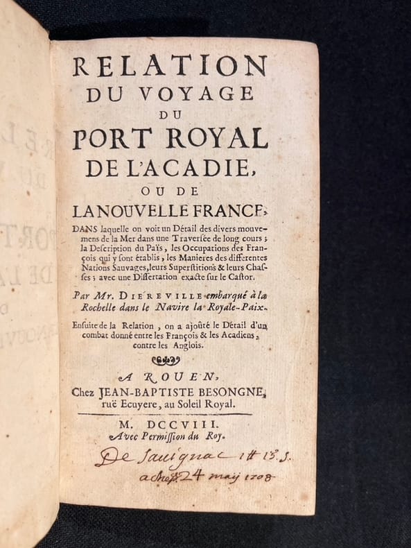
170820836A Rouen, chez Jean-Baptiste Besongne, 1708. In-12 de [14]-236-[2]-7 pages, plein veau brun, dos à nerfs orné de filets et fleurons dorés, roulette dorées sur les coupes, tranches mouchetés rouge.
elala6098<p>8vo. pp. 6 p.l. 76index 2errata li 1 372 vi 26 A-I K-Y. with half-title. original cloth-backed bds. covers soiled & worn but binding solid spine label chipped scattered light foxing. <strong>First Edition </strong>of this famous report an eloquent and forceful indictment of the Family Compact Government inspired and largely written by William Lyon Mackenzie. The grievances of the Reformers are listed in detail: concern regarding the excessive power of the executive branch in Upper Canada and the campaigning of government officials for Tory politicians during elections criticism of companies like the Welland Canal Company that mismanaged funds given to them by the government and the salaries of officials who received patronage appointments. Demands are made for an elective legislative council and responsible government. A landmark document in the political history of Upper Canada. Fleming 892. Gagnon I 2196. Lande 859. Sabin 10577. TPL 1929. Watters p. 885.</p> Toronto: M.Reynolds, Printer to the Hon. the House of Assembly, 1835. hardcover
26932(Paris), Chez Desenne, (1793-1794). 7 numbers bound in 1 volume. 1-64, (57)-72, 65-172 pp. (actualy therefore 188 pages). 8vo. 19th-century polished calf, spine with raised bands, discoloured Hatin 147; Martin & Walter, Journaux, 1402; Tourneux, ii, 10916. All published, original edition. The most eloquent journal of the Revolution. The pp. 165-172 contain the 'Copie de la lettre écrite par Camille Desmoulins à sa femme. Datée de la prison du Luxembourg' which letter ends with the moving words 'Je vais mourir!'C'est l'oeuvre le plus éloguente qu'ait produit la Révolution, et à coup sûr, avant et depuis, le journalisme n'a rien donné qui puisse lui être comparé' (Hatin).Under attack by the very radical Hébertists for poor attendance at the Convention and for socializing with the wealthy, Desmoulins published the journal as his defense. Perhaps the Terror also offended him because after blasting his assailants, he printed subtle but telling indictments of the Terror and called for clemency. It has also been suggested by many historians that Desmoulins acted to support Danton and his associates who were at the same time attacking the Hébertists and trying to limit the Terror. Thompson, in his two volume study on Robespierre even states that the aim of the journal was not to moderate the gouvernment, but to overthrow it. Whatever the truth may be, the Committee of Public Safety decided to eliminate its political opponents, which included Desmoulins, He was executed on 13 April 1794.
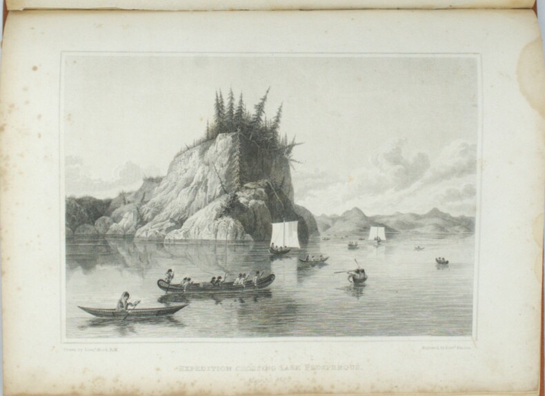
1823PHO-1666London, John Murray, 1823 et 1828, 2 volumes In-4, relié pleine toile orange, dos lisse avec pièce d’auteur et titre, date en pied, xvi-768pp. et xxvi-320pp.cvii-1f., tome 1, tâche sur les 5 premiers feuillets, petites rousseurs, mouillure angulaire sur les planches au tome 2, petits frottements à la reliure. Édition originale, illustrée de 30 planches dont 11 en couleurs pour le tome et de 31 planches au tome 2, les cartes manquent, Cachet Émile Petitot, Ex-libris manuscrit, Ex-libris Jean-Pierre Legrand-Deloron. Avec une mention signée : "membre de l'Expédition arctique T.A. 23 , 1972-1973" .