[Florida] [Georgia] Bartram, WilliamBiblio.com
1 698 résultats
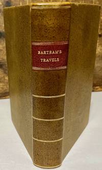
179330176Dublin: For J. Moore W. Jones R. McAllister and J. Rice 1793. Later printing. Leather bound. Very good. Octavo. xxiv 520 pages 11 page index directions to the binder. Frontispiece engraving of Mico Chlucco. Illustrated with 7 plates one folding and one folding map. Later speckled calf leather binding with red leather title label on spine. Newer front and rear end sheets added. Newer head bands top and bottom of text block. Light foxing to frontispiece engraving and title page. Light scattered occasional foxing to the contents. This edition follows the Philadelphia 1791 first edition and the first English edition of 1792. Bartram's classic account of southern natural history native Americans and exploration in the southeastern states during the American Revolution period. <br /> <br /> Howes B 223; Field 94; Sabin 3870; Clark I 197; De Renne Vol. 1 p.257; See Field 96. For J. Moore, W. Jones, R. McAllister, and J. Rice unknown
192140685Washington D.C.: Published by the United States Coast and Geodetic Survey 1921. Nautical chart printed on heavy paper stock. Colored. A rare coastal survey of Florida from Fernandina to Jacksonville including Amelia Island Atlantic Beach Neptune Beach and the St. Johns River.<br/> <br/> Established by President Thomas Jefferson in 1807 as the Survey of the Coast the U.S. Coast and Geodetic Survey was the United States' first civilian scientific agency. This agency has followed its mission to survey the U.S. coastline create nautical charts of the coast and help increase maritime safety since its founding and has often played fascinating roles in significant chapters of U.S. history. It served in all theaters of the Civil War in the service of the Union Army and Navy pioneered acoustic exploration in the wake of the sinking of the Titanic and during WWI it worked to detect enemy submarines. In addition this agency worked to survey and produce detailed maps and renderings of the U.S. coast. These nautical survey maps commonly referred to as "T-sheets" provide fascinating insights into the history of the United States coastline which has and will continue to shift. These maps are the most important data source for understanding the physical and ecological characteristics of the U.S. shoreline. The present map is a highly detailed and accurate sea chart of the Florida coast from Fernandina to Jacksonville and is an important historical view of the state. Published by the United States Coast and Geodetic Survey unknown
192140696Washington D.C.: Published by the United States Coast and Geodetic Survey 1921. Large folding nautical chart printed on heavy paper stock. Colored. A rare coastal survey of Florida from Fernandina to Jacksonville including Amelia Island Atlantic Beach Neptune Beach and the St. Johns River.<br/> <br/> Established by President Thomas Jefferson in 1807 as the Survey of the Coast the U.S. Coast and Geodetic Survey was the United States' first civilian scientific agency. This agency has followed its mission to survey the U.S. coastline create nautical charts of the coast and help increase maritime safety since its founding and has often played fascinating roles in significant chapters of U.S. history. It served in all theaters of the Civil War in the service of the Union Army and Navy pioneered acoustic exploration in the wake of the sinking of the Titanic and during WWI it worked to detect enemy submarines. In addition this agency worked to survey and produce detailed maps and renderings of the U.S. coast. These nautical survey maps commonly referred to as "T-sheets" provide fascinating insights into the history of the United States coastline which has and will continue to shift. These maps are the most important data source for understanding the physical and ecological characteristics of the U.S. shoreline. The present map is a highly detailed and accurate sea chart of Florida from Fernandina to Jacksonville and an important historical view of the developing state. Published by the United States Coast and Geodetic Survey unknown
192140700Washington D.C.: Published by the United States Coast and Geodetic Survey 1921. Large folding nautical chart printed on heavy paper stock. Colored. A rare coastal survey of Pensacola Bay including Perdido Key Pensacola and Pensacola Beach.<br/> <br/> Established by President Thomas Jefferson in 1807 as the Survey of the Coast the U.S. Coast and Geodetic Survey was the United States' first civilian scientific agency. This agency has followed its mission to survey the U.S. coastline create nautical charts of the coast and help increase maritime safety since its founding and has often played fascinating roles in significant chapters of U.S. history. It served in all theaters of the Civil War in the service of the Union Army and Navy pioneered acoustic exploration in the wake of the sinking of the Titanic and during WWI it worked to detect enemy submarines. In addition this agency worked to survey and produce detailed maps and renderings of the U.S. coast. These nautical survey maps commonly referred to as "T-sheets" provide fascinating insights into the history of the United States coastline which has and will continue to shift. These maps are the most important data source for understanding the physical and ecological characteristics of the U.S. shoreline. The present map is a highly detailed and accurate sea chart of Pensacola Bay and an important historical view of a developing Florida. Published by the United States Coast and Geodetic Survey unknown
192240699Washington D.C.: Published by the United States Coast and Geodetic Survey 1922. Large folding nautical chart printed on heavy paper stock. Colored. A rare coastal survey of Florida and Alabama around Pensacola Bay including Orange Beach Perdido Key Pensacola Pensacola Beach and Santa Rosa Island.<br/> <br/> Established by President Thomas Jefferson in 1807 as the Survey of the Coast the U.S. Coast and Geodetic Survey was the United States' first civilian scientific agency. This agency has followed its mission to survey the U.S. coastline create nautical charts of the coast and help increase maritime safety since its founding and has often played fascinating roles in significant chapters of U.S. history. It served in all theaters of the Civil War in the service of the Union Army and Navy pioneered acoustic exploration in the wake of the sinking of the Titanic and during WWI it worked to detect enemy submarines. In addition this agency worked to survey and produce detailed maps and renderings of the U.S. coast. These nautical survey maps commonly referred to as "T-sheets" provide fascinating insights into the history of the United States coastline which has and will continue to shift. These maps are the most important data source for understanding the physical and ecological characteristics of the U.S. shoreline. The present map is a highly detailed and accurate sea chart of the Pensacola area and an important historical view of a developing Florida. Published by the United States Coast and Geodetic Survey unknown
191640695Washington D.C.: Published by the United States Coast and Geodetic Survey 1916. Large folding nautical chart printed on heavy paper stock. Uncolored. A rare coastal survey of the Fort Myers area including the San Carlos Bay Caloosahatchee River Cape Coral Sanibel Island and Fort Myers Beach.<br/> <br/> Established by President Thomas Jefferson in 1807 as the Survey of the Coast the U.S. Coast and Geodetic Survey was the United States' first civilian scientific agency. This agency has followed its mission to survey the U.S. coastline create nautical charts of the coast and help increase maritime safety since its founding and has often played fascinating roles in significant chapters of U.S. history. It served in all theaters of the Civil War in the service of the Union Army and Navy pioneered acoustic exploration in the wake of the sinking of the Titanic and during WWI it worked to detect enemy submarines. In addition this agency worked to survey and produce detailed maps and renderings of the U.S. coast. These nautical survey maps commonly referred to as "T-sheets" provide fascinating insights into the history of the United States coastline which has and will continue to shift. These maps are the most important data source for understanding the physical and ecological characteristics of the U.S. shoreline. The present map is a highly detailed and accurate sea chart of Fort Myers area and an important historical view of a developing Florida. Published by the United States Coast and Geodetic Survey unknown
191740715Washington D.C.: Published by the United States Coast and Geodetic Survey 1917. Large folding nautical chart printed on heavy paper stock. Colored. Rare original coastal survey of the entrance to Tampa Bay including Anna Maria Island Bradenton and Fort De Soto Park.<br/> <br/> Established by President Thomas Jefferson in 1807 as the Survey of the Coast the U.S. Coast and Geodetic Survey was the United States' first civilian scientific agency. This agency has followed its mission to survey the U.S. coastline create nautical charts of the coast and help increase maritime safety since its founding and has often played fascinating roles in significant chapters of U.S. history. It served in all theaters of the Civil War in the service of the Union Army and Navy pioneered acoustic exploration in the wake of the sinking of the Titanic and during WWI it worked to detect enemy submarines. In addition this agency worked to survey and produce detailed maps and renderings of the U.S. coast. These nautical survey maps commonly referred to as "T-sheets" provide fascinating insights into the history of the United States coastline which has and will continue to shift. These maps are the most important data source for understanding the physical and ecological characteristics of the U.S. shoreline. The present map is a highly detailed and accurate sea chart of the Tampa region and an important historical view of a developing Florida. Published by the United States Coast and Geodetic Survey unknown
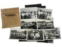
1951229201951. Jim Crow Florida Segregated public facility photograph archive from Clearwater Florida by George Fulmer 1951. Collection consists of 14 photographs including 7 black-and-white photographs and 7 associated film negatives documenting African American children in a newly opened library and schoolyard as well as a segregated swimming-pool planning meeting attended by city officials. Produced by George Fulmer Clearwater's longtime municipal photographer and WWII U.S. Navy enlisted photographer these images survive in their original studio proof envelopes from the George Fulmer Estate recovered after the 2014-2015 demolition of the Fulmer Studio which had stood beside the Clearwater Courthouse for over 65 years. The photographs measure 3.5" x 5" and the negatives are on Kodak safety film measuring 4" x 5" each. <br /> <br /> This archive captures two deeply revealing moments in the segregated civic history of mid-century Florida. The first packet labeled and dated to summer 1951 presents five photographs of Black schoolchildren reading playing circle games outdoors and participating in early library programming clear evidence of segregated educational resources but also of Black childhood joy and community-building within constrained circumstances. A white librarian or teacher is visible at the front of the classroom underscoring the racialized hierarchy embedded in Florida's school system prior to Brown v. Board of Education in 1954. The second packet likely taken only weeks apart based on Fulmer's original numbering system documents a group of white and Black men gathered around architectural plans for a segregated municipal swimming pool. The interracial nature of the planning body illuminates the complex often unequal negotiations around public development in Jim Crow Florida where recreational segregation remained legal until at least 1954-1955. These photographs represent an unusual visual record of the bureaucratic process behind segregated facilities.<br /> <br /> As part of the vast body of more than 100000 photographs preserved from Fulmer's studio much of which was claimed by the local historical society this small group represents a scarce surviving fragment of Clearwater's visual civic record with Fulmer's estate retaining a curated exhibition core and only limited dispersal of individual images. Fulmer documented weddings police activities construction projects civic events and wartime subjects but photographs relating to segregated facilities especially of Black children and community spaces are extremely limited in the archive. These images therefore constitute an important resource for researchers of Jim Crow Florida Black educational history municipal segregation and postwar Southern urban development. Photographs and negatives are crisp and clean only expressing minimal edge wear. Original Fulmer Studio proof envelopes present annotated in pencil with job numbers and subjects. Comes with two certificates of authenticity from the Fulmer estate. Overall very good condition. unknown
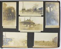
19095288Various locations mostly in Cuba and Florida: March 5 to April 1 1909. About very good. 21 leaves illustrated with 235 photographs all with typed captions. Oblong folio. Contemporary full dark brown cloth brad bound. Moderate staining and coiling to covers some edge wear. Bottom corners of all leaves chipped not costing content. Occasional minor wear to photos or captions. A well-organized and meticulously-captioned vernacular photograph album with significant content on Florida and Cuba in the first decade of the 20th century. The album is organized chronologically and features a family from Ohio traveling from home by train to Florida and thence to Cuba then returning home in the spring of 1909. The first seven and the last twenty-five photographs emanate from Ohio where the journey started Tennessee and Georgia but otherwise the album features Florida and Cuba in over 200 pictures. The scenes in Florida range from Jacksonville to Key West and other points in-between featuring the state in almost 120 photos both before and after the traveling party went to Cuba. The images capture portraits of the travelers numerous homes hotels businesses and other buildings including an ostrich farm in Jacksonville numerous scenes in Ocala including one image featuring "Mary and her old colored Mammy" various churches and other scenes in Tampa residences in Key West beach scenes at Long Key various hotels and agricultural fields in Miami and various buildings in Palm Beach Ormand and St. Augustine concluding with a front view of the "Old Slave Market" in the latter city.<br /> <br /> Most notably the album includes eighty-six photographs of Cuba the nexus point for the present trip where the party arrived on March 20. The Cuba scenes mostly feature Havana with several views of "Beautiful Residences" and other buildings plus some street views and other scenes in the city. Other interesting Havana scenes picture the railroad station "The Bone Yard -- Old destroyed Catacombs" scenes in the Malecon and more. Some of the street scenes in Havana picture local residents one of "Children on the street corner" and another showing "Children scrambling for pennies" in the middle of the street. The album also contains views of the wreck of the Maine Morro Castle the interior of Fort Cabanas and more. The travelers managed to wander outside Havana for a day when they ventured to the countryside and the town of Guines on March 23. While there the compiler took photographs of countryside outside Guines a railroad car full of sugar cane thatched houses a group photograph of the students at a "Spanish School in Guines" a "Child crying in the street" a group of locals outside a cafe captioned "Strangers in a strange land.Where we tried to get something to eat" other street scenes in the town and the local jail. The last photograph of Cuba here features a "Large Sugar Mill in Providencia." The group then returned through Florida Georgia and Tennessee where they spent a day at Lookout Mountain and Orchard Knob before their final stop in Dayton Ohio. A wonderful early-20th century travel album with significant views in Florida and Cuba. March 5 to April 1 unknown
192140729Washington D.C.: Published by the United States Coast and Geodetic Survey 1921. Large folding nautical chart printed on heavy paper stock. Colored. A rare original coastal survey of the Northern Gulf coast from Florida to Louisiana encompassing Panama City Rosemary Beach Seaside Grayton Destin Pensacola Gulf Shores Mobile Gulfport and the Mississippi Delta.<br/> <br/> Established by President Thomas Jefferson in 1807 as the Survey of the Coast the U.S. Coast and Geodetic Survey was the United States' first civilian scientific agency. This agency has followed its mission to survey the U.S. coastline create nautical charts of the coast and help increase maritime safety since its founding and has often played fascinating roles in significant chapters of U.S. history. It served in all theaters of the Civil War in the service of the Union Army and Navy pioneered acoustic exploration in the wake of the sinking of the Titanic and during WWI it worked to detect enemy submarines. In addition this agency worked to survey and produce detailed maps and renderings of the U.S. coast. These nautical survey maps commonly referred to as "T-sheets" provide fascinating insights into the history of the United States coastline which has and will continue to shift. These maps are the most important data source for understanding the physical and ecological characteristics of the U.S. shoreline. The present map is a highly detailed and accurate sea chart of the Gulf coasts of Florida Alabama Mississippi and Louisiana and an important historical view of the developing states. Published by the United States Coast and Geodetic Survey unknown
192240698Washington D.C.: Published by the United States Coast and Geodetic Survey 1922. Large folding nautical chart printed on heavy paper stock. Colored with minor wear. A rare coastal survey of the Florida coast from Fort Walton Beach to Panama City Beach including Destin Grayton Beach Seaside Alys Beach Rosemary Beach and Laguna Beach.<br/> <br/> Established by President Thomas Jefferson in 1807 as the Survey of the Coast the U.S. Coast and Geodetic Survey was the United States' first civilian scientific agency. This agency has followed its mission to survey the U.S. coastline create nautical charts of the coast and help increase maritime safety since its founding and has often played fascinating roles in significant chapters of U.S. history. It served in all theaters of the Civil War in the service of the Union Army and Navy pioneered acoustic exploration in the wake of the sinking of the Titanic and during WWI it worked to detect enemy submarines. In addition this agency worked to survey and produce detailed maps and renderings of the U.S. coast. These nautical survey maps commonly referred to as "T-sheets" provide fascinating insights into the history of the United States coastline which has and will continue to shift. These maps are the most important data source for understanding the physical and ecological characteristics of the U.S. shoreline. The present map is a highly detailed and accurate sea chart of 30A area in Florida and an important historical view of the developing state. Published by the United States Coast and Geodetic Survey unknown
191640706Washington D.C.: Published by the United States Coast and Geodetic Survey 1916. Large folding nautical chart printed on heavy paper stock. Colored. A rare coastal survey of Tampa Bay including Tampa St. Petersburg Clearwater Anna Maria Island and Bradenton.<br/> <br/> Established by President Thomas Jefferson in 1807 as the Survey of the Coast the U.S. Coast and Geodetic Survey was the United States' first civilian scientific agency. This agency has followed its mission to survey the U.S. coastline create nautical charts of the coast and help increase maritime safety since its founding and has often played fascinating roles in significant chapters of U.S. history. It served in all theaters of the Civil War in the service of the Union Army and Navy pioneered acoustic exploration in the wake of the sinking of the Titanic and during WWI it worked to detect enemy submarines. In addition this agency worked to survey and produce detailed maps and renderings of the U.S. coast. These nautical survey maps commonly referred to as "T-sheets" provide fascinating insights into the history of the United States coastline which has and will continue to shift. These maps are the most important data source for understanding the physical and ecological characteristics of the U.S. shoreline. The present map is a highly detailed and accurate sea chart of Tampa Bay and an important historical view of a developing Florida. Published by the United States Coast and Geodetic Survey unknown
191940735Washington D.C.: Published by the United States Coast and Geodetic Survey 1919. Large folding nautical chart printed on heavy paper stock. Colored. A rare original coastal survey of Florida and Georgia from Sapelo Island to Amelia Island including St. Simons Island Sea Island Brunswick Jekyll Island Cumberland Island and Fernandina Beach.<br/> <br/> Established by President Thomas Jefferson in 1807 as the Survey of the Coast the U.S. Coast and Geodetic Survey was the United States' first civilian scientific agency. This agency has followed its mission to survey the U.S. coastline create nautical charts of the coast and help increase maritime safety since its founding and has often played fascinating roles in significant chapters of U.S. history. It served in all theaters of the Civil War in the service of the Union Army and Navy pioneered acoustic exploration in the wake of the sinking of the Titanic and during WWI it worked to detect enemy submarines. In addition this agency worked to survey and produce detailed maps and renderings of the U.S. coast. These nautical survey maps commonly referred to as "T-sheets" provide fascinating insights into the history of the United States coastline which has and will continue to shift. These maps are the most important data source for understanding the physical and ecological characteristics of the U.S. shoreline. The present map is a highly detailed and accurate sea chart of the coastal border between Georgia and Florida and an important historical view of the developing states. Published by the United States Coast and Geodetic Survey unknown
191940687Washington D.C.: Published by the United States Coast and Geodetic Survey 1919. Nautical chart printed on heavy paper stock. Colored. A rare coastal survey of the Florida Georgia and South Carolina including Daytona Palm Coast St. Augustine Ponte Vedra Amelia Island Jacksonville Fernandina Jekyll Island St. Simons Sea Island Tybee Savannah Hilton Head Kiawah and Folly Beach.<br/> <br/> Established by President Thomas Jefferson in 1807 as the Survey of the Coast the U.S. Coast and Geodetic Survey was the United States' first civilian scientific agency. This agency has followed its mission to survey the U.S. coastline create nautical charts of the coast and help increase maritime safety since its founding and has often played fascinating roles in significant chapters of U.S. history. It served in all theaters of the Civil War in the service of the Union Army and Navy pioneered acoustic exploration in the wake of the sinking of the Titanic and during WWI it worked to detect enemy submarines. In addition this agency worked to survey and produce detailed maps and renderings of the U.S. coast. These nautical survey maps commonly referred to as "T-sheets" provide fascinating insights into the history of the United States coastline which has and will continue to shift. These maps are the most important data source for understanding the physical and ecological characteristics of the U.S. shoreline. The present map is a highly detailed and accurate sea chart of the coasts of Florida Georgia and Alabama and an important historical view of the developing states. Published by the United States Coast and Geodetic Survey unknown
192140692Washington D.C.: Published by the United States Coast and Geodetic Survey 1921. Nautical chart printed on heavy paper stock. Colored. A rare coastal survey of the Florida Keys including Key Largo Islamorada Long Key Marathon Key and Everglades National Park.<br/> <br/> Established by President Thomas Jefferson in 1807 as the Survey of the Coast the U.S. Coast and Geodetic Survey was the United States' first civilian scientific agency. This agency has followed its mission to survey the U.S. coastline create nautical charts of the coast and help increase maritime safety since its founding and has often played fascinating roles in significant chapters of U.S. history. It served in all theaters of the Civil War in the service of the Union Army and Navy pioneered acoustic exploration in the wake of the sinking of the Titanic and during WWI it worked to detect enemy submarines. In addition this agency worked to survey and produce detailed maps and renderings of the U.S. coast. These nautical survey maps commonly referred to as "T-sheets" provide fascinating insights into the history of the United States coastline which has and will continue to shift. These maps are the most important data source for understanding the physical and ecological characteristics of the U.S. shoreline. The present map is a highly detailed and accurate sea chart of BLANK and an important historical view of a developing Florida. Published by the United States Coast and Geodetic Survey unknown
191740708Washington D.C.: Published by the United States Coast and Geodetic Survey 1917. Large folding nautical chart printed on heavy paper stock. Colored with minor wear. A rare coastal survey of Florida from Port Canaveral to Vero Beach including Satellite Beach Melbourne and Palm Bay.<br/> <br/> Established by President Thomas Jefferson in 1807 as the Survey of the Coast the U.S. Coast and Geodetic Survey was the United States' first civilian scientific agency. This agency has followed its mission to survey the U.S. coastline create nautical charts of the coast and help increase maritime safety since its founding and has often played fascinating roles in significant chapters of U.S. history. It served in all theaters of the Civil War in the service of the Union Army and Navy pioneered acoustic exploration in the wake of the sinking of the Titanic and during WWI it worked to detect enemy submarines. In addition this agency worked to survey and produce detailed maps and renderings of the U.S. coast. These nautical survey maps commonly referred to as "T-sheets" provide fascinating insights into the history of the United States coastline which has and will continue to shift. These maps are the most important data source for understanding the physical and ecological characteristics of the U.S. shoreline. The present map is a highly detailed and accurate sea chart of the Florida coast and an important historical view of the developing state. Published by the United States Coast and Geodetic Survey unknown
191940701Washington D.C.: Published by the United States Coast and Geodetic Survey 1919. Large folding nautical chart printed on heavy paper stock. Colored. A rare coastal survey around Jacksonville including Fernandina Beach Amelia Island Jacksonville Atlantic Beach Neptune Beach Jacksonville Beach Ponte Vedra and Sawgrass.<br/> <br/> Established by President Thomas Jefferson in 1807 as the Survey of the Coast the U.S. Coast and Geodetic Survey was the United States' first civilian scientific agency. This agency has followed its mission to survey the U.S. coastline create nautical charts of the coast and help increase maritime safety since its founding and has often played fascinating roles in significant chapters of U.S. history. It served in all theaters of the Civil War in the service of the Union Army and Navy pioneered acoustic exploration in the wake of the sinking of the Titanic and during WWI it worked to detect enemy submarines. In addition this agency worked to survey and produce detailed maps and renderings of the U.S. coast. These nautical survey maps commonly referred to as "T-sheets" provide fascinating insights into the history of the United States coastline which has and will continue to shift. These maps are the most important data source for understanding the physical and ecological characteristics of the U.S. shoreline. The present map is a highly detailed and accurate sea chart of the coast around Jacksonville and an important historical view of a developing Florida. Published by the United States Coast and Geodetic Survey unknown
191940690Washington D.C.: Published by the United States Coast and Geodetic Survey 1919. Nautical chart printed on heavy paper stock. Colored with minor wear. A rare coastal survey of Fort Lauderdale Hollywood Miami and Key Biscayne.<br/> <br/> Established by President Thomas Jefferson in 1807 as the Survey of the Coast the U.S. Coast and Geodetic Survey was the United States' first civilian scientific agency. This agency has followed its mission to survey the U.S. coastline create nautical charts of the coast and help increase maritime safety since its founding and has often played fascinating roles in significant chapters of U.S. history. It served in all theaters of the Civil War in the service of the Union Army and Navy pioneered acoustic exploration in the wake of the sinking of the Titanic and during WWI it worked to detect enemy submarines. In addition this agency worked to survey and produce detailed maps and renderings of the U.S. coast. These nautical survey maps commonly referred to as "T-sheets" provide fascinating insights into the history of the United States coastline which has and will continue to shift. These maps are the most important data source for understanding the physical and ecological characteristics of the U.S. shoreline. The present map is a highly detailed and accurate sea chart of the Miami area and an important historical view of a developing Florida. Published by the United States Coast and Geodetic Survey unknown
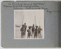
19012885Various locations in Florida 1901. About very good. 16 leaves illustrated with thirty-two original vernacular photographs all 3.5 x 3.5 inches most with manuscript captions in ink above the images. Oblong octavo. Contemporary gray paper wrappers white titles on front cover. Spine mostly split a few shallow chips to edges. Internally clean. A small but important vernacular photograph album containing rare views of the devastation wrought by the Great Fire of 1901 in Jacksonville Florida which took place on May 3 1901. The most destructive event in the history of Jacksonville the Great Fire swept through 146 city blocks destroying over 2000 buildings killing seven people and leaving almost 10000 residents without homes. It is considered the third-largest urban fire in United States history after the Great Chicago Fire and the 1906 San Francisco conflagration.<br /> <br /> The photographs in the present album were taken by an unidentified passenger aboard the Clyde Line steamer Comanche. Eight of the images capture the scene in devastated Jacksonville including a shot of the ruins of the Windsor and St. James hotels shots from atop the "Jacksonville Government Building" a group picture of the city guard "ruins of Jacksonville Court House" "An unknown ruin" a crowded scene at the Jacksonville wharf and a distant shot showing "Ruins of Jacksonville taken from Steamer Comanche May 12." All of the photographs of Jacksonville are dated in manuscript on May 12 1901 nine days after the Great Fire.<br /> <br /> In addition to the Jacksonville pictures other identified locations along the photographer's voyage include the Hillsborough River near Tampa the Tampa Court House scenes around the Tampa Bay Hotel family pictures in Florida the Comanche and its crew Fort Sumter and four views around Charleston. One particularly notable photograph shows six boys standing in shallow water holding fishing nets likely near Tampa. The image is captioned "A group of young crabbers representing three nationalities American Italian and Negro May 10 1901. unknown
191940705Washington D.C.: Published by the United States Coast and Geodetic Survey 1919. Large folding nautical chart printed on heavy paper stock. Colored. A rare coastal survey of the Florida Keys including Newfound Harbor Key Ramrod Key Summerland Key Cudjoe Key Sugarloaf Key Saddlebunch Keys and Big Coppitt Key.<br/> <br/> Established by President Thomas Jefferson in 1807 as the Survey of the Coast the U.S. Coast and Geodetic Survey was the United States' first civilian scientific agency. This agency has followed its mission to survey the U.S. coastline create nautical charts of the coast and help increase maritime safety since its founding and has often played fascinating roles in significant chapters of U.S. history. It served in all theaters of the Civil War in the service of the Union Army and Navy pioneered acoustic exploration in the wake of the sinking of the Titanic and during WWI it worked to detect enemy submarines. In addition this agency worked to survey and produce detailed maps and renderings of the U.S. coast. These nautical survey maps commonly referred to as "T-sheets" provide fascinating insights into the history of the United States coastline which has and will continue to shift. These maps are the most important data source for understanding the physical and ecological characteristics of the U.S. shoreline. The present map is a highly detailed and accurate sea chart of Florida Keys and an important historical view of a developing Florida. Published by the United States Coast and Geodetic Survey unknown
191540709Washington D.C.: Published by the United States Coast and Geodetic Survey 1915. Large folding nautical chart printed on heavy paper stock. Colored. Coastal survey map encompassing Tampa Bay up to Cape San Blas including St. Petersburg Tampa Clearwater St. George Island and Cedar Keys.<br/> <br/> Established by President Thomas Jefferson in 1807 as the Survey of the Coast the U.S. Coast and Geodetic Survey was the United States' first civilian scientific agency. This agency has followed its mission to survey the U.S. coastline create nautical charts of the coast and help increase maritime safety since its founding and has often played fascinating roles in significant chapters of U.S. history. It served in all theaters of the Civil War in the service of the Union Army and Navy pioneered acoustic exploration in the wake of the sinking of the Titanic and during WWI it worked to detect enemy submarines. In addition this agency worked to survey and produce detailed maps and renderings of the U.S. coast. These nautical survey maps commonly referred to as "T-sheets" provide fascinating insights into the history of the United States coastline which has and will continue to shift. These maps are the most important data source for understanding the physical and ecological characteristics of the U.S. shoreline. The present map is a highly detailed and accurate sea chart of the coast of Florida from Tampa Bay to Cape San Blas and is an important historical view of the developing state. Published by the United States Coast and Geodetic Survey unknown
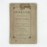
1882345842Braidentown Florida: Published by the author 1882. Second edition. Presentation copy inscribed by the author on the upper part of the front coverr. Frontispiece and illustrations. 83pp. 12mo. Original printed wrappers staining minor wear. Provenance: Thomas W. Streeter booklabel. Second edition. Presentation copy inscribed by the author on the upper part of the front coverr. Frontispiece and illustrations. 83pp. 12mo. "This is an early piece on the beginnings of settlement on the west coast of Florida below Tampa. The tract says that the railroad from Palatka on the St. John's River should be completed "within two years" and that "a narrow-gauge railroad from Tampa to the Manatee and thence to Sarasota Bay will soon follow" Streeter. The portrait is of "Madam Julia Atzeroth The Lady who raised the first coffee grown in the United States." Clark New South I:231; Streeter 1264 this copy Published by the author unknown
191740688Washington D.C.: Published by the United States Coast and Geodetic Survey 1917. Nautical chart printed on heavy paper stock. Colored. A rare coastal survey of the coast from Tampa to Venice including Sarasota Bradenton Longboat Key and Siesta Key.<br/> <br/> Established by President Thomas Jefferson in 1807 as the Survey of the Coast the U.S. Coast and Geodetic Survey was the United States' first civilian scientific agency. This agency has followed its mission to survey the U.S. coastline create nautical charts of the coast and help increase maritime safety since its founding and has often played fascinating roles in significant chapters of U.S. history. It served in all theaters of the Civil War in the service of the Union Army and Navy pioneered acoustic exploration in the wake of the sinking of the Titanic and during WWI it worked to detect enemy submarines. In addition this agency worked to survey and produce detailed maps and renderings of the U.S. coast. These nautical survey maps commonly referred to as "T-sheets" provide fascinating insights into the history of the United States coastline which has and will continue to shift. These maps are the most important data source for understanding the physical and ecological characteristics of the U.S. shoreline. The present map is a highly detailed and accurate sea chart of the coast south of Tampa and an important historical view of a developing Florida. Published by the United States Coast and Geodetic Survey unknown
191640722Washington D.C.: Published by the United States Coast and Geodetic Survey 1916. Large folding nautical chart printed on heavy paper stock. Uncolored. A rare original coastal survey of the central Florida coast around Cedar Keys.<br/> <br/> Established by President Thomas Jefferson in 1807 as the Survey of the Coast the U.S. Coast and Geodetic Survey was the United States' first civilian scientific agency. This agency has followed its mission to survey the U.S. coastline create nautical charts of the coast and help increase maritime safety since its founding and has often played fascinating roles in significant chapters of U.S. history. It served in all theaters of the Civil War in the service of the Union Army and Navy pioneered acoustic exploration in the wake of the sinking of the Titanic and during WWI it worked to detect enemy submarines. In addition this agency worked to survey and produce detailed maps and renderings of the U.S. coast. These nautical survey maps commonly referred to as "T-sheets" provide fascinating insights into the history of the United States coastline which has and will continue to shift. These maps are the most important data source for understanding the physical and ecological characteristics of the U.S. shoreline. The present map of the Florida coastline precedes the inclusion of Yankeetown; chartered in 1923 and the site of one of only two completed sections of the proposed Cross Florida Barge Canal. This map is a highly detailed and accurate sea chart of the central Florida coastal region and an important historical view of a developing Florida. Published by the United States Coast and Geodetic Survey unknown
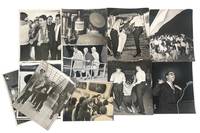
1960230921960. Cuban Refugees Caravan of Sorrow Miami Herald press photograph archive 1960 to 1966 documents Cuban exile political organizing refugee displacement and United States federal response in South Florida across the critical period between the Cuban Revolution and the Cuban Adjustment Act of 1966. The archive follows a defined sequence of events beginning with the September 1960 Caravan of Sorrow protest a demonstration organized by Cuban exile women traveling from Miami to New York to confront Fidel Castro's appearance at the United Nations and continues through the January 5 1961 closure of the Cuban consulate in Miami following the United States' severance of diplomatic relations on January 3. Subsequent photographs document the Kennedy administration's February 1961 Cuban Refugee Assistance Program centered at Miami's Freedom Tower the March 10-12 1962 Bayfront Park hunger strike in which 152 Cuban exiles demanded arms rather than humanitarian aid the October 1965 Key West arrivals during the Camarioca boatlift initiated on October 10 and the beginning of the federally organized Freedom Flights on December 1 1965. Produced by Miami Herald staff photographers Albert Coya and John Pineda both active documentarians of the Cuban exile community the archive establishes a continuous visual record of exile political life and federal refugee policy during the early Cold War.<br /> <br /> Archive of 12 Large silver gelatin press photographs Miami Herald South Florida 1960 to 1966 Each 10 x 8 inches to 9 x 7 inches with original verso annotations including dates photographer credits editorial markings crop notations and attached newspaper clippings consistent with Miami Herald press photo processing practices. Verso credits identify Albert Coya and John Pineda as staff photographers. Documented subjects include the Caravan of Sorrow bus and assembled Cuban women protesters; the January 5 1961 Cuban consulate closure; refugee intake and processing operations; the Bayfront Park hunger strike accompanied by a clipped headline reading "Exiles Seek Arms Not Aid; 152 Hunger Strikers Freed" dated March 14 1962; police arrests of demonstrators; October 1965 Key West refugee arrivals; and anti-Castro protests. Two photographs dated March 14 1962 document Cuban exiles being forcibly removed by police including one image in which a protester is carried by multiple officers and another showing an individual being thrown into a police van by armed officers providing direct visual evidence of state enforcement against exile demonstrators. One photograph depicts Costa Rican diplomat Gonzalo Facio addressing or attending a Cuban exile rally in April 1964 situating the archive within a broader hemispheric diplomatic context. Additional images show a speaker addressing a large crowd police escorting a detained protester Cuban women aboard a vessel and interior scenes of stacked materials in a processing facility including a sign reading "Se Prohiben Terminantemente." Verso notations such as "Cuban Prisoners Released 1962" "Cuban Refugees" "Anti-Castro Demonstration" and "Cuban Consulate" reflect contemporaneous editorial classification.<br /> <br /> The six-year span of the archive crosses three presidential administrations and documents multiple defining events in Cuban American history through photographs produced on assignment at the moment of occurrence. The Caravan of Sorrow images carry particular research value given later declassification of United States involvement through the Cuban Revolutionary Council placing these photographs among the few contemporaneous visual records outside government archives. The March 1962 Bayfront Park hunger strike occurring after the Bay of Pigs prisoner negotiations and before the Cuban Missile Crisis is documented with attached newspaper evidence confirming both the number of participants and their political demands providing direct insight into divisions within the exile community over United States policy. Light handling wear edge silvering and areas of foxing are present across prints; verso clippings show toning and occasional edge loss consistent with newsroom use. Overall good to very good condition. A cohesive photographer-attributed press archive documenting the development of Cuban exile political identity and United States refugee policy in South Florida during the formative early Cold War period. unknown