[African Americana]: [Louisiana]Biblio.com
248 résultats
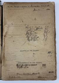
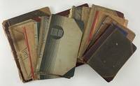
19564349Mostly Shreveport LA 1956. Good. Thirteen manuscript ledgers all quarto or folio in contemporary cloth paper or partially-leather bindings totaling approximately 650pp. of manuscript content. Condition ranges from fair to very good with a few detached covers occasional detached leaves varying levels of toning and tanning to text and other wear. Evidence of regular handling and use as expected. A highly-informative and unique manuscript record of the activities of several African-American religious and social organizations in the larger Shreveport area of Louisiana over the period of more than three decades beginning in the mid-1920s. These thirteen ledgers mainly record the minutes for organizational meetings detailing group activities and also include useful information such as member rolls monthly dues paid donations to other organizations and so forth for eleven different Black organizations in the Shreveport area some of whom are exclusively women's groups. The meeting notes record a legion of activities engaged in by the various groups often opening with the location date and time of the meetings followed by detailed reporting of activities such as organizational committee and financial reports scripture readings vocal performances the election of new members and numerous other events. The locations of the meetings sometimes include the homes of various named members. The ledgers present here are as follows in chronological order:<br /> <br /> 1 Diamond Square Lodge #170. Shreveport La. 1924-1926. 79pp. Folio. Spine perished covers detached. A highly-detailed ledger and minutes book with mostly full-page entries recording the activities of the group over a two-year period in the mid-1920s. <br /> <br /> 2 Mt. Lebanon Lodge #20. Shreveport La. 1925-1940. 132pp. Records an unusually high time frame of activities and membership information for this local Shreveport men's group with entries recorded over most of a fifteen year period with no entries for 1930-32. The ledger contains mostly meeting minutes but some of the latter section is comprised of membership dues lists. Interestingly many of the pages over the first half of the ledger are crossed out in pencil with a full-page "X" for reasons which are ultimately unclear. <br /> <br /> 3 Sunflower Choir Club #7. Shreveport and Foster La. 1931-1939. Two volumes: 15; 66pp. of manuscript entries. A co-ed organization with members referred to variously as "Brother" or "Sister." The first volume contains seven double-page manuscript tables recording the member rolls and monthly dues paid between 1931 and 1937. The second volume is a continuation of the group's records beginning with membership rolls for 1938 and 1939. This second volume also includes more than fifty pages of meeting minutes. Interestingly one page records "Disbursements" made in 1938 which included donations to two other choirs named Shiloh and Stonewall. <br /> <br /> 4 Usher Civic Association and others. Shreveport La. 1931-1939. 12pp. of manuscript. The earliest two entries record the minutes of the Usher Civic Association while some of the later entries pertain to the VFW Glee Club and other usher boards in the area. <br /> <br /> 5 Stars Chapel Church. Hosston La. Two volumes: 74; 116pp. 1939-1947. An unusually-dense and informative pair of ledgers detailing the meetings financials and other activities of this small church in the tiny town of Hosston Louisiana. Among the information here are lists of donations for church repairs and member rolls for the years 1939 to 1947. <br /> <br /> 6 Antioch Baptist Church Usher Board. Shreveport La. 1942-1944. 57pp. of manuscript text. Some portions of ledger excised. This ledger is accompanied by a delightful landscape watercolor drawing of the Antioch Baptist Church building measuring 11 x 16 inches and signed Paul L. Dutzel. This historic Black church building was constructed in 1903 and still stands precisely as it is rendered in this beautiful piece of artwork. <br /> <br /> 7 The Good Samaritan Club. Shreveport La. 1942-1943. 60pp. Some leaves detached and worn. Interestingly the early recorder of this minutes book was not a good speller often recording some version of the name of the group as "The Good Sirmaraten" or even "Good Surmearic" club. <br /> <br /> 8 Lilly Lodge #28. Shreveport La. 1951-1952. 50pp. of manuscript. A neatly-kept ledger of meeting notes and membership dues for a local Masonic group with most of the work comprised of the meeting notes with detailed membership rolls and corresponding dues amounts from the previous month listed on facing pages. Every meeting for the Lilly Lodge took place at the Union Masonic Hall in Shreveport. <br /> <br /> 9 "The Brotherhood." 1953. 9pp. Likely a partial ledger which begins on page 55 and only contains notes for a few meetings along with two double-page tables of membership rolls and dues which are only partially recorded. Still a good record of the names of this group identified only as "The Brotherhood" in the early-1950s. <br /> <br /> 10 The Elbert Net Social Club. Bossier City and Shreveport La. 1955-1956. 30pp. of manuscript. The second entry records the meeting minutes for the El Serepe Social Club while the remainder of the book relates to the Elbert Net Social Club likely renamed. In addition to a couple of entries recording meeting minutes most of the entries for this women's social organization pertain to itemized donations taken up for the birthdays of various members. For example for Gladis Hamilton's birthday in June 1955 ten different named women contributed a quarter each. <br /> <br /> 11 The El Serepe Ebanett Social Club. Bossier City La. 1955-1956. 30pp. of manuscript. Peculiar to this volume are several entries recording lists of donations collected for different purposes including meals multiple entries for a "Fish Supper" pictures corsages a "special fund" and more. Also contains some entries for meeting notes member rolls with dues information and birthday collections. <br /> <br /> African American religious social and mutual aid societies were and continue to be vital to the Black community. Traditionally these groups have provided a sense of community as well as support and assistance to one another through shared funds especially when facing systemic oppression and limited access to traditional social services including religious services access to colleagues in business government healthcare education and more. These groups were particularly important to the African-American community during the Jim Crow era when segregation largely kept Black people literally separated from the larger white society in America. Organizations such as those represented in the present collection were essential to the Black community in Louisiana before the legal end of segregation was announced through various court decisions in the mid-20th century and also helped the Black community organize during the Civil Rights Movement and beyond.<br /> <br /> Taken together the ledgers contain approximately 650 pages of manuscript entries providing a unique opportunity for not only deep study of the social activities of African Americans in the Shreveport area over the course of thirty years but also allowing for comparative analysis between the groups with particular regard to the financial information contained herein. An informative and important manuscript record of African American social life in Jim Crow Louisiana with broad research potential. unknown
196859416New Oleans La: Louisiana State Museum. As New. 1968. Paperback. FREE UPGRADE to Courier/Priority Shipping Upon Request IN STOCK AND IMMEDIATELY AVAILABLE FOR SHIPMENT - AS NEW THE TEXT BLOCK IS PRISTINE CLEAN UNMARKED AND IN EXCELLENT CONDITION - - 132 pp. With 48 ills. On 44 pls. 25 x 21 cm. -- with a bonus offer-- . Louisiana State Museum paperback
192140729Washington D.C.: Published by the United States Coast and Geodetic Survey 1921. Large folding nautical chart printed on heavy paper stock. Colored. A rare original coastal survey of the Northern Gulf coast from Florida to Louisiana encompassing Panama City Rosemary Beach Seaside Grayton Destin Pensacola Gulf Shores Mobile Gulfport and the Mississippi Delta.<br/> <br/> Established by President Thomas Jefferson in 1807 as the Survey of the Coast the U.S. Coast and Geodetic Survey was the United States' first civilian scientific agency. This agency has followed its mission to survey the U.S. coastline create nautical charts of the coast and help increase maritime safety since its founding and has often played fascinating roles in significant chapters of U.S. history. It served in all theaters of the Civil War in the service of the Union Army and Navy pioneered acoustic exploration in the wake of the sinking of the Titanic and during WWI it worked to detect enemy submarines. In addition this agency worked to survey and produce detailed maps and renderings of the U.S. coast. These nautical survey maps commonly referred to as "T-sheets" provide fascinating insights into the history of the United States coastline which has and will continue to shift. These maps are the most important data source for understanding the physical and ecological characteristics of the U.S. shoreline. The present map is a highly detailed and accurate sea chart of the Gulf coasts of Florida Alabama Mississippi and Louisiana and an important historical view of the developing states. Published by the United States Coast and Geodetic Survey unknown
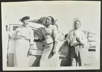
19684412Various locations in Louisiana 1968. 81 leaves illustrated with 701 photographs some in color but mostly in black-and-white. Oblong folio. Contemporary green cloth screw-bound. Moderate soiling and wear to album both covers and a few internal leaves detached. Album leaves with varying levels of chipping and wear a handful of photographs with paper remnants from being stuck to facing images on a few leaves but the great majority of images in very good or better condition. Overall good condition. A thoroughly charming and mammoth assortment of vernacular photographs documenting the activities of an African-American family and their friends in Jim Crow Louisiana. Many of the images contain dated captions printed in the borders helping to identify the time they were taken and are not arranged chronologically; the album was likely compiled some time in the mid-1960s. The wealth of images capture men women and children at home often playing with their children visiting sitting on the porch and so forth. The photographs also feature the family at church weddings family events swimming at Christmas and more. A great number of the images feature subjects posed in front of or near personal automobiles an important development in the lives of Black families in the mid-20th century. The album does not contain any captions or notations but the license plates of several automobiles in some of the images can be read clearly identifying the setting as Louisiana. Three photos document a young man and woman near a flooded portion of a neighborhood. A few of the men featured here sport military uniforms. The sheer number of images provide an excellent opportunity for further study into African-American life in Louisiana in the 1950s and '60s - a time of great transition and upheaval in the country. unknown
19334182Leesville La 1933. 135pp. Folio. Contemporary partially-printed ledger book bound in half black cloth over maroon cloth boards completed to various degrees in ink manuscript. Significant wear dust-soiling abrading and staining to binding with front joint partially split. Text block separated from spine with a few leaves detached but otherwise intact in gatherings. Varying levels of toning and dust-soiling to text but highly readable nonetheless. Fair condition. A unique and informative manuscript record book recording the activities of a local lodge of the Knights of Pythias in Louisiana during the Great Depression. Leesville Louisiana is atill a very small town located in Vernon Parish not far from the Texas border about fifty miles from Jasper Texas. The present ledger records meeting times and dates appointments and elections occasional committee reports and notes on meeting activities including communications dues paid suspensions and reinstatements of members disbursements made by the lodge and more in varying levels of detail throughout the book. As an example the September 18 1930 meeting records with original spelling retained that the committee "a pointed on claning off the graves Sir Jem Davis" and five others; the "unfinished business" portion records that "Some of the members of the Lodge was dissatisfied with their endetness to the Lodge which was tabled untill the next R.M. which will be Oct 2nd;" and new business included "Sir RJ Jefferson CC of Silver Star Lodge No. 110 of Slagle La visited Pine Tree Lodge on Sept 18 and md short talk on the good of the order" followed by a listing of four other members of the Slagle lodge who accompanied Jefferson. Naturally numerous other members of the Pine Tree Lodge and others are named throughout the activities recorded in the book providing a written record of an African-American organization struggling to maintain social standing and provide mutual aid to its members in a harrowing time in American history. unknown
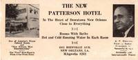
195512990New Orleans 1955. Photo-illustrated trade card 2.75 x 6.25 inches. Minor edge wear and toning horizontal crease some biopredation to bottom and right portions costing a handful of letters. Good condition. An extraordinary survival from Jim Crow Louisiana advertising the New Patterson Hotel in New Orleans owned and operated by John Robert Patterson. The hotel was the first African American-owned hotel in New Orleans and became one of the most popular during the Green Book era of African American travel. The hotel was located at two different addresses during its years of operation in which it was routinely listed in the annual publication of The Negro Traveler's Green Book. The present trade card emanates from the hotel's second location at 1815 Bienville Avenue where the hotel moved in 1954 or 1955; the hotel is listed at its first address on Rampart Street in the 1954 edition and the Bienville location by the time of the Green Book's 1955 edition.<br /> <br /> The trade card features two small photographs. At left is an image of the hotel itself with some promotional slogans beneath reading "One of America's Finest Colored Hotels and 'New Orleans Most Discriminating'" and "The 'Very' Best Place to Sleep Away from Home." The right side of the card prints a portrait of J.R. Patterson who is touted for his "Years of Business Experience in Successful Service" and "Nationally and Internationally Known." The center of the card prints information about the hotel located "In the Heart of Downtown New Orleans Close to Everything" offering "Rooms With Baths" and "Hot and Cold Running Water in Each Room" and with the address and phone number at bottom. The card is similar to the regular newspaper advertisement for the hotel printed in The Louisiana Weekly from 1956 to 1965. We could locate no other copies of this striking trade card for an important African American hotel in New Orleans founded owned and operated by a notable local businessman. unknown
191941193Washington D.C.: Published by the United States Coast and Geodetic Survey 1919. Large folding nautical chart printed on heavy paper stock. Colored. A rare original coastal survey of Gulf Coast from the Rio Grande to the Mississippi River and includes Mexico Corpus Christi Galveston and New Orleans.<br/> <br/> Established by President Thomas Jefferson in 1807 as the Survey of the Coast the U.S. Coast and Geodetic Survey was the United States' first civilian scientific agency. This agency has followed its mission to survey the U.S. coastline create nautical charts of the coast and help increase maritime safety since its founding and has often played fascinating roles in significant chapters of U.S. history. It served in all theaters of the Civil War in the service of the Union Army and Navy pioneered acoustic exploration in the wake of the sinking of the Titanic and during WWI it worked to detect enemy submarines. In addition this agency worked to survey and produce detailed maps and renderings of the U.S. coast. These nautical survey maps commonly referred to as "T-sheets" provide fascinating insights into the history of the United States coastline which has and will continue to shift. These maps are the most important data source for understanding the physical and ecological characteristics of the U.S. shoreline. The present map is notable for the inclusion of an international border at the Rio Grande River as well as for showing a miniature grid of the city of New Orleans with the Radio Station notated. It is a highly detailed and accurate sea chart of the Gulf Coasts of Mexico Texas and Louisiana and is an important historical view of the developing states along the Gulf of Mexico. Published by the United States Coast and Geodetic Survey unknown
199722760Louisiana Museum of Modern Art 1997. Hardcover. Used: Acceptable. Hardback no D/J in fair condition pages clean but cover shows some wear.The New Carlsberg Foundation's gifts to Louisiana 1988 - 1997. In English and Danish. Louisiana Museum of Modern Art hardcover
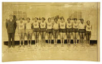
193114390Minden LA 1931. Very Good. Minden LA: 1931. Original black and white photograph 15.5x25.5cm. depicting the girls' basketball team alongside their coach Mr. Russ each player identified in ink manuscript along bottom of image. Photograph slightly curled with very small flaw at bottom of image else Very Good overall. Misidentifying manuscript label mounted to verso identifying the team in "Shreveport LA / Circa 1947 / Washington ".<br /> <br /> The label is a red herring misdating and misplacing the photograph sixteen years late and thirty miles west. The center player holds a basketball dated '31 nineteen years before Booker T. Washington High School was founded. The school almost certainly is Webster High School in Minden Louisiana thirty miles east. The building in the background and the women's slightly mismatching uniforms conform to those depicted in W.L.G. Abney's 1950s booklet "The History of Webster High School." Indeed the simple whitewashed wooden structure sitting on a brick pile foundation appears to be either the back of the dormitory or the newly-completed library the ground still unpaved dirt. <br /> <br /> The story of the founding of Webster High School less than ten years earlier in 1922 displays the dedication and financial burden of a Black community in the heart of the Jim Crow South. According to Abney's history a Colored Board of Trustees comprised of members of the community first set out to find a suitable site for a new school settling on a piece of land "owned and occupied as a home by one of Minden's colored citizens Mr. Henry Harris who was perfectly happy there and had no desire to sell." Abney glosses over the displacement of Harris but the site was secured and approved by the White Parish board "with the understanding that the colored people themselves would have to make substantial financial contribution if they were to secure this site because no money had been budgeted for the cause at that time." Indeed by 1931 the list of state-sponsored schools in Louisiana for White and Black students was sixty-eight to four. Webster was not one of those four schools. <br /> <br /> As Abney's history delineates however the money was raised by the community through the leadership and outreach of the Colored Board of Trustees and by 1931 a library had been erected and numerous sports teams active. The date is also significant as it coincides with the founding of two of the first all-Black all-women's professional basketball clubs the Philadelphia Tribune Girls and the Chicago Romas. Perhaps these pioneering teams inspired the formation of Webster High School's girls' basketball team. In any case the members listed are as follows: Coach Mr. Russ Tena Lowery Hazel Garrett Willie Stewart B. Green M. Ford Bran Watson M. Gafford E. McCorey Ella B. Gafford Lorscie Henry and Louella Ruffin. unknown
190840737Washington D.C.: Published by the United States Coast and Geodetic Survey 1908. Large folding nautical chart printed on heavy paper stock. Colored. A rare original coastal survey of the Gulf coasts of Florida Alabama Mississippi and Louisiana including the Keys Fort Myers Sarasota Tampa Panama City Destin Pensacola Gulf Shores Mobile Biloxi Gulfport New Orleans and the Mississippi Delta.<br/> <br/> Established by President Thomas Jefferson in 1807 as the Survey of the Coast the U.S. Coast and Geodetic Survey was the United States' first civilian scientific agency. This agency has followed its mission to survey the U.S. coastline create nautical charts of the coast and help increase maritime safety since its founding and has often played fascinating roles in significant chapters of U.S. history. It served in all theaters of the Civil War in the service of the Union Army and Navy pioneered acoustic exploration in the wake of the sinking of the Titanic and during WWI it worked to detect enemy submarines. In addition this agency worked to survey and produce detailed maps and renderings of the U.S. coast. These nautical survey maps commonly referred to as "T-sheets" provide fascinating insights into the history of the United States coastline which has and will continue to shift. These maps are the most important data source for understanding the physical and ecological characteristics of the U.S. shoreline. The present map is a highly detailed and accurate sea chart of the coasts Florida Alabama Mississippi and Louisiana along the Gulf of Mexico and an important historical view of the developing states. Published by the United States Coast and Geodetic Survey unknown
192041171Washington D.C.: Published by the United States Coast and Geodetic Survey 1920. Large folding nautical chart printed on heavy paper stock. Colored. A rare original coastal survey of New Orleans area and includes Lake Maurepas Lake Pontchartrain and the city of New Orleans with mentions of Audubon Park and the Cotton Exchange.<br/> <br/> Established by President Thomas Jefferson in 1807 as the Survey of the Coast the U.S. Coast and Geodetic Survey was the United States' first civilian scientific agency. This agency has followed its mission to survey the U.S. coastline create nautical charts of the coast and help increase maritime safety since its founding and has often played fascinating roles in significant chapters of U.S. history. It served in all theaters of the Civil War in the service of the Union Army and Navy pioneered acoustic exploration in the wake of the sinking of the Titanic and during WWI it worked to detect enemy submarines. In addition this agency worked to survey and produce detailed maps and renderings of the U.S. coast. These nautical survey maps commonly referred to as "T-sheets" provide fascinating insights into the history of the United States coastline which has and will continue to shift. These maps are the most important data source for understanding the physical and ecological characteristics of the U.S. shoreline. The present map of the Louisiana coastline is notable for the inclusion of New Orleans featuring Audubon Park neighborhood Carrollton and the Cotton Exchange which was demolished and rebuilt in this period. It is a highly detailed and accurate sea chart of New Orleans and neighboring lakes and an important historical view of the developing Louisiana. Published by the United States Coast and Geodetic Survey unknown
192041197Washington D.C.: Published by the United States Coast and Geodetic Survey 1920. Large folding nautical chart printed on heavy paper stock. Colored. A rare original coastal survey of Gulf Coast of Texas and Louisiana including Galveston Beaumont Sabine Lake Marsh Island Barrier Islands New Orleans Lake Pontchartrain and the Mississippi River.<br/> <br/> Established by President Thomas Jefferson in 1807 as the Survey of the Coast the U.S. Coast and Geodetic Survey was the United States' first civilian scientific agency. This agency has followed its mission to survey the U.S. coastline create nautical charts of the coast and help increase maritime safety since its founding and has often played fascinating roles in significant chapters of U.S. history. It served in all theaters of the Civil War in the service of the Union Army and Navy pioneered acoustic exploration in the wake of the sinking of the Titanic and during WWI it worked to detect enemy submarines. In addition this agency worked to survey and produce detailed maps and renderings of the U.S. coast. These nautical survey maps commonly referred to as "T-sheets" provide fascinating insights into the history of the United States coastline which has and will continue to shift. These maps are the most important data source for understanding the physical and ecological characteristics of the U.S. shoreline. The present map is starts with the city of Beaumont and the state border with Louisiana at Sabine Lake and Pass and covers the coastline until the Mississippi River past New Orleans. In the bottom left corner an enlarged map of Galveston is included. This map is a highly detailed and accurate sea chart of the Gulf Coasts of Texas and Louisiana and is an important historical view of the developing states along the Gulf of Mexico. Published by the United States Coast and Geodetic Survey unknown
19116289Crowley La: Rice Association of America; Signal Print. Co 1911. Stapled booklet 14.5 x 9 cm. 20 pages. Illustrated wrapper. Date of publication from external sources. Evident FIRST EDITION. A promotional recipe booklet encouraging the use of rice. An earlier publication titled Creole Mammy Rice Recipes was published by the Rice Association circa 1909. That work is known in a single copy at Kansas State. The dating of the two booklets is possible by comparing the tenures of various officers of the Rice Association. Creole Mammy Rice Recipes was published while Henri Gueydan was President while this booklet was issued after George Hathaway of Jennings L. ascended to the post. ~ Recipes include Rice Waffles Rice Fritters Rice Gumbo Soup Red Beans & Rice a famous Creole combination Rice Croquettes Rice Jambalaya a Daube with Rice and Rice Custard. Cooking hints recommend the use of garlic and the preference for lard over butter. “The Rice Association Crowley La. has issued a little booklet of rice recipes “Creole Mammy Rice Recipes.†In this book are given many ways of preparing rice as a hearty food instead of in desserts. Southerners use rice as Northerners use bread. Rice is served three times a day on Southern tables. Creole recipes are given for it is generally understood that the old “mammies†could turn out a dish of rice in such a delicate state of perfection that no French chef could approach them. In most ways these rice dishes could be used by vegetarians leaving out the meat additions and substituting oil or butter for the lard which is so much used in the South. The price of this booklet is two cents. Send for it and learn about rice.†The Vegetarian Magazine volume 13 page 46. The booklet weighs in on the nutritional value of rice at several points perhaps most notable in a section on the “Effect of Rice on Japanese.†Illustrated wrapper depicting a young girl nestled amongst rice branches and “on top of the worldâ€. A bit of light rubbing to wrappers; small adhesion mark to top of rear wrapper panel. Very good. Unrecorded. OCLC locates no copies; not in Brown or Uhler. Rice Association of America; Signal Print. Co unknown
19106626New Orleans; New York: The Board of Trade; Printed by H. R. Elliot & Co. Printers and Embossers 1910. Stapled booklet 10.25 x 15.25 cm. 14 unnumbered leaves; printed text decorated with red borders on rectos only. Cover title: Recipes for Cooking Rice. Author information inferred from external evidence. Printer from rear panel of wrappers. ~ Evident FIRST EDITION. A promotional publication designed “to create a greater interest†in a foodstuff that had yet to become a staple in many parts of the United States. With a dozen recipes including Gumbo Soup Jambalaya Belle Calas fritters Rice Pudding Riz au Lait. ~ The phrase “Louisiana Rice Exhibit†can be found in reference to displays in the agricultural halls of world’s fairs – the World’s Columbian Exposition Chicago 1893 for instance as well as the Louisiana Purchase Exposition St. Louis 1904 – but in the event the phrase is better understood not as an installation but as a program. The New Orleans Board of Trade had indeed exploited opportunities to educate the public by such means cf A. C. Cantley “Rice Display by Louisiana at World's Fair of 1904†The Planter and Sugar Manufacturer 32 no. 7 February 13 1904 page 121 but it would have been highly unlikely for booklets such as How to Cook Rice to have been produced specifically for them without bearing any mark of the association. Moreover Louisiana Rice Exhibits so-named were also staged at parish fairs livestock shows even horse races. Their visual aspect was meant to entrance and amuse. “The New Orleans Board of Trade made a very splendid exhibit†a trade paper reported “at the National Farm and Livestock Show with a display of all the products it handles with the centerpiece a working model of a rice mill†“Current Rice News Notes†The Rice Journal and Southern Farmer 19 no. 12 December 1916 page 33. ~ Founded in 1880 the Board itself coordinated among many other activities rice shipments from mills in Louisiana and to a smaller extent from eastern Texas and Arkansas too. In this case their printing contract with H. R. Elliot & Co. places the publication later than the Chicago Exposition as this form of name was not in use until after 1900 “The Manufacturing Stationer†Walden’s Stationer and Printer 31 Spring 1909 page 16. The date of issue proposed here rests on reports that the Board of Trade distributed booklets in or perhaps slightly before 1910 a note for example from the American Poultry World recorded that recipes from the Louisiana Rice Exhibit of New Orleans had been received 1 no. 5 March 1910 pages 354-355. ~ Interior clean and bright. Stapled in ivory wrappers with gilt illustration of rice plants overseen by a pelican in honor of the Pelican State. Near fine. OCLC locates four copies; Uhler 252; New Orleans Culinary History Group page 152; not in Bitting Brown or Cagle. [The Board of Trade; Printed by] H. R. Elliot & Co., Printers and Embossers paperback
19116877Crowley La: The Association; Printed by Signal Printing Co 1911. Small booklet 14.75 x 9 cm. 20 pages. Illustration. Printer from page 1. Date range of publication determined from internal and external evidence. Cover title: The World Food Rice: Eaten By All Peoples Adapted to All Climes. ~ Evident FIRST EDITION. An attractive collection of recipes from Cajun Country or Acadiana as it has been dubbed since the 1960s intended for distribution by mail upon request and designed to promote the consumption of rice. A memento too of a particular feat of capitalist engineering leading to the emergence of a state-of-the-art agricultural industry. Includes hints for boiling and seasoning and testimony regarding nutrition supplied by the United States Department of Agriculture. Among the twenty entries: Rice Gumbo Soup Red Beans and Rice Rice Jambalaya Daube with Rice Rice Waffles Rice Custard. ~ The so-called Rice Belt along the Gulf assumed its profile during the era when risiculture in the Carolinas and Georgia was declining above all in the decades following the Civil War. Most of the rice long cultivated on plantations of the South Atlantic had been for export to the United Kingdom and northern Europe – rice had never been a staple of the American diet – but competition there from developing Asian markets devastated the South Atlantic trade. Meanwhile a number of planters in the Gulf discerned cost advantages to shifting focus from sugar cane to rice. And in a fateful coincidence by the mid-1880s the entire region began to attract the attention of agronomists and entrepreneurs from the Midwest a significant number of them from or educated in Iowa looking to invest in the sparsely populated coastal prairie and especially in the southwestern third of Louisiana that is the twenty or so parishes inhabited chiefly by francophone Acadians. ~ But their project would need to include an expansion of the domestic market. Cooperative arrangements between corporate land speculators settlement recruiters and commercial promoters virtually invented a new industry out of whole cloth uniting the interests of farmers millers and the burgeoning railroads the overview on which this outline leans is that by Peter Coclanis “White Rice: The Midwestern Origins of the Modern Rice Industry in the United States†Rice: Global Networks and New Histories edited by Francesca Bray et al. New York: Cambridge University Press 2015 pages 291-317. A Few Rice Recipes is but one document then of a coordinated regime of marketing pamphlets newspaper notices farm-show exhibits and sightseeing tours designed to advertise the benefits of rice consumption beyond the immediate orbit of Cajun Country. Not only did initiatives of largely Midwestern origin succeed in transforming the economy of southwestern Louisiana but they also attracted government-funded support in the guise of experimental agriculture stations – evident here in quotations from reports by the Department of Agriculture. The Rice Association of America finally was one of the trade cooperatives organized in the 1890s by Seaman Knapp 1833-1911 a native of New York who had moved to Iowa in his youth to farm and to promote the interests of large-tract agriculture. Soon enough it would spawn the Rice Millers’ Association which remains one of the oldest United States agribusiness trade groups in continuous operation. ~ Among the Iowans Knapp lured to Louisiana was the president of the Association whose name heads the list of officers on page 1 of A Few Rice Recipes George Hathaway 1853-1935. He was elected in April 1910 but the span of months for the booklet’s appearance in print can be narrowed: a quotation from the September 1910 issue of the national newspaper Leslie’s Weekly occupies page 2; and the untimely death of Henry Kahn a vice-president listed on page 1 was reported in newspaper notices to have occurred on 16 March 1911. ~ In stapled wrappers with an illustration on the front panel depicting a girl nestled amongst rice culms and perched atop a globe showing the rice belt at its center. A bit of light rubbing to the wrappers; a small adhesion mark to the top of the rear panel otherwise very good. Unrecorded. OCLC locates no copies; not in Brown Cagle or Uhler. [The Association; Printed by] Signal Printing Co hardcover
192041166Washington D.C.: Published by the United States Coast and Geodetic Survey 1920. Large folding nautical chart printed on heavy paper stock. Colored. A rare original coastal survey of the Texas-Louisiana border area along the Sabine Lake and Pass into the Gulf of Mexico encompassing a portion of the Golden Triangle Area including Port Arthur and Sabine Lake.<br/> <br/> Established by President Thomas Jefferson in 1807 as the Survey of the Coast the U.S. Coast and Geodetic Survey was the United States' first civilian scientific agency. This agency has followed its mission to survey the U.S. coastline create nautical charts of the coast and help increase maritime safety since its founding and has often played fascinating roles in significant chapters of U.S. history. It served in all theaters of the Civil War in the service of the Union Army and Navy pioneered acoustic exploration in the wake of the sinking of the Titanic and during WWI it worked to detect enemy submarines. In addition this agency worked to survey and produce detailed maps and renderings of the U.S. coast. These nautical survey maps commonly referred to as "T-sheets" provide fascinating insights into the history of the United States coastline which has and will continue to shift. These maps are the most important data source for understanding the physical and ecological characteristics of the U.S. shoreline. The present map of the Texas-Louisiana coastline is notable for the inclusion of railroad founder Arthur Stillwell's Experimental Farm outside of Port Arthur on Lake Stillwell. It is a highly detailed and accurate sea chart of the southernmost border region between Texas and Louisiana and an important historical view of the developing states. Published by the United States Coast and Geodetic Survey unknown
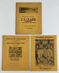
19694640Shreveport La 1969. Very good. Three programs: 48; 32; 306pp. each bound in yellow wrappers stapled. Mostly minor wear some dust-soiling a few stray ink marks one ownership signature. Overall a nice group. A trio of souvenir programs memorializing various events at Shreveport's J.S. Clark Junior High School beginning in the Jim Crow years and ending at the close of the 1960s. The earliest program was issued at the dedication ceremony for the new school in 1959. It features the speakers for the day including J.S. Clark himself group photographs of the faculty and various staff departments a list of patrons and more. The preponderance of the work is comprised of advertisements for local businesses and congratulatory messages from community members. Laid into this program is a printed letter from the day of the dedication with further information about the school. The second and third programs present here were issued to celebrate the school's annual homecoming both in October in 1967 and 1969 respectively. Each program is illustrated on the front cover with a photograph of football players. Each program contains information and sometimes images of the school its faculty the football team the Homecoming court and more with team rosters. As with the earlier dedication ceremony program these works contain numerous advertisements and well wishes from the larger community. The abundance of advertisements within these three programs provides a valuable source for studying the population of commercial and private supporters of the Black community in midcentury Shreveport. Also the programs are important as representations of the slow process of school desegregation in Louisiana specifically Shreveport. The school system in Shreveport did not fully integrate until after the Alexander v. Holmes County case in 1969 in which integration was ordered by the Supreme Court immediately no longer with "all deliberate speed. unknown
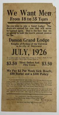
19265509Shreveport: The Service Print Shop July 1926. Good. Broadside 12 x 6 inches. Old folds small chip to upper corner noticeable soiling and staining. An unrecorded broadside advertising a membership drive for the Damon Grand Lodge of the Knights of Pythias of the Universe in Shreveport Louisiana in the midst of the Roaring Twenties. The text asks "Do you want to join a Good Lodge" before asserting that this present membership drive is a unique opportunity: "The doors are opened for you that will never be opened again." The text then relays the price for membership $3.50 and then fifty cents per month and details some of the potential benefits of joining the Knights: "We Pay $3 Per Week Sick Benefit $50 Burial and a $300 Policy." The broadside is signed in type at the bottom by B.L. McElroy Grand Chancellor of the Damon Grand Lodge. Interestingly the Damon Lodge was located 10511/2 Texas Avenue in Shreveport; the present broadside was printed by the Service Print Shop on the same street at 1009 Texas Avenue. As such the print shop was most likely a Black-owned-and-operated enterprise. Another interesting note -- near the bottom several individuals are named as contacts for prospective new members mainly pastors and doctors; most of these men also reside or work on Texas Avenue. A decidedly ephemeral and hyper-local advertisement for a Shreveport lodge of the Knights of Pythias with no copies in OCLC or anywhere we could think to check. The Service Print Shop, July unknown
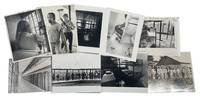
1930209001930. Prison & Incarceration Angola Prison Documentary Press Photograph Archive Depicting Inmate Living Conditions and Institutional Control at Louisiana State Penitentiary 1930-1976Former plantation Angola prison press photographs documenting Louisiana State Penitentiary the former Angola plantation turned state prison one of the most historically significant and controversial carceral institutions in the United States. Established on the grounds of a former slave plantation along the Mississippi River Angola developed into the largest maximum-security prison in the United States and became widely known during the twentieth century for forced agricultural labor racial segregation and persistent investigations into prison conditions. Photographs in this archive record inmate life security practices and the physical structure of the prison during the mid-twentieth century including images produced during the period when prison reform and incarceration policy became subjects of national debate.<br /> <br /> Archive of nine silver gelatin press photographs dating from 1930-1976 documenting the Angola prison complex and its inmates. Most photographs measure approximately 6 x 9 inches to 8 x 10 inches. Images include views of cell interiors with bunk beds and barred doors prisoners standing or moving through institutional corridors and groups of inmates assembled outdoors within the prison grounds. One photograph from 1973 shows a Black inmate seated on an upper bunk reading a book inside a crowded cell. Another 1973 image shows an unnamed Black prisoner wearing a bandana while looking outward through barred windows. A 1975 press photograph depicts a guard scanning Black inmate Kenny Johnston with a metal detector following a federal court order requiring the prison to adopt new security procedures. A 1976 image shows Black and white prisoners walking along a railway path within the prison yard dressed in everyday work clothing. The earliest photograph dated 1930 shows a group of white businessmen standing outside a wooden structure near a large stack of boxes reportedly constructed by prison labor. Several photographs retain original press captions or news articles attached verso including commentary on prison reform calling for a shift away from large centralized maximum-security institutions toward smaller community-based correctional facilities.<br /> <br /> Louisiana State Penitentiary at Angola emerged during the twentieth century as one of the most widely studied American prisons because of its origins as a former plantation and its long association with forced agricultural labor performed by incarcerated men. Convicts were historically housed in buildings originally constructed for enslaved people and compelled to work the surrounding fields. Public scrutiny intensified during the twentieth century as journalists courts and reform advocates documented violence racial inequality and inadequate living conditions inside the prison. By the 1970s the period represented most strongly in this archive the American criminal justice system faced growing calls for reform as federal courts intervened in prison administration and journalists published investigations into inmate treatment and overcrowding. Minor editorial markings and light edge wear consistent with press handling; overall condition very good. A cohesive documentary archive illustrating the lived environment of incarceration at one of the most historically consequential prisons in the United States. unknown
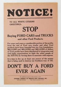
19606351New Orleans 1960. Near fine. Broadside 9 x 6 inches. Minor toning. Broadside urging the white citizens of New Orleans to stop buying Ford cars claiming Ford profits "have been distributed to integration and civil rights organizations" to the detriment of white folks "by forcing them to associate with negroes." The broadside declaims "It is time to dry up at least one source of the money that is being used to destroy our Southern way of life. Don't ever buy a Ford again." The Citizens' Council of Greater New Orleans lobbied for boycotts on several companies that they felt were encouraging Southern society into integration. unknown
192041175Washington D.C.: Published by the United States Coast and Geodetic Survey 1920. Large folding nautical chart printed on heavy paper stock. Colored. A rare original coastal survey of the end of the Mississippi River as it splits into passes of the Bird's Foot Delta into the Gulf of Mexico.<br/> <br/> Established by President Thomas Jefferson in 1807 as the Survey of the Coast the U.S. Coast and Geodetic Survey was the United States' first civilian scientific agency. This agency has followed its mission to survey the U.S. coastline create nautical charts of the coast and help increase maritime safety since its founding and has often played fascinating roles in significant chapters of U.S. history. It served in all theaters of the Civil War in the service of the Union Army and Navy pioneered acoustic exploration in the wake of the sinking of the Titanic and during WWI it worked to detect enemy submarines. In addition this agency worked to survey and produce detailed maps and renderings of the U.S. coast. These nautical survey maps commonly referred to as "T-sheets" provide fascinating insights into the history of the United States coastline which has and will continue to shift. These maps are the most important data source for understanding the physical and ecological characteristics of the U.S. shoreline. The present map of the Louisiana coastline is notable for the inclusion of the Bird's Foot Delta the mouth of the Mississipi River as it splits into smaller passes. This map is fascinating because this is the youngest lobe of the Mississippi Delta and has seen notable changes in the past 100 years. This map is a highly detailed and accurate sea chart of the Mississippi River and an important historical view of the developing Louisiana. Published by the United States Coast and Geodetic Survey unknown
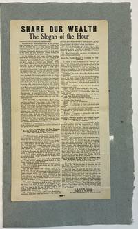
193640262Baton Rouge 1936. Folio broadside 9-3/8" x 17-1/8." Printed in two columns union bug at the bottom margin several type sizes and styles. Mounted at the upper blank verso on pale blue paper. Fine.<br /> <br /> O.K. Allen became Louisiana's governor in 1932 when Huey Long resigned the office to become a U.S. Senator. "Allen was considered a political stooge for former governor Long. His brother Earl Long once joked that a leaf blew into Allen's office one day and that he signed it thinking it was legislation from Long" Wikipedia. Gerald L.K. Smith "began his career as a leader of the populist Share the Wealth movement during the Great Depression. . . He was a preeminent antisemite and a white supremacist" Wikipedia.<br /> This broadside supports Allen's campaign to win the Democratic nomination for U.S. Senate. Huey Long's 1936 assassination had rendered the seat vacant. The broadside announces the unbreakable partnership "between the Louisiana Democratic Association of which O.K. Allen is the Head and the Share Our Wealth Society of which Gerald L.K. Smith is the Head." They have vowed to carry on the work of "our late beloved Senator Long." Allen died a week before the election.<br /> Not located on OCLC as of July 2024. unknown
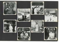
196328031New Orleans 1963. Very Good -. New Orleans: ca. 1960-1965. Large oblong quarto 27x41cm.; brown gilt-tooled leatherette bound with leather strap; 47ll. to which are mounted 311 photographic snapshots nearly all black and white and measuring 8.5x8.5cm. Album a bit scuffed at extremities joints significantly cracked from use and poor quality of leatherette leaves a bit thumbed along fore-edge margins a number of photographs apparently removed though otherwise Good to Very Good contents that remain mostly in fine condition.<br /> <br /> Extensive though sadly uncaptioned personal photo album of a young white woman in New Orleans in the early to mid-1960s documenting her social family and work life date based on shots time-stamped 1963 and 1964. What we have gathered from the contents the compiler worked at least briefly as a server at a diner whose staff was mixed-race though still separated by position: the servers all appear to be white while the grill cooks and kitchen staff are Black. <br /> <br /> Of special note are the compiler's frequent trips to the Pontchartrain Beach amusement park in New Orleans a popular destination in the 1960s though the park was sold and its rides disbursed in the 1980s due to declining attendance. This album however beautifully captures its heyday including shots of the rides carnival games swimming pool tiki bar and a perennial favorite an oversized head inside of which our compiler loved to pose. <br /> <br /> The compiler as well as being a dog-lover was evidently a serious party-goer and additional snapshot vignettes capture various couples making out at a New Year's party or dressed up for Halloween. <br /> <br /> An excellent record of white New Orleans working class life marking the advent of the Swinging Sixties. unknown
192041177Washington D.C.: Published by the United States Coast and Geodetic Survey 1920. Large folding nautical chart printed on heavy paper stock. Colored. A rare original coastal survey of Mississippi River area around the city of New Orleans.<br/> <br/> Established by President Thomas Jefferson in 1807 as the Survey of the Coast the U.S. Coast and Geodetic Survey was the United States' first civilian scientific agency. This agency has followed its mission to survey the U.S. coastline create nautical charts of the coast and help increase maritime safety since its founding and has often played fascinating roles in significant chapters of U.S. history. It served in all theaters of the Civil War in the service of the Union Army and Navy pioneered acoustic exploration in the wake of the sinking of the Titanic and during WWI it worked to detect enemy submarines. In addition this agency worked to survey and produce detailed maps and renderings of the U.S. coast. These nautical survey maps commonly referred to as "T-sheets" provide fascinating insights into the history of the United States coastline which has and will continue to shift. These maps are the most important data source for understanding the physical and ecological characteristics of the U.S. shoreline. The present map of the Louisiana coastline is notable for the inclusion of the city of New Orleans including mention of City Park and Carrollton. The map tracks the Mississippi southward to Grand Prairie. The map is a highly detailed and accurate sea chart of the New Orleans area along the Mississippi and an important historical view of developing Louisiana. Published by the United States Coast and Geodetic Survey unknown
192041170Washington D.C.: Published by the United States Coast and Geodetic Survey 1920. Large folding nautical chart printed on heavy paper stock. Colored. A rare original coastal survey of the southern Louisiana coast and includes Pecan Island Vermilion Bay and Marsh Island.<br/> <br/> Established by President Thomas Jefferson in 1807 as the Survey of the Coast the U.S. Coast and Geodetic Survey was the United States' first civilian scientific agency. This agency has followed its mission to survey the U.S. coastline create nautical charts of the coast and help increase maritime safety since its founding and has often played fascinating roles in significant chapters of U.S. history. It served in all theaters of the Civil War in the service of the Union Army and Navy pioneered acoustic exploration in the wake of the sinking of the Titanic and during WWI it worked to detect enemy submarines. In addition this agency worked to survey and produce detailed maps and renderings of the U.S. coast. These nautical survey maps commonly referred to as "T-sheets" provide fascinating insights into the history of the United States coastline which has and will continue to shift. These maps are the most important data source for understanding the physical and ecological characteristics of the U.S. shoreline. The present map of the Louisiana coastline is notable for the inclusion of Marsh Island which was deeded to the state in 1920 the year this map was produced. It is a highly detailed and accurate sea chart of the Vermilion Bay and an important historical view of the developing Louisiana. Published by the United States Coast and Geodetic Survey unknown