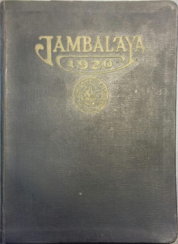
JAMBALAYA 1920 Nombreuses illustrations de Stephen d'Amico.Livre Rare Book
247 résultats
192027383Couverture rigide. Reliure de l'éditeur. 306 pages + publicités. 20 x 27 cm.
1998016314Hollywood California U.S.A.: Seven Arts Pr 1998. Book. Fine. Oblong Paperback. First Edition. A Fine copy of this oversized exhibition catalog. Seven Arts Pr Paperback
192041176Washington D.C.: Published by the United States Coast and Geodetic Survey 1920. Large folding nautical chart printed on heavy paper stock. Colored. A rare original coastal survey of southern Louisiana coast and includes Pecan Island Lower Mud Lake the Rockefeller Wildlife Refuge and the Mementau River.<br/> <br/> Established by President Thomas Jefferson in 1807 as the Survey of the Coast the U.S. Coast and Geodetic Survey was the United States' first civilian scientific agency. This agency has followed its mission to survey the U.S. coastline create nautical charts of the coast and help increase maritime safety since its founding and has often played fascinating roles in significant chapters of U.S. history. It served in all theaters of the Civil War in the service of the Union Army and Navy pioneered acoustic exploration in the wake of the sinking of the Titanic and during WWI it worked to detect enemy submarines. In addition this agency worked to survey and produce detailed maps and renderings of the U.S. coast. These nautical survey maps commonly referred to as "T-sheets" provide fascinating insights into the history of the United States coastline which has and will continue to shift. These maps are the most important data source for understanding the physical and ecological characteristics of the U.S. shoreline. The present map is a highly detailed and accurate sea chart of the southern Louisiana coast from Pecan Island to the Mementau River and an important historical view of the developing Louisiana. Published by the United States Coast and Geodetic Survey unknown
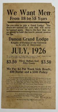
19265509Shreveport: The Service Print Shop July 1926. Good. Broadside 12 x 6 inches. Old folds small chip to upper corner noticeable soiling and staining. An unrecorded broadside advertising a membership drive for the Damon Grand Lodge of the Knights of Pythias of the Universe in Shreveport Louisiana in the midst of the Roaring Twenties. The text asks "Do you want to join a Good Lodge" before asserting that this present membership drive is a unique opportunity: "The doors are opened for you that will never be opened again." The text then relays the price for membership $3.50 and then fifty cents per month and details some of the potential benefits of joining the Knights: "We Pay $3 Per Week Sick Benefit $50 Burial and a $300 Policy." The broadside is signed in type at the bottom by B.L. McElroy Grand Chancellor of the Damon Grand Lodge. Interestingly the Damon Lodge was located 10511/2 Texas Avenue in Shreveport; the present broadside was printed by the Service Print Shop on the same street at 1009 Texas Avenue. As such the print shop was most likely a Black-owned-and-operated enterprise. Another interesting note -- near the bottom several individuals are named as contacts for prospective new members mainly pastors and doctors; most of these men also reside or work on Texas Avenue. A decidedly ephemeral and hyper-local advertisement for a Shreveport lodge of the Knights of Pythias with no copies in OCLC or anywhere we could think to check. The Service Print Shop, July unknown
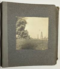
19033176Various locations in Louisiana 1903. About very good. Twelve leaves illustrated with twenty silver gelatin photographs. Contemporary gray cloth photograph album string-tied front cover stamped in gilt "The Kodak Book." Noticeable soiling and rubbing to boards edges worn. Two photographs detached mild wear to a few pictures but overall nice condition. A charming collection of vernacular images of southern Louisiana in the first few years of the 20th century taken by local resident May Hill Wilkinson. Wilkinson has signed the inside front cover in pencil "Mrs. C A Wilkinson May Hill Lake Charles and Jennings." Additionally manuscript notes on the inside front cover a couple of slips inside the album and on the verso of one of the loose photographs also indicate Wilkinson's authorship of the pictures per her daughter Lyllis who indicates the pictures were taken before she was born in Jennings in 1904. Wilkinson's photographs mostly depict scenes on the waters of Lake Charles and Lake Arthur but also include a handful of scenes in the wooded areas around Jennings.<br /> <br /> A particularly striking photograph captures an oil field fire in Evangeline Louisiana according to a later note from Lyllis opposite the photo; Evangeline is only six miles from Jennings and was the site of the first oil strike in Louisiana in September 1901. Wilkinson's photograph captures a billowing cloud of smoke at left with men and oil derricks visible to the right. This is likely one of the earliest vernacular photographs of the Evangeline Oil Field which would bring untold riches to the people of Jennings. A nice mixture of images from a time and place rarely seen in vernacular photographs. unknown
192041170Washington D.C.: Published by the United States Coast and Geodetic Survey 1920. Large folding nautical chart printed on heavy paper stock. Colored. A rare original coastal survey of the southern Louisiana coast and includes Pecan Island Vermilion Bay and Marsh Island.<br/> <br/> Established by President Thomas Jefferson in 1807 as the Survey of the Coast the U.S. Coast and Geodetic Survey was the United States' first civilian scientific agency. This agency has followed its mission to survey the U.S. coastline create nautical charts of the coast and help increase maritime safety since its founding and has often played fascinating roles in significant chapters of U.S. history. It served in all theaters of the Civil War in the service of the Union Army and Navy pioneered acoustic exploration in the wake of the sinking of the Titanic and during WWI it worked to detect enemy submarines. In addition this agency worked to survey and produce detailed maps and renderings of the U.S. coast. These nautical survey maps commonly referred to as "T-sheets" provide fascinating insights into the history of the United States coastline which has and will continue to shift. These maps are the most important data source for understanding the physical and ecological characteristics of the U.S. shoreline. The present map of the Louisiana coastline is notable for the inclusion of Marsh Island which was deeded to the state in 1920 the year this map was produced. It is a highly detailed and accurate sea chart of the Vermilion Bay and an important historical view of the developing Louisiana. Published by the United States Coast and Geodetic Survey unknown
192141179Washington D.C.: Published by the United States Coast and Geodetic Survey 1921. Large folding nautical chart printed on heavy paper stock. Uncolored. A rare original coastal survey of Vermillion Parish including Vermilion Bay Marsh Island Pecan Island White Lake Cote Blanche Bay and Trinity Shoal.<br/> <br/> Established by President Thomas Jefferson in 1807 as the Survey of the Coast the U.S. Coast and Geodetic Survey was the United States' first civilian scientific agency. This agency has followed its mission to survey the U.S. coastline create nautical charts of the coast and help increase maritime safety since its founding and has often played fascinating roles in significant chapters of U.S. history. It served in all theaters of the Civil War in the service of the Union Army and Navy pioneered acoustic exploration in the wake of the sinking of the Titanic and during WWI it worked to detect enemy submarines. In addition this agency worked to survey and produce detailed maps and renderings of the U.S. coast. These nautical survey maps commonly referred to as "T-sheets" provide fascinating insights into the history of the United States coastline which has and will continue to shift. These maps are the most important data source for understanding the physical and ecological characteristics of the U.S. shoreline. The present map of the Louisiana coastline is notable for the inclusion of Marsh Island which was deeded to the state in 1920 the year this map was produced. It is a highly detailed and accurate sea chart of the Vermilion Parish and an important historical view of the developing Louisiana. Published by the United States Coast and Geodetic Survey unknown
1949ZB447296Baton Rouge: ca. 1949. oblong quarto 32 pp. illustrated throughout; minor library markings later plain paper wrappers over original printed paper wrappers good. - If you are reading this this item is actually physically in our stock and ready for shipment once ordered. We are not bookjackers. Buyer is responsible for any additional duties taxes or fees required by recipient's country. Baton Rouge: unknown
1955011818New Orleans: National Association of the Colonial Dames of America in the State of Louisiana 1955. 4th Printing. Soft cover. Very Good. Local New Orleans cookbook published on the occasion of Mardi Gras this apparently the first version that became an annual publication. Stated fourth printing 1955 after the first 1952 on the copyright page. Spiral bound illustrated covers of polished stock the front cover a bit soiled the rear cover with an abraded patch. Internals as new. 196 pages. Illustrations credited to Marjorie Clark Ferguson. National Association of the Colonial Dames of America in the State of Louisiana unknown books
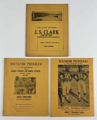
19694640Shreveport La 1969. Very good. Three programs: 48; 32; 306pp. each bound in yellow wrappers stapled. Mostly minor wear some dust-soiling a few stray ink marks one ownership signature. Overall a nice group. A trio of souvenir programs memorializing various events at Shreveport's J.S. Clark Junior High School beginning in the Jim Crow years and ending at the close of the 1960s. The earliest program was issued at the dedication ceremony for the new school in 1959. It features the speakers for the day including J.S. Clark himself group photographs of the faculty and various staff departments a list of patrons and more. The preponderance of the work is comprised of advertisements for local businesses and congratulatory messages from community members. Laid into this program is a printed letter from the day of the dedication with further information about the school. The second and third programs present here were issued to celebrate the school's annual homecoming both in October in 1967 and 1969 respectively. Each program is illustrated on the front cover with a photograph of football players. Each program contains information and sometimes images of the school its faculty the football team the Homecoming court and more with team rosters. As with the earlier dedication ceremony program these works contain numerous advertisements and well wishes from the larger community. The abundance of advertisements within these three programs provides a valuable source for studying the population of commercial and private supporters of the Black community in midcentury Shreveport. Also the programs are important as representations of the slow process of school desegregation in Louisiana specifically Shreveport. The school system in Shreveport did not fully integrate until after the Alexander v. Holmes County case in 1969 in which integration was ordered by the Supreme Court immediately no longer with "all deliberate speed. unknown
1999LFA-126714926Un ouvrage de 178 pages, format 160 x 240 mm, illustré, broché couverture couleurs, publié en 1999, Cheminements, bon état
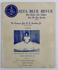
19754636Shreveport La 1975. Very good. 36pp. Original cream pictorial wrappers printed in blue stapled. Text printed in blue. Minor wear and some soiling to wrappers. A few blue pen marks to wrappers and a few text pages. An unrecorded program for a bass baritone performance by Reverend John D.V. Hamilton Jr. hosted by the Shreveport chapter of the Zeta Phi Beta Sorority. The program includes the schedule of events for the night of the performance which took place at the Shreveport Convention Theatre on September 21 1975 but also includes much more information on the African American community of the area. The program is profusely illustrated with photographs of sorority members Hamilton himself local Black political candidates and more and includes lists of the Blue Revue Committee the chapter members a biographical sketch of Hamilton and much more. In addition the work contains a great many well wishes from various parties and numerous advertisements for local businesses serving the Black community in Shreveport such as the Shreveport Sun newspaper the Benevolent Life Insurance Company Armanda's Beauty Salon J.S. Williams & Son Funeral Home and many others. Hamilton's musical performances included pieces by Handel Tchaikovsky Rodgers and Hammerstein Gershwin and one of his own compositions as part of a section of songs called "God in the Black Experience." We could locate no other copies of this program in OCLC or elsewhere. unknown
190460900St. Louis MO: N.D. Thompson Publishing Co. 1904. Oblong folio. 13.75 x 11.25 in. 2 302 2 pp. Colour frontisp. over 300 photo plates. Burgundy-coloured cloth over beveled boards black lettering on front cover ruled embossed in blind on front cover minor rubbing edgewear expertly recased a few minor paper repairs gutter margin repair still VG bright copy from the library of Prof. Marvin Nathan. First “Library edition†of this photographic guidebook to the St. Louis Worlds Fair Louisiana Purchase Exposition offering a comprehensive illustrated tour to the famed event. Exterior views the Midway the Ferris Wheel interiors of all the exhibits sporting events and more. The Louisiana Purchase Exposition spread over 1200 acres and incorporated education into all aspects of the exhibitors including blacksmiths at work Native Americans living in their villages transplanted Philippine Moro natives elephant trainers lion tamers and more. Visitors to The Pike -- the mile long midway -- could scale the Tyrolean Alps visit Blarney Castle a Parisian fashion show dive under the sea or ride a burro to Cliff Dwellings. The 1904 St. Louis Fair also featured the first Airship races contest which offered a prize if the competing airships could complete the course three times at a speed of 15 m.p.h. A photo of Hippolyte Francis’s airship Ville de St. Mande depicts the airship in flight with a 100 foot long gasbag and 35 feet in diameter. Workmen had to dig a trench to get the ship out of the aerodrome and it later crashed into the concourse fence and did not fly again. N.D. Thompson Publishing Co., hardcover
190460954St. Louis MO: Alfred W. Martin 1904. One small broadside sheet on blue-tinted laid-paper watermark visible blue lettering & border fold crease at center NF copy. First edition of this exceptionally scarce promotion for Martin’s audio-visual presentation at the 1904 St. Louis World’s Fair with the lecture touching on the fundamental aims of the three great Fairs in Chicago Paris and then St. Louis followed by discussion of the architecture transportation and more. He also details the living zoo exhibit of the Philippine village as well as the pageantry of the Boer War exhibit performances and the Tyrolean Alps. Martin 1862-1932 was a Unitarian minister and author of several works on religion and also frequently wrote on comparative religions. No copies in Worldcat. Alfred W. Martin, unknown
19116289Crowley La: Rice Association of America; Signal Print. Co 1911. Stapled booklet 14.5 x 9 cm. 20 pages. Illustrated wrapper. Date of publication from external sources. Evident FIRST EDITION. A promotional recipe booklet encouraging the use of rice. An earlier publication titled Creole Mammy Rice Recipes was published by the Rice Association circa 1909. That work is known in a single copy at Kansas State. The dating of the two booklets is possible by comparing the tenures of various officers of the Rice Association. Creole Mammy Rice Recipes was published while Henri Gueydan was President while this booklet was issued after George Hathaway of Jennings L. ascended to the post. ~ Recipes include Rice Waffles Rice Fritters Rice Gumbo Soup Red Beans & Rice a famous Creole combination Rice Croquettes Rice Jambalaya a Daube with Rice and Rice Custard. Cooking hints recommend the use of garlic and the preference for lard over butter. “The Rice Association Crowley La. has issued a little booklet of rice recipes “Creole Mammy Rice Recipes.†In this book are given many ways of preparing rice as a hearty food instead of in desserts. Southerners use rice as Northerners use bread. Rice is served three times a day on Southern tables. Creole recipes are given for it is generally understood that the old “mammies†could turn out a dish of rice in such a delicate state of perfection that no French chef could approach them. In most ways these rice dishes could be used by vegetarians leaving out the meat additions and substituting oil or butter for the lard which is so much used in the South. The price of this booklet is two cents. Send for it and learn about rice.†The Vegetarian Magazine volume 13 page 46. The booklet weighs in on the nutritional value of rice at several points perhaps most notable in a section on the “Effect of Rice on Japanese.†Illustrated wrapper depicting a young girl nestled amongst rice branches and “on top of the worldâ€. A bit of light rubbing to wrappers; small adhesion mark to top of rear wrapper panel. Very good. Unrecorded. OCLC locates no copies; not in Brown or Uhler. Rice Association of America; Signal Print. Co unknown
1984Q-0916137007Louisiana State Museum 1984-01-01. Paperback. New. In shrink wrap. Looks like an interesting title! Louisiana State Museum paperback
190519444Philadelphia: Pennsylvania Commission 1905. First edition. Hardcover. Orig. red buckram with gilt seal of Pennsylvania front cover. Teg. Very Good. 364 pages. 25 x 17 cm. Description of buildings art mines agriculture and transportation; black and white illustrations and catalogue of awards. Bookplate uncut spine slightly sunned crisp clean copy. Pennsylvania Commission hardcover books
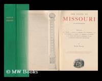
1904117164Columbia Mo. : Press Of E. W. Stephens 1904. First Edition. Hardback. Near fine copy in gilt-blocked cloth. Slightest suggestion of wear to spine band. Remains particularly well-preserved overall; tight bright clean and strong. ; 592 pages; Description: 5 p. L. 592 p. Incl. Front. Illus. ports. maps partly fold. facsims. 26 cm. Subjects: Missouri. Missouri --Description and travel --Maps. Columbia, Mo. : Press Of E. W. Stephens hardcover
199323519Lafayette Louisiana U.S.A.: Univ of Louisiana at Lafayette 1993. Hardback in near fine condition. Gift inscription on front end page. 2nd edition. 2nd Edition. Hardcover. Near Fine. Lafayette, Louisiana, U.S.A.: Univ of Louisiana at Lafayette Hardcover
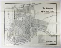
19062664New Orleans 1906. Very good. Sheet map 22 x 28 inches. Old folds. Minor soiling and wear. Scarce map of New Orleans issued by the Times Picayune. The map shows the city spread between Lake Pontchartrain to the north and the Mississippi River to the south with details of streets drainage railroads electric car lines and other points of interest. A numbered legend highlights various important locales such as the Picayune's offices City Hall different squares and parks the French Market and the railroad hubs. unknown
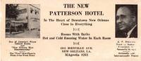
195512990New Orleans 1955. Photo-illustrated trade card 2.75 x 6.25 inches. Minor edge wear and toning horizontal crease some biopredation to bottom and right portions costing a handful of letters. Good condition. An extraordinary survival from Jim Crow Louisiana advertising the New Patterson Hotel in New Orleans owned and operated by John Robert Patterson. The hotel was the first African American-owned hotel in New Orleans and became one of the most popular during the Green Book era of African American travel. The hotel was located at two different addresses during its years of operation in which it was routinely listed in the annual publication of The Negro Traveler's Green Book. The present trade card emanates from the hotel's second location at 1815 Bienville Avenue where the hotel moved in 1954 or 1955; the hotel is listed at its first address on Rampart Street in the 1954 edition and the Bienville location by the time of the Green Book's 1955 edition.<br /> <br /> The trade card features two small photographs. At left is an image of the hotel itself with some promotional slogans beneath reading "One of America's Finest Colored Hotels and 'New Orleans Most Discriminating'" and "The 'Very' Best Place to Sleep Away from Home." The right side of the card prints a portrait of J.R. Patterson who is touted for his "Years of Business Experience in Successful Service" and "Nationally and Internationally Known." The center of the card prints information about the hotel located "In the Heart of Downtown New Orleans Close to Everything" offering "Rooms With Baths" and "Hot and Cold Running Water in Each Room" and with the address and phone number at bottom. The card is similar to the regular newspaper advertisement for the hotel printed in The Louisiana Weekly from 1956 to 1965. We could locate no other copies of this striking trade card for an important African American hotel in New Orleans founded owned and operated by a notable local businessman. unknown
192041177Washington D.C.: Published by the United States Coast and Geodetic Survey 1920. Large folding nautical chart printed on heavy paper stock. Colored. A rare original coastal survey of Mississippi River area around the city of New Orleans.<br/> <br/> Established by President Thomas Jefferson in 1807 as the Survey of the Coast the U.S. Coast and Geodetic Survey was the United States' first civilian scientific agency. This agency has followed its mission to survey the U.S. coastline create nautical charts of the coast and help increase maritime safety since its founding and has often played fascinating roles in significant chapters of U.S. history. It served in all theaters of the Civil War in the service of the Union Army and Navy pioneered acoustic exploration in the wake of the sinking of the Titanic and during WWI it worked to detect enemy submarines. In addition this agency worked to survey and produce detailed maps and renderings of the U.S. coast. These nautical survey maps commonly referred to as "T-sheets" provide fascinating insights into the history of the United States coastline which has and will continue to shift. These maps are the most important data source for understanding the physical and ecological characteristics of the U.S. shoreline. The present map of the Louisiana coastline is notable for the inclusion of the city of New Orleans including mention of City Park and Carrollton. The map tracks the Mississippi southward to Grand Prairie. The map is a highly detailed and accurate sea chart of the New Orleans area along the Mississippi and an important historical view of developing Louisiana. Published by the United States Coast and Geodetic Survey unknown
20002-4H0881924776BRAND NEW. Gift quality. Great condition No remainder mark.2-4H Timber Press, Incorporated hardcover
2000119045Gretna, Firebird Press 2000 In-8 23 x 15,5 cm. Broché, couverture illustrée, LXII-469 pp., index, table des matières. Exemplaire en bon état.
190460923St. Louis MO: Official Photographic Company Louisiana Purchase Exposition Co. Robert A. Reid 1904. 12mo. Die-cut heart-shaped sized 6 x 6.25 in. 49 leaves unnumbered. With 47 photo plates all w/ decorative borders. Colour-illustrated softcovers sewing hole at upper fore-edge punch-sewn w/ silk thread slight creasing to upper left fore-edge minor edgewear still a VG copy. First edition of this charming and inventive souvenir view book to the St. Louis Worlds Fair Louisiana Purchase Exposition offering a comprehensive illustrated tour to the famed event. The opening images reflect the contemporary fascination with the ethnological “Human Zoo†indigenous people’s exhibits on “The Pike†including photos of the Native Americans at the Indian Congress Philippine Igorrots dancing Singalese dancers geisha girls at the Japanese tea house the Chinese Pavilion and other exhibits. Also included are views of the Palaces of Mines & Liberal Arts Palace of Agriculture East Plaza with giant statues of Lewis & Clark the Louisiana Purchase Stock show featuring eleven prize steers the Ferris Wheel exhibit interiors and more. Worldcat loctes 7 copies CS Fresno History CO DLC U of DE Missouri Hist. Mus Bryn Mawr SMU. Official Photographic Company, Louisiana Purchase Exposition Co., Robert A. Reid, paperback