1 088 résultats
19116289Crowley La: Rice Association of America; Signal Print. Co 1911. Stapled booklet 14.5 x 9 cm. 20 pages. Illustrated wrapper. Date of publication from external sources. Evident FIRST EDITION. A promotional recipe booklet encouraging the use of rice. An earlier publication titled Creole Mammy Rice Recipes was published by the Rice Association circa 1909. That work is known in a single copy at Kansas State. The dating of the two booklets is possible by comparing the tenures of various officers of the Rice Association. Creole Mammy Rice Recipes was published while Henri Gueydan was President while this booklet was issued after George Hathaway of Jennings L. ascended to the post. ~ Recipes include Rice Waffles Rice Fritters Rice Gumbo Soup Red Beans & Rice a famous Creole combination Rice Croquettes Rice Jambalaya a Daube with Rice and Rice Custard. Cooking hints recommend the use of garlic and the preference for lard over butter. “The Rice Association Crowley La. has issued a little booklet of rice recipes “Creole Mammy Rice Recipes.†In this book are given many ways of preparing rice as a hearty food instead of in desserts. Southerners use rice as Northerners use bread. Rice is served three times a day on Southern tables. Creole recipes are given for it is generally understood that the old “mammies†could turn out a dish of rice in such a delicate state of perfection that no French chef could approach them. In most ways these rice dishes could be used by vegetarians leaving out the meat additions and substituting oil or butter for the lard which is so much used in the South. The price of this booklet is two cents. Send for it and learn about rice.†The Vegetarian Magazine volume 13 page 46. The booklet weighs in on the nutritional value of rice at several points perhaps most notable in a section on the “Effect of Rice on Japanese.†Illustrated wrapper depicting a young girl nestled amongst rice branches and “on top of the worldâ€. A bit of light rubbing to wrappers; small adhesion mark to top of rear wrapper panel. Very good. Unrecorded. OCLC locates no copies; not in Brown or Uhler. Rice Association of America; Signal Print. Co unknown
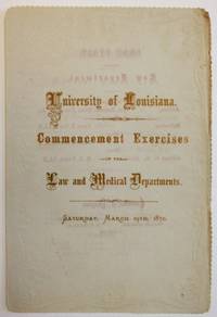
187036136New Orleans 1870. Folded decorative leaf stamped in blind. 3 1 blank pp. Title printed in gilt lettering text in beige lettering. Very Good.<br /> <br /> The University of Louisiana is the predecessor of Tulane University in New Orleans. The commencement program of each department is printed noting the salutatorian and valedictorian and committees of each department. <br /> See OCLC 320842972 1- LSU. unknown
192141179Washington D.C.: Published by the United States Coast and Geodetic Survey 1921. Large folding nautical chart printed on heavy paper stock. Uncolored. A rare original coastal survey of Vermillion Parish including Vermilion Bay Marsh Island Pecan Island White Lake Cote Blanche Bay and Trinity Shoal.<br/> <br/> Established by President Thomas Jefferson in 1807 as the Survey of the Coast the U.S. Coast and Geodetic Survey was the United States' first civilian scientific agency. This agency has followed its mission to survey the U.S. coastline create nautical charts of the coast and help increase maritime safety since its founding and has often played fascinating roles in significant chapters of U.S. history. It served in all theaters of the Civil War in the service of the Union Army and Navy pioneered acoustic exploration in the wake of the sinking of the Titanic and during WWI it worked to detect enemy submarines. In addition this agency worked to survey and produce detailed maps and renderings of the U.S. coast. These nautical survey maps commonly referred to as "T-sheets" provide fascinating insights into the history of the United States coastline which has and will continue to shift. These maps are the most important data source for understanding the physical and ecological characteristics of the U.S. shoreline. The present map of the Louisiana coastline is notable for the inclusion of Marsh Island which was deeded to the state in 1920 the year this map was produced. It is a highly detailed and accurate sea chart of the Vermilion Parish and an important historical view of the developing Louisiana. Published by the United States Coast and Geodetic Survey unknown
192041170Washington D.C.: Published by the United States Coast and Geodetic Survey 1920. Large folding nautical chart printed on heavy paper stock. Colored. A rare original coastal survey of the southern Louisiana coast and includes Pecan Island Vermilion Bay and Marsh Island.<br/> <br/> Established by President Thomas Jefferson in 1807 as the Survey of the Coast the U.S. Coast and Geodetic Survey was the United States' first civilian scientific agency. This agency has followed its mission to survey the U.S. coastline create nautical charts of the coast and help increase maritime safety since its founding and has often played fascinating roles in significant chapters of U.S. history. It served in all theaters of the Civil War in the service of the Union Army and Navy pioneered acoustic exploration in the wake of the sinking of the Titanic and during WWI it worked to detect enemy submarines. In addition this agency worked to survey and produce detailed maps and renderings of the U.S. coast. These nautical survey maps commonly referred to as "T-sheets" provide fascinating insights into the history of the United States coastline which has and will continue to shift. These maps are the most important data source for understanding the physical and ecological characteristics of the U.S. shoreline. The present map of the Louisiana coastline is notable for the inclusion of Marsh Island which was deeded to the state in 1920 the year this map was produced. It is a highly detailed and accurate sea chart of the Vermilion Bay and an important historical view of the developing Louisiana. Published by the United States Coast and Geodetic Survey unknown
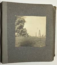
19033176Various locations in Louisiana 1903. About very good. Twelve leaves illustrated with twenty silver gelatin photographs. Contemporary gray cloth photograph album string-tied front cover stamped in gilt "The Kodak Book." Noticeable soiling and rubbing to boards edges worn. Two photographs detached mild wear to a few pictures but overall nice condition. A charming collection of vernacular images of southern Louisiana in the first few years of the 20th century taken by local resident May Hill Wilkinson. Wilkinson has signed the inside front cover in pencil "Mrs. C A Wilkinson May Hill Lake Charles and Jennings." Additionally manuscript notes on the inside front cover a couple of slips inside the album and on the verso of one of the loose photographs also indicate Wilkinson's authorship of the pictures per her daughter Lyllis who indicates the pictures were taken before she was born in Jennings in 1904. Wilkinson's photographs mostly depict scenes on the waters of Lake Charles and Lake Arthur but also include a handful of scenes in the wooded areas around Jennings.<br /> <br /> A particularly striking photograph captures an oil field fire in Evangeline Louisiana according to a later note from Lyllis opposite the photo; Evangeline is only six miles from Jennings and was the site of the first oil strike in Louisiana in September 1901. Wilkinson's photograph captures a billowing cloud of smoke at left with men and oil derricks visible to the right. This is likely one of the earliest vernacular photographs of the Evangeline Oil Field which would bring untold riches to the people of Jennings. A nice mixture of images from a time and place rarely seen in vernacular photographs. unknown
192041176Washington D.C.: Published by the United States Coast and Geodetic Survey 1920. Large folding nautical chart printed on heavy paper stock. Colored. A rare original coastal survey of southern Louisiana coast and includes Pecan Island Lower Mud Lake the Rockefeller Wildlife Refuge and the Mementau River.<br/> <br/> Established by President Thomas Jefferson in 1807 as the Survey of the Coast the U.S. Coast and Geodetic Survey was the United States' first civilian scientific agency. This agency has followed its mission to survey the U.S. coastline create nautical charts of the coast and help increase maritime safety since its founding and has often played fascinating roles in significant chapters of U.S. history. It served in all theaters of the Civil War in the service of the Union Army and Navy pioneered acoustic exploration in the wake of the sinking of the Titanic and during WWI it worked to detect enemy submarines. In addition this agency worked to survey and produce detailed maps and renderings of the U.S. coast. These nautical survey maps commonly referred to as "T-sheets" provide fascinating insights into the history of the United States coastline which has and will continue to shift. These maps are the most important data source for understanding the physical and ecological characteristics of the U.S. shoreline. The present map is a highly detailed and accurate sea chart of the southern Louisiana coast from Pecan Island to the Mementau River and an important historical view of the developing Louisiana. Published by the United States Coast and Geodetic Survey unknown
19106626New Orleans; New York: The Board of Trade; Printed by H. R. Elliot & Co. Printers and Embossers 1910. Stapled booklet 10.25 x 15.25 cm. 14 unnumbered leaves; printed text decorated with red borders on rectos only. Cover title: Recipes for Cooking Rice. Author information inferred from external evidence. Printer from rear panel of wrappers. ~ Evident FIRST EDITION. A promotional publication designed “to create a greater interest†in a foodstuff that had yet to become a staple in many parts of the United States. With a dozen recipes including Gumbo Soup Jambalaya Belle Calas fritters Rice Pudding Riz au Lait. ~ The phrase “Louisiana Rice Exhibit†can be found in reference to displays in the agricultural halls of world’s fairs – the World’s Columbian Exposition Chicago 1893 for instance as well as the Louisiana Purchase Exposition St. Louis 1904 – but in the event the phrase is better understood not as an installation but as a program. The New Orleans Board of Trade had indeed exploited opportunities to educate the public by such means cf A. C. Cantley “Rice Display by Louisiana at World's Fair of 1904†The Planter and Sugar Manufacturer 32 no. 7 February 13 1904 page 121 but it would have been highly unlikely for booklets such as How to Cook Rice to have been produced specifically for them without bearing any mark of the association. Moreover Louisiana Rice Exhibits so-named were also staged at parish fairs livestock shows even horse races. Their visual aspect was meant to entrance and amuse. “The New Orleans Board of Trade made a very splendid exhibit†a trade paper reported “at the National Farm and Livestock Show with a display of all the products it handles with the centerpiece a working model of a rice mill†“Current Rice News Notes†The Rice Journal and Southern Farmer 19 no. 12 December 1916 page 33. ~ Founded in 1880 the Board itself coordinated among many other activities rice shipments from mills in Louisiana and to a smaller extent from eastern Texas and Arkansas too. In this case their printing contract with H. R. Elliot & Co. places the publication later than the Chicago Exposition as this form of name was not in use until after 1900 “The Manufacturing Stationer†Walden’s Stationer and Printer 31 Spring 1909 page 16. The date of issue proposed here rests on reports that the Board of Trade distributed booklets in or perhaps slightly before 1910 a note for example from the American Poultry World recorded that recipes from the Louisiana Rice Exhibit of New Orleans had been received 1 no. 5 March 1910 pages 354-355. ~ Interior clean and bright. Stapled in ivory wrappers with gilt illustration of rice plants overseen by a pelican in honor of the Pelican State. Near fine. OCLC locates four copies; Uhler 252; New Orleans Culinary History Group page 152; not in Bitting Brown or Cagle. [The Board of Trade; Printed by] H. R. Elliot & Co., Printers and Embossers paperback
19116877Crowley La: The Association; Printed by Signal Printing Co 1911. Small booklet 14.75 x 9 cm. 20 pages. Illustration. Printer from page 1. Date range of publication determined from internal and external evidence. Cover title: The World Food Rice: Eaten By All Peoples Adapted to All Climes. ~ Evident FIRST EDITION. An attractive collection of recipes from Cajun Country or Acadiana as it has been dubbed since the 1960s intended for distribution by mail upon request and designed to promote the consumption of rice. A memento too of a particular feat of capitalist engineering leading to the emergence of a state-of-the-art agricultural industry. Includes hints for boiling and seasoning and testimony regarding nutrition supplied by the United States Department of Agriculture. Among the twenty entries: Rice Gumbo Soup Red Beans and Rice Rice Jambalaya Daube with Rice Rice Waffles Rice Custard. ~ The so-called Rice Belt along the Gulf assumed its profile during the era when risiculture in the Carolinas and Georgia was declining above all in the decades following the Civil War. Most of the rice long cultivated on plantations of the South Atlantic had been for export to the United Kingdom and northern Europe – rice had never been a staple of the American diet – but competition there from developing Asian markets devastated the South Atlantic trade. Meanwhile a number of planters in the Gulf discerned cost advantages to shifting focus from sugar cane to rice. And in a fateful coincidence by the mid-1880s the entire region began to attract the attention of agronomists and entrepreneurs from the Midwest a significant number of them from or educated in Iowa looking to invest in the sparsely populated coastal prairie and especially in the southwestern third of Louisiana that is the twenty or so parishes inhabited chiefly by francophone Acadians. ~ But their project would need to include an expansion of the domestic market. Cooperative arrangements between corporate land speculators settlement recruiters and commercial promoters virtually invented a new industry out of whole cloth uniting the interests of farmers millers and the burgeoning railroads the overview on which this outline leans is that by Peter Coclanis “White Rice: The Midwestern Origins of the Modern Rice Industry in the United States†Rice: Global Networks and New Histories edited by Francesca Bray et al. New York: Cambridge University Press 2015 pages 291-317. A Few Rice Recipes is but one document then of a coordinated regime of marketing pamphlets newspaper notices farm-show exhibits and sightseeing tours designed to advertise the benefits of rice consumption beyond the immediate orbit of Cajun Country. Not only did initiatives of largely Midwestern origin succeed in transforming the economy of southwestern Louisiana but they also attracted government-funded support in the guise of experimental agriculture stations – evident here in quotations from reports by the Department of Agriculture. The Rice Association of America finally was one of the trade cooperatives organized in the 1890s by Seaman Knapp 1833-1911 a native of New York who had moved to Iowa in his youth to farm and to promote the interests of large-tract agriculture. Soon enough it would spawn the Rice Millers’ Association which remains one of the oldest United States agribusiness trade groups in continuous operation. ~ Among the Iowans Knapp lured to Louisiana was the president of the Association whose name heads the list of officers on page 1 of A Few Rice Recipes George Hathaway 1853-1935. He was elected in April 1910 but the span of months for the booklet’s appearance in print can be narrowed: a quotation from the September 1910 issue of the national newspaper Leslie’s Weekly occupies page 2; and the untimely death of Henry Kahn a vice-president listed on page 1 was reported in newspaper notices to have occurred on 16 March 1911. ~ In stapled wrappers with an illustration on the front panel depicting a girl nestled amongst rice culms and perched atop a globe showing the rice belt at its center. A bit of light rubbing to the wrappers; a small adhesion mark to the top of the rear panel otherwise very good. Unrecorded. OCLC locates no copies; not in Brown Cagle or Uhler. [The Association; Printed by] Signal Printing Co hardcover
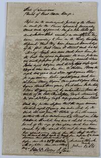
183613107East Baton Rouge Parish LA: October 25 1836. 1p. on a single folded sheet integral blank docketed on verso. Old folds moderate toning and foxing short closed tear along one fold line a few small instances of ink burn. Overall good condition. An interesting document of legal testimony involving numerous named slaves in Louisiana in 1836 ranging in age from one year to almost thirty years of age and including seven children. According to the docketing the document is effectively a "Title to Slaves." The deponents were two local citizens John Bills and Andrew Black who had "personal knowledge of the fact that James D. Stuart and his wife Mary Gayle are now and have been for the last ten years & upwards the bona fide owners and possessors of the following named slaves: Juba Aged 25 and Sicily his wife aged 22 to whom have been born the children Braxton aged six years and Dan aged 3 years. Also the negro woman Celia aged 28 years and her children Mary 11 years Margaret 8 years Charley 6 years Sarah three years which slaves Juba Sicily & Celia were acquired by inheritance from the estate of Christopher Gayle. And they further depose that the negro woman Rachel aged 17 years was inherited by the said Stuart from the estate of his deceased mother.and that the said Rachel has now a child named Jacob of the age of one year." The document is signed by Black Bills and the Justice of the Peace Daniel D. Avery. Documents involving slave inheritance of and subsequent ownership by not one but both members of a marriage are exceedingly rare. October 25 unknown
192349740New Orleans: Southern Pine Association 1923. 1923. TRADE CATALOG. Scarce early first edition of this nicely illustrated collection of plans. 9" x 12" unfolding to 18" x 12" 24 pp consisting of introductory text followed by 11 plans each accompanied by descriptive text and an illustration of the completed structure. Founded in 1915 the Southern Pine Association was a trade organization that engaged in extensive group marketing as well as in the development of standards and quality controls for the lumber industry. According to the website of the organization's current iteration the Southern Forest Products Association early members "initiated the practice of forest management in the South. These pioneers at first ridiculed for what was perceived as naive efforts slowly led the Southern lumber industry to renewed vigor." This publication aimed at "the amateur who wants to build his own garage" offers considerations for selecting a design layout and location for your garage full details of all necessary supplies and a handy table of automobile sizes apparently for the man who can build a garage but lacks the ability to measure his own car. We find no copies of this edition listed in OCLC where the earliest copy found dates from 1925. Chip missing from lower corner of front wrapper moderate general wear from use including chipping and short tears at edges one leaf detached. Stamped many times with the details of the distributing business the J. C. Dearstine Lumber Co. of Schenectady New York. Good plus copy. Southern Pine Association, [1923]. unknown
190460713Boston MA & St. Louis MO: Boston & Maine Railroad 1904. 8vo. 4 x 8 in. which folds out into 4to. 8 x 8 in. printed in double columns 40 i.e. 20 pp. photo illustrations throughout w/ 1 large folding colour “Map of the St. Louis Exposition Grounds.†Colour-illustrated softcovers minor edgewear rubbing old discrete tape repair to inner spine still VG- copy. First edition of this very scarce railroad passenger guide to the St. Louis Worlds Fair Louisiana Purchase Exposition offering photos of the exhibits and attractions. As depicted on the large folding map the Louisiana Purchase Exposition spread over 1200 acres and incorporated education into all aspects of the exhibitors. Founded originally in 1835 the Boston & Maine Railroad expanded through New England with subsidiary connections into the Great Lakes and Midwest by the 1904 World’s Fair and continued to expand ridership until after World War I. Worldcat locates 1 copy Northwestern. Boston & Maine Railroad, paperback
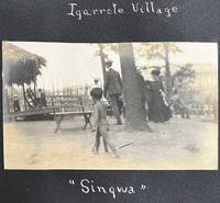
190462227St. Louis MO: n.p. 1904. Oblong 4to. 10.25 x 7 in. 24 pp unpaginated. on thick black paper stock 27 mounted silver gelatin photographs nearly all sized 3.25 x 5.5 in. annotated below or alongside in white ink manuscript. Contemporary self-printed black paper covers white lettering printed on front cover title in white ink manuscript punch-sewn at spine w/ red silk braid minor edgewear slight bumping to 1 corner minor over-exposure to some of the images still a VG exemplar. An original vernacular souvenir photo album created by an unknown amateur photographer documenting their tour of the famed 1904 St. Louis World Louisiana Exposition World’s Fair using their own camera -- typically after paying an entrance fee as inaugurated at the 1893 Columbia Exposition over 10 years before. The album opens with views of the Palace of Liberal Arts Festival Hall and the fountains Terrace of the States Electricity Palace Education and more. Along with many of the general public fair-goers these photographs reflect a fascination with the ethnological “Human Zoo†exhibits at the Exposition including the Igarrote-Filipino Village with one young child striding in the fore-ground the Philippine Restaurant and view of the Village with huts temple and walled city. Also featured are a few of the Japanese tea garden and pavilion and the Chinese temple exterior and interior. The photographer also captured the Life-Saver’s Exhibit by the Lifesaving Service; the Jefferson City Guards marching in front of the Austria & Sweden Buildings as well as the entrance to “the Pike†with visits to the Japanese Roof Garden Restaurant Beer Garden and German Coffee House. [n.p.], unknown
190460923St. Louis MO: Official Photographic Company Louisiana Purchase Exposition Co. Robert A. Reid 1904. 12mo. Die-cut heart-shaped sized 6 x 6.25 in. 49 leaves unnumbered. With 47 photo plates all w/ decorative borders. Colour-illustrated softcovers sewing hole at upper fore-edge punch-sewn w/ silk thread slight creasing to upper left fore-edge minor edgewear still a VG copy. First edition of this charming and inventive souvenir view book to the St. Louis Worlds Fair Louisiana Purchase Exposition offering a comprehensive illustrated tour to the famed event. The opening images reflect the contemporary fascination with the ethnological “Human Zoo†indigenous people’s exhibits on “The Pike†including photos of the Native Americans at the Indian Congress Philippine Igorrots dancing Singalese dancers geisha girls at the Japanese tea house the Chinese Pavilion and other exhibits. Also included are views of the Palaces of Mines & Liberal Arts Palace of Agriculture East Plaza with giant statues of Lewis & Clark the Louisiana Purchase Stock show featuring eleven prize steers the Ferris Wheel exhibit interiors and more. Worldcat loctes 7 copies CS Fresno History CO DLC U of DE Missouri Hist. Mus Bryn Mawr SMU. Official Photographic Company, Louisiana Purchase Exposition Co., Robert A. Reid, paperback
190460900St. Louis MO: N.D. Thompson Publishing Co. 1904. Oblong folio. 13.75 x 11.25 in. 2 302 2 pp. Colour frontisp. over 300 photo plates. Burgundy-coloured cloth over beveled boards black lettering on front cover ruled embossed in blind on front cover minor rubbing edgewear expertly recased a few minor paper repairs gutter margin repair still VG bright copy from the library of Prof. Marvin Nathan. First “Library edition†of this photographic guidebook to the St. Louis Worlds Fair Louisiana Purchase Exposition offering a comprehensive illustrated tour to the famed event. Exterior views the Midway the Ferris Wheel interiors of all the exhibits sporting events and more. The Louisiana Purchase Exposition spread over 1200 acres and incorporated education into all aspects of the exhibitors including blacksmiths at work Native Americans living in their villages transplanted Philippine Moro natives elephant trainers lion tamers and more. Visitors to The Pike -- the mile long midway -- could scale the Tyrolean Alps visit Blarney Castle a Parisian fashion show dive under the sea or ride a burro to Cliff Dwellings. The 1904 St. Louis Fair also featured the first Airship races contest which offered a prize if the competing airships could complete the course three times at a speed of 15 m.p.h. A photo of Hippolyte Francis’s airship Ville de St. Mande depicts the airship in flight with a 100 foot long gasbag and 35 feet in diameter. Workmen had to dig a trench to get the ship out of the aerodrome and it later crashed into the concourse fence and did not fly again. N.D. Thompson Publishing Co., hardcover
192041166Washington D.C.: Published by the United States Coast and Geodetic Survey 1920. Large folding nautical chart printed on heavy paper stock. Colored. A rare original coastal survey of the Texas-Louisiana border area along the Sabine Lake and Pass into the Gulf of Mexico encompassing a portion of the Golden Triangle Area including Port Arthur and Sabine Lake.<br/> <br/> Established by President Thomas Jefferson in 1807 as the Survey of the Coast the U.S. Coast and Geodetic Survey was the United States' first civilian scientific agency. This agency has followed its mission to survey the U.S. coastline create nautical charts of the coast and help increase maritime safety since its founding and has often played fascinating roles in significant chapters of U.S. history. It served in all theaters of the Civil War in the service of the Union Army and Navy pioneered acoustic exploration in the wake of the sinking of the Titanic and during WWI it worked to detect enemy submarines. In addition this agency worked to survey and produce detailed maps and renderings of the U.S. coast. These nautical survey maps commonly referred to as "T-sheets" provide fascinating insights into the history of the United States coastline which has and will continue to shift. These maps are the most important data source for understanding the physical and ecological characteristics of the U.S. shoreline. The present map of the Texas-Louisiana coastline is notable for the inclusion of railroad founder Arthur Stillwell's Experimental Farm outside of Port Arthur on Lake Stillwell. It is a highly detailed and accurate sea chart of the southernmost border region between Texas and Louisiana and an important historical view of the developing states. Published by the United States Coast and Geodetic Survey unknown
191941193Washington D.C.: Published by the United States Coast and Geodetic Survey 1919. Large folding nautical chart printed on heavy paper stock. Colored. A rare original coastal survey of Gulf Coast from the Rio Grande to the Mississippi River and includes Mexico Corpus Christi Galveston and New Orleans.<br/> <br/> Established by President Thomas Jefferson in 1807 as the Survey of the Coast the U.S. Coast and Geodetic Survey was the United States' first civilian scientific agency. This agency has followed its mission to survey the U.S. coastline create nautical charts of the coast and help increase maritime safety since its founding and has often played fascinating roles in significant chapters of U.S. history. It served in all theaters of the Civil War in the service of the Union Army and Navy pioneered acoustic exploration in the wake of the sinking of the Titanic and during WWI it worked to detect enemy submarines. In addition this agency worked to survey and produce detailed maps and renderings of the U.S. coast. These nautical survey maps commonly referred to as "T-sheets" provide fascinating insights into the history of the United States coastline which has and will continue to shift. These maps are the most important data source for understanding the physical and ecological characteristics of the U.S. shoreline. The present map is notable for the inclusion of an international border at the Rio Grande River as well as for showing a miniature grid of the city of New Orleans with the Radio Station notated. It is a highly detailed and accurate sea chart of the Gulf Coasts of Mexico Texas and Louisiana and is an important historical view of the developing states along the Gulf of Mexico. Published by the United States Coast and Geodetic Survey unknown
192041197Washington D.C.: Published by the United States Coast and Geodetic Survey 1920. Large folding nautical chart printed on heavy paper stock. Colored. A rare original coastal survey of Gulf Coast of Texas and Louisiana including Galveston Beaumont Sabine Lake Marsh Island Barrier Islands New Orleans Lake Pontchartrain and the Mississippi River.<br/> <br/> Established by President Thomas Jefferson in 1807 as the Survey of the Coast the U.S. Coast and Geodetic Survey was the United States' first civilian scientific agency. This agency has followed its mission to survey the U.S. coastline create nautical charts of the coast and help increase maritime safety since its founding and has often played fascinating roles in significant chapters of U.S. history. It served in all theaters of the Civil War in the service of the Union Army and Navy pioneered acoustic exploration in the wake of the sinking of the Titanic and during WWI it worked to detect enemy submarines. In addition this agency worked to survey and produce detailed maps and renderings of the U.S. coast. These nautical survey maps commonly referred to as "T-sheets" provide fascinating insights into the history of the United States coastline which has and will continue to shift. These maps are the most important data source for understanding the physical and ecological characteristics of the U.S. shoreline. The present map is starts with the city of Beaumont and the state border with Louisiana at Sabine Lake and Pass and covers the coastline until the Mississippi River past New Orleans. In the bottom left corner an enlarged map of Galveston is included. This map is a highly detailed and accurate sea chart of the Gulf Coasts of Texas and Louisiana and is an important historical view of the developing states along the Gulf of Mexico. Published by the United States Coast and Geodetic Survey unknown
1334152942.Gpaperback. Good. Access codes and supplements are not guaranteed with used items. May be an ex-library book. paperback
ria9781399536332_inpHardback. New. New Book; Fast Shipping from UK; Not signed; Not First Edition; Provides new solutions to the central problems of the philosophy of mathematics by reconstructing Deleuze’s metaphysics hardcover
1527725049.Gpaperback. Good. Access codes and supplements are not guaranteed with used items. May be an ex-library book. paperback
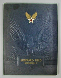
1945000016894<p>Baton Rouge: Army and Navy Publishing Company of Louisiana 1945. hardcover. near Fine . Folio 78 pages. Illustrated with black and white photo reproductions. Wings Over America United States Army Air Forces. 122615B <br /><br /></p> Army and Navy Publishing Company of Louisiana hardcover
0259479586.Gpaperback. Good. Access codes and supplements are not guaranteed with used items. May be an ex-library book. paperback
1333363958.Gpaperback. Good. Access codes and supplements are not guaranteed with used items. May be an ex-library book. paperback
1527864529.Gpaperback. Good. Access codes and supplements are not guaranteed with used items. May be an ex-library book. paperback