Louisiana State Normal CollegeBiblio.com
1 088 résultats
0331352001.Ghardcover. Good. Access codes and supplements are not guaranteed with used items. May be an ex-library book. hardcover
1390946878.Gpaperback. Good. Access codes and supplements are not guaranteed with used items. May be an ex-library book. paperback
1396414487.Ghardcover. Good. Access codes and supplements are not guaranteed with used items. May be an ex-library book. hardcover
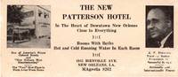
195512990New Orleans 1955. Photo-illustrated trade card 2.75 x 6.25 inches. Minor edge wear and toning horizontal crease some biopredation to bottom and right portions costing a handful of letters. Good condition. An extraordinary survival from Jim Crow Louisiana advertising the New Patterson Hotel in New Orleans owned and operated by John Robert Patterson. The hotel was the first African American-owned hotel in New Orleans and became one of the most popular during the Green Book era of African American travel. The hotel was located at two different addresses during its years of operation in which it was routinely listed in the annual publication of The Negro Traveler's Green Book. The present trade card emanates from the hotel's second location at 1815 Bienville Avenue where the hotel moved in 1954 or 1955; the hotel is listed at its first address on Rampart Street in the 1954 edition and the Bienville location by the time of the Green Book's 1955 edition.<br /> <br /> The trade card features two small photographs. At left is an image of the hotel itself with some promotional slogans beneath reading "One of America's Finest Colored Hotels and 'New Orleans Most Discriminating'" and "The 'Very' Best Place to Sleep Away from Home." The right side of the card prints a portrait of J.R. Patterson who is touted for his "Years of Business Experience in Successful Service" and "Nationally and Internationally Known." The center of the card prints information about the hotel located "In the Heart of Downtown New Orleans Close to Everything" offering "Rooms With Baths" and "Hot and Cold Running Water in Each Room" and with the address and phone number at bottom. The card is similar to the regular newspaper advertisement for the hotel printed in The Louisiana Weekly from 1956 to 1965. We could locate no other copies of this striking trade card for an important African American hotel in New Orleans founded owned and operated by a notable local businessman. unknown
B9781020623752Hardback. New. hardcover
0266997538.Gpaperback. Good. Access codes and supplements are not guaranteed with used items. May be an ex-library book. paperback
0331211424.Ghardcover. Good. Access codes and supplements are not guaranteed with used items. May be an ex-library book. hardcover
192041177Washington D.C.: Published by the United States Coast and Geodetic Survey 1920. Large folding nautical chart printed on heavy paper stock. Colored. A rare original coastal survey of Mississippi River area around the city of New Orleans.<br/> <br/> Established by President Thomas Jefferson in 1807 as the Survey of the Coast the U.S. Coast and Geodetic Survey was the United States' first civilian scientific agency. This agency has followed its mission to survey the U.S. coastline create nautical charts of the coast and help increase maritime safety since its founding and has often played fascinating roles in significant chapters of U.S. history. It served in all theaters of the Civil War in the service of the Union Army and Navy pioneered acoustic exploration in the wake of the sinking of the Titanic and during WWI it worked to detect enemy submarines. In addition this agency worked to survey and produce detailed maps and renderings of the U.S. coast. These nautical survey maps commonly referred to as "T-sheets" provide fascinating insights into the history of the United States coastline which has and will continue to shift. These maps are the most important data source for understanding the physical and ecological characteristics of the U.S. shoreline. The present map of the Louisiana coastline is notable for the inclusion of the city of New Orleans including mention of City Park and Carrollton. The map tracks the Mississippi southward to Grand Prairie. The map is a highly detailed and accurate sea chart of the New Orleans area along the Mississippi and an important historical view of developing Louisiana. Published by the United States Coast and Geodetic Survey unknown
46306392-nnew. unknown
47037133-nnew. unknown
46961000-nnew. unknown
45304507-nnew. unknown
45218764like new. unknown
0364433833.Gpaperback. Good. Access codes and supplements are not guaranteed with used items. May be an ex-library book. paperback
0364433914.Ghardcover. Good. Access codes and supplements are not guaranteed with used items. May be an ex-library book. hardcover
0266251013.Ghardcover. Good. Access codes and supplements are not guaranteed with used items. May be an ex-library book. hardcover
0483792705.Ghardcover. Good. Access codes and supplements are not guaranteed with used items. May be an ex-library book. hardcover
B9781020619779Hardback. New. hardcover
A9781017752168Hardback. New. hardcover
46380180like new. unknown
ria9781020619779_inpHardcover. New. New Book; Fast Shipping from UK; Not signed; Not First Edition; A scholarly journal devoted to the history of Louisiana and the Gulf South. This publication features articles by respected historians and researchers covering topics ranging from colonial history to contemporary culture. It is an inva hardcover
0259889849.Gpaperback. Good. Access codes and supplements are not guaranteed with used items. May be an ex-library book. paperback
B9781017752168Hardback. New. hardcover
20002-4H0881924776BRAND NEW. Gift quality. Great condition No remainder mark.2-4H Timber Press, Incorporated hardcover
1022262335.Gpaperback. Good. Access codes and supplements are not guaranteed with used items. May be an ex-library book. paperback