Zarren, FerdinandAntiquariat.de

1 080 résultats
1865916Handbuch zur schnellsten und sichersten Ermittelung der Gebühren bei Versendung von Frachten, Militär- und Eilgütern mittelst Eisenbahnen, Dampfschiffen und Strassen-Fuhrwerk. Reichenberg, Schöpfer & Waege, 1865. Gr.-8vo. (25,0 x 17,0 cm). VI, 601 S. Halbleinwandband d. Zt.
18828492Worcester 1882. Original printed wrappers stitched 14pp light wear. Very Good. Much material on the financial condition of the Company along with its Schedules of Engines and Cars and progress reports. Not in Sabin Eberstadt. unknown books
18808491Worcester 1880. Original printed wrappers stitched 14pp light wear. Very Good. Much material on the financial condition of the Company along with its Schedules of Engines and Cars and progress reports. Not in Sabin Eberstadt. unknown books
1874914Wien, Hof- u. Staatsdruckerei, 1874. Gr.-8vo. 104 S. Orig.-Umschlag.
1886522Wien, Spielhagen & Schurich, 1886. 8vo. 48 S. Orig.-Umschlag.
1861VERK0663Mannheim, Bassermann 1861. XVI, 647 S., Ln. d. Zt., gldgepr. Rückentit., berieb., vord. Gelenk beschäd., Vorsatzfalz aufgerissen, Schnitt verstaubt. Der Atlasband mit 16 Tafeln fehlt. [2 Warenabbildungen]
188510975Milwaukee WI: The Corbitt & Skidmore Co. Printers 1885. Single sheet poster 61 cm x 14 cm / 24" x 5.5" Several horizontal folds. Image and text are sharp. Fun advertisement from this short-lived railroad. The original Wisconsin Central Railroad Company 1871-1879 was a major early railroad that operated throughout northern Wisconsin. It built lines up through the forested wilderness and opened large tracts to logging and settlement. It established stations which would grow into a string of cities and towns between Stevens Point and Ashland including Marshfield and Medford and it connected these places to Chicago and St. Paul. It also played a major role in building Chicago's Grand Central Station. Despite these successes it struggled financially from the start and was bankrupt by 1879. It was leased to the Northern Pacific Railway from 1889 to 1893 and was finally reorganized from bankruptcy in 1897 as the Wisconsin Central Railway. The Corbitt & Skidmore Co. Printers unknown
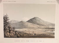
185714424Washington DC: A. O. P. Nicholson Printer 1857. First Edition. Very Good. 8.25x11in Four litho tinted illustrated plates I II VIII and XII; Some age-toning along edges one with large stain along right edge not affecting neatline of illustration. These plates are from from Volume VI of the quarto edition of twelve volumes were published from 1855 to 1861 as exploration and survey reports became available. These volumes contained not only the survey maps and elevations but a monumental collection of scientific reports on geography geology zoology botany and ethnology of the Native American tribes. The surveys also included 11 artists to record the landscape and indigenous peoples of the west. <br /> <br /> The plates were drawn in 1855 by John J. Young 1830-1879 a staff artist for the War Department. He was assigned in 1855 as a draftsman for the Lt. Williamson railway survey to connect California's Sacramento Valley with Oregon's Columbia River.Young's views of the Cascade Range included 14 landscape scenes one geologic scene and 10 drawings of trees in there habitat from Samuels p 545 <br /> <br /> The Illustrations are: Plate 1 - Lassens Butte From Vicinity of Camp 18 Plate II Mouth of Fall River near Camp 20 Plate VIII Canon of Psuc-See-Que Creek near Camp 41A Plate XII Shasta Butte and Shasta Valley from a point near Camp 70A.<br /> <br /> The twelve volumes were disorganized in publication with no overall all arrangement or indexing. Some of the plates and maps referred to in volumes were published in other volumes various reports were also published out of sequence relating to the four routes. Preliminary reports published were updated in latter volumes. From Wagner-Becker-Camp In 1853 Senator Gwin of California lead the inclusion of Congressional funding for 1853-54 of a series of surveys to determine the best and most economical railroad routes from the Mississippi River to the Pacific coast. The act directed the Secretary of War Jefferson Davis to plan and direct Army topographical engineers to conduct surveys of four routes. The first was between the 47th and 49th parallels generally along the Lewis and Clark route to the Pacific. The Second route between the 37th and 39th parallels was promoted by Senator Thomas Hart Benton of Missouri. The Third route was along the 35th parallel. The Fourth route was promoted by Secretary Davis along the 32nd parallel that followed Emory's 1846-47 reconnaissance. A. O. P. Nicholson, Printer unknown
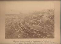
190042650Miles City Montana: Wiley Bros. Photographers Successors to L. A. Huffman 1900. Photograph. Very Good. Large format photograph 18.5 x 24 cm on a tan mount 25 x 30 cm. Wiley Bros. backstamp "Wiley Bros. Photographers Successors to L. A. Huffman. Miles City - Montana.". Mount edges are lightly bumped and chipped. Photograph is gently rubbed and lightly faded but still showing good detail and contrast. Shows many workers constructing the bridge with Northern Pacific Railroad cars visible in the background. Photograph taken from above looking down. In ink by hand on the front of the mount "Progress showing detail of bench walls of Culvert detail of brick arch; also general view of Coulee Bridge 148. Yellowstone Riv. River. Wiley Bros., Photographers, Successors to L. A. Huffman unknown
188026813New York 1880. 20pp stitched in original printed title wrappers lightly worn. About Very Good.<br/><br/> With financial information and a "description of the country through which the Line passes" including the principal points between Wheeling and Toledo with branch to Sandusky. unknown books
189525973Paris Imprimerie Nationale 1895 GRAND In-8 Cachets de Bibliothèque 316 pp et XXVI planches , certaines déchirées sans manque
186820232ABLeipzig, Brockhaus, 1868. 8°. (1) Bl., XII, 290 (1) S. Mit 1 gef. Tabelle u. 1 gef. Tafel. Halblederbd. d. Zt. mit Rückenvergoldung u. goldgepr. Rückentitel + Wichtig: Für unsere Kunden in der EU erfolgt der Versand alle 14 Tage verzollt ab Deutschland / Postbank-Konto in Deutschland vorhanden +, 20232A (stärker berieben u. bestossen).
1836016450Boston: Dutton & Wentworth Printers 1836. Book. Very good condition. Hardcover. First Edition. Octavo 8vo. A bound volume containing a collection of ten publications relating to the Western Rail-Road Corporation from the incorporation in 1836 to 1840. The First Annual Report from 1836 is included twice. Bound in contemporary original three quarter leather which is moderately to heavily worn with the front board nearly detached. There is minor to moderate foxing and the final half of the text is lightly stained at the top corner. The 1836-37 Reports of the Engineers is complete with two fold-out maps which were printed on very thin onion-skin paper. These two maps have been detached and are misfolded with minor tearing as well as some foxing. A ready-made collection of the founding documents of this railroad company which starts in Boston winding its way across the state where it enters New York State at West Stockbridge. Dutton & Wentworth, Printers Hardcover books
1836016450Boston: Dutton & Wentworth Printers 1836. Book. Very good condition. Hardcover. First Edition. Octavo 8vo. A bound volume containing a collection of ten publications relating to the Western Rail-Road Corporation from the incorporation in 1836 to 1840. The First Annual Report from 1836 is included twice. Bound in contemporary original three quarter leather which is moderately to heavily worn with the front board nearly detached. There is minor to moderate foxing and the final half of the text is lightly stained at the top corner. The 1836-37 Reports of the Engineers is complete with two fold-out maps which were printed on very thin onion-skin paper. These two maps have been detached and are misfolded with minor tearing as well as some foxing. A ready-made collection of the founding documents of this railroad company which starts in Boston winding its way across the state where it enters New York State at West Stockbridge. Dutton & Wentworth, Printers Hardcover
190051798Chicago: Curt Teich & Co. for the Van Noy Inter-State Co 1900. Oblong 4to unpaginated; 25 full-pg illustrations in color and mounted two pages of text containing illustration descriptions; tan pictorial wrappers lettered in black & gilt color illustration mounted on upper cover ribbon-bound; covers a bit toned at edges corners creased illustrations clean & bright overall very good. A picturesque view-book of "the most interesting views seen along the route" of Utah Nevada and California. <br/><br/> Curt Teich & Co. for the Van Noy Inter-State Co unknown books
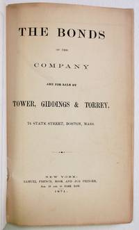
187129188New York: Samuel French 1871. Original green printed wrappers wrapper title: 'The First Mortgage Land Grant Sinking Fund Seven Per Cent Gold Bonds Principal and Interest Payable in Gold Free of Government Tax. Of the West Wisconsin Railway'. Stitched. 14 2 blanks pp. Folding 'Map of Wisconsin Rail Road and Its Connections' @14" x 16". Tear at bound edge of folding map repaired with short piece of scotch tape. Very Good. <br/><br/> The Map by Henry Seibert of New York prominently shows the West Wisconsin line from St. Paul MN to Tomah WI; tracks other railroads in Minnesota Wisconsin and Iowa; and depicts Lakes Michigan and Superior and Green Bay. The Road is described and the investment recommended. A rare item OCLC locating only the copy at the University of Missouri. <br/>FIRST EDITION. OCLC 41200220 1 as of June 2021. Not in Eberstadt Decker Sabin Soliday Graff Modelski. Samuel French unknown books
187129188New York: Samuel French 1871. Original green printed wrappers wrapper title: 'The First Mortgage Land Grant Sinking Fund Seven Per Cent Gold Bonds Principal and Interest Payable in Gold Free of Government Tax. Of the West Wisconsin Railway'. Stitched. 14 2 blanks pp. Folding 'Map of Wisconsin Rail Road and Its Connections' @14" x 16". Tear at bound edge of folding map repaired with short piece of scotch tape. Very Good. <br /> <br /> The Map by Henry Seibert of New York prominently shows the West Wisconsin line from St. Paul MN to Tomah WI; tracks other railroads in Minnesota Wisconsin and Iowa; and depicts Lakes Michigan and Superior and Green Bay. The Road is described and the investment recommended. A rare item OCLC locating only the copy at the University of Missouri. <br /> FIRST EDITION. OCLC 41200220 1 as of June 2021. Not in Eberstadt Decker Sabin Soliday Graff Modelski. Samuel French unknown
18594574Grundzüge für ihre Constructions-Verhältnisse. Mit 38 Textholzschnitten. Göttingen, Vandenhöck & Ruprecht, 1859. 8vo. (20,4 x 12,5 cm). VI, 152 S. Halbleinwandband d. Zt.
1869938DBWeimar, Voigt, 1869. 8°. VIII, 232 S. Leinenband der Zeit + Wichtig: Für unsere Kunden in der EU erfolgt der Versand alle 14 Tage verzollt ab Deutschland / Postbank-Konto in Deutschland vorhanden + (stärker berieben und bestossen, fleckig).
1873503Kritische Erörterungen auf ausgeführten Bahnen gesammelter Thatsachen. Mit 4 gefalt. Tabellen. Weimar, B. F. Voigt, 1873. 8vo. (21,2 x 13,2 cm). XVIII, 124 (recte 123) S., 1 Bl. Anzeige. Halblederband d. Zt. mit etwas Rückenvergoldung.
1877917II. u. VII. Heft [von 7 Heften]. Wien, Pest u. Leipzig, A. Hartleben, 1876 u. 1877. Gr.-8vo. Ohne Einbände.
1869938DBWeimar, Voigt, 1869. 8°. VIII, 232 S. Leinenband der Zeit (stärker berieben und bestossen, fleckig).
18641398638th Cong. 1st Sess.: SMD11. 1864. 6 2 blanks pp. Disbound and Very Good. SMD11. unknown books
1880547Nach den Quellen dargestellt. Bern, K. J. Wyss, 1880. Gr.-8to. (24,0 x 16,5 cm). VII, 458 S., 1 Bl. Verbesserungen. Orig.-Umschlag.
18855898BBLuzern, J. Bujrkhardt, 1885. 8°. (2), VIII, 648 S. Halblederbd. d. Zt. mit goldgepr. Rückenschildern + Wichtig: Für unsere Kunden in der EU erfolgt der Versand alle 14 Tage verzollt ab Deutschland / Postbank-Konto in Deutschland vorhanden +, 5898BB