[JAPANESE MAP OF NORTHERN CHINA].Biblio.com
10 016 résultats
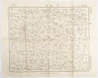
1938172168Japan.: 陸地測量部参謀本部. Rikuchi Sokuryōbu Sanbō Honbu. Showa 13 1938. Black and white folded map 45.5 x 57.5 cm scale 1:50000 Two small red pencil marks and one in blue some careless folding of map but overall very good. This 1938 map of northern China was published in 1938 by the General Staff Headquarters of the Japanese Army and was marked as military secret. By this time Japanese military was fighting in China in various regions. This military map shows parts of 單縣 Shan County in Shandong Province 虞城縣 Yucheng County in Hennan Province and 碭山縣 Dangshan County in Jiangsu Province. . 陸地測量部参謀本部. [Rikuchi Sokuryōbu Sanbō Honbu]. unknown
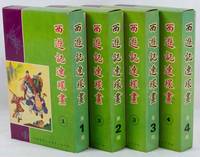
1975223379Hong Kong.: 新雅七彩畫片公司. Xinya qicai huapian gongsi. 1975. Forty volume graphic novel set of Journey to the West complete illustrated in black and white with captions in traditional Chinese characters below. Presented in 4 boxes of 10 volumes each approximately 44 - 60pp per volume 20.2 x 12.5cm. Coloured paper wrappers each with its own title and list of all titles on lower wrapper. Wrappers slightly foxed a little soiling on boxes but overall the set is in exceptionally good condition. A very appealing graphic lianhuanhua set of Wu Cheng'en's famous novel Journey to the West sometimes translated as "Monkey". . 新雅七彩畫片公司. [Xinya qicai huapian gongsi]. unknown
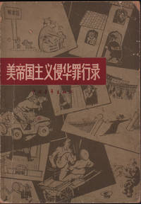
1966220355Beijing.: 中国青年出版社 Zhongguo qingnian chubanshe. 1966. Black and white photographic and black line drawn illustrations 149pp text in simplified Chinese characters 18.5 x 13cm paper wrapper. Evenly browned throughout worn and soiled wrappers chipped at corners and head and tail of spine. . 中国青年出版社 [Zhongguo qingnian chubanshe]. unknown
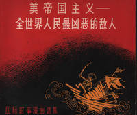
1963216946Beijing.: 世界知识出版社. World Knowledge Publishing House. 1963. Black and white line satirical cartoons throughout 97pp text in simplified Chinese characters 17.5 x 19cm. Leaves slightly browned original pictorial paper wrappers lightly worn very good condition. . 世界知识出版社. [World Knowledge Publishing House]. unknown
192941261上海市 Shanghai: æ£è—社 Zheng yi she 1929. Second edition. Softcover. poor to vg-. Folios. Approx. 15x10". Unpaginated. "Modern" volume with 3 preliminary pages of index and 8 pages of prologue. "Ancient" volume with 2 pages of prologue and 1 page of index at the front. Grey patterned cloth portfolio with black lettering over a white label on the front cover. Light blue-grey silk wrappers with light blue string-tied bindings. Red lettering in English and Chinese over a tan silk label on the front covers. This is the "November 1929" printing.<br /> <br /> The work is an exhibition catalog from The National Fine Arts Exhibition held in Shanghai in April of 1929 which was organized by the Ministry of Education of the Republic of China headed at the time by Cai Yuanpei. It is considered the first Chinese fine arts exhibition in modern history. The exhibition was a monumental retrospective with more than 2000 pieces of art from throughout Chinese history starting from the Five Dynasties period the 10th century up through the contemporary period. The event brought together the work of countless Chinese artists photographers and architects and also included the work of six Japanese artists. <br /> <br /> The catalog includes some 400 pieces of the artwork featured in the exhibition divided into a "modern" volume and an "ancient" volume. The artwork is printed in b/w offset photographic reproductions and collotypes. Also included in the "ancient" volume are seven works in color with both Chinese and English language titles on protective tissue guards a few of which are beautifully printed color lithographs. The "modern" volume contains a printed calligraphic prologue written in by Cai Yuanpei. The "ancient" volume includes works from some artists as The Four Wangs Wu and Yun from Qing Dynasty Four Monks of the Early Qing Dynasty Bada Shanren Shitao Hong Ren and Kun Can Lan Ying and Gong Xian. The "modern" volume contains works from Zhang Daqian Qi Baishi Wu Hufan Liu Haisu and Lin Fengmian among many others. Both volumes contains extensive indexes of the artwork. Text in Chinese.<br /> <br /> Portfolio with boards broken but present. Wrappers with some light smudges and scratches and a few minor creases. Some sunning along the top and bottom edges of the covers. Interiors with sunning to the edges and a few sporadic minor smudges. Images mostly unaffected. Portfolio in poor wrappers in good interiors in very good- condition overall. æ£è—社 (Zheng yi she) unknown
1945213507美國自由畫報社.【Meiguo zi you hua bao she. May 5th & May 10th1945. Scarce ephemera from the Pacific WWII China theater. Two page APO 627 Army Post Office 627 Kunming China typescript English language document 34 x 22.5cm dated May 10th 1945 together with a small news leaflet 14 x 11cm dated 5 days earlier with the same text in Chinese printed on both sides. The size of the Chinese leaflet suggests it was designed to be dropped from aircraft over Occupied China. The feature article is titled "Hitler is dead" in English and in Chinese 希特勒死了! The other news: Mussolini Executed After Trial by People's Tribunal; Rangoon Freed of Japanese and San Francisco Conference in Session. <br> <br>The English language document appears to have been written as the file copy to accompany the Chinese news release/newsletter. The information at the top of the first page gives details of the Target audience: Occupied China as well as Leaflet ident cation number - "OWI/CN-109"; Language - "Chinese"; Time: "Immediately" and Purpose: "To report the latest developments in the European and Pacific theatres of war to the Chinese in Occupied territory and give them news of the progress of the San Francisco Conference". <br> <br>A little creasing pin holes and tiny tears at edges of the evenly browned English language document the Chinese leaflet lightly foxed. Overall very good. . 美國自由畫報社.【Meiguo zi you hua bao she]. unknown
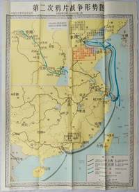
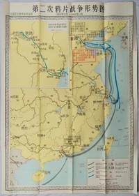
1980216471Shanghai.: 地图出版社.Map Press. First Edition. 1980. Colourful folding teaching reference wall map of China during the Second Opium War October 1956 - November 1860. Includes an inset at top left of the route that French and British invaders took in 1860 and a key at bottom right explaining the dates of different invasion routes. Text boxes explain key events. Original wrapper creased on top edge with a red "山东济南第五十." stamp. Bottom right corner of map very slightly worn else in excellent bright crisp condition. 106 x 76cm. Text in simplified Chinese characters. . 地图出版社.[Map Press]. unknown
1980216702Shanghai.: 地图出版社.Map Press. First Edition. 1980. Colourful folding educational wall map of China during the Second Opium War October 1956 - November 1860. Includes an inset at top left of the route that French and British invaders took in 1860 and a key at bottom right explains the dates of different invasion routes. Text boxes explain key events. Original wrapper repaired with cellotape and washi paper. Bottom right corner of map very slightly worn else in excellent bright crisp condition. 106 x 76cm. Text in simplified Chinese characters. . 地图出版社.[Map Press]. unknown
19886061988 - broché - Peking University Press - 1988 - In-12 (18 x 11 cm) broché, couverture à rabats - 241 pages - Illustrations et photographies en noir et blanc - Quelques cartes dépliantes - ISBN : 7-301-00453-2 - Traduction de Wang Mingzhu & Meg Gallagher - Textes en anglais et en chinois - ENGLISH: Peking University Press - 1988 - In-12 (18 × 11 cm) softcover with flaps - 241 pages - Black-and-white illustrations and photographs - Includes some fold-out maps - ISBN: 7-301-00453-2 - Translated by Wang Mingzhu & Meg Gallagher - Texts in English and Chinese - 中文:北京大学出版社 — 1988年 — 12开(18 × 11厘米)平装折口封面 — 241页 — 黑白插图及照片 — 附若干折叠地图 — ISBN 7-301-00453-2 — 译者:王明珠、Meg Gallagher — 中英文对照
1934159936No publication details. circa1934. Complete Part Three of the "General History of Qing Dynasty" 清代通史 in 2 volumes by the modern Chinese historian Xiao Yishan 1902-1978. This work is made up of 10 chapters which focuses on the Boxer Rebellion and Chinese Qing government's politics and foreign affairs. Volume I: 38 124 228 280pp. Volume II: 497 130pp. Rebound in modern cloth boards titled in gilt on the spine. Upper wrapper with title and list of contents of both volumes laid down with some loss not affecting the text 8 pages of volume 2 p.123-130are also laid down. Title of volume one gives the incorrect information of the volume number whereas on the spine the correct volume number is shown. Browned throughout with occasional tears and minor loss. A stamp in the set which says "Complete set two volumes cost four Dayang " silver coins which were in use as Chinese currency suggests the books were published and sold during Chinese Minguo period 1911-1949. Text in traditional Chinese. "General History of the Qing Dynasty" was written and published over almost a decade from 1923 to 1930. The first part was first published in 1923 while Xiao Yishan 1902-1978 was still a student at Peking University. <br> <br>This two volume set is the third part of the series and is Xiao's lecture notes from the period he was lecturing at Peking Political College of Culture and History 北平文史政治學院 between 1928 and 1930. He was the founder and principal of the college. Volume one lists very detailed information on the Qing imperial officials both local and central governments and also presents famous Qing scholars' origin and major works. Volume two focuses on the rising and falling of Taiping Rebellion movement in China and also covers the political history under the reign of Tongzhi Emperor 1861-1875 . No publication details. hardcover
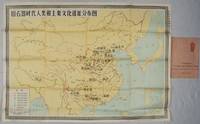
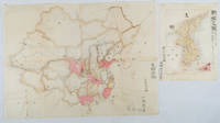
1981216685Shanghai.: 地图出版社. Map Publishing House. Reprint. 1981. Edited by 中国历史博物馆 Zhongguo lishi bowuguan. Folding educational history wall chart of important locations in early middle and late human fossil and Stone Age cultural sites in China. Inset map of all the islands claimed by China in South China Sea bottom right. Key at bottom left. Margins slightly browned as is one panel on reverse though map image unaffected. In very good crisp condition with decorative wrapper slightly chipped lower left corner. 75 x 106cm text in simplified Chinese characters. . 地图出版社. [Map Publishing House]. unknown
1902220266Japan. No date. Circa1902. Two very attractive colour folded manuscript maps one showing China and the other Korea. <br> <br>Map of China: Watercolour map 48 x 63.5cm. Closed tear now professionally repaired. <br> <br>Map of Korea: Finely detailed watercolour map a few tiny holes very neatly repaired on the verso with archival washi. 33 x 24.5cm Two delicate hand-painted maps one of China and one of Korea produced by a Japanese student cartographer named Koike Tokushige 小池徳重. <br> <br>The undated map of China appears to have been produced in the first five years of the twentieth century: a time when Japan had recently colonized Taiwan and when Japanese economic and political interest in the region was rapidly expanding. The inscription on the map suggests that it was a third year college project. But the high level of detail suggests that the artist had considerable experience of map making. The map of China shows the main provinces rivers major transport routes the Great Wall and the location of key cities although the names of the cities are not included. It also shows outlines of the Korean Peninsula Taiwan and the Japanese island of Kyushu but not the rest of Japan. <br> <br>The map of Korea is more detailed. It provides an accurate outline of the Korean Peninsula with careful hatching indicating changes in elevation. Rivers and major road routes are shown on the map and the locations of major towns are marked though only Busan and Incheon are named. Dotted lines show coastal sea routes and routes between Kyushu and Busan and between Incheon and China. The map shows the Gyeongin railway line between Seoul and Incheon which was completed in 1899 and route of the Gyeongbu railway line between Busan and Seoul whose construction started from both ends in 1901. But the map depicts only small sections of this line close to Seoul and Busan as being completed with the rest more lightly outlined to show the projected route implying that the map was drawn around 1901-1902 and certainly before the Gyongbu line was opened in 1904. <br> <br>Inserted text gives the land area and population of Korea. Rather strangely though the figure given for the Korean population is vastly underestimated. Ikeda gives this as 5.7 million when in fact at that time is was around 18 million. . unknown
1905217437Guangdong.: 廣東省香山縣梅溪鄉陳門容氏敬刊. 1905. Buddhist philosophical text ii 53 folded pages woodblock print from the Guangxu era. Browned throughout upper corners worn with loss some washi repairs original wrappers worn and torn with considerable loss to upper cover. Upper wrapper torn with loss however title page and Chinese four-hole stab binding is intact. Slight bleeding of wrapper colour onto the first few pages only. Text complete. 21.8 x 13.2cm. . 廣東省香山縣梅溪鄉陳門容氏敬刊. unknown
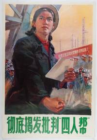
1977215861Beijing.: 人民美术出版社. People's Fine Arts Publishing House. 1977. Large anti-Gang of Four propaganda poster featuring a heroic young female worker in an industrial setting. Some lightly browned holes along upper edge of poster. In very good condition colours fresh and bright. 77 x 53cm. Poster was designed by Sun Quan 孙荃 who was assigned to the People's Fine Arts Publishing House in 1973. The background banner calls for people to swear to struggle together to the end against the anti-Party group of Wang Zhang Jiang and Yao. . 人民美术出版社. People's Fine Arts Publishing House. unknown
1936216107Qi 昌亞新地學社. Minguo 25 1936. A very attractive colour folding map of Guangdong province including inset maps of Guangzhou Shantou the European concessions of Hong Kong and Macau as well as Hainan the Paracel Islands and South China Sea. Scale of 1:1300000. Divided into eight panels measuring 54.5 x 79cm. Little light browning tide mark left margin barely intruding into printed image few tiny chips at extremities mended on reverse with washi in few places though overall in very good condition. A curious and colourful map of Guangdong issued towards the end of the Nanjing decade detailing the province's local political divisions its infrastructure such as roads railways and telegraph lines as well as its topography through stylised mountain ranges ridges and passes. <br> <br>Inset maps of Hong Kong and Macau noted as foreign concessions alongside maps of the South China Sea and Paracel Islands ostensibly affirms the status of these territories as rightful components of Guangdong in the view of the Kuomintang Government. . [Qi?] 昌亞新地學社. unknown
19956771995 - broché - Éditions des Beaux-Arts du Hebei et Académie Centrale des Beaux-Arts de Chine - Collection « Art du croquis et enseignement » - Deuxième tirage : 1995 - In-4 (28,5 x 21 cm) broché, couverture à rabats et plats cartonnés - 60 pages - Très nombreuses illustrations en noir et blanc - ISBN : 7-5310-0578-6 - Ouvrage en chinois - ENGLISH: Hebei Fine Arts Publishing House and Central Academy of Fine Arts - Make the Best of a Mistake: Wang Huaxiang's Sketch Art - "Sketch Art and Teaching" Series - Second printing: 1995 - Quarto (28.5 × 21 cm), paperback with flaps and stiff card covers - 60 pages - Very numerous black-and-white illustrations - ISBN: 7-5310-0578-6 - Text in Chinese - 中文:河北美术出版社、中央美术学院出版 - 《素描艺术与教学》丛书 - 《将错就错:王华祥的素描艺术》 - 1995年第二次印刷 - 16开(28.5 × 21厘米)平装,带折页封面及硬纸板书面 - 60页 - 大量黑白插图 - ISBN 7-5310-0578-6 - 中文版
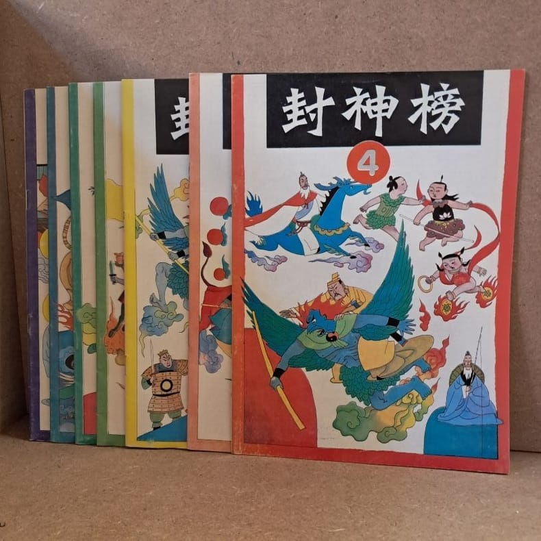
19905981990 - agrafé - Shanghai People's Fine Arts Publishing House - Imprimé en Chine (Shanghai Printing Factory No. 10) - Premières éditions - 1990 - 7 volumes in-4 (26 x 18,5 cm) brochés par agrafage - 32 pages par numéro - Feng YINAN & Lu HUA (Illustration de couverture) - Wang MING, Lu CHENGHUA, Zeng MING, Gu BAOCHENG, Wang YUEQIANG & Chen AKANG (Illustrations) - Qian ZHIQING & Le MINGXIANG (Rédacteurs en chef) - Differents ISBNs : 7-5322-0783-8 / 7-5322-0784-6 / 7-5322-0785-4 / 7-5332-0786-2 / 7-5322-0787-0 / 7-5322-0788-9 / 7-5322-0789-7 - ENGLISH : Investiture of the Gods - Printed in China (Shanghai Printing Factory No. 10) - First editions - 1990 - 7 quarto volumes (26 × 18.5 cm), saddle-stitched - 32 pages per issue - Feng Yinan & Lu Hua (Cover illustrations) — Wang Ming, Lu Chenghua, Zeng Ming, Gu Baocheng, Wang Yueqiang & Chen Akang (Illustrations) — Qian Zhiqing & Le Mingxiang (Editors) - 中文:中国印刷(上海市印刷十厂)— 上海人民美术出版社出版 — 1990年7月第一版第一次印刷 — 7册四开本(26 × 18.5厘米),骑马钉装订 — 每册32页 — 封面绘画:冯忆南、陆华 — 插图:王明、鲁成华、曾明、谷宝成、汪跃强、陈阿康 — 责任编辑:钱志清、乐明祥。
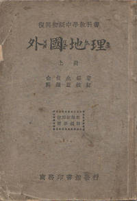
1933164732上海.Shanghai.: 商務印書館 Shang wu ying shu guan. 1st Edition. 民国22 1933. Volume 1 only of 2 maps black and white illustrations 140pp geography textbook for high school students. Original wrappers marked and worn with minor loss in places including along spine occasional ink marking and pencilling sound copy. Text in traditional Chinese. 18.7 x 12.8cm. This geography text was written under the curriculum guidance of the Education Department in 1933. The Volume One includes geography and climate information on Asia and Europe. . 商務印書館 Shang wu ying shu guan unknown
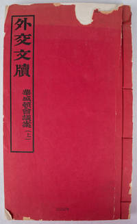
1923170115Peking.: 外交部. Wai jiao bu. December1923. Volume One only of three. 4 108 leaves four-hole stab binding in red paper covers. Original red wrappers a little faded in places and chipped and torn with some loss. Title pages some occasional foxing but generally very clean small numeric stamp upper wrapper barely visible light damp stain outer edge last leaves 4 x 3cm loss to paper on title page not affecting the text very clean and sound internally. Text in traditional Chinese. 32.6 x 19.2cm. Scarce. This conference also known as The Washington Naval Conference; The Washington Arms Conference or the Washington Disarmament Conference was a meeting of delegates from nine nations - the USA Japan China France Britain Italy Belgium the Netherlands and Portugal. This group which very deliberately excluded Russia met in this interesting post WWI world to discuss and negotiate their interests in the Pacific and the East Asian region. Three major treaties were some of the results of the conference: Four-Power Treaty; Five-Power Treaty also known at the Washington Naval Treaty and the Nine-Power Treaty together with a number of other smaller agreements. These treaties helped keep the peace throughout the 1920s and also helped Japan build up her navy and work on consolidating her position in China. The decisions and actions that took place at this conference clearly had an effect on the lead up to World War II in East Asia and it can be argued still have echoes today on relationships with and within the region today. . 外交部. [Wai jiao bu]. unknown
19926071992 - cartonné - L'Atelier Productions Pte Ltd., Singapour - 1992 - In-folio (37 x 27 cm) reliure cartonnée, sous jaquette de l'éditeur - 160 pages - Très nombreuses illustrations en couleurs et photographies en noir et blanc - ISBN : 981-00-3288-9 - Chua Soo BIN (Directeur de la publication) - Textes en anglais et en chinois - ENGLISH: L'Atelier Productions Pte Ltd., Singapore - 1992 - Folio (37 × 27 cm) hardcover binding with publisher’s dust jacket - 160 pages - Numerous colour illustrations and black-and-white photographs - ISBN: 981-00-3288-9 - Chua Soo Bin (chief editor and photographer) - Texts in English and Chinese - 中文:L'Atelier Productions Pte Ltd.,新加坡 — 1992年 — 大开本(37 × 27厘米)精装本,附出版社原装护封 — 160页 — 大量彩色插图及少量黑白照片 — ISBN 981-00-3288-9 — 主编、摄影:蔡斯民(Chua Soo Bin) - 中英文对照
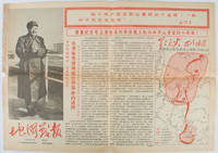
1967169746Beijing.: 地图戰報.Di tu zhan bao. September1967. Maps printed in red and black single sheet printed on both sides folded scale not given photographic image of Mao Zedong. Some light browning at edges with tears and losses on left edge still good. Text in Chinese. Sheet measures 26.5 x 38.4cm. Includes a map of Autumn Harvest Uprising and also shows the routes of the military advancing towards Jinggangshan between September and October 1927. On reverse left section a map shows the route along which Chairman Mao led the Fourth Army of the Chinese Red Army marching towards south of Anhui and Jiangxi Provinces in 1929. On reverse right section a map titled "The Long March of The Chinese Workers' and Peasants' Red Army October 1934-October 1935". Quotations of Chairman Mao about the Long March insert on corners of the map. <br> <br>Issue no. 6 of a series of maps with text issued by the Red Guards organisations in the form of Cultural Revolution tabloid-sized newspaper. This issue is designed to celebrate the 40th anniversary of the Autumn Harvest Uprising which was one of the earliest armed uprisings organised by the Chinese Communist Party. . 地图戰報.[Di tu zhan bao]. unknown
1934172781上海.Shanghai.: 廣學會.Guang xue hui. 3rd edition. 1934. 2 volumes. Maps small sheet of colour illustrations of Bible stories loosely inserted in paper pocket in volume II lacks illustrated sheet from rear pocket of volume I sheet music in number notations accompanied by lyrics. Volume I: 6 144pp; Volume II: 6 121pp. A prior owner's signature upper covers wrappers stained and marked evenly browned throughout paper on spines trifle chipped a sound set in original wrappers. Text in traditional Chinese. 18.7 x 13cm. These two textbooks were published for fifth year Sunday School students. They are into 5 sections: Jesus the Hero of Heroes; Paul the first hero that preached to foreign lands; preaching to all nations; Christian movement in China; summer life. Each lesson contains a story discussion picture and a motto or song. . 廣學會.[Guang xue hui]. unknown
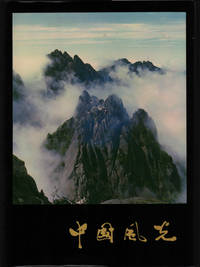
1980217464Beijing.: China Pictorial. 1980. Map indicating the location of all images photographed very striking full page colour photographic illustrations throughout captioned in Chinese and English 211pp list of contents in both Chinese and English. Foreword by Lao Chengzhi the onetime President of the Beijing Foreign Language Institute who later in life played a significant role in restoring China's relations with Japan. Text in simplified Chinese characters. Book in excellent condition as is pictorial dustjacket embossed card slip case slightly foxed in places very good copy. 38 x 26.5cm. The dramatic scenery from Xinjiang in the northwest to Fujian in the southeast and from Heilongjiang in the north to Yunnan in the south is conveyed in exquisite double page photgraphic illustrations on glossy paper including a number of aerial shots taken in all four seasons and varied weather conditions. According to Liao Chengzhi who wrote the foreword the book was published as a contribution to the development of China's tourist undertakings and as a celebration of the 30th anniversary of the establishment of the PRC. . China Pictorial. unknown
1982117244Shanghai 中國上海人民美術出 [Musée d'art populaire de Shanghai] 1982 1 vol. relié in-4, cartonnage sous jaquette, étui illustré, 217 pp., nombreuses photos en couleurs. Texte en chinois. Très bon état.
1982117244Shanghai 中國上海人民美術出 [Musée d'art populaire de Shanghai] 1982 1 vol. relié in-4, cartonnage sous jaquette, étui illustré, 217 pp., nombreuses photos en couleurs. Texte en chinois. Très bon état.