[JAPANESE MAP OF NORTHERN CHINA].Biblio.com
25 870 résultats
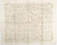
1938172168Japan.: 陸地測量部参謀本部. Rikuchi Sokuryōbu Sanbō Honbu. Showa 13 1938. Black and white folded map 45.5 x 57.5 cm scale 1:50000 Two small red pencil marks and one in blue some careless folding of map but overall very good. This 1938 map of northern China was published in 1938 by the General Staff Headquarters of the Japanese Army and was marked as military secret. By this time Japanese military was fighting in China in various regions. This military map shows parts of 單縣 Shan County in Shandong Province 虞城縣 Yucheng County in Hennan Province and 碭山縣 Dangshan County in Jiangsu Province. . 陸地測量部参謀本部. [Rikuchi Sokuryōbu Sanbō Honbu]. unknown
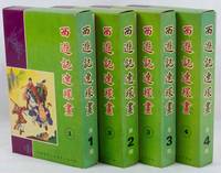
1975223379Hong Kong.: 新雅七彩畫片公司. Xinya qicai huapian gongsi. 1975. Forty volume graphic novel set of Journey to the West complete illustrated in black and white with captions in traditional Chinese characters below. Presented in 4 boxes of 10 volumes each approximately 44 - 60pp per volume 20.2 x 12.5cm. Coloured paper wrappers each with its own title and list of all titles on lower wrapper. Wrappers slightly foxed a little soiling on boxes but overall the set is in exceptionally good condition. A very appealing graphic lianhuanhua set of Wu Cheng'en's famous novel Journey to the West sometimes translated as "Monkey". . 新雅七彩畫片公司. [Xinya qicai huapian gongsi]. unknown
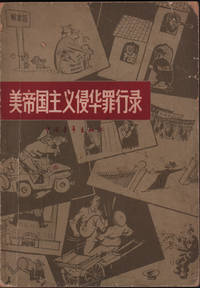
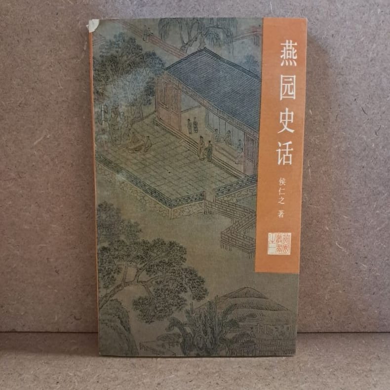
1966220355Beijing.: 中国青年出版社 Zhongguo qingnian chubanshe. 1966. Black and white photographic and black line drawn illustrations 149pp text in simplified Chinese characters 18.5 x 13cm paper wrapper. Evenly browned throughout worn and soiled wrappers chipped at corners and head and tail of spine. . 中国青年出版社 [Zhongguo qingnian chubanshe]. unknown
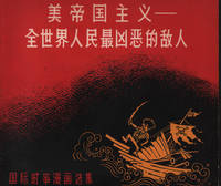
1963216946Beijing.: 世界知识出版社. World Knowledge Publishing House. 1963. Black and white line satirical cartoons throughout 97pp text in simplified Chinese characters 17.5 x 19cm. Leaves slightly browned original pictorial paper wrappers lightly worn very good condition. . 世界知识出版社. [World Knowledge Publishing House]. unknown
192941261上海市 Shanghai: æ£è—社 Zheng yi she 1929. Second edition. Softcover. poor to vg-. Folios. Approx. 15x10". Unpaginated. "Modern" volume with 3 preliminary pages of index and 8 pages of prologue. "Ancient" volume with 2 pages of prologue and 1 page of index at the front. Grey patterned cloth portfolio with black lettering over a white label on the front cover. Light blue-grey silk wrappers with light blue string-tied bindings. Red lettering in English and Chinese over a tan silk label on the front covers. This is the "November 1929" printing.<br /> <br /> The work is an exhibition catalog from The National Fine Arts Exhibition held in Shanghai in April of 1929 which was organized by the Ministry of Education of the Republic of China headed at the time by Cai Yuanpei. It is considered the first Chinese fine arts exhibition in modern history. The exhibition was a monumental retrospective with more than 2000 pieces of art from throughout Chinese history starting from the Five Dynasties period the 10th century up through the contemporary period. The event brought together the work of countless Chinese artists photographers and architects and also included the work of six Japanese artists. <br /> <br /> The catalog includes some 400 pieces of the artwork featured in the exhibition divided into a "modern" volume and an "ancient" volume. The artwork is printed in b/w offset photographic reproductions and collotypes. Also included in the "ancient" volume are seven works in color with both Chinese and English language titles on protective tissue guards a few of which are beautifully printed color lithographs. The "modern" volume contains a printed calligraphic prologue written in by Cai Yuanpei. The "ancient" volume includes works from some artists as The Four Wangs Wu and Yun from Qing Dynasty Four Monks of the Early Qing Dynasty Bada Shanren Shitao Hong Ren and Kun Can Lan Ying and Gong Xian. The "modern" volume contains works from Zhang Daqian Qi Baishi Wu Hufan Liu Haisu and Lin Fengmian among many others. Both volumes contains extensive indexes of the artwork. Text in Chinese.<br /> <br /> Portfolio with boards broken but present. Wrappers with some light smudges and scratches and a few minor creases. Some sunning along the top and bottom edges of the covers. Interiors with sunning to the edges and a few sporadic minor smudges. Images mostly unaffected. Portfolio in poor wrappers in good interiors in very good- condition overall. æ£è—社 (Zheng yi she) unknown
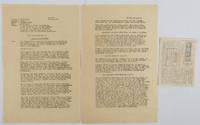
1945213507美國自由畫報社.【Meiguo zi you hua bao she. May 5th & May 10th1945. Scarce ephemera from the Pacific WWII China theater. Two page APO 627 Army Post Office 627 Kunming China typescript English language document 34 x 22.5cm dated May 10th 1945 together with a small news leaflet 14 x 11cm dated 5 days earlier with the same text in Chinese printed on both sides. The size of the Chinese leaflet suggests it was designed to be dropped from aircraft over Occupied China. The feature article is titled "Hitler is dead" in English and in Chinese 希特勒死了! The other news: Mussolini Executed After Trial by People's Tribunal; Rangoon Freed of Japanese and San Francisco Conference in Session. <br> <br>The English language document appears to have been written as the file copy to accompany the Chinese news release/newsletter. The information at the top of the first page gives details of the Target audience: Occupied China as well as Leaflet ident cation number - "OWI/CN-109"; Language - "Chinese"; Time: "Immediately" and Purpose: "To report the latest developments in the European and Pacific theatres of war to the Chinese in Occupied territory and give them news of the progress of the San Francisco Conference". <br> <br>A little creasing pin holes and tiny tears at edges of the evenly browned English language document the Chinese leaflet lightly foxed. Overall very good. . 美國自由畫報社.【Meiguo zi you hua bao she]. unknown
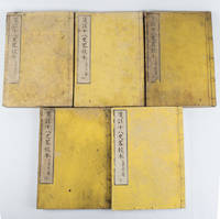
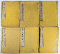
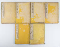
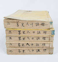
1880165397大阪.Osaka.: 中川勘助.Nakagawa Kansuke. 明治131880. 5 volumes of 7. Missing volumes two and three bound in Japanese 5 hole stab binding double leaves oriental style. Paper title labels laid down upper covers rubbed with loss soiling and creasing on covers edges little soiled occasional worming still text clean and sound. Text in Chinese with Japanese reading marks. 26 x 18.5cm. A Japanese edition of Jūhasshiryaku 十八史略 Shi ba shi lue in pinyin with extra notes. The text was checked against the authorative text by Japanese scholar 近藤元粹 Kondō Gensui. The Summary of the Eighteen Histories is an introductory Chinese history for children compiled by Zeng Xianzhi 曾先之 in the Yuan period. The full set is complete in 7 volumes. . 中川勘助.[Nakagawa Kansuke]. unknown
1880165396大阪.Osaka.: 中川勘助.Nakagawa Kansuke. 明治131880. 6 volumes of 7. Lacks volume 1 bound in Japanese 5 hole stab binding double leaves oriental style. Paper title labels laid down upper covers soiling and creasing on covers edges little soiled occasional worming and chops insect damage upper edge volume one still text clean and sound. Text in Chinese with Japanese reading marks. 26 x 18.5cm. A Japanese edition of Jūhasshiryaku 十八史略 Shi ba shi lue in pinyin with extra notes. The text was checked against the authorative text by Japanese scholar 近藤元粹 Kondō Gensui. The Summary of the Eighteen Histories is an introductory Chinese history for children compiled by Zeng Xianzhi 曾先之 in the Yuan period. The full set is complete in 7 volumes. . 中川勘助.[Nakagawa Kansuke]. unknown
1880165395大阪.Osaka.: 中川勘助.Nakagawa Kansuke. 明治131880. 6 volumes of 7. Lacks volume one bound in Japanese 5 hole stab binding double leaves oriental style. Paper title labels laid down upper covers soiling and creasing on covers edges little soiled ink annotation upper edge some volumes string split volume seven with some browning still text clean and sound. Text in Chinese with Japanese reading marks. 26 x 18.5cm. A Japanese edition of Jūhasshiryaku 十八史略 Shi ba shi lue in pinyin with extra notes. The text was checked against the authorative text by the Japanese scholar 近藤元粹 Kondō Gensui. The Summary of the Eighteen Histories is an introductory Chinese history for children compiled by Zeng Xianzhi 曾先之 in the Yuan period. The full set is complete in 7 volumes. . 中川勘助.[Nakagawa Kansuke]. unknown
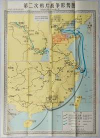
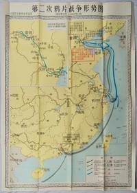
1980216471Shanghai.: 地图出版社.Map Press. First Edition. 1980. Colourful folding teaching reference wall map of China during the Second Opium War October 1956 - November 1860. Includes an inset at top left of the route that French and British invaders took in 1860 and a key at bottom right explaining the dates of different invasion routes. Text boxes explain key events. Original wrapper creased on top edge with a red "山东济南第五十." stamp. Bottom right corner of map very slightly worn else in excellent bright crisp condition. 106 x 76cm. Text in simplified Chinese characters. . 地图出版社.[Map Press]. unknown
1980216702Shanghai.: 地图出版社.Map Press. First Edition. 1980. Colourful folding educational wall map of China during the Second Opium War October 1956 - November 1860. Includes an inset at top left of the route that French and British invaders took in 1860 and a key at bottom right explains the dates of different invasion routes. Text boxes explain key events. Original wrapper repaired with cellotape and washi paper. Bottom right corner of map very slightly worn else in excellent bright crisp condition. 106 x 76cm. Text in simplified Chinese characters. . 地图出版社.[Map Press]. unknown
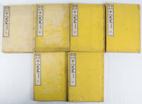
1878165197Tokyo.: 山中市兵衛.Yamanaka Ichibee. 1878. Volumes 2 3 5-7 of 7 volumes a Japanese edition of 18 Chinese histories classics spanning from pre-Qing to Song Dynasty. Originally edited by a Chinese scholar 曽先之 Zeng Xianzhi in Yuan Dynasty it was later annotated by another Chinese scholar 陳殷 Chen Yin in Ming Dynasty. This is Japanese edition compiled by 大賀富二 Ōga Tomoji has Japanese reading marks. Four-hole stab binding double leaves oriental style paper title label missing on volume 2 some marking covers particularly volumes 2 and 3 occasional worming string volume 3 split but still holding in good condition. 18.4 x 12.7cm. . [山中市兵衛?].[Yamanaka Ichibee?]. unknown
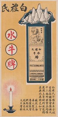
1519219406Shanghai.: No publication details. Circa 1915 -1930s. Coloured handbill advertising Price's Water Buffalo Brand candles. Text in traditional Chinese characters 26.2 x 13.2cm. Very good. Price's candles started developing internationally in 1910 and in 1915 had a factory in Shanghai. In this advertisement the name of this old family brand founded in 1830 Price's Candles has been rendered into Chinese with characters that sound like Price's i.e. 'Bai li shi' 'bai li' being a name which would appeal in China being a homonym for 'a hundred benefits'. It is also a homonym for 'white pears' which the advertisement has included as a clever visual pun - white pears in fact not pears but the top portion of six candles in a box. <br> <br>According to the text these 'foreign' candles have won international prizes are made of top quality ingredients and have a number of special qualities; they are produced by the Chinese in Shanghai under expert supervision last for a long time do not have an unpleasant smell and will not go soft and bend. The picture includes an image of strength - an old man holding burning candles riding a water buffalo drawn in an appealing Chinese line-drawing style with the characters for happiness good fortune and long life next to him guaranteed to appeal to Chinese customers. . No publication details. unknown
19886061988 - broché - Peking University Press - 1988 - In-12 (18 x 11 cm) broché, couverture à rabats - 241 pages - Illustrations et photographies en noir et blanc - Quelques cartes dépliantes - ISBN : 7-301-00453-2 - Traduction de Wang Mingzhu & Meg Gallagher - Textes en anglais et en chinois - ENGLISH: Peking University Press - 1988 - In-12 (18 × 11 cm) softcover with flaps - 241 pages - Black-and-white illustrations and photographs - Includes some fold-out maps - ISBN: 7-301-00453-2 - Translated by Wang Mingzhu & Meg Gallagher - Texts in English and Chinese - 中文:北京大学出版社 — 1988年 — 12开(18 × 11厘米)平装折口封面 — 241页 — 黑白插图及照片 — 附若干折叠地图 — ISBN 7-301-00453-2 — 译者:王明珠、Meg Gallagher — 中英文对照
1934159936No publication details. circa1934. Complete Part Three of the "General History of Qing Dynasty" 清代通史 in 2 volumes by the modern Chinese historian Xiao Yishan 1902-1978. This work is made up of 10 chapters which focuses on the Boxer Rebellion and Chinese Qing government's politics and foreign affairs. Volume I: 38 124 228 280pp. Volume II: 497 130pp. Rebound in modern cloth boards titled in gilt on the spine. Upper wrapper with title and list of contents of both volumes laid down with some loss not affecting the text 8 pages of volume 2 p.123-130are also laid down. Title of volume one gives the incorrect information of the volume number whereas on the spine the correct volume number is shown. Browned throughout with occasional tears and minor loss. A stamp in the set which says "Complete set two volumes cost four Dayang " silver coins which were in use as Chinese currency suggests the books were published and sold during Chinese Minguo period 1911-1949. Text in traditional Chinese. "General History of the Qing Dynasty" was written and published over almost a decade from 1923 to 1930. The first part was first published in 1923 while Xiao Yishan 1902-1978 was still a student at Peking University. <br> <br>This two volume set is the third part of the series and is Xiao's lecture notes from the period he was lecturing at Peking Political College of Culture and History 北平文史政治學院 between 1928 and 1930. He was the founder and principal of the college. Volume one lists very detailed information on the Qing imperial officials both local and central governments and also presents famous Qing scholars' origin and major works. Volume two focuses on the rising and falling of Taiping Rebellion movement in China and also covers the political history under the reign of Tongzhi Emperor 1861-1875 . No publication details. hardcover
2004111603Beijing, China Photographic Publishing House 2004 In-4 à l’italienne 23 x 30,5 cm. Cartonnage éditeur beige et argent sous coffret à l’identique, tranches argentées, 191 pp., entièrement illustré de photographies en couleurs, sommaire. Exemplaire à l’état neuf.
1818165209京都.Kyoto.: 五車楼.Gosharō. 明治18 1885. 6 volumes of 7 volume-set missing volume one bound in Japanese 5 hole stab binding woodblock printed on double leaves oriental style. Paper title labels laid down on yellow embossed upper covers some rubbing and light soiling in good condition. Text in Chinese with Japanese reading marks. 26 x 18.5cm. A Japanese Meiji edition of Jūhasshiryaku 十八史略 Shibashilue in pinyin with extra notes added by a Kyoto resident 奧野精一 Okuno Seiichi. The Summary of the Eighteen Histories is an introductory Chinese history for children compiled by Zeng Xianzhi 曾先之 in the Yuan period. Complete in 7 volumes. . 五車楼.[Gosharō]. unknown
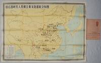
1981216685Shanghai.: 地图出版社. Map Publishing House. Reprint. 1981. Edited by 中国历史博物馆 Zhongguo lishi bowuguan. Folding educational history wall chart of important locations in early middle and late human fossil and Stone Age cultural sites in China. Inset map of all the islands claimed by China in South China Sea bottom right. Key at bottom left. Margins slightly browned as is one panel on reverse though map image unaffected. In very good crisp condition with decorative wrapper slightly chipped lower left corner. 75 x 106cm text in simplified Chinese characters. . 地图出版社. [Map Publishing House]. unknown
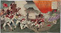
1894218366Yokoyama.: Ryōhachi . 1894. Conjoined triptych of ink and watercolour woodblock prints trimmed to the margins together 35 x 63.3 cms backed onto Japanese scrap paper with some writing title and descriptive cartouches top right red censor's stamp lower left and artist's signature lower right some paper abrasions wear at the joins slight bleeding of ink and offsetting on the verso but overall in good condition. Vivid depiction of the Battle of Seonghwan also known as the battle of Asan in Korea July 29 1894 the first major land battle on of the Sino-Japanese War 1894-1895. Chinese troops are seen fleeing the charging Japanese marines and the silhouettes of airborn casualties are depicted in the bright orange explosion. <br> <br>Yōsai Nobukazu 1872-1944 was active towards the very end of the ukiyo-e period when the popular days of this style were over. Printmakers like Yōsai struggled and he survived as an artist by depicting the Sino-Japanese and Russo-Japanese wars. Yōshū Chikanobu was his teacher active 1838-1912 and Yōsai Nobukazu was considered his best student. The majority of his prints were triptychs of battles of the Sino-Japanese war. See a digitisation of this woodblock from the Lavenberg Collection of Japanese prints online at the University of Oregon The caption on top right praises the Japanese troops' bravery against 500 strong Chinese troops. <br> <br>From the collection of the late John Caiger lecturer in Asian studies ANU. . Ryōhachi (?) unknown
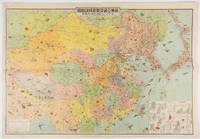
1419214497東京. Tokyo.: 東京日日新聞社. Tōkyō Nichinichi Shinbunsha. Showa 14 1939. Colour folding illustrated map charts black and white photographic illustrations with interpretive text on reverse. Few very small tears at margins some light creasing but overall still a good attractive map. 55 x 79cm. The map of China and surrounding areas are richly illustrated with little images showing the resources and products of the countries of East Asia together with their road railway sea and air routes which are marked in detail. Inset charts show Chinese trade figures in detail. The reverse side of the map provides summary information on China each region Manchukuo and Outer Mongolia with black and white photographic illustrations. Chinese trade and resource graphs are printed on the corner of the map and include steel petroleum rice pigments and dyes wood products etc; comprehensive information on population Chinese governments and Western investments are included in the reverse side. <br> <br>The map was a supplement of Volume 3 Number 1 issue of the Tonichi Jikyoku Joho Tokyo Nichinichi Shinbun Current Affair and Information in January 1939 which later became Mainichi Jikyoku Joho. The map and detailed information demonstrate the deep interest Japan had in China and its resources at this time reflecting its territorial desires. . 東京日日新聞社. [Tōkyō Nichinichi Shinbunsha]. unknown
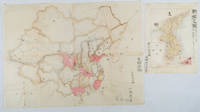
1902220266Japan. No date. Circa1902. Two very attractive colour folded manuscript maps one showing China and the other Korea. <br> <br>Map of China: Watercolour map 48 x 63.5cm. Closed tear now professionally repaired. <br> <br>Map of Korea: Finely detailed watercolour map a few tiny holes very neatly repaired on the verso with archival washi. 33 x 24.5cm Two delicate hand-painted maps one of China and one of Korea produced by a Japanese student cartographer named Koike Tokushige 小池徳重. <br> <br>The undated map of China appears to have been produced in the first five years of the twentieth century: a time when Japan had recently colonized Taiwan and when Japanese economic and political interest in the region was rapidly expanding. The inscription on the map suggests that it was a third year college project. But the high level of detail suggests that the artist had considerable experience of map making. The map of China shows the main provinces rivers major transport routes the Great Wall and the location of key cities although the names of the cities are not included. It also shows outlines of the Korean Peninsula Taiwan and the Japanese island of Kyushu but not the rest of Japan. <br> <br>The map of Korea is more detailed. It provides an accurate outline of the Korean Peninsula with careful hatching indicating changes in elevation. Rivers and major road routes are shown on the map and the locations of major towns are marked though only Busan and Incheon are named. Dotted lines show coastal sea routes and routes between Kyushu and Busan and between Incheon and China. The map shows the Gyeongin railway line between Seoul and Incheon which was completed in 1899 and route of the Gyeongbu railway line between Busan and Seoul whose construction started from both ends in 1901. But the map depicts only small sections of this line close to Seoul and Busan as being completed with the rest more lightly outlined to show the projected route implying that the map was drawn around 1901-1902 and certainly before the Gyongbu line was opened in 1904. <br> <br>Inserted text gives the land area and population of Korea. Rather strangely though the figure given for the Korean population is vastly underestimated. Ikeda gives this as 5.7 million when in fact at that time is was around 18 million. . unknown
1905217437Guangdong.: 廣東省香山縣梅溪鄉陳門容氏敬刊. 1905. Buddhist philosophical text ii 53 folded pages woodblock print from the Guangxu era. Browned throughout upper corners worn with loss some washi repairs original wrappers worn and torn with considerable loss to upper cover. Upper wrapper torn with loss however title page and Chinese four-hole stab binding is intact. Slight bleeding of wrapper colour onto the first few pages only. Text complete. 21.8 x 13.2cm. . 廣東省香山縣梅溪鄉陳門容氏敬刊. unknown
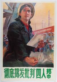
1977215861Beijing.: 人民美术出版社. People's Fine Arts Publishing House. 1977. Large anti-Gang of Four propaganda poster featuring a heroic young female worker in an industrial setting. Some lightly browned holes along upper edge of poster. In very good condition colours fresh and bright. 77 x 53cm. Poster was designed by Sun Quan 孙荃 who was assigned to the People's Fine Arts Publishing House in 1973. The background banner calls for people to swear to struggle together to the end against the anti-Party group of Wang Zhang Jiang and Yao. . 人民美术出版社. People's Fine Arts Publishing House. unknown
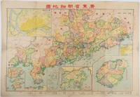
1936216107Qi 昌亞新地學社. Minguo 25 1936. A very attractive colour folding map of Guangdong province including inset maps of Guangzhou Shantou the European concessions of Hong Kong and Macau as well as Hainan the Paracel Islands and South China Sea. Scale of 1:1300000. Divided into eight panels measuring 54.5 x 79cm. Little light browning tide mark left margin barely intruding into printed image few tiny chips at extremities mended on reverse with washi in few places though overall in very good condition. A curious and colourful map of Guangdong issued towards the end of the Nanjing decade detailing the province's local political divisions its infrastructure such as roads railways and telegraph lines as well as its topography through stylised mountain ranges ridges and passes. <br> <br>Inset maps of Hong Kong and Macau noted as foreign concessions alongside maps of the South China Sea and Paracel Islands ostensibly affirms the status of these territories as rightful components of Guangdong in the view of the Kuomintang Government. . [Qi?] 昌亞新地學社. unknown
19956771995 - broché - Éditions des Beaux-Arts du Hebei et Académie Centrale des Beaux-Arts de Chine - Collection « Art du croquis et enseignement » - Deuxième tirage : 1995 - In-4 (28,5 x 21 cm) broché, couverture à rabats et plats cartonnés - 60 pages - Très nombreuses illustrations en noir et blanc - ISBN : 7-5310-0578-6 - Ouvrage en chinois - ENGLISH: Hebei Fine Arts Publishing House and Central Academy of Fine Arts - Make the Best of a Mistake: Wang Huaxiang's Sketch Art - "Sketch Art and Teaching" Series - Second printing: 1995 - Quarto (28.5 × 21 cm), paperback with flaps and stiff card covers - 60 pages - Very numerous black-and-white illustrations - ISBN: 7-5310-0578-6 - Text in Chinese - 中文:河北美术出版社、中央美术学院出版 - 《素描艺术与教学》丛书 - 《将错就错:王华祥的素描艺术》 - 1995年第二次印刷 - 16开(28.5 × 21厘米)平装,带折页封面及硬纸板书面 - 60页 - 大量黑白插图 - ISBN 7-5310-0578-6 - 中文版