Corea, ChickBiblio.com
Photo signed
256655Fine. Photograph of Chick Corea the American jazz musician b. 1941 ca. 1965 sitting at a keyboard. <br/><br/> unknown

The Old Mill Bookshop · États-Unis100,00 $US≈ 84,61 €
725 résultats
19942091502135418192Byakutei-sha 1994. Soft Cover. Fine. Number of books: 1 Byakutei-sha paperback
97032001Seoul 1966 USOM-USIS. Color boards many color & b.w. photos indexed-tabs a guide for American diplomatic corps. stationd in Korea. This work was prepared under the guidance of Ambassador W.G. Brown has tab index guides: Part I: Orientation. Part II: Life at Post. Part III: Country Regulations & Post Admin. Part IV: Special Guidance. With many maps some folding drawings & graphics. A useful guide to the peoplel customs traditions of the Koreans. "This official post report prep- ared at the post. Any other information you recieve cover- ing the facts as set forth is to regarded as unofficial in- formation. unknown
20032091502133903457Ewha Culture Company 2003. Soft Cover. Fine. Volume: 1 Ewha Culture Company paperback
a103174Seoul. 1967 first edition. Koreana Quarterly vol 9 no. 2. large octavo wraps. 158p. Articles include: Development of Party Politics in Korea by Lee Joung-sik; Political Parties and Factionalism in Korea by Ko Yong-bok; Statistical Analysis of Elections in Korea by Kim Kyu-taik; Korean Press and National Elections by Choe Suk-chae. Good Text toned but legible and not brittle; no owner marks. . paperback
68113Seoul Pictorial Korea 1954. kartoniert; flexibler grüner goldgeprägter Einband mit farbig illustriertem Schutzumschlag / Anz. Seiten: 199 / 19 x 26 cm / mit zahlreichen mehrheitlich schwarzweissen Abbildungen auf Tafeln und im Text; Karte auf hinterem Vorsatz / Zustand: gut mässige Gebrauchsspuren; Einband leicht berieben und etwas gebräunt Papier und Vorsätze leicht gebräunt Etikettenrückstand auf vorderem Vorsatz Schutzumschlag berieben gebräunt und randlädiert Besitzerstempel auf Vorsatz Beigelegt 1 Zeitungsartikel Seoul, Pictorial Korea, 1954 unknown
68114Seoul Pictorial Korea 1955. kartoniert; flexibler blauer goldgeprägter Einband mit farbig illustriertem Schutzumschlag / Anz. Seiten: 192 / 19 x 26 cm / mit zahlreichen mehrheitlich schwarzweissen Abbildungen auf Tafeln und im Text; Karten auf den Vorsätzen / Zustand: gut mässige Gebrauchsspuren; Buchblock angeplatzt Einband leicht berieben und etwas gebräunt 3 Ecken leicht bestossen Papier und Vorsätze etwas gebräunt Schutzumschlag berieben leicht gebräunt und mässig randlädiert Widmung auf Vorsatz Etikettenrückstand auf vorderem Vorsatz Seoul, Pictorial Korea, 1955 unknown
256655Fine. Photograph of Chick Corea the American jazz musician b. 1941 ca. 1965 sitting at a keyboard. <br/><br/> unknown
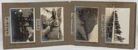
1923220274Taisho 12 1923. Over fifty black and white photographs annotated laid down in concertina style cloth covered photograph album 18 x 26.5cm most photographs measure 9.3 x 13.5cm nine measure 10 x 7cm. Some silvering of photographs but most are in very good condition. A fascinating concertina-folded album of high-quality photos dating from 1923 and showing Japanese military training exercises in northeastern Korea as well as scenes of everyday life in the surrounding region including the Ranam Cheongjin Hoeryong and Gando areas. Many of the photos appear to have been produced by a professional photographer but acquired by the soldier who has created this album who has added his own annotations based on personal experience. <br> <br>The first photo shows an inset portrait of a soldier named Takuuchi next to the flag of the Japanese Imperial Army's 75th Infantry Division. This is followed by a series of photos of Japanese colonial buildings in Korea including the military base of the 75th Infantry Base an overview of the city of Hoeryong on which the owner has placed a cross in ink marking the location of the recently contructed Hoeryong Shinto Shrine Heoryong's hospital and railway station and a street in the city centre an overview of Cheongjin and a panoramic overview of Ranam City also with the Ranam Shinto Shrine marked with a cross. The attention paid to these shrines which were crucial symbols of Japanese colonial rule emphasises the album creator's nationalist sentiment. There are two images of the landscape of the Tuman River and a photo of sacks of soy beans being unloaded in Gando. Other photos show scenes of everyday life including women washing clothes and grinding grain and two photos of a Korean wedding ceremony. A few of these photos including one of a village of thatched-roofed houses are in a smaller format than the images in the rest of the album and may have been taken by the album's owner himself. Twenty of the photos show 1923 training exercises conducted by the 75th Infantry Division in the Ranam area. These have also been annotated with the album owner's comments providing extra information about the content of the photos. The album concludes with two striking images of thick ice on a river probably the Tuman and of the Hoeryong Shinto Shrine in late evening. . hardcover
191744452London: Thos. Cook & Son 1917. 8vo. 181 xxiii pp. 3 large folding maps numerous maps numerous photo illusts. Green cloth blk lettrng & insignia on frnt cvr blk lettrng on spine mnr rubbng edgewear still a VG copy. Third edition revised & expanded of this excellent Cook travel guide for travel through China Manchuria and Korea during World War I. There are detailed sightseeing instructions for Peking visiting the Great Wall Tientsin Tianjin Port Arthur in Manchuria and more. Of particular interest is the extensive section on Chosen Korea nice folding map of Seoul photo illustrations etc. Thos. Cook & Son, hardcover
0364444215.Gpaperback. Good. Access codes and supplements are not guaranteed with used items. May be an ex-library book. paperback
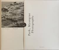
2019234535Daegu South Korea: Martianstory - Wall Press 2019. Brossura custodia wrappers slip-case. Ottimo Fine. Belle fotografie in bianco e nero riprodotte a piena e doppia pagina di Park Myungrae. Cm 44x31. pp. 64. Ottimo Fine. Prima edizione di 1000 esemplari First edition of 1000 copies. Martianstory - Wall Press, unknown
19612092902140301542Hayakawashobo 1961. Soft Cover. Fine. Number of books: 1 Hayakawashobo paperback
38009901Korea late 18th-early 19th century 1780-1810. Eight color gouache pastel tinted maps ca. 57.5 x 90.1 cm.contemporary re-backing very solid clean examples complete set of all provinces hand-painted gouache manuscripts. RARE & OBSCURE . . . . A RARE & COMPLETE SET OF ANTIQUARIAN MANUSCRIPT KOREAN . . . YI PERIOD PROVINCIAL MAPS . . "P'ALTO CHIDO" OR "EIGHT PROVINCES MAPS" . . . DELUXE ELEPHANT FOLIO SIZE SHEETS . . . HAND-COLORED GOUACHE PASTELS . This is a very RARE & COMPLETE set of eight Korean provincial manuscript maps. Drawn circa 1780-1810 by an unsigned Korean cartographer. These maps are of historical importance giving place names isolating the time frame. . Painted on very thin finely hand-made mulberry-fiber tissue paper contemporary re-backed with a stiff hand-made paper. Beautifully hand-painted & colored in gouache pastels. . The record shows several reliable verities of manuscript maps showing the eight ancient Korean provinces. . Commonly these maps had no title cartographer's name date or other critical bibliographic colophon data. This is a common theme with Korean manuscript maps. . Political divisions of Korea are by and large mostly stable making name comparisons easier. . PROBABLE MAP TITLES INCLUDE: . a. The "SINJUNG-TONGGUK-YOJI-SUNGNAM:" "EIGHT SEPARATE MAPS EACH SHOWING ONE COMPLETE PROVINCE OF THE EIGHT KOREAN PROVINCES similar in intention to the "P'ALTO CHIDO." . The eight provinces were established during the Chosen dynasty 1392-1910 alternately and commonly called the Yi dynasty. . The eight provinces are from the north to south: . 1. Hamgyong 2. P'yong'an 3. P'yongyang 4. Kangwon 5. Hwanghae 6. Kanghwa 7. Kyongsang 8. Cholla'ungch'ong . During the Sejo reign 1455-68 Yang Songji made the first "P'Alt-do "P'ALTO CHIDO" type maps of the eight provinces this type and style became the "standard" for future examples. There after his style and format were copied by others for centuries. . b. A second version and style of the above eight provinces maps is called "TONGGUK CHIDO: MAP OF THE EASTERN COUNTRY i.e. KOREA" showing a compressed northern frontier along Manchuria the characteristic "CHONG CH'OK" style. . c. A third similar map: "P'ALDO-CHONGDO: A SINGLE MAP SHOWING THE EIGHT PROVINCES OF KOREA." . These maps are pictorially beautiful and artistically drawn in detail. Graphics expressing a primitive naive folk charm depicts prominent geological landscape features. Mountain ranges hills forests in green streams/rivers blues political district seats distinctively painted cartouches box-like in various differing colors for each province. Roads paddy coastal shore line & islands in blue tints with other features nicely colored. . There are a large number of name throughout each map all written in Hanzi traditional Chinese characters called "Hanja" in Korean as was the common practice at that time for Koreans. There are no Hangul characters at all. The Hanja identify navigational directions names of surrounding ocean harbors beaches geographical names city towns villages mountains rivers roads and the like. . Each of the eight maps illustrates a complete single province. Within each of the various political divisions and boundaries outlined and named. . RARITY OF KOREAN ANTIQUITIES: Antiquarian Korean examples are sparse when compared to items of the same period in China and Japan. Korean works are less than 10% of those created elsewhere. . Fewer Korean items were made survived and preserved. The attrition rate: bad weather unstable ancient mud building structures fires natural disasters earthquakes war and other factors diminished the remaining examples. . Those the numbers that come to marked are steadily reduced while the value continues to appreciate. Many never return to market when acquired by institutions or private collectors who eventually donate to museums. . DATING THESE MAPS: These were mostly undated. . There are three possible methods of dating. . a. BY PLACE NAME: there are details in the reference books about county seat names being colored or put in various kinds of 'boxes' on the map depending on that according to the resources approximate dates can be derived. . b. PAPER TECHNOLOGY & FIBERS: Koreans have been using hand-made mulberry bark and fiber paper from the Zhenguan period AD 627-649 printing Buddhist sutras by woodblocks on similar kinds of paper. . These two technologies papermaking and woodblock printing was transmitted to Japan around 700 AD. . Since that time both Koreans & Japanese have utilized mulberry paper Washi in Japanese to woodblock print and paint a large variety of items including maps books and single page works. . By comparing the paper of these maps with known dated printed Japanese books a very close approximate date can be derived. . These Korean map papers are nearly identical to dated woodblock-printed Japanese examples we have. It is therefore highly possible these maps were painted on hand-made mulberry paper from circa 1780-1810 period. . In ancient times sheet size was limited to a small size then joined to other sheets to create a large size single sheet. These maps are of that format. See McCune below where he states the kind of paper used which matches our examples. . CONDITION: Per McCune we summarize: as usual these maps were folded several times from their creation time so they could be safely stored and carried in small 'book' format in covers with a tied string. See McCune below. . Being painted on very fine & thin hand-made mulberry paper most all examples were eventually re-backed. Ours as typical have period re-backing using the same character hand-made mulberry fiber paper of a thicker quality. . They are well preserved however nevertheless as usual there remains some old original wear at the folds the expected light water stains dustiness with other typical very minor flaws for an item of this grand size being 200 years old. These do not detract from the overall excellent impression and stunning appeal. . RARITY: . The complete set is RARE! The work is nicely executed in a firm hand with artistic value illustrating artistically hills mountains and other features of the map pictorially. It is not only a map but a work of art. Tastefully colored in subtle pastels nice representation of water rives and sea. . Such early and beautifully artistic examples seldom come to market. . A RARE AND FRESH EXAMPLE NEVER BEEN ON THE MARKET IN THE LAST 120 YEARS ! . PROVENANCE: These items were acquired from a former missionary's estate who was stationed in Korea from circa 1900-1930's. They have been in this private collection since and have never been on the market. . Color scans are posted to our website. . REFERENCES: . TOOLEY Ronald V. et al.: Article: Shannon McCune: SOME KOREAN MAPS pp.70-102 with illustrations. McCUNE Shannon.: KOREAN MAPS OF THE YI DYNASTY KOREAN CULTURE Korean Consulate General L.A. Ca. Sept. 1983 pp.21-31 34 back cover color plate color & b.w. illustrated. . He discusses "P'ALTO CHIDO""EIGHT PROVINCES MAP" origins maps without scale and were copies of a Korean scholar named Won his title was: Haksaeng works based on Chong Ch'ok's 1390-1475 TONGGUK CHIDO MAP OF THE EASTERN COUNTRY then modified by Won to be the more typical "P'ALTO CHIDO" "EIGHT PROVINCES MAP" but in his new style. This new style clearly resembles our maps in layout format color of county seats and similar boxes around them and other critical details. KOREAN CONSUL GENERAL KOREAN CULTURE September 1983 pp.21-31 34 color map on back cover color and b.w. illustrated. . It was from these maps that the later versions similar to ours eventually emerged mostly by Imperial Order by the ".Yi Dynasty court specifically decreed that both magistrates and governors should prepare up-to-date maps of their territories udder their supervision." p.25. HARLEY J.B. ed. et al.: CARTOGRAPHY IN THE TRADITIONAL EAST AND SOUTHEAST ASIAN SOCIETIES. Ahead of Title: THE HISTORY OF CARTOGRAPHY Vol. 2 Book 2 an excellent article by Gari Ledyard: CARTOGRAPHY IN KOREA pp. 235-345239 figures 10.23 10.24 et al. NAKAMURA Hiroshi.: EAST ASIA IN OLD MAPS. . --. NIHON KO CHIZU TAISEI: GREAT COLLECTION OF OLD JAPANESE MAPS MONUMENTA CARTOGRAPHICA JAPONICA . --. OLD CHINESE WORLD MAPS PRESERVED BY THE KOREANS. Article in IMAGO MUNDI IV 1958. LEE Chan. CH'AN Yi.: OLD MAPS OF KOREA. Han'guk ko chido. By: Ch'an Yi Hong-gyu Che Han'guk Tosogwanhak Yon'guhoe. He discusses and illustrates a good number of similar examples. On pp.226-27 he outlines an early Yi Dynasty example of: THE MAP OF EIGHT provinces found in TONGGUK YOJI SUNGNAM Chong Sang-gi's Tongguk Chido. These manuscripts were on large paper one province per sheet. Many other fine related examples are illustrated & discussed. . --. OLD MAPS OF KOREA: HISTORICAL SKETCH. He traces the early origins of Early Yi dynasty1392-1910 Eight Provinces Map origins and progressions excellent lucid article with illustrations and references to Yi HOE's MAP OF EIGHT PROVINCES. Excellent essay on provincial maps. SHIN Michael D. ed.: KOREAN HISTORY IN MAPS: From Prehistory to the Twenty-First Century. British Museum similar examples cited: commons-wikimedia-org/wiki/Category:Room_67_British_Museum# /media/File:Map_of_the_Jeolla_Province_British_Library_c.27. f.14_fol.12_n02.jpg Library of Congress: Young Il Kim: dong-kookyu-do: A RECENTLY DISCOVERED MANUSCRIPT OF A MAP OF KOREA. Imago Mundi vol.21 1967 pp.31-49 illustrated. . . unknown
19952080502106404145Liquor Distribution Revitalization Study Group 1995. Soft Cover. Fine. Number of pages: 382p Liquor Distribution Revitalization Study Group paperback
19952080502106603865Liquor Distribution Revitalization Study Group published by Goma Shobo published by 1995. Soft Cover. Fine. Volume: 1 Liquor Distribution Revitalization Study Group, published by Goma Shobo, published by paperback
19952090202120809797Liquor Distribution Revitalization Study Group 1995. Soft Cover. Fine. Volume: 1 Liquor Distribution Revitalization Study Group paperback
19952091502135421065Liquor Distribution Revitalization Study Group Goma Shobo Publishing 1995. Soft Cover. Fine. Number of books: 1 Liquor Distribution Revitalization Study Group Goma Shobo Publishing paperback
19952092902141503638Gomashobo 1995. Soft Cover. Fine. Size: A5 size Gomashobo paperback
19952092902144201875Gomashobo 1995. Soft Cover. Fine. The book is in fine condition. Gomashobo paperback
19372091502135500295Not Available 1937. Soft Cover. Fine. Number of pages: 30 pages Booklet Not Available paperback
1985145179Los Angeles: CBS / Universal City Studios 1985. Draft script for the 1986 pilot episode for the television show "Outlaws." <br /> <br /> A sheriff and his deputies are transported from the year 1899 into the future by a lightning storm and they establish a new life as private detectives. <br /> <br /> Set in Houston in 1899 and 1999. <br /> <br /> Gray titled wrappers. Title page present noted as production No. 86084 dated November 26 1985 with credits for screenwriter/executive producer Nicholas Corea. 123 leaves with last page of text numbered 120. Xerographic duplication rectos only. Pages Fine wrapper Fine bound with three gold brads. CBS / Universal City Studios unknown
32019501Leipzig 1912 Velhagen & Klasing. Single sheet color map 28 x 44 cm. from "Andree's Allgemeiner Handatlas" very clean bright copy German text. A very good map of Eastern Asia shows all of Korea Quelepart Island lower tip of Japan Formosa Inner Mongolia Manchuria Chili Shantung Honan Kiangsu down to Taiwan along the East coast of China Shanghai down to Hong Kong and Kwangtung Guandong Province shows all of the Ryukyu Islands. Nicely done good color. . unknown
1873168911873. Original Map Asia: China Korea Thailand India Taiwan Malaisia Kuwait Arabia 1873 With The Title "Asia" in the left corner. Origin of the Map is from the "Stieler's Hand-Atlas." continent-based upon von Stulpnagel published in Gotha by Justus Perthes. Germany. Beautifully Hand Colored. Date of issue: 1873. Size: The sheet measures aprox 18 in x 15 in or 45 x 37 cm. Overall very good condition. unknown
19982091502135417239Not Available 1998. Soft Cover. Fine. Number of books: 1 Not Available paperback
19612091502135419031Not Available 1961. Soft Cover. Fine. Number of books: 1 Not Available paperback