55 résultats
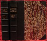
1733E05532 volumes. 8xxiv616471 pages with 4 maps ad view one folding and 3 plates one folding; 2693892 pages with 1 map and 6 plates. Quarto 10 1/4" x 10 1/4" bound in half leather with raised spine bands and gilt lettering to spine over marbled boards. Borba de Moraes page I:453; European Americana 733/146; Sabin 38591 First edition.<br /><br />Joseph-François Lafitau was a French Jesuit missionary ethnologist and naturalist. He is best known for his use of the comparative method in the field of scientific anthropology the discovery of ginseng and his writings on the Iroquois. Lafitau was the first of the Jesuit missionaries in Canada to have a scientific point of view. Lafitau is considered the first of the modern ethnographers and a precursor of scientific ethnology for his work on the Iroquois. He developed a model of studying peoples that involved describing existing cultures on their own terms—not in comparison to European society. He distinguished generic and specific traits transforming the "generic savage" into specific tribal groups. He explained that "only from specific identities can genetic relations be inferred."5 Furthermore he was the first to declare "contemporary primitive cultures throw light upon the culture of ancient people and vice versa. Lafitau is remembered for applying the comparative method with a greater level of competency than any of his contemporaries. Through original field observations he was able to critique the works of earlier writers on Primitive peoples. By using the Comparative Method Lafitau rejected all theories of social and cultural change and instead used his study to demonstrate the similarities in customs practices and usages of the Native North Americans with diverse peoples from different continents and centuries. He consistently relied on the doctrine of degeneration: all men originally shared one religion with one God but over time as people migrated to separate margins of the earth where they then lost touch with the values and traditions of this one true religion and culture. Therefore Lafitau believed in the "psychic unity of mankind" and the doctrine of primitive monotheism. His major work written in French was first published in 1724 in Paris. It is entitled <i>Customs of the American Indians Compared with the Customs of Primitive Times</i> <i>Moeurs des Sauvages Amériquains Comparées aux Moeurs des Premiers Temps</i> and is 1100 pages in total. In 1974 William Fenton and Elizabeth Moore made the first translation into English available. Lafitau published two other works. One <i>Histoire de Jean de Brienne Roy de Jérusalem et Empereur de Constantinople</i> Paris 1727 was released before he returned to Canada; it is little known and seldom seen. A two-volume <i>Histoire des découvertes et conquestes des Portugais dons le Nouveau Monde . . .</i> 1733 appeared after he came home to France. Frequently found in libraries it is not just a compilation of original sources but an attempt to make available to French readers a story of exploration and adventure otherwise denied to them; in the chronicles he sees a long development of customs hitherto unnoticed such as he had reported in the <i>Mœurs</i>; from them understood only he says in the original languages of the people who practice them he builds his "system" or philosophy of history and once more he is concerned too with the relation between custom and natural history or ecology.<br /><br /><b>Condition:</b><br /><br />Beautifully rebound in half leather. Faint dampening to second volume; early owner's signatures on title pages inked stamps of St Charles Borromeo Seminary on front paste-downs and first title page lacks frontispiece else a very good to fine set.<br /> Chez Saugrain pere, quai des Augustins, au coin de la rue Chez Saugrain pere, quai des Augustins, au coin de la rue Pavee, a la hardcover books
1790E00534 of 6 volumes. Volume 1: i-ix-372 pages with 23 plates including frontispiece plate of Cook and 4 folding maps; Volume II lacking; Volume 3: 793-1184 pages with 11 plates including frontispiece of Possession Bay and 5 fold out maps; Volume IV: 1185-1546 pages with 26 plates including frontispiece of Woman Child and Man of Van Diemen's Land and 6 folding maps; Volume V: 1547-1938 pages with 30 plates including frontispiece of A View of Huaheine and 8 folding maps; Volume VI lacking. Octavo 8 1/2" x 5 1/2" bound in original full leather with red labels to spine with gilt lettering. Abridged by George William Anderson. An earlier Large folio edition by Anderson was published earlier. This edition originally issued in 80 weekly parts and also called the Large octavo edition. M K Beddie: 39 First edition of the bound edition.<br /><br />Captain James Cook RN was a British explorer navigator and cartographer ultimately rising to the rank of Captain in the Royal Navy. Cook made detailed maps of Newfoundland prior to making three voyages to the Pacific Ocean during which he achieved the first European contact with the eastern coastline of Australia and the Hawaiian Islands as well as the first recorded circumnavigation of New Zealand. Cook joined the British merchant navy as a teenager and joined the Royal Navy in 1755. He saw action in the Seven Years' War and subsequently surveyed and mapped much of the entrance to the Saint Lawrence River during the siege of Quebec. This helped bring Cook to the attention of the Admiralty and Royal Society. This notice came at a crucial moment both in his personal career and in the direction of British overseas exploration and led to his commission in 1766 as commander of HM Bark Endeavour for the first of three Pacific voyages. Cook charted many areas and recorded several islands and coastlines on European maps for the first time. His achievements can be attributed to a combination of seamanship superior surveying and cartographic skills courage in exploring dangerous locations to confirm the facts for example dipping into the Antarctic Circle repeatedly and exploring around the Great Barrier Reef an ability to lead men in adverse conditions and boldness both with regard to the extent of his explorations and his willingness to exceed the instructions given to him by the Admiralty. Cook was killed in Hawaii in a fight with Hawaiians during his third exploratory voyage in the Pacific in 1779.<br /><br />Condition:<br /><br />Lacks volume II and VI. First signature of volume one loose inner hinges cracked some interior soiling spine ends and corners of leather rubbed some scuffing to leather else a good set. Printed for A Millar, W Law, and R Cater hardcover books
1717E01353559index pages 36 of 37 maps and copper cuts of the coasts harbor cities plants and other curiosities comprising: 14 plates 3 folding 22 maps charts or plans 14 folding. title page printed in red and black. Printed from the author's original plates inserted in the Paris edition. Lacks the frontispiece map. Royal octavo 9 3/4" x 7 3/4" bound in leather with raised spine bands and red label with gilt lettering. Postscript by Dr Edmund Halley and an account of the settlement commerce and riches of the Jesuits in Paraguay. Palau 94965 Sabin 25926 Nissen ZBI 1433 Hill p117 First English edition.<br /><br />Frézier was educated in Paris and served as lieutenant of infantry from 1702 til 1707 when he entered the engineer corps. In 1712 the government sent him to examine the condition of the Spanish colonies in America. After visiting the principal points in Peru Chili and Brazil he returned to Marseilles. He pointed out several mistakes in the "Relation" of Father Feuille and this led to a bitter controversy between the two travelers. Frézier introduced the large Chili strawberry into France. First published in France in 1714. The first edition into English is preferable to the French original "because it contains Halley's. postscript which corrects certain geographical errors made by Frézier" Hill. "The first part of this book gives an interesting account of the voyage from France around Cape Horn. The second part relates to the voyage along the coasts of Chile and Peru describing the chief towns and cities. Frézier a man of observation brought back information of considerable geographical and scientific value. Much data is included about the native inhabitants.<br /><br />Condition:<br /><br /> Rebacked with original spine label laid down; lacking frontispiece map and binder's leaf free endpapers renewed intermittent foxing else a very nice copy. Jonah Bowyer hardcover books
1747BOOKS005853<p>24548 pages with three folding engraved maps present southern part of South America; part of the Pacific Ocean and the track of the Centurion round the world. Octavo 8 1/4" x 5 1/2" bound in full leather with five raised spine bands with red label to spine in gilt lettering with decorative blind-stamped ruled edges. Compiled from papers and other materials of the Right Honourable George Lord Anson and published under his direction by Richard Walter M.A. Chaplain of his Majesty's Ship the Centurion in that expedition. Hill I pp 317-138. Third edition.<br /><br />"This is the official account of Anson's voyage. England at war with Spain in 1739 equipped eight ships under the command of George Anson to harass the Spaniards on the western coast of South America for the purpose of cutting off Spanish supplies of wealth from the Pacific area. Lord Anson who was a friend and patron of Benjamin Robins after returning from the voyage around the world in the Centurion appears to have entrusted to Robins for revision the account of the voyage which had been compiled from the journals by his chaplain Richard Walter. It is probable that Robins revised and edited the work wrote an introduction and added dissertations." Hill. Perhaps the most popular account of maritime adventure of the eighteenth century. Anson's account of harrying the Spanish of South America and the taking of the Manilla galleon with treasure with a contemporary value of $800000 and his circumnavigation has long enjoyed a distinguished place as a masterpiece in descriptive travel.<br /><br /><strong>Condition:</strong><br /><br />Some small closed tears at the edges of the maps. Rebound in tooled leather with raised bands. Over all a very good to fine copy.</p> John and Paul Knapton and Office of the Lord High Admiral hardcover
178927184Leiden: Etienne Luzac 1789. Small 4to. 8 1/2 x 6 1/4 inches. Woodcut arms of the Netherlands at the head of the first sheet. 4pp. With a 4pp. "Supplement aux Nouvelles Extraordinaires de Divers Endroits du Numero LXXV" inserted. Together 8pp. Unbound.<br/> <br/>Extremely rare broadsheet containing news of the Malaspina expedition: among the earliest printed records of Spain's greatest scientific voyage to the Pacific Ocean California and the Northwest Coast of America in the 18th century.<br/> <br/>The extract under the above heading continues: ". Les Corvettes de la Marine Royage la Découverte & l'Entreprenante commandées par Don Alexandre Malespina Capitaine de Frégate ont mìs à la voile de Cadix le 30 Juillet dernier. L'Expédition dont elles son chargées ayant pour objet les progrès des Sciences & de la Géographie elles ont été munies de tout ce qui est nécessaire pour faire un voyage autour du Monde; & outre des Oficiers d'une habilité reconnuë elles ont à bord des Astronomes des Naturalistes des Botanistes des Peintres de Perspective & de Botanique pourvus d'une Collection ample & précieuse d'Instruments de Mathématiques de Physique & Astronomie." Other news in the broadsheet concerns revolutionary events in France including a lengthy speech from Necker given at the National Assembly as well as news from Russia Stockholm the Hague and elsewhere. In 1789 Malaspina and Bustamente drew up plans for this scientific circumnavigation which was to rival Captain Cook the purposes being to chart the most remote regions of America and to observe the political state of America relative to Spain. Alexander Dalrymple assisted them with scientific instruments a brilliant team of scientists was assembled and ships specially constructed. Surveys were made of the east and west coasts of South America they fixed the exact position of Cape Horn correcting Cook's reading. On receipt of orders to investigate the apocryphal Strait of Anian they sailed for Alaska and entered Yakutat Bay at the supposed latitude of the strait where the Malaspina Glacier flows into the sea and followed the coast to Prince William Sound and Nootka. Malaspina surveyed the coast south to California at Monterey Bay and crossed the Pacific in 1791. Two of his officers and Jose de Espinosa y Tello returned north in search of a North-West Passage and published the charts and account of this secondary voyage in 1802. In the Philippines New Zealand and New South Wales Malaspina continued charting before making an easterly passage around the Horn for Spain. "In spite of having commanded Spain's greatest scientific voyage of exploration to the South Seas in the eighteenth century Malaspina is virtually unknown. He had enemies in the Spanish court who suppressed his reports which were not printed until.1885. Some scholars consider the exploits of his five-year voyage as great as those of La Pérouse or of Captain Cook" Hill. Eighteenth century material concerning the voyage is of the utmost rarity.<br/> <br/>Howgego M26; Cf. Hill 1068. Etienne Luzac unknown books


