ADEN; YEMENBiblio.com
358 résultats
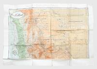
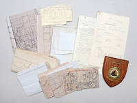
1950141716Aden & Yemen: 1950s. Into the remote places" - policing tribal disturbances in the Arabian Peninsula from the air A compelling archive of rare documents and maps. RAF operations in Aden and Yemen represented a late phase of the imperial air-policing strategy advanced by Churchill in the 1920s in response to post-Great War demobilization and Britain's expanding responsibilities in the Middle East and Africa. Claimed as a naval base on the East India route in 1839 and strengthened after the opening of the Suez Canal Aden relied on tribal treaties but as the Protectorate expanded over-stretched ground forces prompted RAF deployment from 1928 as an economical means of control. Airstrips centred on RAF Khormaksar - motto "Into the Remote Places" - supported reconnaissance leaflet-dropping and punitive strikes that helped secure the Anglo-Yemen Treaty of Friendship 1934 and later frontier policing. Reversal followed in 1954-55 with the loss of Robat while the Suez Crisis intensified unrest and Yemeni pressure leading to air attacks covert tribal agitation intervention in Oman and escalation of the frontier war into Yemen during 1958-59. The present material belongs to this volatile final phase preceding federation in 1963. Central to these operations were maps produced by the Joint Air Reconnaissance Intelligence Centre a discreet intelligence organization rooted in pre-war MI6 work. It was formalized during the Second World War and renamed in 1953 following the adoption of radar-scope photography. Headquartered at RAF Brampton and having Middle East offices in Cyprus and a detachment at Aden JARIC processed high-altitude imagery from Canberra PR9 and Victor aircraft. The archive comprises secret air-liaison instructions annotated operational maps a frontier-war-marked sketch map of Ahwar a Middle East Air Force memorandum on oxygen-mask trials RAF pilot log cards and a Khormaksar wall shield - rare survivals of evident operational use and a tangible record of Britain's final armed presence in southern Arabia. Small archive of maps memos and other documentation as detailed above. General signs of handling commensurate with active service use but overall very good. Major Michael A. Longoria "A Historical View of Air Policing Doctrine: Lessons from the British Experience Between the Wars 1919-1939" School of Advanced Airpower Studies May 1992. unknown
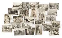
1935169367Aden: 1935-36. A superb window onto Yemen in the 1930s Two albums depicting the experiences of British servicemen stationed in Yemen around the time of the Second Italo-Abyssinian War 1935-7 mixing the documentary and the personal. The images include very rare contemporary aerial photographs of towns including Aden Ta'izz and Shibam graphic pictures of war in Addis Ababa urban military and agricultural scenes and records of free time on the RAF base at Khormaksar. Nearly all carry explanatory manuscript captions. Aden was of crucial strategic importance to the British Empire having been brought under the control of the East India Company in 1839. After the opening of the Suez Canal in 1869 it became one of the world's busiest ports. The RAF maintained a base at Khormaksar now Aden International Airport which played host to numerous squadrons throughout the 1930s. Of these No. 8 Squadron was stationed at Khormaksar for the longest period of time maintaining a policing and day-bombing role. Photographs of military aircraft belonging to No. 8 Squadron can be seen in these albums alongside pictures of planes flown by Nos 203 41 and 55 Squadrons. The photographs give a vivid impression of the volume of air and maritime traffic - mostly British but also French and Dutch - which passed through Aden after Mussolini's invasion of Ethiopia. Aerial shots show Fairey MK IIIs and Vickers Vincent planes flying in formation as well as night and day bombers and flying boats. There are also detailed close-ups of ships including British aircraft carriers. It seems probable that the photographer who assembled these albums was involved in surveying: there are fine aerial shots of Aden and Crater the Sultan's palace at Lahij Shuqra Shibam Tarim Ibb al-Mukalla and Ta'izz giving an outstanding sense of how these towns looked in the early 20th century. The pictures of Ethiopia include one aerial photograph of Addis Ababa a number of ground shots of an execution the wounded and the dead and images of buildings on fire. There is only one photograph captioned as having been taken in Somaliland but this provides a further clue that the photographer was sent from Yemen to the Horn of Africa with the intention of documenting Italian military activities there. As a result of the Second Italo-Abyssinian War Ethiopia was incorporated into Italian East Africa consisting of Italian Somalia Ethiopia and Eritrea. Britain ruled British Somaliland and France controlled French Somaliland Djibouti. Many of the images may have been taken when the photographer was off duty. There are several almost touristic shots of everyday life in Crater showing children playing and Friday prayers images taken on the beach and in the salt pans around Aden pictures of Yemeni pastoralists with their cattle and photographs of Yemeni Indian and Somali women. A significant minority of the pictures show downtime at Khormaksar with a string of images depicting airmen in fancy dress playing football and drinking. There are even two photos of the squadron's dog in a cap and glasses and with a pipe in its mouth. 2 albums. Album I with 175 silver print photographs of various dimensions 100 x 65 mm - 240 x 180 mm mounted on card. Album II with 55 silver print photographs all c.100 x 150 mm or c.75 x 100 mm. Almost all photographs with period ink captions. Album I: quarto 290 x 230 mm. Original cloth covers spine and sides decorated with pictorial designs in relief marbled endpapers 36 card stock leaves. Album II: landscape octavo 130 x 187 mm. Contemporary black card wrappers "Aden" title sticker on front cover 22 card stock leaves. Album I: superficial rubbing to spine and rear cover short splits to inner hinges fore edges nicked. Album II: rear inner hinge split glue residue to gutters. Photographs all in very good condition. hardcover
65883Yemen 1950s-1960s. 84 large-format gelatin silver prints 17.5 x 23.5cm or the reverse all with typescript caption slips in Arabic mounted to versos several captions also including series-titles e.g. 'Judges of Yemen' 'The king crown prince and Yemeni personalities' many with additional manuscript captions in Spanish. Excellent condition. An extensive visual record of the people and places of Yemen during the final years of the short-lived Mutawakkilite kingdom the majority apparently the work of a single studio based in the Arabic-speaking world and perhaps intended as an official record of Yemeni life. The Mutawakkilite regime was established after the end of Ottoman power in 1918 and lasted until 1962 when Muhammad al-Badr was deposed in a republican coup a week after succeeding his father Ahmad bin Yahya as king and imam leading to an eight-year civil war which ended in victory for the republican side. Subjects comprise: 1 Muhammad al-Badr 1926-1996 last king and imam of Yemen r.1962 5 portraits as crown prince of Yemen including one as foreign minister seated at his desk one with his uncle Sayf al-Islam 'Ali minister of science 2 during a horseback procession into Sana'a 2 photographs and one with his father Imam Ahmad this an enlarged photograph of an earlier photograph. 2 Yemeni notables 9 in total: Judge 'Abd al-Rahman al-Siyaghi minister of finance; Judge Ahmad al-Hafrani 'a man of letters of great insight and one of the greatest reciters of poetry and history'; Muhammad al-Shami minister of state and commander of the Sana'a brigade of the Yemeni army; Hasan Ibrahim minister of state and deputy foreign minister; Muhammad bin Ahmad al-Shami director of broadcasting and publications; Judge 'Abdullah al-Shawkani vice-president of the sharia council; Muhyi bin Muhammad al-Mutawakkil president of the court of appeal with assistants; Muhammad Abdullah al-Ghimizah commander of the Yemeni defence force; commander of the royal guard. 3 Daily life professions and dress 25 in total including: soldiers posed portraits and soldiers on the march; children in Ta'iz and Sana'a; teachers; tribal costume; a Yemeni 'mafraj' club or lounge; a Yemeni qaylula siesta; tennis in Sana'a; roadworks; agriculture including a coffee plantation; a student protest in support of Egypt; etc. 4 Buildings and places 21 in total including: hospitals Sana'a and Ta'iz; government ministries; mosques Janad Sana'a; palaces Ta'iz 'Dar al-Wusul'; Ta'iz airstrip; Sana'a general library; Sana'a cityscape 2 views; etc. Together with 23 further photographs: 6 of Muhammad al-Badr 9 x 14cm to 18 x 36cm depicting al-Badr addressing an open-air press conference on his arrival in Moscow 2 versions including an original large-format version on two conjoined sheets and a reduced version with typescript caption in Russian on verso attending 2 diplomatic meetings possibly in the USSR one attendee resembling Nikita Khrushchev and meeting Gamal Abdel Nasser with an informal portrait Associated Press ink-stamp and caption verso; 5 of Ahmad bin Yahya 1891-1962 King and Imam of Yemen 4 of which approx. 10 x 14.5cm 3 of these with manuscript Arabic captions on verso one depicting Ahmad and Gamal Abdel Nasser with ink-stamp and caption of Oscar Kersenbaum Argentina verso and a larger photograph 20.5 x 15cm showing Ahmad seated with Muhammad al-Badr at a victory parade Associated Press ink-stamp and caption; and 12 similar including other Yemeni notables various dimensions. Yemen, 1950s-1960s. unknown
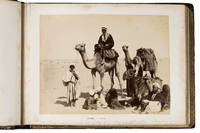
1889ABC_49512Yemen Egypt and other places 1889. Contemporary burgundy/auburn gold- and blindstamped calf lozenge-patterned blindstamping. Re-backed with the original back strip laid down. Gold-stamped turn-ins white watered silk endpapers gilt edges. Oblong folio 37.8 x 28 cm. An album containing 25 albumen prints ca. 20 x 27 cm including 1 double page mounted on thick card leaves many captioned in English. Photographic record of a journey begun in Australia and taken via Aden through the Suez canal and to the Mediterranean and then on to England. While the first image shows the steamship R.M.S. Ormuz in the port of Sydney three images including a double-page spread show the port of Aden in Yemen the famous water tanks and a native of the Southern Arabian region in a studio portrait. The majority of the album is dedicated to Egypt showing Arabs on their camels the Khedive's Ismailia Palace the Suez Canal Port Said and members the local population as well as the famous pyramids. The last few photographs show the final leg of the journey Naples and ultimately Gibraltar. Among the studios identified in the photographs are those of Hippolyte Arnoux and the Zangaki brothers based at Port Said.With a near-contemporary manuscript inscription in blue ink on the verso of the first flyleaf: "Edith Elkington or Elrington Aunt Ediths voyage home - to England about 1889". Foxed throughout slightly water stained but the prints are largely clean and clear some paper repairs in the margins the last flyleaf is lacking the final leaf is nearly detached. unknown
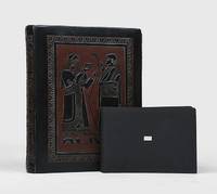
Very Good English Modern full leather each volumes in traditional Ottoman style. Roy. 8vo. (25 x 17 cm). In Ottoman script. Last 2 volumes are in Modern Turkish. 10 volumes set: ([23], 674, [10] p.; 479, [5] p.; 534, [5] p.; 432, [4] p.; 602, [6] p.; [4], 554, [5] p.; [21], 912 p.; [1], [5], 786, [4] p.; 892 p.; 1112 p)., folding maps, b/w plates. 1896 - 1938. Their contents are: Vol. 1: Description of Contantinople and environs, as of 1631. Vol. 2: Journey to Brousse and Nicomedia, 1640, Pontus, Caucasus and Crimea, 1640-44.i expedition to Crete, 1645; journey to Erzerum and Caucasus, 1648. Vol. 3: Syria, Kurdistan, Armenia, 1650; Roumelia, Bulgaria and Dobrudja, 1655-56. Vol. 4: Persia and Iraq, 1655-56. Vol. 5: Journey to Moldavia and expeditions to Transylvania and Russia, 1658; to Anatolia, then across the Dardanelles to Adrianople, 1659; expeditions to Moldavia and Dalmatia, 1660. Vol. 6: Expedition to Transylvania and journey to Albania, 1661-62; expeditions to Hungary, Montenegro and Croatia, 1663-64. Vol. 7: Austria, Crimea, Daghestan, Caucasus, Astrakhan. Vol. 8: Crimea, Crete, Salonica, Roumelia (Greece). Vol. 9: Pilgrimage to Mecca and Medina. Vol. 10: Egypt. Evliya Çelebi was son of the chief court jeweler, he was educated in a madrasah (Islamic college) and a Qur?an school in Constantinople; and, excelling as a Qur'ân reciter, he was shown favour by the reigning sultan, Murad IV. Entering the Ottoman palace school, he developed skills in Arabic, calligraphy, and music. Under the patronage of the court he began the journeys that took him from Belgrade to Baghdad and from Crimea to Cairo, sometimes as an official representative of the government and sometimes on his own. The result of these travels was his masterwork, the Seyahatname (1898-1939; 'Book of Travels'). This work is also referred to as the Tarih-i seyyah ('Chronicle of a Traveler'). Evliya possessed a vivid imagination, occasionally mixing fact and fantasy; he described places he could not possibly have visited. Noted for his fascinating anecdotes and charming style, he wrote about the ethnography, history, and geography of the Ottoman Empire and neighbouring lands and about the inner workings of the Ottoman government during the 17th century. (Source: Britannica). Currently there is no English translation of the entire Seyahatname, although there are translations of various parts. The longest single English translation was published in 1834 by Joseph von Hammer-Purgstall, an Austrian orientalist: it may be found under the name "Evliya Efendi." Von Hammer-Purgstall's work covers the first two volumes (Istanbul and Anatolia) but its language is antiquated. Other translations include Erich Prokosch's nearly complete translation into German of the tenth volume, the 2004 introductory work entitled The World of Evliya Çelebi: An Ottoman Mentality written by University of Chicago professor Robert Dankoff, and Dankoff and Sooyong Kim's 2010 translation of select excerpts of the ten volumes, An Ottoman Traveller: Selections from the Book of Travels of Evliya Çelebi. Evliya is noted for having collected specimens of the languages in each region he traveled in. There are some 30 Turkic dialects and languages cataloged in the Seyâhatnâme. Çelebi notes the similarities between several words from the German and Persian, though he denies any common Indo-European heritage. The Seyâhatnâme also contains the first transcriptions of many languages of the Caucasus and Tsakonian, and the only extant specimens of written Ubykh outside the linguistic literature. First Printed Set of Evliya Chalabi's book(s) of travels. Voyages and Travels in Greece, the Near East and adjacent regions made previous to the year 1801; being a part of a larger catalogue of work on geography, cartography, voyages and travels, in the Gennadius Library in Athens, compl. by Shirley Howard Weber, Vol. II: 1631.; TBTK 10360.; Özege .; Only 2 copies located in OCLC as set: 80395042. Rare as set.
1772376213Copenhagen: Nicolaus Moeller 1772. First edition. Engraved vignettes to title page and dedication. With 24 engraved plates some folding including two Kufic facsimiles with hand-colored diacritical marks and initials; and a large folding map of Yemen colored in outline. Genealogical table folding at p. 194. xlvii 3 431 1 errata pp. 1 vols. 4to. Contemporary quarter vellum spine titled in manuscript. Early owner signature of Andreas Narr struck out by Henricus Walther 1829. Spine soiled with old library label blind stamps to bottom of first and last leaves a clean and fresh copy. Very good plus. First edition. Engraved vignettes to title page and dedication. With 24 engraved plates some folding including two Kufic facsimiles with hand-colored diacritical marks and initials; and a large folding map of Yemen colored in outline. Genealogical table folding at p. 194. xlvii 3 431 1 errata pp. 1 vols. 4to. Attractive copy of the first publication of Niebuhr's six-year travels in Arabia Felix modern Yemen and vicinity a key work of the European exploration of Arabia. Engelmann I 127; Embacher 217; Cox I237; Henze III 611; Graesse IV 674; Gay 3589; Ibrahim-Hilmy II 66; Howgego I N24. Provenance: General Theological Seminary Nicolaus Moeller unknown
New Arabic Original cloth bdg. 592 p. In Arabic. Elephant folio. (49 x 35 cm). First Edition. Illuminated. Reprinted from the original manuscript of Topkapi Palace Museum dated 1584-87. The Koran known as Ahmed Karahisarî's Mushaf-i Serif is leading among the most important works created by artists, who are experts of letters of the Ottoman Palace dealing with the art of books. The work is registered at number 5 among the Hirka-i Saadet books of the Library of Topkapi Palace Museum. Its binding with golden gilded ornament, angle and border has miklep and is made of black leather and was repaired in time. Being the Koran with the largest size written in the Ottoman world, is sized 61.5x42.5 cm and consists of 300 sheets. The place of the work where the name of the calligrapher and the date of transcription would have been written, i.e. the colophon is left empty. The reason for attributing it to Ahmed Karahisarî, the famous calligrapher of the period of Kanunî Sultan Suleyman, is based on a foundation record at its beginning: in this foundation record on page 1b, it is briefly stated that the work is the Mushaf-i Serîf of Karahisarî, was kept in the sultan's treasure until then and was devoted to the Hirka-i Serîf Chamber (Private Chamber) for being recited in 1107 (1696) by Sultan Mustafa II. The beginnings of Fâtiha and Bakara chapters of the Koran, every page of which is gilded carefully, are written with celî muhakkak (large cursive style) and reyhanî calligraphy. Two opposed pages following the epigraph demonstrate a different arrangement. Here, one line each of celî calligraphy at the bottom and top and reyhanî calligraphy in a round medallion at the middle are used. In the opposed pages following this, the same arrangement is used without the medallion. Following this diversity at the beginning, the Koran is written according to a classical arrangement known as Yakut style, consisting of one line of celi muhakkak, five lines of nesih (roundish writing), one line of celî sulus (large style), again five lines of nesih and celî muhakkak calligraphy at the bottom. Ahmed Karahisarî is the most famous artist writing in this style among 16th century Ottoman calligraphers. However, it is quite surprising that the signature of Ahmed Karahisarî, who had great reputation in his time, is not seen at the end of the work. This can be explained by the failure to complete the Koran of the artist due to his death or his old age. It is possible to determine the period in which the work, accepted to be written by Ahmed Karahisarî, famous calligrapher of the time of Kanunî Sultan Suleyman, and incorporating the richest examples of Ottoman palace gilding art was completed with its main lines in the light of some documents.It is understood that 220 pages of the Koran known as Ahmed Karahisarî Mushaf-i Serif and which is one of the most valuable works of Topkapi Palace Museum were written by Karahisarî at the time of Kanunî Sultan Suleyman between 1545-55 and was left unfinished upon the death of the artist. It is also understood that the remaining 80 pages completing the Koran were possibly written by Hasan Celebi, his adoptive son, under the patronage of Sultan Murad III between 1584-87. Conjunction, drawing of rulers, gilding of every page and binding and final completion of the work was performed between 1584-1596. Murad III, who died in 1595, could not see the result of this study that he assumed the patronage of for long years.
1962171426Sana'a: c.1962. Mining the border between north and south Yemen First and sole edition of this map of North Yemen with unique additions marked "top secret" in Arabic and annotated Kharitah tanbih mawaqi' al-algham "mashru' rif'at" "A map of briefing of the locations of mines of the Rifaat Plan". Although the map itself is undated and information about the "Rifaat Plan" is not publicly available it is possible that the strategy was connected to the Egyptian military officer Kamal Rifaat who visited the Yemen Arab Republic along with Anwar Sadat just after its establishment in 1962. Subsequently the Egyptians provided the YAR with a great deal of military support and advice as Abd Allah al-Sallal the country's first president fought the Federation of South Arabia later South Yemen. The long period of confrontation between North and South Yemen extended throughout the 1970s from the First Yemenite War of 1972 to the Second Yemenite War of 1979. Mines were also laid on the border before the two countries were unified in 1990 and have continued to be planted in subsequent conflicts until the present day. The map shows schematic clusters of minefields beginning due east of Sana'a around Meghdal extending in a line northwards to Wa'ir and then northwest to Jabal Mara' on the border with Saudi Arabia. The consequence of laying these minefields would have been to entrench the border between North and South Yemen the course of which they mirror almost exactly. It is annotated in pencil and colour pencil. Colour map 1000 x 690 mm. Text in Arabic. Creased where folded short closed tears and holes along fold lines and extremities a little soiled in places: a very good copy. unknown
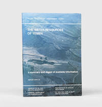
167682Sana'a and Delft: Printed for Ministry of Oil and Mineral Resources General Department of Hydrology; TNO Institute of Applied Geoscience 1995. With attractive maps and cross-sections First edition first printing consolidating hydrological data on Yemeni geography information sources climate monitoring networks and surface- and groundwater with a particular focus on evapotranspiration and flash flows. An institutional search locates only seven copies in Europe and the US. The Yemen Arab Republic formed the General Department of Hydrogeology GDR in 1978 and the Yemeni-Dutch Water Resources Assessment Yemen WRAY programme was launched four years later. WRAY investigated the water resources while building a public database and its fourth phase began in 1990 to ensure the GDR's self-reliance and consolidate earlier findings. The study focuses on western areas such as Tihama Al Jauf and Marib while the east is largely limited to the Wadi Hadhramaut. It looks at ancient water systems such as the old Marib Dam the collapse of which is noted in the Koran. Also shown is spate irrigation illustrated by Van der Gun's map of Wadi Surdud. Ghayls open canals capturing groundwater are identified as future study potential. Modern projects are assessed including the new Marib Dam and irrigation project and the increasing challenges of groundwater depletion are examined. Folio. With 6 colour folding maps and colour geological cross-section illustrations in the text. Original illustrated wrappers front wrapper lettered in white. Some rubbing of extremities soiling of rear wrapper end edges of text block internally clean. A very good copy. unknown
1852X114460Göttingen, Dieterichschen Buchhandlung 1852 Complete in 2 parts in one physical volume, [4] + [82] + [106] pp. (containing resp. 24 and 27 genealogical tables), in oblong (23x32cm.), solid modern amateur hardcover (marbled boards, spine in cloth), pages are clean and bright, good condition, [N.B. The "Register" to this work, published in 1853, is not included], weight: 1kg., X114460
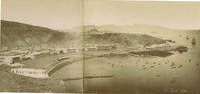
71236c.1880. . Albumen print. Four-part panorama very good tonal range and in good condition.<br /> <br /> [c.1880]. unknown
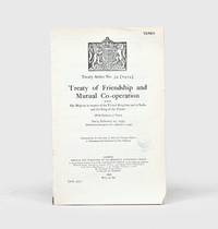
1934164042London: His Majesty's Stationery Office 1934. First English-Arabic edition first impression of the diplomatic agreement which acknowledged "the complete and absolute independence of His Majesty the King of the Yemen the Imam and his kingdom in all affairs of whatsoever kind" p. 2. In June 1934 shortly after this agreement was concluded Ibn Saud and Imam Yahya signed the Treaty of Taif which brought an end to armed hostilities between the two countries. In this development Britain had played a major part with its support for Yemen and comparatively lukewarm stance vis-à-vis Ibn Saud helping to both precipitate military conflict and ultimately bring it to an end. The English text of the treaty without the ratifications was first published earlier in the year as HMSO Yemen No. 1. Octavo 232 x 151 mm pp. 11. Royal coat of arms of the UK on first page. Sometime disbound with no subsequent stitching. Small faint Admiralty ink stamp dated 14 December 1934 on first page. Light creasing and skinning where previously bound a few nicks small chip at foot of first leaf text bright. A very good copy. unknown
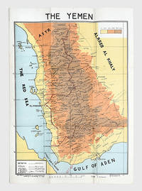
178175Egypt: M. Louts 5 January 1972. With manuscript route annotations First edition here labelled "The Yemen". It is drawn by the elusive cartographer usayn Abd All h Dham r appearing as H. Althamary who also produced a map of San a . Only three institutional copies are recorded in WorldCat at Leiden the Library of Congress and Michigan. An Arabic edition and a second English edition were published in 1976. The map is in idiosyncratic English and marks the strategically important governorates of Taiz al-Bayda and Ma rib. Several words are misspelled including "drawen" "boundries" and "vally." The eastern border is left blank excluding the independent People's Democratic Republic of Yemen. A brief border war took place in October 1972 ending with the Cairo Agreement which proposed unification of the two Yemeni states. Each was backed by opposing Cold War powers: Saudi Arabia supported the Yemen Arab Republic while the Soviet Union backed the other. The two states ultimately united in 1990 as the Republic of Yemen. The route annotations in red pen stretch from Najran in the north to the Bab al-Mandab Strait in the south. Colour map 660 x 463 mm scale 1:1000000 text in English. Old fold marks a few small holes at folds small chip to head not affecting text a little offsetting at lower margin: a very good copy. Warren P. Aston "The Origins of the Nihm Tribe of Yemen: A Window into Arabia's Past" in Journal of Arabian Studies: Arabia the Gulf and the Red Sea 4:1 2014 pp. 134-148. unknown
1976168409San a: Yemen Arab Republic Government 5 January 1976. Second edition labelled here as "The Yemen". It is drawn by the elusive cartographer usayn Abd All h Dham r here appearing as H. Althamary who also produced a map of San a . We have identified only six institutional copies on WorldCat at Exeter Leiden NLS Cornell LoC US Geological Survey. The first edition was published in Egypt in 1972 while an Arabic edition appeared in 1976. The map is in idiosyncratic English and marks the strategically important governorates of Taiz al-Bayda and Ma rib. Several words are misspelled including "drawen" "boundries" and "vally." The eastern border is left blank excluding the independent People's Democratic Republic of Yemen. A brief border war took place in October 1972 ending with the Cairo Agreement which proposed unification of the two Yemeni states. Each was backed by opposing Cold War powers: Saudi Arabia supported the Yemen Arab Republic while the Soviet Union backed the other. The two states ultimately united in 1990 as the Republic of Yemen. Colour lithographed map 655 x 450 mm scale 1:1000000; later laid down on board; white wooden frame overall 690 x 490 mm; text in English. Slightly toned some creasing one small hole: a very good copy. Warren P. Aston "The Origins of the Nihm Tribe of Yemen: A Window into Arabia's Past" in Journal of Arabian Studies: Arabia the Gulf and the Red Sea 4:1 2014 pp. 134-148. unknown
1920X119387Leiden, E.J. Brill 1920-1923-1942 Complete work in 3 volumes, xi + 2976 + xxxiv pp. (continuous pagination), with a frontispiece in colour in volume I, uniform blind solid hardover bindings, text and interior are clean and bright, rare complete set, good condition, weight: 4.6 kg., [The 3rd volume was published by K.V. Zettersteen], X119387
171621801A Amsterdam, chez Steenhouwer et Uytwerp, 1716. In-12 de [16]-343-[13] pages (dernier feuillet blanc) :*8;A-N12; P4;Q6. Pleine basane brune, dos à nerfs orné de filets et fleurons dorés, pièce de titre beige, tranches rouges.
1962164052Rome: Centro arabo di informazioni 1962. First edition first printing scarce of this booklet published by the League of Arab States's communications body in Italy. The three maps show de facto and indefinite boundaries on the Arabian Peninsula in Aden and in Muscat and Oman. We have traced four institutional copies all of which are in Italy. The text surveys British activity in the region from the early 19th century through to the present day with sections on the Ottoman empire the First World War the 1934 peace treaty and the structure of the Aden Colony and Protectorates. Octavo. With 3 folding maps. Original card wrappers wire-stitched as issued front cover lettered in blue. Wrappers lightly toned and foxed contents clean with just couple of spots. A near-fine copy. unknown
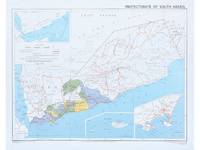
1964182178Surrey: Directorate of Overseas Surveys 1964. Later edition printed in the second year of the protectorate. In addition to showing the states of Kathiri Mahra and Qu'aiti it also highlights the members of the Federation of South Arabia in colour and features three inset maps which show the entire region the island of Socotra and the State of Aden. The Directorate of Overseas Surveys was established in 1946 with responsibility for surveying parts of the British Empire that did not have the resources to otherwise map themselves. "The Directorate was charged with two key tasks. It was to provide national geodetic frameworks throughout the British Empire that would contribute to understanding the size and shape of the earth and constitute the basis for accurate mapping. It would also produce mapping using modern methods based on aerial photography. This would in turn help to inform the development and administration of each country" Natural Collection of Aerial Photography. This copy is the fourth edition. Colour map 324 x 406 mm printed on recto only key on recto. Map bright a little bowed sometime folded with a vertical crease at centre slightly creased at edges: a very good copy. National Collection of Aerial Photography "Directorate of Overseas Surveys". unknown
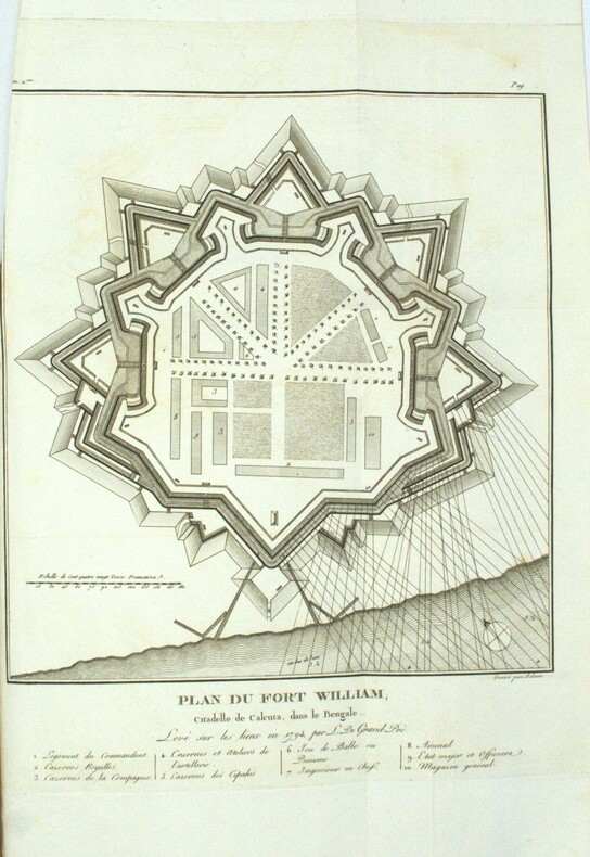
1801PHO-1972Paris, Dentu, an IX (1801); Atlas seul, in-4 (33x24,5cm),composé de 7 planches gravées dépliantes dont une grande vue de la citadelle de Calcutta et un plan du Fort William.. Bel exemplaire, relié basane époque, roulette aux plats et à l’intérieur, tranches dorées, manque au dos, coins usés, intérieur frais.
New Arabic Original bdg. 4to. In Arabic and Turkish. 2 volumes set: (77, 1563, 72 p.). Mushaf-i Serif (Topkapi Sarayi Müzesi nüshasi, Medine Nr. 1). 2 volumes set. Prep. by Tayyar Altikulaç. One of the main chapters of IRCICA s research program titled "Studies on the Holy Quran" consists of analytical and comparative studies on historical and physical features of early copies of the Holy Quran which are located at different places around the world. These studies, published by IRCICA, not only enrich the academic literature in the field but also highlight the clear evidence of the authenticity of the Holy Quran, thus refuting some Western +authors suggestions to the contrary. The following volumes have been published by IRCICA in this series, in the order of publication: the copies attributed to the time of the Third Caliph, Othman bin Affan RA and preserved, respectively, at Topkapi Palace Museum in Istanbul and the Central Library of Islamic Manuscripts (originally founded as Mashhad al-Husayn) in Cairo; the copy attributed to the time of the Fourth Caliph Ali bin Abi Talib KAW and located in the Manuscripts Library near Sana a Grand Mosque, that attributed to the period of the Third Caliph, Othman bin Affan RA and preserved at the Islamic Arts Museum in Cairo, the partial copy preserved at the National Library of France, Paris, the partial copy at Tubingen University Library, Germany, the partial copy at British Library, London, the copy located at State Library in Berlin, Germany, and now, a two-volume study on the copy which is located in the collection of Fahreddin Pasha ("Defender of Madina" during World War I) at Topkapi Palace Museum Library, Istanbul. This new book contains the scholarly study by Dr. Tayyar Altikulac, specialist of studies on the Holy Quran and ex-President of Religious Affairs in Turkey, on this copy. The latter was brought from Madina to Istanbul by Fahreddin Pasha. The study is composed of elaborate chapters written with utmost depth and meticulosity. Some of the subjects dealt with are: the history of the copy, its physical condition and contents, its descent, its relationship with the known pronunciations, its orthography, the period when it was copied, and the method applied in the study.
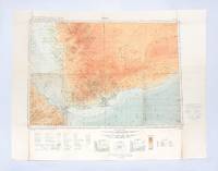
1930182334London: Geographical Section General Staff War Office 1930. Later impression overprinted with a Cassini grid in 1930 following the first edition of 1926. This map of the Aden Protectorate and its neighbours was produced for the International Map of the World a project that aimed to create a complete world map at a 1:1000000 scale. It covers South Yemen and the Hadhramaut as well as the tip of French Somaliland. The International Map of the World or the Millionth Map of the World was first proposed by German geographer Albrecht Penck in 1891. The project was adopted by ten countries in 1909 who agreed to follow consistent rules and standards for mapping their own territories. While countries like the US and UK made strides at first "production was slow in the earlier years since it was first necessary to complete basic surveys for the required data and during and after World War II there was little interest in pursuing the project" Ency. Brit. Colour lithograph map 648 x 856 mm linen-backed perhaps not as issued key printed on recto; text in English and French. A little foxed dust-soiling slight wear and a few small holes along fold lines: a very good copy. unknown
1740A131-2661Amsterdam / Venezia, Tirion / Giovanni Battista Albrizzi, c. 1740. Landkarte, Kupferstich, koloriert, 27 x 33 cm / Map, copperplate engraving, coloured, 27 x 33 cm
New Turkish Original aesthetics full leather bdg. in traditional Ottoman style. With flap (miklep). In publisher's special luxury box. Large 4to. (30 x 25 cm). In Arabic. All edges gilt. Fully illuminated as traditional: Serlevha, hecde hizb, cüz roses, zahriye semses, müsenna besmele, with 'tevafuk' and color secavends, and med-kasirs. 605, 11, [4] p. The glorious Quran. Kur'an-i Kerim. was an Islamic calligrapher born during Ottoman times. His real name is Sheikh Musa Azmi, which is why his works may be found to be signed as Azmi. He is known by the pseudonym Hamid. He is also known as Hamid Al Amidi in international circles. Hamid learned the jali-thuluth (Turkish: celi-sülüs) style from Mehmed Nazif (1846-1913), the naskh and thuluth styles from Kamil Akdiç (1862-1941) and the ta'liq style from Mehmed Hulusi (1869-1940). His works are on display in many countries including Egypt and Iraq. His works are also on display in many newly built mosques of Istanbul. Some of his popular students include Hasan Çelebi and Fuat Basar. He was buried in the Karacaahmet Cemetery of Üsküdar district, Istanbul.
60392c. 1880s. . Panorama two albumen prints pasted on original card 20 x 50 cm title in negative. Good tonal range and in good condition.<br /> <br /> [c. 1880s]. unknown
Very Good Turkish, Ottoman (1500-1928) Paperback. With a pictorial cover. Large roy. 8vo. (23 x 18 cm). In Ottoman script [and French on the cover]. 355-442 pp., ills. Bilingual cover is written 'Medeniyet Ordusu Yemen çöllerinde' and 'L!Armee dans le Desert de Yemen' bilingual in Turkish with Arabic script and in French. [i.e. The Ottoman civilized army in the desert of Yemen]. Extremely rare.