3 525 résultats
First English edition of Der Judenstaat, published in German in the same year. [xii], 102, [1] ad, pages. "Let the sovereignty be granted us over a portion of the globe large enough to satisfy the reasonable requirements of a nation; the rest we shall manage for ourselves". - p.25. In his July 10, 1896 diary entry Herzl wrote "Paid the publisher David Nutt 19 pounds and a few shillings for the English edition. He has sold only 160 copies". - p.414 of "The Complete Diaries of Theodor Herzl". Moderate external soiling. Above-average external wear with a variety of small chips from and short openings to the thin paper covers. Binding intact. Prior owner's details in pencil, dated 1896, atop half-title, otherwise unmarked. A sound copy of this profoundly influential work by the acknowledged father of the Jewish state. Emanuel p.53 Book
185964885London, James S. Virtue, (1858-1859). Gr.-Fol. (45 x 33 cm). Mit zus. 76 auf Untersatzkartons mont. Orig.-Fotografien (Albumin) von Francis Frith u. 82 nn. Bll. Text. HLdr.-Bde. d. Zt. m. goldgepr. Rückentiteln u. marmor. Schnitt.
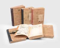
19231784971923-31. Policing Palestine An absorbing day-to-day record of British policing in Mandatory Palestine these diaries chart the volatile years from 1920 to the early 1930s offering a granular view of religious and social tensions and of Britain's often self-serving pursuit of "law and order". Major Laurence Harrington joined the Palestine Police at its inception in July 1920 rose rapidly and served mainly in Jerusalem and Jaffa. He witnessed the 1929 disturbances and later gave evidence to the Shaw Commission. His diaries consist of brief functional entries kept for official purposes with gaps when volumes were sent for inspection and frequent references to named officers and local figures. Religious violence dominates the record. Harrington repeatedly investigates killings framed explicitly in religious terms orders precautionary deployments and manages flashpoints such as Labour Day nationalist demonstrations anniversaries strikes and boycotts. He records crowd control operations armed patrols prison break-outs manhunts with shoot-to-kill authority and the tense aftermath of the 1929 riots including censorship confiscations and plain-clothes operations to suppress unrest. Alongside this the diaries document routine but hazardous police work - drug-smuggling busts raids on suspected agitators and the exposure of corrupt informants - as well as Harrington's ceremonial duties escorting senior British officials and visiting dignitaries. His proximity to power brings an active social life offset by football as a constant release. The final volume anticipates the worsening climate of the 1930s with police on continual alert for political and communal triggers. No other diaries by Harrington are known to survive making this candid administrative record an unusually fortunate and valuable witness to the mandate's daily realities. 6 vols octavo. Original quarter cloth five black one red rebacked boards lettered in black. Bindings rubbed covers with splash stains and tidemarks and labels torn away internally some foxing and finger soiling. Overall in condition commensurate with maintaining a diary on active duty: well preserved. hardcover
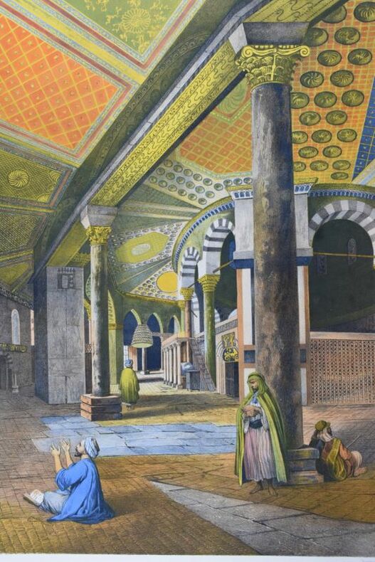
3 parti in un grande volume in-folio, pp. 47 e 24 belle tavole a colori f.t. Legato con: "Vues dans l'Empire Ottoman principallement dans la Caramanie...". Londres, 1803. pp. 40 e 24 tavole colorate a mano. Segue:"Vues en Egypte d'après les dessins originaux en la possession de Sir Robert Ainslie"... A Londres, 1802. pp. 109, (3) e 48 tavole. Elegante e solida legatura in mezzo marocchino rosso moderno con titolo oro, fregi al dorso a nervi. Maestosa opera riccamente illustrata da 96 acquatinte colorate da mano coeva. Bell'esemplare in prima edizione di questa raccolta di opere di Mayer. L'artista italiano Luigi Mayer venne incaricato da Sir Robert Ainslie di realizzare dipinti ed incisioni delle località dell'Impero Ottomano. Dal suo soggiorno a Costantinopoli in qualità di ambasciatore Sir Robert portò diversi disegni originali che servirono a Mayer per queste incisioni spettacolari ed esotiche della Palestina dell'Egitto e di Costantinopoli. Nato in Germania, Luigi Mayer studiò a Roma presso la bottega di Piranesi . Nel 1792 Mayer fu assunto quale assistente artistico di un giovane inglese (Sir Ainsle) che stava compiendo un tour in Oriente. Il 20 settembre 1775 Ainslie fu designato quale successore di John Murray come ambasciatore britannico alla Porta Ottomana e lo stesso giorno fu nominato Pari d'Inghilterra. Nel maggio del 1776 partì alla volta di Costantinopoli. Il nuovo sultano 'Abd-ul-hamid, che succedette nel 1774, auspicava dei rapporti più stretti con l'Inghilterra, sia commerciali che politici ed instaurò con Ainslie un'ottima amicizia che gli permise di adattarsi felicemente alla vita di Costantinopoli affezionandosi ai costumi della popolazione. . Blackmer 1097 (1801 edition), 1099, 1098; Abbey, Travel 369; Atabey 785 (1801 edition), 786..
"Whatever place its author may ultimately occupy in future histories of England, one thing is certain, that in the history of the Jewish people the name of Balfour will enjoy unchallenged immortality, evoking comparison with that of Cyrus, for the issue of the Balfour Declaration marked the opening of a new epoch in the annals of Jewry which will be recognised as such even in the remotest centuries to come. In this little book have been gathered together all the utterances of Lord Balfour on the interpretation and implications of his Declaration, on its political aspects and its practical realisation, made during the last ten years." - Preface. [4], 5-128 pp. 7" x 4.75". Original spine label present and intact. Front free endpaper professionaly replaced. Tanning to central portion of half-title. Prior owner's ink stamp upon title page. Duplicate spine label bound at p.128. Average external wear. Binding intact with moderate forward lean. No dust jacket, presumably as issued. Quarter inch notch from top of backstrip. A sound copy of this jewel of Zionist history. EMANUEL p.48. [ASIN B000852UV4] Book
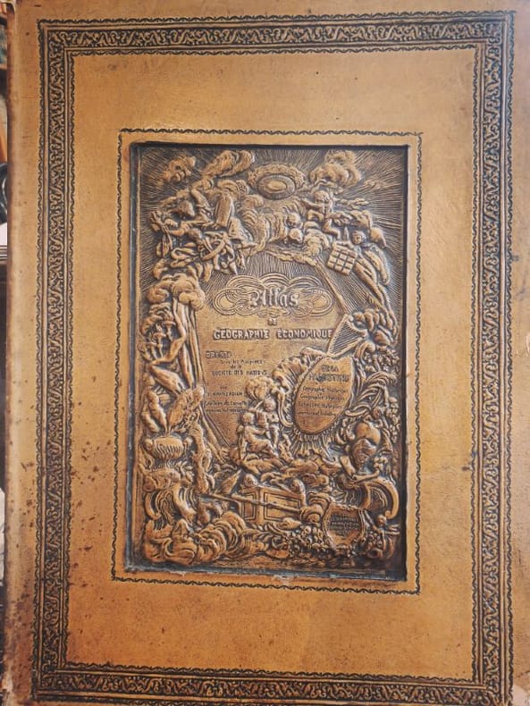
1932LCI-6454Editions geographiques Khanzadian 1932 1 Folio feuillets sous coffrage RARETÉ HISTORIQUE — EXEMPLAIRE DÉDICACÉ — FORMAT FOLIO — ÉTAT EXCEPTIONNELL’Atlas de géographie générale de la Palestine (1932) — rédigé par la Société des Nations (SDN) — est un témoignage cartographique unique d’une époque où la géopolitique du Proche-Orient était redéfinie. Rareté absolue : Très peu d’exemplaires subsistent, surtout en format folio — ce qui en fait un objet imposant, rare et prestigieux. Preuve sociale forte : Ce livre a été utilisé par des institutions académiques et des diplomates de l’époque — aujourd’hui, il est recherché par les chercheurs sur la Palestine pré-1948. Contexte géopolitique brûlant : Dans un monde où la Palestine est au cœur des débats, cet atlas devient un artefact politique et historique vivant — un outil de compréhension, pas seulement un objet. Contenu détaillé : L’atlas comprend 135 cartes en noir et en couleur, couvrant :La géographie physique et humaine de la PalestineLes frontières et les territoires administrés par la SDNLes ressources naturelles et les infrastructuresLes données démographiques et religieusesLes zones de conflit et les projets de développement Dédicace manuscrite de l’auteur — une connexion personnelle avec l’histoire, rare et émouvante. État du cartonnage : Légères usures aux angles — signes d’authenticité et d’usage historique — mais reliefs centraux magnifiques, soulignant l’élégance originale de la reliure.Ne cherchez pas ailleurs — ce n’est pas un livre, c’est un témoignage.
24766672 original photograps size 25 x 31 cm mounted on 64 heavy cardboards. Contemporary red half calf rubbed inner hinges cracked. Some foxing to cardboards. . hardcover
Very Good English Modern full leather each volumes in traditional Ottoman style. Roy. 8vo. (25 x 17 cm). In Ottoman script. Last 2 volumes are in Modern Turkish. 10 volumes set: ([23], 674, [10] p.; 479, [5] p.; 534, [5] p.; 432, [4] p.; 602, [6] p.; [4], 554, [5] p.; [21], 912 p.; [1], [5], 786, [4] p.; 892 p.; 1112 p)., folding maps, b/w plates. 1896 - 1938. Their contents are: Vol. 1: Description of Contantinople and environs, as of 1631. Vol. 2: Journey to Brousse and Nicomedia, 1640, Pontus, Caucasus and Crimea, 1640-44.i expedition to Crete, 1645; journey to Erzerum and Caucasus, 1648. Vol. 3: Syria, Kurdistan, Armenia, 1650; Roumelia, Bulgaria and Dobrudja, 1655-56. Vol. 4: Persia and Iraq, 1655-56. Vol. 5: Journey to Moldavia and expeditions to Transylvania and Russia, 1658; to Anatolia, then across the Dardanelles to Adrianople, 1659; expeditions to Moldavia and Dalmatia, 1660. Vol. 6: Expedition to Transylvania and journey to Albania, 1661-62; expeditions to Hungary, Montenegro and Croatia, 1663-64. Vol. 7: Austria, Crimea, Daghestan, Caucasus, Astrakhan. Vol. 8: Crimea, Crete, Salonica, Roumelia (Greece). Vol. 9: Pilgrimage to Mecca and Medina. Vol. 10: Egypt. Evliya Çelebi was son of the chief court jeweler, he was educated in a madrasah (Islamic college) and a Qur?an school in Constantinople; and, excelling as a Qur'ân reciter, he was shown favour by the reigning sultan, Murad IV. Entering the Ottoman palace school, he developed skills in Arabic, calligraphy, and music. Under the patronage of the court he began the journeys that took him from Belgrade to Baghdad and from Crimea to Cairo, sometimes as an official representative of the government and sometimes on his own. The result of these travels was his masterwork, the Seyahatname (1898-1939; 'Book of Travels'). This work is also referred to as the Tarih-i seyyah ('Chronicle of a Traveler'). Evliya possessed a vivid imagination, occasionally mixing fact and fantasy; he described places he could not possibly have visited. Noted for his fascinating anecdotes and charming style, he wrote about the ethnography, history, and geography of the Ottoman Empire and neighbouring lands and about the inner workings of the Ottoman government during the 17th century. (Source: Britannica). Currently there is no English translation of the entire Seyahatname, although there are translations of various parts. The longest single English translation was published in 1834 by Joseph von Hammer-Purgstall, an Austrian orientalist: it may be found under the name "Evliya Efendi." Von Hammer-Purgstall's work covers the first two volumes (Istanbul and Anatolia) but its language is antiquated. Other translations include Erich Prokosch's nearly complete translation into German of the tenth volume, the 2004 introductory work entitled The World of Evliya Çelebi: An Ottoman Mentality written by University of Chicago professor Robert Dankoff, and Dankoff and Sooyong Kim's 2010 translation of select excerpts of the ten volumes, An Ottoman Traveller: Selections from the Book of Travels of Evliya Çelebi. Evliya is noted for having collected specimens of the languages in each region he traveled in. There are some 30 Turkic dialects and languages cataloged in the Seyâhatnâme. Çelebi notes the similarities between several words from the German and Persian, though he denies any common Indo-European heritage. The Seyâhatnâme also contains the first transcriptions of many languages of the Caucasus and Tsakonian, and the only extant specimens of written Ubykh outside the linguistic literature. First Printed Set of Evliya Chalabi's book(s) of travels. Voyages and Travels in Greece, the Near East and adjacent regions made previous to the year 1801; being a part of a larger catalogue of work on geography, cartography, voyages and travels, in the Gennadius Library in Athens, compl. by Shirley Howard Weber, Vol. II: 1631.; TBTK 10360.; Özege .; Only 2 copies located in OCLC as set: 80395042. Rare as set.
In-4 (mm. 310x200), 2 parti in 1 volume (ciasc. con proprio frontesp.), p. pelle bazana coeva (restaurata), dorso a cordoni (rifatto), pp.num. (6),220,(4, di Indice); (2),456,(8, di Indice), con una bella antiporta allegorica incisa, titolo in rosso e nero, testo su due colonne. il volume è arricchito da una straordinaria documentazione iconografica di 39 tavole inc. in rame f.t. (come da Indici) così composte: 31 tavole (di cui 23 a doppia pagina e a volte anche ripieg.) che illustrano bellissime vedute delle più importanti località (tra cui Damasco, Aleppo, Tripoli, Jaffa, Rama, etc.), la storia, gli usi e i costumi dei Siriani e dei Palestinesi e 8 grandi carte geografiche + 34 preziose vignette, sempre inc. in rame, nel t. La città di Gerusalemme è raffigurata anche in un magnifico panorama a volo d’uccello, più volte ripieg. Rara "prima edizione" tedesca di questa famosa opera sul Medio Oriente, scritta dapprima in lingua olandese nel 1677; l’edizione tedesca fu tradotta e pubblicata da Jacob von Meursen, autore anche delle incisioni in rame che la illustrano. Cfr. Tooley’s Dictionary of Mapmakers, p. 147 - Graesse,II, 335. "Olivier Dapper (1636-1689), médecin hollandais, joignit à la pratique de son art l'étude de l'histoire et surtout de la géographie. Il recueillit tout ce qui pouvait faire connaitre les pays étrangers, et composa des descriptions très étendues et très intéressantes. Il orna ses ouvrages de cartes et de figures nombreuses. Les planches, bien dessinées et gravées avec soin, représentent avec assez de fidelité les lieux les plus importants et les usages des habitants. Parmi ses ouvrages (sur l'Afrique, l'Asie, la Perse, l'Amérique et la Terre australe), la ‘Description de l’Asie, contenant la Syrie et la Palestine ou la Terre Sainte’, traduit en allemand, Amsterdam, 1681, c’est le plus beau des ouvrages de Dapper”. Cosi' Biographie universelle,X, p. 538. Con antichi restauri solo margin. su alc. carte (e a p. 211 della prima parte, per un lungo strappo), tracce d’uso più o meno pesanti e qualche alone, ma complessivam. buon esemplare.
18626478Paris, Librairie Maritime et scientifique Arthus Bertrand, 1862. In-plano (600 x 464 mm), 1 f. de titre illustré du plan du Saint-Sépulcre, 2 ff. de texte et 14 planches lithographiées (dont 12 en couleurs) par Hubert Clerget, Bachelier, Jules Gaildrau et Fichot. Sous un boîtier moderne en toile, le premier plat illustré d'une photocopie de la page de titre, page de titre salie en marge avec traces de déchirures, il est entièrement doublé, les feuillets de texte ont probablement été lavés, les planches sont dans un état parfait. Bel exemplaire parfaitement complet.
In -Folio, piena pergamena con titolo manoscritto al dorso; (8), 448, 4 tavv.
180412547A Paris, Imprimerie de Crapelet, 1804. 2 vol. in-4 de (4)-VIII-514 pp. 1 frontispice et 38 planches ; (4)-534 pp., 1 carte gravée dépliante, 1 frontispice et 34 planches, maroquin rouge à grains longs, dos à cinq nerfs minces orné de pointillés et feuilles, cadre à une roulette aux volutes florales sur les plats, filet strié sur les coupes et les coiffes, doublures et gardes de tabis bleu, tranches dorées (Rel. P. Bozerian jeune).
35012Paris de l'imprimerie de Gérard Jollain, sans date (début XVIIIe, 1703?) 1703 in 4 oblong (18,5x25) 1 volume reliure plein velin granité de l'époque, dos à nerfs muet, page de titre gravée illustrée, et 147 planches gravées numérotées de 1 à 148 (la planche portant le N°100 manque, la marge latérale externe de la planche 134 est légèrement plus courte). Rare recueil édité par Gérard Jollain. Dimension: 175 x 245 mm. De très nombreuses planches portent la mention: Jollain [Gérard] excud. Relié à la suite: VITA ET MIRACULA CHRISTI EX NOVO TESTAMENTO. LA VIE ET LES MIRACLES DE JESUS CHRIST, tiréz du nouveau testament. Gérard Jollain excudit, Colongne, page de titre gravée illustrée, et 120 planches gravées numérotées de 1 à 120 (la dernière planche gravée est doublée), Des planches gravées portent la mention: Jollain [Gérard] excud. et les planches 51, 59 75 portent la mention: F. Canpion fecit [ François Campion ]. Très rare et précieux recueil en reliure de l'époque renfermant 267 planches gravées, et 2 pages de titre gravées illustrées, l'ensemble en très beau et contrasté tirage. Bel exemplaire ( Photographies sur demande / We can send pictures of this book on simple request )
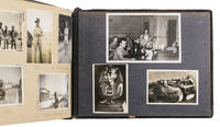
1940ABC_484251940. Contemporary embossed brown calf with flowers on the front and back board and an aluminium view of David's Tower and Jerusalem's old city wall embedded in the front board. Oblong album 30 x 20 cm. With 128 gelatin silver prints most ca. 6.5 x 9.5 cm. Beautiful album with 128 photographs of Egypt and Palestine present day Israel and the West Bank during the British Mandate. It was likely compiled by a British soldier who was stationed in the Middle East during the 1940s. Some of the photographs are numbered in the negative and may have been made by important photographers active in the area at the time like G. Eric Matson and his wife Edith the founders of the Matson Photo Service. The images show Cairo and various locations in Palestine including Jerusalem Bethlehem Nazareth Tiberias Sea of Galilee Nathanya Tel Aviv the Jordan river Haifa Beirut and the Dead Sea. Other than important locations like churches and gates the photographs also show many locals including for example street barbers in Cairo shepherds and farmers in Palestine and beautifully dressed women in Haifa. In the back of the work a few dried leaves from local plants have been mounted namely orange lemon fig eucalyptus grapevine and mulberry. The eucalyptus leaf still retains some of its scent.The edges and vorners of the boards are somewhat scuffed with some loss of material at the head and foot of the spine and around the edges of the embedded aluminium plate. The photographs mounted on the inside of the front board are slightly stained the fig leaf mounted on one of the final pages is damaged and the cyprus leaf is missing. Otherwise in good condition. unknown
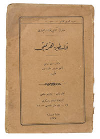
1919ABC_47443Istanbul: Matbaa-yi Orhaniye 1919. Original publisher's orange printed paper wrappers. 8vo ca. 18.5 x 12.5 cm. With the Turkish text printed using Arabic script. First and only edition of a report about the Sinai and Palestine campaign 1915-1918 in Ottoman Turkish translation. This second half of this campaign was led by General Edmund Henry Hynman Allenby 1st Viscount Allenby 1861-1936. He commanded the Egyptian Expeditionary Force EEF then part of the British army against the Ottoman Empire in the conquest of Palestine in 1917-1918. The EEF succeeded in capturing Beersheba Jaffa and Jerusalem in late 1917 as well as the Jordan valley and Northern Palestine in 1918. The present work is a translation of Allenby's reports which cover the period between December 1917 when the British entered Jerusalem and September 1918 when General Allenby started a new campaign resulting in the capture of Damascus and Aleppo. The report begins with operations to make Jaffa and Jerusalem safe against Turkish counterattacks and continues with Allenby's succesful attacks on Jericho the Jordan Valley and As-Salt. The EEF won numerous other battles in the region before the Armistice of Mudros ended the campaign in October 1918. Allenby then became the High Commisioner in Egypt and Sudan from 1919-1925.With an inscription on the title page and on the back wrapper. With a water stain on the head margin throughout including the wrappers the spine is somewhat torn but the wrappers are still connected. Somewhat browned throughout the edges of the leaves are frayed the leaves are folded and loose in the wrappers as issued. Otherwise in good condition.l WorldCat 777059280 3 copies; Özege 5787; cf. The campaign in Palestine: General Allenby's official report of the fighting north of Jerusalem up to September 18 1818. In: Current history 1916-1940 vol. 9 1 part 2 1919 pp. 167-172. Matbaa-yi Orhaniye, unknown
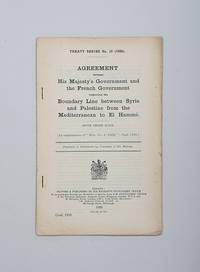
1923181603London: His Majesty's Stationery Office 1923 but 1924. Lines in the sand First trade edition one of 250 copies of the text of the Paulet-Newcombe Agreement including three maps delineating the newly agreed Palestine-Syrian border. The agreement was signed in March 1923 a few months before the Britain's Palestine mandate came into force. Whitehall was represented in the Anglo-French negotiations by Lieutenant-Colonel Stewart Francis Newcombe 1878-1956 a close wartime associate of Lawrence of Arabia who is cited frequently in Seven Pillars of Wisdom. Newcombe was commissioned into the Royal Engineers in 1898 and transferred into the Egyptian Army in 1901. Shortly before the outbreak of war he travelled to southern Palestine in the company of Lawrence and Leonard Woolley to complete a secret survey for the British government - "this initial encounter with Lawrence set up a lifelong friendship between the professional soldier and the young scholar-archaeologist. Newcombe's extraordinary exploits and courage coupled with an inexhaustible supply of energy made him a legend in the desert causing the Arabs to complain that 'Newcombe is like fire he burns friend and enemy'" ODNB. In 1935 he was one of the six pallbearers at Lawrence's funeral. According to the printer's slug the agreement was first published in July 1923 in the Parliamentary Papers series. Octavo pp. 16. With 3 folding colour maps. Text in English and French. Original printed self-wrappers. Wrappers and maps repaired with archival tape rear cover chipped: very good. Khalidi & Khadduri 1648. unknown
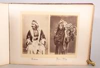
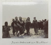
189257643<p>PHOTOGRAPHS 1890s INCLUDING SOME OF JEWISH COLONISTS</p><p>oblong folio album 28 x 27.5 cms. 22 thick card leaves on guards on the card sides are mounted 170 original sepia tinted photographs 9.5 x 12 cms. 4 photographs per 'page' except two 'pages' at the end with 3 photographs and the last 'page' blank all photographs neatly captioned in pen bound in contemporary half black morocco spine with gilt decorated raised bands black cloth on sides front cover boldly lettered at centre 'Palestine' and at foot "M. & A. W." and 1892 or 3 final numeral defaced cloth on fore edges of both boards damp stained with loss of the final numeral of the date see below front endpapers likewise damp stained at fore edges contents otherwise very good.</p><p>The damp damage to the fore-edge of the cloth has caused the loss of the gilt on the last numeral of the date but a trace remains of the top part of the impressed numeral and from that shape it must be either a 2 or a 3.<br />This album records a visit and tour through Palestine by two English speaking persons "M & A. W" that we have not been able to identify. The photographs obviously taken by one of the party record their progress guides local people villages bedouin encampments encountered buildings horses etc. One photograph on the first page clearly shows a member of the travelling party a fairly elderly woman about to travel on a mule-borne palanguin. Another of the party in a boat about to cross the Sea of Galilee appears to show two women. Places depicted include Sebastiych in Samaria Shumem modern Sulan of which there are many views Bethel Mount Tabor region Sea of Gallilee and the River Jordan Atlit Castle Tanturah modern Tantura Calvary Mar Saba monastery views along the road to Hebron and of the Russian hospice there etc. Very many of photographs show local people encountered along the way and three photographs at Tanturah show "Jewish colonists" there. Baron Rothschild owned land there and had in 1884 a Russian Jewish farmer establish a farm there and "In 1891 Baron Rothschild financed the development of a bottle factory in Tantura as he planned to use the fine sand on the shore to manufacture glass bottles for the fledgling wine industry . A building was constructed . dozens of workers were hired and three ships were purchased to transport raw material and bottles. But he abandoned the factory in 1895 after a string of failures" wikipedia. Presumably these colonists were attached to that enterprise. A number of photographs include Abraham Lyons their dragoman translator and guide the only person actually here identified by name. Lyons is recorded as a Jerusalem based dragoman in Baedeker's <em>Palestine and Syria Handbook for Travellers</em> 1867 and in "Letter from Jerusalem" in <em>The Rockland Co Journal</em> vol.xxxiii May 1883 "dragoman Lyons" is described as a "Christian Israelite".<br />The photographs are in good condition with only a few faded.</p> hardcover
1933LBEG60X1NJ1QLondon: His Majesty's Stationary Office 1933. Original publisher's printed wrappers. 4to in 16s. With two folding maps showing parts of the Palestine territory that had been surveyed in detail. Detailed report to the Mandates Commission of the League of Nations regarding the British controlled Mandate of Palestine. After the collapse of the Ottoman Empire after World War I the Empires territories in the Middle East were divided between Great-Britain and France with the exception of the newly created Kingdom of Saudi Arabia and ruled as mandates on behalf of the League of Nations. The Mandate of Palestine was one of the territories governed by Great-Britain on behalf of the League of Nations and the British government had to produce an annual report of the territorys government for the League of Nations. The first proper report was produced in 1924 and they were produced every year thereafter until 1938. The reports contain extensive information on the region at that specific period describing the economy politics judicial system public health technological works and religious matters. The growing unrest in the Arab population and its strife for independence which would lead to the 1936-1939 revolt against British rule is already clearly visible in the report.In very good condition. Binding slightly worn and with a few folds.l National voices in Jordan: the street and the state p. 247. His Majesty's Stationary Office, unknown
1940228911940. An early Zionist cigarette card photo album during the British Mandate period documenting Jewish paramilitary forces settlement defense athletics and infrastructure development in Mandatory Palestine likely produced in the 1930s-1940s as an educational and propaganda tool. The images illustrate the development of defense forces collective agricultural settlements and youth training movements that formed the institutional foundation of Jewish state building in the region.<br /> <br /> British Mandatory Palestine c. 1940s. 200 black-and-white silver gelatin photographic cigarette cards mounted in original printed album with Hebrew captions and descriptions. Folio. Original illustrated stiff wraps featuring a soldier in a sun helmet scanning the horizon rifle slung over his shoulder. A rare Zionist cigarette card photo album documenting the military security and athletic institutions of the Yishuv the Jewish community in pre-state Palestine during the British Mandate period. The album serves as both propaganda and educational material designed to instill national pride and discipline among the Jewish population particularly youth involved in the Haganah the Palmach and other proto-military defense organizations. The imagery and text emphasize the dual ethos of physical preparedness and self-defense alongside agricultural labor and nation-building. The album consists of photographic cigarette cards depicting key aspects of Zionist security forces settlement defense and sporting achievements in Mandate Palestine. The first sections focus on military training featuring members of the Jewish Settlement Police Notrim Jewish auxiliary police under the British and early paramilitary forces. Uniformed men in sun helmets keffiyehs or British-style caps are shown patrolling rural roads manning watchtowers practicing marksmanship and training in hand-to-hand combat. The inclusion of women in certain images suggests their role in auxiliary units foreshadowing the integration of women in the Israeli military. Several images capture women in agricultural labor construction and fishing industries highlighting their integral role in building and sustaining early Jewish settlements particularly within the kibbutz movement. Additionally photographs of women in aviation training including piloting gliders showcase early efforts to integrate them into technical and military fields.<br /> <br /> A later section transitions into the "Wall and Tower" Homa U'Migdal settlements-strategically built fortified agricultural outposts constructed overnight to establish a Jewish presence in contested areas. Photographs show men and women erecting wooden watchtowers carrying supplies and working cooperatively to secure land under hostile conditions. These images capture the pioneering spirit of the Yishuv where defense and agriculture were inseparable components of state-building. The final third of the album focuses on athletics reflecting the Zionist ideal of the "New Jew"-physically strong self-sufficient and ready to defend the homeland. Included are images of Jewish sports leagues fencing boxing wrestling weightlifting and track and field with a notable photograph of a female athlete wearing a "Ramah" Maccabi shirt symbolizing Jewish participation in international sports and the Maccabiah Games. The album also features aviation imagery including early Jewish pilots training in gliders an essential precursor to the formation of the Israeli Air Force.<br /> <br /> Covers show mild wear with minor foxing and wear to spine. Interior pages exhibit mild creasing to margins pages and photographs clean. Some cigarette cards are slightly lifting at the edges but all appear present. Overall very good condition. A visually rich artifact of Zionist history this cigarette card album offers rare photographic documentation of Jewish military organization settlement defense and athletic prowess during a crucial period leading to Israeli statehood. Complete or near-complete examples of such albums are scarce and highly sought after. unknown
Very Good Latin Extremely rare second edition of Quaresmus' work including four parts in two volumes, which is a a contribution to history, geography, archaeology, biblical and moral science of the East and Holy Land. First Edition is 1639, printed in Antwerp. This edition was edited by Father Cypriano da Treviso. First volume has one two-page map titled 'Chorographia Terræ Sanctæ Sev Terræ Promissionis Nova Descriptio' depicting a very attractive view of the Holy Lands, which is decorated ships heading to the Holy Land. Second volume has two maps, one plate, and two plans (All is folded and huge sizes). First map is one of the most attractive views of Extremely rare second edition of Quaresmus' work including four parts in two volumes, which is a contribution to history, geography, archaeology, biblical and moral science of the East and Holy Land. First Edition is 1639, printed in Antwerp. This edition was edited by Father Cypriano da Treviso. The first volume has one two-page map titled 'Chorographia Terræ Sanctæ Sev Terræ Promissionis Nova Descriptio' depicting a very attractive view of the Holy Lands, which is decorated ships heading to the Holy Land. The second volume has two maps, one plate, and two plans (All are folded and huge sizes). The first map is one of the most attractive views of Jerusalem titled 'Novæ Ierosolymæ et Locorvm Circvmiacentivm Accvrata Imago'. Other is depicting attractively 'Montis Calvariæ' [i.e. Calvary, or Golgotha] which was, according to the canonical Gospels, a site immediately outside Jerusalem's walls where Jesus was crucified, as well as Bethlehem and Resurrection Temple's plans. Quaresmio was a writer and Orientalist of the seventeenth century. His father was the noble Alberto Quaresmi and his mother Laura Papa. At an early age, he was enrolled among the Franciscan Observantines at Mantua. For many years he held the chairs of philosophy, theology, and canon law, and became successively guardian, custos, and minister of his province. His long apostolate in the East and the magnificent works he has left us have secured Quaresmius worldwide fame, especially among earlier historians, Biblical scholars, and Orientalists. On 3 March 1616, he went to Jerusalem, where he became Guardian and Vice-Commissary Apostolic of Aleppo in Syria (1616-8), and Superior and Commissary Apostolic of the East (1618-9). During this period he was twice imprisoned by the Turks. In 1620 he returned to Europe, but in 1625 was back in Jerusalem, whence the following year he addressed from the Holy Sepulchre an appeal to Philip IV of Spain, inviting him to reconquer the Holy Land, and at the same time dedicating to him his work, "Hierosolymæ afflictæ". Between 1616 and 1626 he wrote his classical work, "Elucidatio terræ Sanctæ", adjudged by the learned a monumental contribution to history, geography, archæology, Biblical and moral science. During 1627-9 he was at Aleppo as papal commissary and as vicar-patriarch for the Chaldeans and Maronites of Syria and Mesopotamia. In 1629 he went to Italy to render an account to the Holy See of the state of the Eastern Churches; he then returned to the East, but how long he remained is not known. Meanwhile, he journeyed through Egypt and Sinai, the Holy Land, Syria, Mesopotamia, Cyprus, Rodi, Constantinople, and a large part of Asia Minor; he also visited Germany, France, Belgium, and Holland. In 1637 he was a guardian of S. Angelo (Milan), wherein 1643 he completed his other great work on the Passion of Christ. Original 1/3 black leather bdg. Six raised bands to spine. Marbled endpapers. Gilt title on spine and volume numbers. Folio. (38 x 28 cm). In Latin. 2 volumes set: (xxviii, [8], 761 p.; 893 p., 6 engraved maps and plans (5 folded)).
VO046Leipzig, Baumgärtner (1810-1814) trois cahiers en un volume. 3 titres, 20+19+18 p. et 36 gravures pleine page. Exemplaire rare et propre, une douzaine de feuilles ont une rousseur claire a la marge inferieure. Long folio dans une reliure contemp. 1/3 veau, dos droit orne legerement use, tranches coloriees.
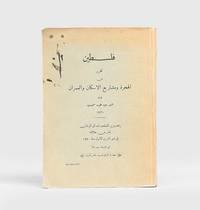
1930188559Jerusalem: Matba'at D r al-ayt m al-S r yah 1930. The Hope Simpson Report First Arabic edition of Sir John Hope Simpson's groundbreaking report with only two other copies traced at the American University of Beirut and the National Library of Israel. It was published in the same year as the English edition. After a successful career as a diplomat and politician Simpson 1868-1961 was sent to the British Mandate of Palestine subsequent to the 1929 riots to chair a British commission addressing Jewish land settlement and Zionist policies. The report discusses Palestine's natural conformation and climate the impact of Jewish land ownership on the economy and the resulting widespread unemployment among the Arab population which was a cause of unrest. It also addresses demographic changes and public health services including anti-malaria prophylaxis as well as irrigation projects the types of land and its ownership present in Palestine and legislation concerning Bedouin land rights. A pivotal observation is the economic imbalance between the Jewish settlers and the Arab population. The report concludes that "there is at the present time and with the present methods of Arab cultivation no margin of land available for agricultural settlement" and that "it is impossible to give. a reliable estimate of the number of families who could be accommodated in Palestine if the whole country were adequately developed". Quarto. Original blue wrappers wire-stitched as issued. Corners a little bumped spine creased front cover sunned with couple of ink drops and marks towards outer margin contents toned but clean: a very good copy. unknown
275 pages. Footnotes. "Geula Cohen [1925-2019] was a ranking member of the notorious Stern Gang in its fight against the British for a free Palestine (Israel). Her memoirs explode with the ferocious intensity of her terrorist faith, her inflexible idealism. An open and intimate portrait of a woman, and the conditions that drove her underground to embrace a philosophy of violence and terror." - dust jacket. "I have no doubt that [this book] will be a proud memorial to the daring fighters who offered their lives for the cause of Jewish redemption. It also attests to the supreme nobility of the soul of its writer." - David Ben-Gurion. Book clean, bright and unmarked with light wear. Moderate lean to spine. Soiling to back panel of dust jacket which is otherwise moderately worn and now preserved in archival-grade Brodart. A sound copy. Book
223, 16 (ads) pp. Index. "The problem of the Jews in Britain, and the power they wield in public affairs, is a matter of the most absorbing interest in these days when propaganda has clouded the issue and made it almost impossible for the ordinary man to see the subject in its true perspective. This book is a critical but strictly impartial analysis written by a well-known Fleet Street journalist who has studied the whole problem for a number of years in the light of events since the Great War." - from dust jacket. Unmarked with moderate wear to publisher's orange cloth. Binding intact. Small contemporary Buenos Aires bookseller's sticker inside front board. Above-average wear to dust jacket, now preserved in archival-grade Brodart. A sound copy. Singerman 494. Book
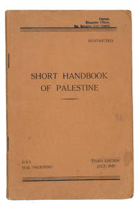
1947ABC_48432London: printed by the Printing and Stationery Services M. E. F. 1947. Original printed orange/brown paper wrappers. 8vo. With one folding map and four folding tables. Rare military guide to Palestine issued by the British military intelligence for use during the British Mandate. The present copy was stamped by the 1st Batallion Irish guards which was stationed in Palestine after the Second World War to perform internal security duties there. The work offers a description of the history government population topography water resources railways climate health and trade of the country. Also included are a folding map of the Palestinian railways and four folding tables with graphs about the weather. The first edition of the handbook was issued in April 1944. The present copy is the third and final edition which was revised and brought up-to-date with the situation in May 1947. As the handbook was "restricted" and therefore likely published in limited numbers any edition of it is very rare. We have only been able to find one other copy in sales records of the past hundred years and WorldCat only records two copies in libraries.With a blue stamp at the head of the front wrapper "Captain education officer 1st Battalion Irish Guards" and again at the foot of the first page. The edges and corners of the wrappers are somewhat scuffed. The leaves are slighty creased throughout with brown stains on pp. 7-13 and 31 slightly affecting the text. Otherwise in good condition.l Jisc 1 copy; WorldCat 1114861975 2 copies. printed by the Printing and Stationery Services, M. E. F., unknown