APRES de MANNEVILLETTE (Jean-Baptiste-Nicolas-Denis d').Livre Rare Book
33 résultats
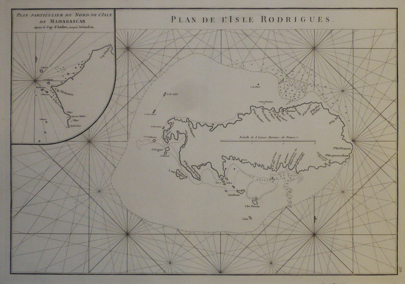
1775LBW-1276[1775-1781]. 331 x 482 mm.
1771LBW-8276[Paris, 1771-1786]. 235 x 185 mm.
1775LBW-6789Dépôt-Général de la Marine, [1775-1781]. 490 x 331 mm.
1771LBW-8293[Paris, 1771-1786]. 235 x 185 mm.
1771LBW-4331[Paris, 1771-1786]. 234 x 181 mm.
1771LBW-8279[Paris, 1771-1786]. 232 x 179 mm.
1775LBW-1963[1775-1781]. 334 x 495 mm.
1775LBW-1956[1775-1781]. 488 x 667 mm.
1780LBW-3427[circa 1780]. 285 x 405 mm.
1775LBW-1966[1775-1781]. 334 x 484 mm.
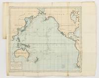
1790143934Paris: F. Dufart 1790. Very Good. Paris F. Dufart circa 1790. A hand-coloured engraved map printed surface 378× 415 mm sheet size approximately 420 × 540 mm. 'Gravée par Tardieu l'Ainé . Dessiné par Poirson . Ecrit par Beaublé'. Original folds as issued; some minor uneven tanning; in very good condition. An uncommon chart of the Pacific Ocean and Australia showing magnetic variation and dip drawing on observations made in the course of Pacific voyages after 1775 most notably Cook's third voyage. It is most likely from a duodecimo edition of Buffon's 'Histoire naturelle générale et particulière' around the end of the eighteenth century 'PL. III. Tome XVI' and 'Page 58' are printed in the top margin. It is based on a larger chart in four sheets attributed to Jean-Charles de Borda. The engraver Tardieu is one of half a dozen members of the family working as engravers at the period one of whom P.A.F. Tardieu would engrave the charts published in the official account of the Baudin voyage. F. Dufart unknown
17502180[], [], [1750 ca]. In-4 de 8 pp., cartonnage moderne.
177744433Amsterdam, et se trouve à Paris, chez Pissot, Nyon, 1777. In-8 de (4)-XIX-(1)-546 pp., veau havane marbré, dos orné à nerfs, pièce de titre en maroquin rouge, tranches rouges (reliure de l'époque).
178515723Genève, Paris, [], 1785. In-8 de 14-(2)-292 pp., veau fauve, dos lisse orné, pièce de titre en maroquin (reliure de l'époque).
179750776A Geneve Biblioth. Britannique 1797. 8vo. Contemp. marbled boards. Paperlabel with handwritten volume- title on spine. Boards rubbed. In: "Bibliotheque Britannique" Tome cinquieme. Sciences et Arts. A name cut from titlepage no loss of letters. Entire volume offered. 392 pp. 4 folded tables a. 3 folded engraved plates. A faint dampstain to foot of titlepage otherwise clean printed on good paper. Rumford's paper: pp. 97-200 a. 1 engraved folded plate. <br/><br/><em>First printing of the founding paper on Oceanography describing the experiments leading to the discovery of the convection currents in the sea. Cold water at depth in the tropics implies a meriodinal circulation transporting deep water from the polar regions towards the equator. Water cooled at the surface in high latitudes gets denser and hence descends. Parkinson "Breakthroughs" 1797.The volume also contains the first translation of any part into French of JAMES HUTTON "Theory of the Earth &c. Théorie de la Terre avec des preuves & des éclaircissemens; en guatre parties. 1.-2. Extrait.". Pp. 53-73 a. pp. 262-273. </em> hardcover
179750776A Geneve, Biblioth. Britannique, 1797. 8vo. Contemp. marbled boards. Paperlabel with handwritten volume- title on spine. Boards rubbed. In: ""Bibliotheque Britannique"", Tome cinquieme. Sciences et Arts. A name cut from titlepage, no loss of letters. Entire volume offered. 392 pp., 4 folded tables a. 3 folded engraved plates. A faint dampstain to foot of titlepage, otherwise clean, printed on good paper. Rumford's paper: pp. 97-200 a. 1 engraved folded plate.
178542677Paris, Hôtel de Thou, 1785. Ensemble de 18 vol. in-8 et 3 vol. d'atlas in-4 de 52-67-88 planches, demi-veau havane, dos lisse orné de filets dorés, pièces de titre et de tomaison en veau vert (reliure de l'époque).
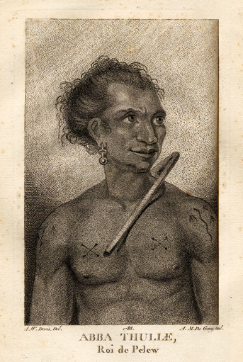
178814520Paris, Le Jay et Maradan, 1788 ; 2 tomes in-8 ; demi-chagrin noisette (reliure moderne) ; (4), 282 pp., portrait du capitaine Henri Wilson en frontispice, gravé par Mme Massard d'après I. Russell, grande carte géographique dépliante, 7 planches gravées dont 6 dépliantes ; (4), 274 pp., (3) ff. Errata et Approbation, 8 planches gravées dont 6 dépliantes, soit 17 planches au total ; vocabulaire de la langue Pelew pp. 251-267 du tome II.
180043698Paris, H.-J. Jansen, 1800 (an VIII). 2 vol. in-4 de XVI-442 pp. et 332-113 pp. pour les deux volumes de texte, et 1 atlas in-folio de 1 titre, 43 planches gravées hors texte et 1 grande carte dépliante, demi-basane verte, dos lisses ornés, entièrement non rogné, couvertures muettes conservées, l'atlas est en demi-veau à coins.
1755ABC_474521755. Manuscript of 24 pages 6 printed maps on cardboard. This wonderful logbook details the journey of a French captain from Manila to the Maluku Islands in todays Indonesia. The journey took place during the months of March to May of 1755. The captain of the ship recounted with great detail the events of every day of the journey with detailed daily accounts of the weather winds manoeuvres of the ship its departures anchorages and precise coordinates at every point of the journey. The captain furthermore had a keen eye for the geographical and nautical details along the journey. He recounted the exact locations of for example sandbanks and bays where ships and their crews can take provisions and fresh water. The accounts are detailed and captivating: "After our boats were back on board we set sail . in the afternoon to moor under the old Portuguese fort on the Solor island Indonesia the winds for the tide were fresh at 1:34 a.m. . sand and gravel and then I went back to mooring. The pavilion of the fort . the village is under the said fort at 3 cables from us .". The captain goes on to describe the geographical features of the islands as well as other places en route with great detail. Curiously we find inscriptions in Spanish and the names of one don Phelipe Qui who describes himself as el piloto and one Padre Don Estevan de Melo. The latter might be identical with Don Estevan Roxas y Melo a native of Lima Peru and secretary to the Archbishop of Manila Rodriguez since 1736. Roxas y Melo was part of the 1751 reconstruction of the Cathedral of Manila working under the auspice of the Italian architect Juan de Uguccioni.The logbook comes with six printed maps partly illustrating the journey of the captain pasted on contemporary cardboard. They depict the Bay of Sulavesi with the city of Bantang Pitcairn the coast of New Guinea the coast of Queensland the Santa Cruz Islands in the present-day Solomon Islands and Alejandro Selkirk Island. The plates stem from the French translation of James Hawkesworths An Account of the Voyages Hawkesworth Relation des voyages entrepris par ordre de sa Majesté Britannique actuellement regnante; pour faire des découvertes dans l'hemisphère meridional Paris 1774.Some holes on the first sheet not affecting the text. Small water damage some slighlty affecting the text. Remnants of seals on last page. Otherwise in good condition. unknown
1782106474BBParis, Pissot, pere & fils et Laporte, 1782. 8°. X, 508 S. mit gestoch. gefalt. Frontispiz u. 1 gefalt. gestoch. Karte. Kalbslederband der Zeit mit goldgepr. Rückenschild und floraler Rückenvergoldung. [4 Warenabbildungen]
1785WOC-2668Ou Voyage à l'Océan Pacifique, Ordonné par le Roi d'Angleterre, Pour faire des Découvertes dans l'Hémisphère Nord, pour déterminer la position & l'étendue de la Côte Ouest de l'Amérique Septentrionale, sa distance de l'Asie, & résoudre la question du Passage au Nord. Exécuté sous la direction des Capitaines COOK, CLERKE & GORE, sur les Vaisseaux la Résolution & la Découverte, en 1776, 1777, 1778, 1779 & 1780. Traduit de l'Anglois, par M. D*********. Tome Second. Paris, Hôtel de Thou, rue des Poitevins, 1785. Fort in-8 (22x5,5x13,5cm) plein cartonnage d'époque, et une étiquette imprimée sur le plat supérieur du nom d'une ville en Suisse (Hellen à Yverdon). 512pp.
1785WOC-2669Ou Voyage à l'Océan Pacifique, Ordonné par le Roi d'Angleterre, Pour faire des Découvertes dans l'Hémisphère Nord, pour déterminer la position & l'étendue de la Côte Ouest de l'Amérique Septentrionale, sa distance de l'Asie, & résoudre la question du Passage au Nord. Exécuté sous la direction des Capitaines COOK, CLERKE & GORE, sur les Vaisseaux la Résolution & la Découverte, en 1776, 1777, 1778, 1779 & 1780. Traduit de l'Anglois, par M. D*********. Tome Troisième. Paris, Hôtel de Thou, rue des Poitevins, 1785. Fort in-8 (22x5,5x13,5cm) plein cartonnage d'époque, et une étiquette imprimée sur le plat supérieur du nom d'une ville en Suisse (Hellen à Yverdon). 592pp.
178822927Londres J.-P. Lyton 1788 -in-12 plein-veau 4 Tomes reliés en 2 volumes, reliure plein veau havane marbré in-douze (binding full calfskin in-12)(17,3 x 10 cm), RELIURE D'EPOQUE, dos long (spine without raised bands), décoré "or"et à froid (gilt and blind stamping decoration), titre frappé "or" avec un filet "or" en encadrement, tomaison frappée "or", pièce de tomaison sur fond maroquin vert olive avec un filet "or" en encadrement, entre nerfs à fleuron "or" dans un encadrement d'un filet "or" avec rinceaux "or" aux angles, roulette "or" en place des nerfs avec un filet "or" de part et d'autre et en tête et en pied, plats marbrés décorés à froid d'un filet à froid en encadrement, roulette "or" sur les coupes avec manques de dorure, toutes tranches lisses rouges, marque page en tissus, sans illustrations (no illustration) excepté une vignette au titre (différente à chaque fois) gravée sur bois en noir, en noir, (319) + (324) + (319) + (308) pages, 1788 Londres : J.-P. Lyton Editeur,
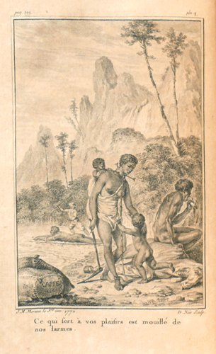
17730034671773 Amsterdam, et se trouve à Paris, Chez Merlin, 1773. Deux volumes in-8 (134 X 205 mm) veau fauve marbré, encadrement de filet à froid sur les plats, dos cinq nerfs, caissons dorés avec fleuron central, large dentelle en queue et tête, coupes et coiffes ornées, pièces de titre et de tomaison maroquin rouge, tranches rouges (reliure de l'époque). Tome I : (1) f. blanc, faux-titre, frontispice, titre, 328 pages, 3 planches et 4 tableaux dépliants, (1) f. blanc ; Tome II : faux-titre, titre, 278 pages, 2 planches, (1) f. blanc. Notice ancienne collée sur le premier contreplat du tome I. Les planches de Moreau sont brunies.