Fornasier, Jochen und Böttger, Burkhard (Hrsg.)Antiquariat.de

242 résultats
200270303gsMainz am Rhein, von Zabern, 2002. fester Pappband, mit farbigem Deckelphoto, ca. DinA 4, IV+126 Seiten, 123 Farbfotos, 11 Schwarzweiß- und 17 Strichabbildungen, Farbfotos auf den Einbandinnenseiten/Vorsatzblatt, Einband mit minimalen Gebrauchsspuren, sehr gut erhalten / sehr guter Zustand [4 Warenabbildungen]
Very Good English Paperback. Pbo. Demy 8vo. (21 x 14 cm). In English. [80] p., color ills. Bosphorus thru the eyes of a tour guide.
192026617Paris Flammarion 1920 In-12 283 pp, boone reliure, dos décoré, menues traces de frottement
192030428Paris Flammarion 1920 In-12 284 pp
New Turkish Original bdg. HC. Large 8vo. (23 x 23 cm). In Turkish. 167 p., color and b/w ills. Halic?: Du?nden bugu?ne yedi tepenin koynunda uyuyan bu?yu?lu? cennet.
New English Original bdg. HC. 4to. (33 x 24 cm). In Turkish. 269, [2] p. Color and b/w ills. Historic gangboards (ferry piers) of Istanbul. Iskeleler sehri Istanbul. ISTANBUL Constantinople Ottoman sociel history Stemship Ship Transportation The Bosphorus The Golden Horn Haliç Bogaziçi.
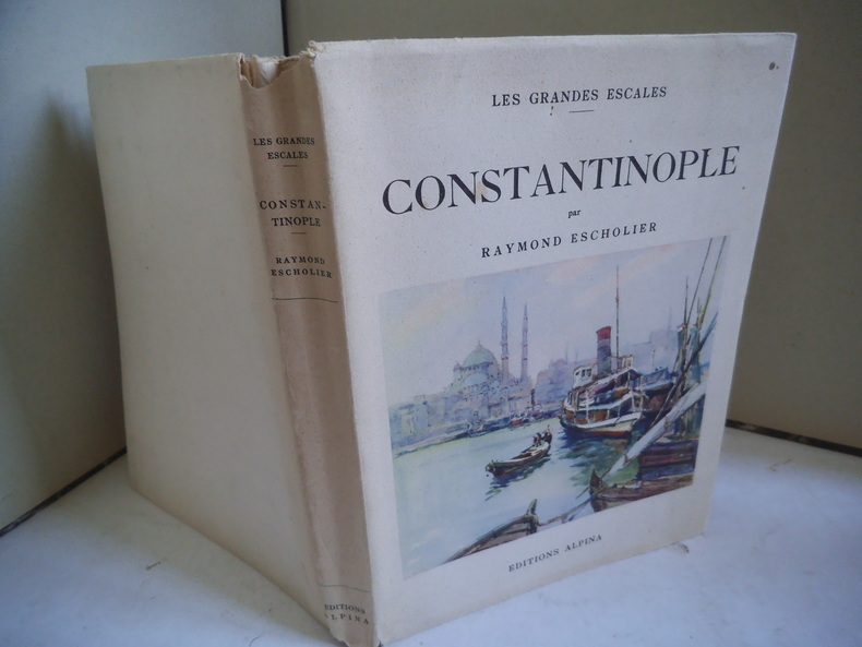
12921In 8 carré brioché, jaquette illustrée en couleurs. Faux-titre, titre, 152 pages, illustrations en couleurs hors-texte plus la couverture de Nicolas MARKOVITCH. Photos dans le texte et à pleine page. Edition Alpine Les grandes escales septembre 1935. Très bon état
Very Good French Original pictorial grey cloth bdg. Cr. 8vo. (20 x 12,5 cm). Edition in French. 630, [2] p, 300 unnumbered illustrations, 6 folded maps and plans. First French edition of this comprehensive and attractive Istanbul guide written by Mamboury, who is a Swiss scholar renowned for his works on the historic structures in Turkish cities, particularly on Byzantine art and architecture in Istanbul.
Very Good English Original b/w portolan chart. Folded. A little foxing and some pencil markings and notes in Ottoman script in its period. Oblong double elephant folio. (70 x 102 cm). In English. Bosphorus to Kerempeh from the Russian survey of 1834 with additions and corrections by Commander W. J. L. Wharton., R. N. 1872-80. It's written 'London published according to Act of Parliament at the Hydrographic Office of the Admiralty Jare. 16th 1854. Also shows Killa Bay (Shile Bay) from a survey by Lieut. Comm. W. R. Pristen and the midshipmen of H. M. S. Royal Sovereign, 1920. Topography partly from a Turkish map. Up side of map, engraved a view from sea of entrance of the Bosphorus, Rumili (sic. Rumeli) Lighthouse and environment with several hills. And also shows Amastra (Ancient Amastris) from Russian surveys, 1834-41; Kosku Bay from a surbey by Capt. Spratt R. N. 1854; and Sungul Bay (Zonguldak) from the Heraclee Companys plans to 1915. A rare navigation chart.
Fine English Paperback. Pbo. 4to. (30 x 21 cm). In English and Turkish. 155 p., b/w ills. Photographer Ali Sami, 1866-1936.= Fotografçi Ali Sami, 1866-1936. "Ali Sami (Aközer) is born in Rusçuk in 1866, and moves to Istanbul. Because his family is registered in the Beylerbeyi quarter of Üsküdar, Ali Sami is also called Üsküdarli Ali Sami. He graduates from the Mühendishane-i Berri-i Hümayun in 1866 and becomes a teacher of painting and photography at the school. He is employed in the Ottoman army, and he is also a teacher of phography at the palace and for many years gives lessons to Prince Burhaneddin Efendi. In 1889 he becomes an aide to Abdülhamid II. As a military photographer, he is assigned by Abdülhamid II to accompany German Emperor Wilhelm II during his visit to the Ottoman Empire when he travels from Istanbul to Jerusalem in 1898, and presents an album of this journey to the sultan. After the constitutional monarchy is proclaimed, he becomes a painting teacher at Trabzon High School, and passes away in 1936 in Istanbul". (Source: From Konstantiniyye to Istanbul: Photographs of the Anatolian shore of the Bosphorus from the mid XIXth century to XXth century). Contents: - The World Discovers Photography - Turkish Art and the Effect of the Industrial Revolution on the Ottoman Empire - Photography in the Ottoman Empire - The Imperial School of Engineers - Ali Sami Bey - Album - Captions to Photographs.
New Turkish Original cloth bdg. In special slip-case. 4to. (29 x 25 cm). In Turkish. 369, [1] p., color and b/w ills. Treasury land from Akintiburnu to Bebek Garden that was bestowed upon Janissary Hasan Halife by Sultan Murad IV (1623-1640), was transferred to national treasury following a rebellion in 1631-1632 in the reign of Sultan Mehmed IV (1648-1687). In the reign of Sultan Ahmed III (1703-1730), treasury land from Hasan Halife Garden to Kayalar Village, was sold by Grand Vizier Damad Ibrahim Pasha in 1724/25. Grand Vizier Izzet Mehmed Pasha, who has a share in the said lands, built a pavilion just for the Sultan. Sultan Selim III (1789-1807) set foot on Izzetabad Pavilion for the first time upon the invitation of GRAND Vizier Izzet Mehmed Pasha, but later he frequently came to the Pavilion for pleasure and entertaining activities. After a fire on May 15th, 1798; Izzetabad Pavilion was burnt down. And Grand Vizier Izzet Mehmed Pasha died in Manisa on September 18th, 1812. Treasury land from Akintiburnu to Bebek Garden that was bestowed upon Janissary Hasan Halife by Sultan Murad IV (1623-1640), was transferred to national treasury following a rebellion in 1631-1632 in the reign of Sultan Mehmed IV (1648-1687). The pavilion was rebuilt and redecorated by Chief Architect Mustafa and Hayrullah Efendi from Sehremini, between the years 1800-1804, and the palace was used by Sultan Selim III and Mahmud II (1808-1839). When the Bayraktar Group bought Izzetâbâd Pavilion, there was nothing more than relics of the basement. Its construction and renovation was completed in 1999. Thanks to the Bayraktar Group, Istanbul and Turkey have regained a precious heritage from the period of Selim III. After four years, in 2003, we started out to initiate the research which would unearth the mysterious history of Izzetâbâd Pavilion and Akintiburnu, together with Dear Emine Çigdem Tugay and Dear Mehmet Selim Tugay. In the corridors of the history of Akintiburnu, tracing back to nearly 2 thousand years ago, we started to discover the sophisticated and colorful history of Izzetâbâd Pavilion which witnessed great joys as well as torments and conspiracies to date. As a result, the book of Izzetâbâd Pavilion, Time Flies Away from Akintiburnu was published to reveal the history of Izzetâbâd Pavilion and Akintiburnu in light of historical documents. Today, we have this precious work of art written by Dear Emine Çigdem Tugay and Dear Mehmet Selim Tugay, and which gained further value thanks to the highly professional design by Dear Joelle Imamoglu.
Very Good English Paperback. Pbo. Roy. 8vo. (23 x 16 cm). In Turkish. 12, [10] p. B/w plates and maps. [=The Yali (Sea side mansion) of Sadullah Pasha (An Eighteenth century house on the Bosphorus)]. Sa'dullah Pasa yalisi.
Very Good Very Good English Paperback. Pbo. Dust wrapper. Roy. 8vo. (24 x 17 cm). In English and Turkish. 80 p., color ills. The 'Yali' (Sea-side mansion) of Sa'dullah Pasa (An eighteenth century house on the Bosphorus).= Sa'dullah Pasa Yalisi.
New English Original bdg. HC. Roy. 8vo. (24 x 17 cm). In English. 125 p., color ills. In God's House. 150 years of the Union Church of Istanbul in the Dutch Chapel.
Very Good Turkish Modern cloth bdg. 4to. (30 x 24 cm). In Turkish. 27 p. text; 21 numerous map feuilles in Ottoman script and modern Turkish. 19. asirda Istanbul haritasi. Ekrem Hakki Ayverdi was raised at a time in which Istanbul was undergoing its late Ottoman-early Republican period. Apart from his persona as an engineer-architect, restorer, and architectural historian, he was a collector passionately dedicated to Ottoman art. Undertaking the construction of different public buildings in Istanbul, Bursa and Edirne, as well as the restoration of many architectural works, Ayverdi not only brought together the most select and refined works of Ottoman art, which had begun to lose its prestige amidst the changing values of high culture in the time he lived, but he also paid particular attention to their conservation and preservation. Ayverdi's two seminal corpuses that study Ottoman architecture from its early days until the end of the Mehmed II era, as well as its examples in Roumelia, continue to maintain their place as the most important reference books for those working in this field. This is a detailed research on a 19th century map of Istanbul city.
1892013598Hachette, Paris 1892. 4ème Edition Hartkarton/Halbleinen Gut
New English Paperback. Pbo. Roy. 8vo. (24 x 17 cm). In English. 279 p. Twixt Pera and Therapia: The Constantinople diaries of Lady Layard. ISTANBUL Constantinople Memoirs Diplomacy Diplomat Socisl history Late period of Ottoman State Pera Travel Lady Layard, (1843-1912).
New New English Original bdg. Dust wrapper. 4to. (30 x 25 cm). In Turkish. 528 p., b/w ills. Osmanli belgelerinde Beykoz. Beykoz (Beicos) based on the Ottoman archival documents. A very heavy volume.
New English Original bdg. HC. Oblong large folio. (31 x 45 cm). In English and Turkish. [198] p., color maps, 4 maps in end-pocket. Istanbul PTT Museum Collections map catalog.= Istanbul PTT Müzesi Koleksiyonlari harita katalogu. Prep. by Kenan Bozgeyik, Selahattin Ekinci, Makbule Akyol. 3000 copies were printed. Contents: Catalogue of maps, sketchs and graphics.; Maps: Ottoman era: Turkish (Old script), Foreign languuage.; Turkish Republic era: Postal maps, road maps, maps of medical department, maps of civilian administration.; Plans and schemas.; Statistical maps.; Graphics.; Military maps: Anatolia, Rumelia, Outside of Turkey.; Additional.; Today PTT [Turkish Post Office].
New English Paperback. 4to. (28 x 24 cm). In English and Turkish. 360 p., color ills. The lure of the East: British orientalist painting.= Dogu'nun cazibesi: Britanya oryantalist resmi. [Exhibition catalogue]. This exhibition focused on the paintings made by British artists of the 'Orient', primarily during the nineteenth century. In this context the term 'Orient', to Western Europeans, meant those parts of the eastern Mediterranean world which could be accessed relatively easily such as Egypt, Palestine and Turkey, particularly after the development of steamboat and rail travel in the 1830s. In these places, predominantly Muslim and at least nominally under the control of the Ottoman Empire, British artists, such as David Roberts, David Wilkie, William Holman Hunt, John Frederick Lewis and Frederic Leighton, sought to develop imagery which captured what they believed to be characteristic of the people, cities and landscapes of the region. In the 1970s the Palestinian-American academic Edward Said published his treatise on Orientalism, initiating a global debate over Western representations of the Middle East. For many, such representations now appeared to be a sequence of fictions, serving the West's desire for superiority and control over the East. The argument for and against Said's Orientalism has continued for thirty years. Its resonance for an exhibition such as this one, however, is as strong as ever given that, by the 1920s (the end of the period covered by this exhibition), Britain was in direct control of much of the newly abolished Ottoman Empire, including Egypt, Palestine and Iraq. As Said argued, these images cannot be viewed in isolation from their wider political and cultural context. Keeping the debates around Orientalism in mind, "The Lure of the East" focuses on the range of pictorial options open to British artists, within five major themes: portraits, genre, religious and domestic subjects and landscape. British painters came to the Middle East from a culture steeped in technical and compositional artistic traditions. Such traditions were not easily unlearned, despite the apparent difference of the people and places the artists encountered on their travels. Given this, British Orientalist painters found many challenges in attempting to represent the Middle East, but they also found inspiration and, more importantly, the freedom to rework, reinvent and even discard those conventions that defined picture-making in Britain.
New Turkish Paperback. Pbo. Roy. 8vo. (24 x 17 cm). In Turkish. 460 p., ills. Byzantion'dan Constantinopolis'e Istanbul kusatmalari. Istanbul Research Institute presents a collection of papers in its new book. Although it does not discuss each siege that the city has encountered throughout its history of nearly two millennia, Byzantion'dan Constantinopolis'e Istanbul Kusatmalari presents a full view -panopticon- of the ones that sources bring to the forefront. It is a collection of works selected from current literature that takes into consideration the diversity of ancient sources, epigraphical documents, and numismatic finds which have gained more prominence in Ancient and Medieval studies. The book contains research essays written in Turkish and English which not only focus on the forces that have besieged Istanbul (ever since its foundation, the city has been sieged first by its closest neighbors, the Thracians, and later the Hellenes, the Macedonians, Hellenistic kingdoms, the Romans, the Avars, the Sassanids, the Arabs, the Bulgars, the Rus, the Crusaders, and the Ottomans), but also draw attention to political rivalries, sieges triggered by conflicts that resulted in civil wars, and the capital's defense elements.
New New English Original bdg. Dust wrapper. In publisher's special slip-case. 4to. (30 x 24 cm). In Turkish. 401, [17] p., color and b/w ills. Büyük Mecidiye Camii ve Ortaköy. A comprehensive study on Great Mecidiye Mosque and Ortaköy district of Istanbul, Constantinople published for restoration of 'Büyük Mecidiye Mosque'.
New English Original bdg. In publisher's special box. Folio. (33 x 29 cm). In English. 2 volumes set: (240 p., 5 unnumbered folded plates on pages; Second volume is a hard-case including two reprint panoramas and one reprint map: First panorama is a huge hand-coloured drawing shows Ottoman Palace across Sarayburnu; size 28x336 cm; Second panorama is a huge hand-coloured drawing shows Ottoman Palace across Sarayburnu again which is indicating Palace from a different angle; size 28x196 cm; and one map: 'Carta ufwer Orienten Med de Darom kring Grantzande Lander... (Turkey and its around map printed originally in early 18th century), descriptive text surrounding the map, size 65x85 cm. Cornelius Loos in the Ottoman world: Drawings for the King of Sweden, 1710-1711. [with] Panoramas & map [book]. Prep. by Lâle Uluç, David Jones, Klas Kronberg, Ersu Pekin. 2 volumes. [BOXED]. Cornelius Loos was one of the young military officers who followed Karl XII to the Ottoman Empire in 1709. From the royal headquarters in what is at present the republic of Moldova, Loos was sent to Istanbul on the King's orders in 1710. From there his journey was pursued by boat over the Mediterranean to Egypt and he returned by land through Jerusalem, Damascus, Aleppo, Konya and Izmir. Loos' mission was to make drawings of the "rarities and monuments" that he would encounter on his journey. Out of the drawings that have survived until today, one is from Palmyra, two from Rhodes and Bodrum and around forty aquarelle tush drawings from Istanbul. It is possible that part of the original drawings were destroyed in the "Skirmish at Bender" in 1713, while other works, due to various reasons, disappeared on their way to Sweden. The conserved drawings are kept at the Swedish National Museum and were exhibited there in 1985. (See catalogue titled "Cornelius Loos. Teckningar från en expedition till Främre Orienten 1719-1711", Stockholm, Nationalmuseum, 1985). The drawings represent a unique record of the urban landscape and the monuments in Istanbul in the early 18th century. The collection includes three great panoramas of the city seen from the Topkapi palace to the upper part of the Golden Horn. To the Loos paintings can be added the great Mecca painting brought to Sweden by Mikael Eneman and kept in the Uppsala University Library, and a small group of oil paintings brought back by Loos' travel companion Conrad Sparre, which are also kept in the art collection of Uppsala University. In addition there are travel accounts and correspondence from these journeys. (From the 'SRII's official site, Karin Adahl's project). "In January 1710 the Swedish king Charles XII, in exile in the Ottoman Empire, sent three of his officers on a journey from the royal camp near Bender in Moldova to travel to Constantinople and from there along the Eastern Mediterranean to Egypt. Their mission was 'to view the there existing rarities and monuments, to draw and to measure'. Cornelius Loos, one of the young officers, returned to his king in 1711 with more than 250 drawings. Only forty-nine, kept under the king's bed, survived a skirmish in the camp in 1713, the so called 'kalabalik' at Bender. King Charles had a vision to publish an encyclopaedic work about the Near East, a dream that was lost in the fire in the camp. The drawings were brought to Sweden when the king returned from the Ottoman Empire in 1714. He died in battle in Norway in 1718. Loos' drawings are unique documents of Constanttinople in the early 18th century, with large scale, detailed panoramas, important prospects of the interior of the Hagia Sophia and views from the Ottoman city. A big map is accompanied by minor drawings from the Black Sea, the Eastern Mediterranean and Egypt, as well as a spectacular set of water-colours of head dresses from the Ottoman world. The Loos collection of drawings is today kept in the National Museum in Stockholm.". Texts by Göran Baarnhielm, Ulla Ehrensvard, Nurhan Atasoy, Günsel Renda, Bo Lundstörm
New English Paperback. Small 4to. (25 x 21 cm). In French and Turkish. 267, [3] p., color and b/w ills. Entre trois mers: Cartographie Ottomane et Française des Dardanelles et du Bosphore.= Üç denizin arasinda: Osmanli ve Fransiz Bogaz haritalari. [Exhibition catalogue]. Curated by Pascal Lebouteiller. Articles by Jean-Louis Bacque-Grammont, Faruk Bilici, A. M. Celâl Sengör, George Tolias, Catherine Hofmann, Emmanuelle Vagnon et alli. Between three seas: Ottoman and French Cartography from the Dardanelles to the Bosphorus (17th - 19th centuries). The exhibition, "Between Three Seas: Ottoman and French Cartography from then Dardanelles to the Bosphorus (17th ¿ 19th Centuries)" is a collaboration between Arkas Art Center and French Institute for Anatolian Studies. Included in the exhibition are maps of the Dardanelles and the Bosphorus that are lent by the French National Library and French National Archives for the first time and important maps borrowed from archives and collections in Turkey. The exhibition sheds light on the close relationship between the Ottoman and French states over centuries through showing transportation routes by sea, military and armed force settlements, surrounding rural and agricultural areas, geographic and cultural boundaries. The maps of Turkish and French origin offer a comparative perspective on the Bosphorus and the Dardanelles as well as on Ottoman and French cartography. The exhibition also includes pilot charts, military maps, sketches, calculations, drafts and scribbles that reveal the production process of the maps.
Fine English Paperback. Small 4to. (25 x 21 cm). In French and Turkish. 267, [3] p., color and b/w ills. Entre trois mers: Cartographie Ottomane et Française des Dardanelles et du Bosphore.= Üç denizin arasinda: Osmanli ve Fransiz Bogaz haritalari. [Exhibition catalogue]. Curated by Pascal Lebouteiller. Articles by Jean-Louis Bacque-Grammont, Faruk Bilici, A. M. Celâl Sengör, George Tolias, Catherine Hofmann, Emmanuelle Vagnon et alli. Between three seas: Ottoman and French Cartography from the Dardanelles to the Bosphorus (17th - 19th centuries). The exhibition, "Between Three Seas: Ottoman and French Cartography from then Dardanelles to the Bosphorus (17th ¿ 19th Centuries)" is a collaboration between Arkas Art Center and French Institute for Anatolian Studies. Included in the exhibition are maps of the Dardanelles and the Bosphorus that are lent by the French National Library and French National Archives for the first time and important maps borrowed from archives and collections in Turkey. The exhibition sheds light on the close relationship between the Ottoman and French states over centuries through showing transportation routes by sea, military and armed force settlements, surrounding rural and agricultural areas, geographic and cultural boundaries. The maps of Turkish and French origin offer a comparative perspective on the Bosphorus and the Dardanelles as well as on Ottoman and French cartography. The exhibition also includes pilot charts, military maps, sketches, calculations, drafts and scribbles that reveal the production process of the maps.