CAMOCIO (Giovanni Francesco).Livre Rare Book
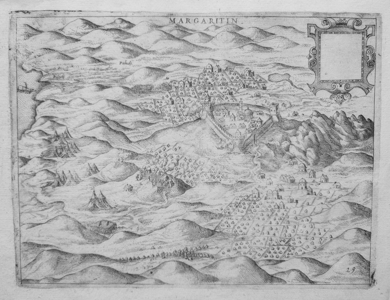
[MARGARITI] Margaritin.
1572LBW-1446[Venise, 1572]. 168 x 222 mm.
Librairie Le Bail · Paris, France600,00 €
18 204 résultats
Very Good German Original color map on cloth. A little foxing on cloth. Very good. Folded. Oblong folio. (45 x 51 cm). In German. [MAP of WEST GREECE] L.15. Philiataes (Corfu). Jonisches Meer. Scale: 1/300.000. A sheet of the collection of 'The general map of Central Europe'. appeared in the years between 1873-1876 with the work of Joseph Ritter von Scheda, (1815-1888) who was a general, geographer and cartographer.
Very Good German Original color map on cloth. Chipped on folded places. Oblong atlas folio. (46 x 52 cm). Toponyms in German. [MAP of WEST WALLACHIA - CRAIOVA] N.10. Kraiova. A sheet of the collection of 'The general map of Central Europe'. appeared in the years between 1873-1876 with the work of Joseph Ritter von Scheda, (1815-1888) who was a general, geographer and cartographer.
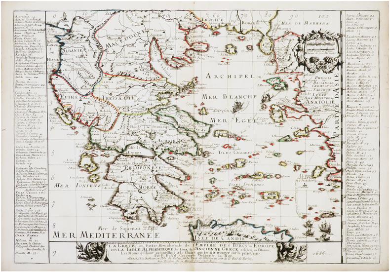
Very Good French Original decorated map. Hand-coloured. Oblong elephant folio. (54 x 76 cm). In French. Shows Greece, Archipelago, Isle de Candie, Asia Minor (Western side), and East Mediterranean. Delisle od de l'Isle was a French cartographer known for his popular and accurate maps of Europe and the newly explored Americas. At 27, Delisle was admitted into the French Académie Royale des Sciences, an institution financed by the French state. After that date, he signed his maps with the title of "Géographe de l'Académie". Five years later, he moved to the Quai de l'Horloge in Paris, a true publishing hub where his business prospered. Delisle's progress culminated in 1718 when he received the title of Premier Géographe du Roi. He was appointed to teach geography to the Dauphin, King Louis XIV's son, a task for which he received a salary. Again, his father's reputation as a man of science probably helped the younger Delisle. Historian Mary Sponberg Pedley says, 'once authority was established, a geographer's name might retain enough value to support two or three generations of mapmakers'. Delisle's case, it could be said that his accomplishments surpassed his father's. Up to that point, he had drawn maps not only of European countries, such as Italy, Spain, Germany, Great Britain, Poland, and regions such as the Duchy of Burgundy, but he had also contributed to the empire's claims to recently explored continents of Africa and the Americas. Like many cartographers of his day, Delisle did not travel with the explorers. He drew maps mostly in his office, relying on a variety of data. The quality of his maps depended on a solid network to provide him first-hand information. Given his family's and his own reputation, Delisle had access to fairly recent accounts of travellers who were returning from the New World, which gave him an advantage over his competitors. Being a member of the Académie, he also kept current with recent discoveries, especially in astronomy and measurement. When he could not confirm the accuracy of a source, he would indicate it clearly on his maps. For instance, his Carte de la Louisiane shows a river that the baron of Lahontan claimed he discovered. As no one else could validate it, Delisle noted a warning to the viewer that it might not exist. (Source: Wikipedia). Tooley, p.43.
Very Good German Original color map. Folded. A stamp of S. H. Weiss, Constantinople. Elephant folio. (82 x 65 cm). In German. Scale: 1/864.000. [MAP] Karte von Bulgarien mit Ostrumelien und Tu?rk. Thrakien.; Mit kartographischen und statistischen Beilagen zum Versta?ndnis der orientalischen Krise. Showing Bulgaria, Balkans, and Eastern Roumeli, and Turkish / Ottoman Thrace. A rare map. OCLC: 43528174.
1572LBW-1446[Venise, 1572]. 168 x 222 mm.
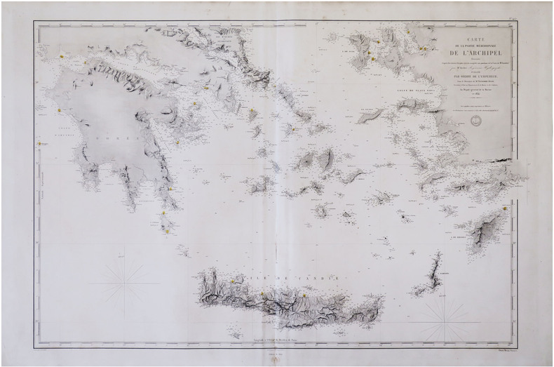
1854LBW-8307[Paris], Dépôt-Général de la Marine, 1854-1864. 591 x 880 mm.
1686LBW-7597Paris, chez l'autheur, 1686. 373 x 539 mm.
Very Good Turkish, Ottoman (1500-1928) Original b/w map on cloth. Very good. Folded. Oblong atlas folio. (54 x 71 cm). In Ottoman script. Scale: 1/2.000.000. [MILITARY MAP of OTTOMAN CAUCASUS] Kafkasya Darü'l-Harekâti. (Fasil: 3 - Numero: 3). Tiflis ve civari, Bahr-i Siyah, Don Kazaklari, Kalmuk, Kirgiz, Bahr-i Hazer-i Kuzgun Denizi (Derya-i Hazar), Kuban Kazaklari, Çerkezistan, Nogay, Termerek Kazalari etc. Military map of Ottoman Caucasus. Shows Tbilisi and around, Khazar Sea, Kuban Cosacks, Don Cosacks, Kalmuks, Kyrgyzstan, Circassia, Nogai, Termerek Cosacks, Maveraünnehir, etc.
Very Good Turkish, Ottoman (1500-1928) Original wrappers. Foolscap 8vo. (18 x 12 cm). In Ottoman script (Old Turkish with Arabic letters). 142, [4] p. Some pages are untrimmed and unopened. Foxing on extremities. Overall a good copy. First and only edition of this uncommon first-hand account in verse of the Siege of Scutari, also referred to as the Siege of Shkodër (Shkodra), took place from 28 October 1912 to 23 April 1913 when the army of the Kingdom of Montenegro defeated the forces of the Ottoman Empire and invaded Shkodër, written by Mehmed Fahri Pasha, who served in Serbia as the chief physician of Shkodra by participating in the Balkan Wars (1912-1913). On 8 October 1912, Turkish General Hasan Riza Pasha announced that Montenegro had declared war on the Ottoman Empire in order to erase 600 years of oppression by the "Turkish foot", as the enemy claimed, and that its troops were crossing the border between Montenegro and Albania. Two hours after the news, the Montenegrin troops, as expected, approached Scutari. As much as 70% of the Turkish army in the interior of the Balkans was composed of Muslim Albanians conscripted during the freedom struggle from the Ottoman Empire. Özege 12224.
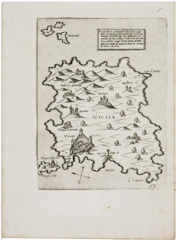
1572LBW-1388[Venise, 1572]. 201 x 150 mm.
VOLUME ONE ONLY. IN GREEK, with running titles in Latin. 13.5x9.5cm. 311 pages. Gilt hardcover. Cover slightly age stained. Spine yellowing. Cover corners and spine edges worn. Pages yellowing and age-stained. Else in good condition.
Very Good Turkish, Ottoman (1500-1928) Original color map on cloth. Oblong atlas folio. (44 x 58 cm). Scale: 1/200.000. Toponyms in Ottoman script /Turkish with Arabic letters). Shows southwest of the Gallipoli Peninsula [and the Hellespont], Edremid Gulf, Tenedos, and North Aegean shores of Anatolia]. Folded. This is one of the series of the Bonn projection maps which are the first map series in modern techniques in Turkey and the Ottoman Empire. In order to produce these maps covering Turkish territory, Reconnaissance Branch was incorporated into The Mapping Commission. The maps were produced in the datum based on the latitude and longitude of the Ayasofya Mosque in equal area Bonn Projection. The field works for the 123 sheets covering the country were conducted by 76 staff. The production was completed in 18 years starting from east-west. Fieldworks continued without stopping except in the years 1914 and 1920. This map series called also reconnaissance maps contributed a lot to producing 1:25.000 scale maps. Hegira: 1336 = Gregorian: 1920. Not description on map-maker. Extremely rare.
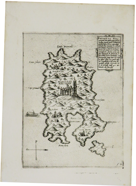
1572LBW-1434[Venise, 1572]. 205 x 156 mm.
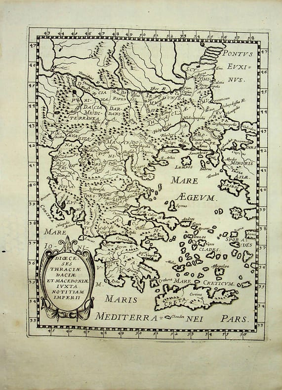
018786[Philippe Briet, Parallela geographiae veteris et novae] Diocèses Thraciae daciae et macedoniae juxta notitiam imperii - Grèce, Macédoine Gravure originale, 1649, environ 240*170mm. Gravure tirée de l'ouvrage du savant jésuite Philippe Briet (1601-1668) publié en 1648-1649. Texte au dos. [436]
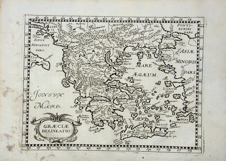
018789[Philippe Briet, Parallela geographiae veteris et novae] Graeciae delineatio - Grèce. Gravure originale, 1649, environ 240*170mm. Gravure tirée de l'ouvrage du savant jésuite Philippe Briet (1601-1668) publié en 1648-1649. Texte au dos. [436]
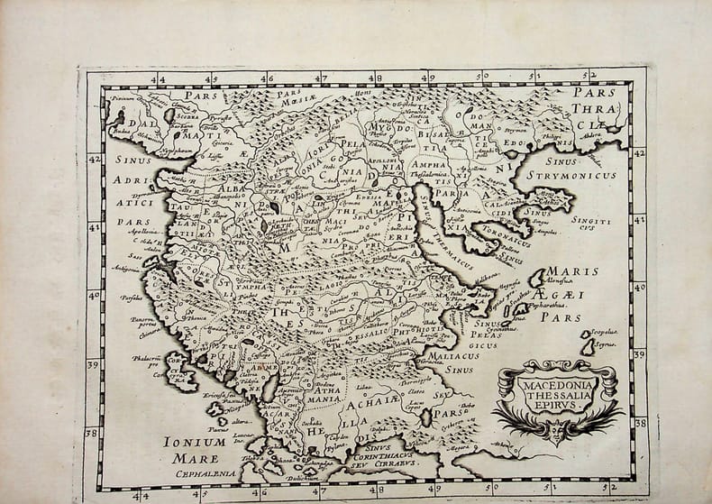
018790[Philippe Briet, Parallela geographiae veteris et novae] Macedonia, Thessalia, Epirus - Macédoine, Thessalie, Epire. Grèce. Gravure originale, 1649, environ 240*170mm. Gravure tirée de l'ouvrage du savant jésuite Philippe Briet (1601-1668) publié en 1648-1649. Texte au dos. [436]
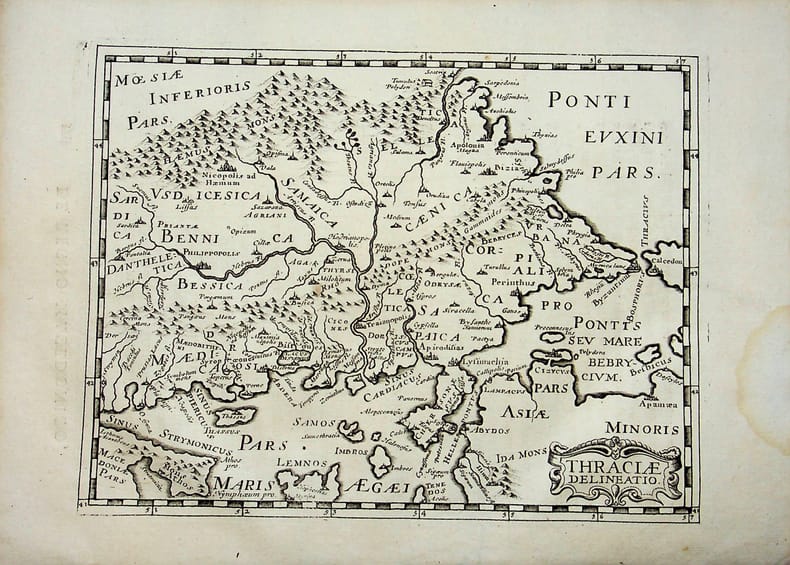
018791[Philippe Briet, Parallela geographiae veteris et novae] Thraciae delineatio - Grèce. Gravure originale, 1649, environ 240*170mm. Gravure tirée de l'ouvrage du savant jésuite Philippe Briet (1601-1668) publié en 1648-1649. Texte au dos. [436]
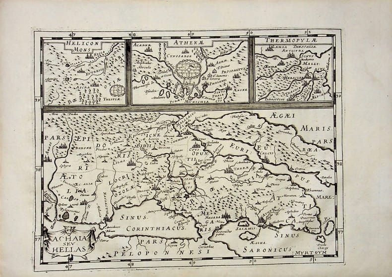
018792[Philippe Briet, Parallela geographiae veteris et novae] Achaia sev Helias - Grèce. Gravure originale, 1649, environ 240*170mm. Gravure tirée de l'ouvrage du savant jésuite Philippe Briet (1601-1668) publié en 1648-1649. Texte au dos. [436]
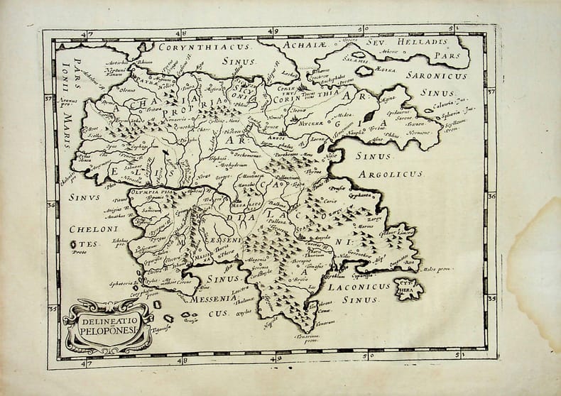
018793[Philippe Briet, Parallela geographiae veteris et novae] Delineatio Peloponesi - Grèce. Gravure originale, 1649, environ 240*170mm. Gravure tirée de l'ouvrage du savant jésuite Philippe Briet (1601-1668) publié en 1648-1649. Texte au dos. [436]
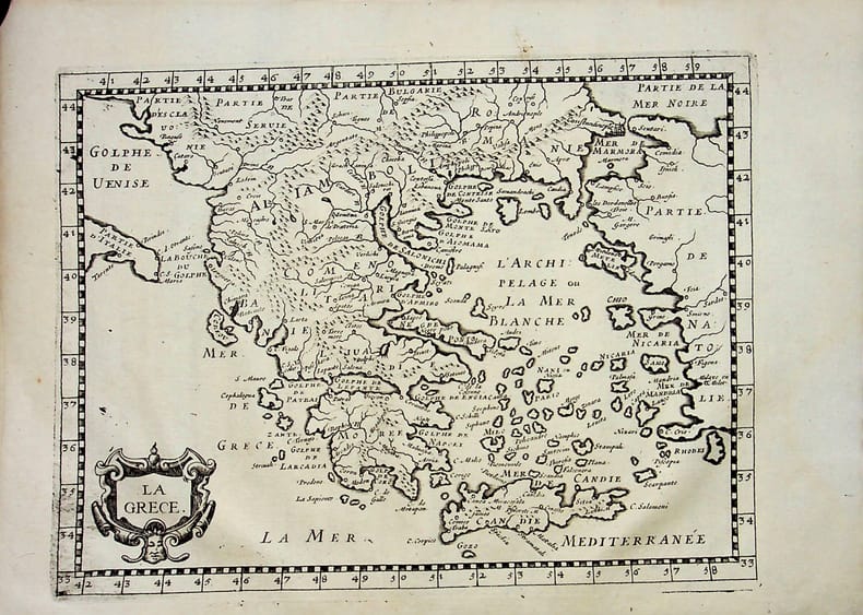
018795[Philippe Briet, Parallela geographiae veteris et novae] La Grèce. Gravure originale, 1649, environ 240*170mm. Gravure tirée de l'ouvrage du savant jésuite Philippe Briet (1601-1668) publié en 1648-1649. Texte au dos. [436]
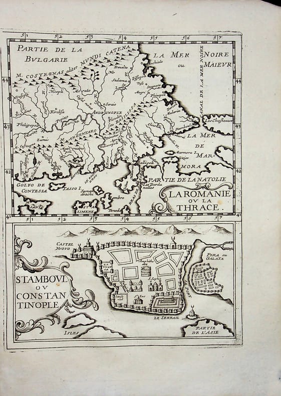
018796[Philippe Briet, Parallela geographiae veteris et novae] La Romanie ou la Thrace - Stamboul ou Constantinople - Grèce et Turquie. Gravure originale, 1649, environ 240*170mm. Gravure tirée de l'ouvrage du savant jésuite Philippe Briet (1601-1668) publié en 1648-1649. Texte au dos. [436]
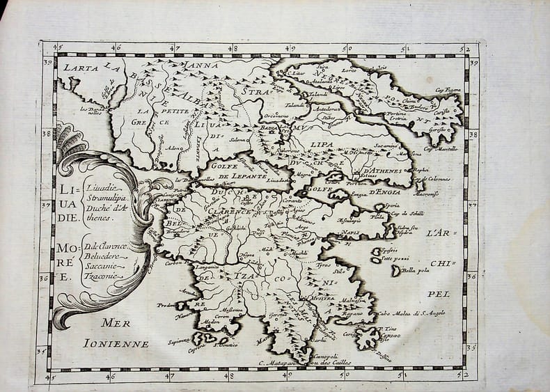
018798[Philippe Briet, Parallela geographiae veteris et novae] Liuadie Morée - Grèce, Golfe de Lépante. Gravure originale, 1649, environ 240*170mm. Gravure tirée de l'ouvrage du savant jésuite Philippe Briet (1601-1668) publié en 1648-1649. Texte au dos. [436]
23.5x12.5 cm. A folding map. Softcover. Pages slightly yellowing. Else in good condition.
Very Good English Original b/w portolan chart. Folded. A little foxing and some pencil markings and notes in Ottoman script in its period. Oblong double elephant folio. (70 x 102 cm). In English. Bosphorus to Kerempeh from the Russian survey of 1834 with additions and corrections by Commander W. J. L. Wharton., R. N. 1872-80. It's written 'London published according to Act of Parliament at the Hydrographic Office of the Admiralty Jare. 16th 1854. Also shows Killa Bay (Shile Bay) from a survey by Lieut. Comm. W. R. Pristen and the midshipmen of H. M. S. Royal Sovereign, 1920. Topography partly from a Turkish map. Up side of map, engraved a view from sea of entrance of the Bosphorus, Rumili (sic. Rumeli) Lighthouse and environment with several hills. And also shows Amastra (Ancient Amastris) from Russian surveys, 1834-41; Kosku Bay from a surbey by Capt. Spratt R. N. 1854; and Sungul Bay (Zonguldak) from the Heraclee Companys plans to 1915. A rare navigation chart.
1572LBW-1452[Venise, 1572]. 157 x 205 mm.