[Roth, Eberhard Rudolph]Antiquariat.de

3 résultats
168463339CBUlm, Verlag Matthäus Wagner, 1684. 12°. 11,5 x 7 cm. 4 Blatt, 408; 84 [recte 48]; 30; 14 Seiten. 10 Faltkarten. Pergamentband der Zeit mit handschriftlichem Rückentitel in Tinte. [6 Warenabbildungen]
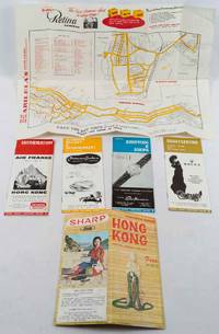
1619220705Hong Kong.: Hong Kong Tourist Association. June 16th1963. Colour folding map and four stapled booklets within original envelope. Map measures 43 x 54.5cm; booklets measure 21.5 x 9.5cm; envelope measures 23 x 10.5cm. Covers of booklets and extremities of envelope somewhat abraded though map in very good condition. A collection of four booklets and a folding map of Kowloon Peninsula and the northern shore of Hong Kong Island prepared for tourists to Hong Kong. The four booklets each focus on general information dining and entertainment sightseeing and shopping. Throughout each booklet particular emphasis is placed on the affordability of travel in Hong Kong and much effort is made to portray the colony as a romantic idyll. . Hong Kong Tourist Association. unknown
165562430CBAmstelodami [Amsterdam], apud Jodocum Jansonium [Johannes Janssonius], 1655. 12°. 14 x 8 cm. 10 Blatt, 340 Seiten, 11 Blatt. 21 (von 22) Karten. Pergamentband der Zeit. [3 Warenabbildungen]