La Perouse; BuffonBiblio.com
162 résultats
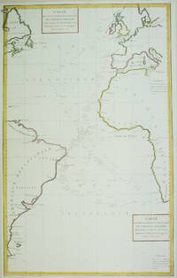
1788M6850Paris 1788. Very Good; laid on acid-free paper for long-term preservation. Notes: This handsome sea chart that indicates magnetic needle readings along various routes through the Atlantic. Size : 850x532 mm 33.46x20.94 Inches Coloring: Hand Colored in Outline Category: Maps Sea Chart; Maps Ocean Atlantic; unknown
17978615<p><strong>Atlas to the first edition of "Voyage de La Perouse"</strong></p><p>Folio. 17 ¼ x 11 ¼ inches.Frontis portrait engraved title page 69 engraved plates. Extra map from English edition.Contemporary binding of leather over marbled boards. Covers very worn front cover completely detached remnants of a hand-written label. Embossed stamp to corner of the title page. A few plates with minor discoloration in the gutter from old tape residue but the plates generally clean some trimmed a bit close. A good copy collated complete and with maps and plates in generally fine condition.</p><p>First edition. Atlas volume only. Bound into this copy is an additional map from the English version of the Atlas; Plate 3 "Chart of the Great Pacific Ocean" as well as a partial piece of the English Plate 4 "Plan of the Bay of Conception in Chili". La Perouse sailed to the Pacific and the west coast of North America to examine regions not explored by Cook; to seek the famous Northwest Passage; to obtain information about the fur trade and the Spanish settlements in California; to make scientific observations; and to promote French enterprise in the region. He made valuable contributions to the history of geographical discovery particularly in regard to the American coast. He sent his dispatches from Kamchatka and Botany Bay. After leaving Botany Bay his expedition disappeared and his ships' wrecks were not discovered for another 39 years on one of the Santa Cruz Islands.</p> [Imprimerie De La Republique] hardcover
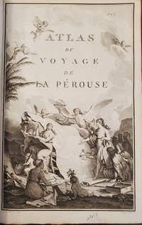
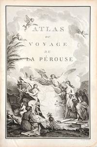
179066877Paris. c.1790. An extremely decorative title page featuring a huge scrolled map assorted angels and winged cherubs together with various seated and standing peoples of the world undoubtedly encountered during the La Perouse voyages. Size: 445 x 295 mm. Copperplate engraving. Good condition. unknown
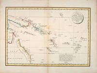
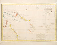
179755868Paris: 1797. Interesting chart of part of the south-western Pacific showing the routes taken by the Spanish explorer Don Francisco Antonio Maurelle in 1781 along the northern coast of New Guinea and across the Pacific to Fiji and Tonga. Maurelle was credited with the discovery of the Hermit Islands on this voyage. The map includes the north-eastern coast of Australia and parts of the coast of New Guinea. The map shows the 1781 route of his ship "The Princesa" through the Bismarck Archipelago north of New Guinea through the Archipel de Salomos i.e. Solomon Islands and then east across the Pacific to the Iles de Amis i.e. the Friendly Islands now Tonga where he discovered I. Vavao i.e. Vava'u with one of the best anchorages in the South Pacific. The map includes the Iles de Navigateurs i.e. Samoa I. Fidji i.e. Fiji Iles de Esprit i.e. Vanuatu or the New Hebrides Isles and Nouvelle Caledonie i.e. New Caledonia. Many small islands are depicted with notes regarding their sightings by Abel Tasman William Bligh and Maurelle. A note on the chart states that the publisher has placed the islands according to the longitude of other navigators rather than on Maurelle's figures which were considered estimates only and also that Maurelles chart was based on a French chart by Jacques Nicolas Bellin published in 1742. The French cartographers at the time did not consider the Spanish charts to be sufficiently accurate so they preferred to make their own corrections. Size: 490 x 340 mm. Copper engraving. Hand coloured. Good condition. Watermark slight browning and an old repair to the central fold. Good margins. unknown
178553439Atlas du Voyage de la Perouse. c.1785. Interesting chart of part of the south-western Pacific showing the routes taken by the Spanish explorer Don Francisco Antonio Maurelle in 1781 along the northern coast of New Guinea and across the Pacific to Fiji and Tonga. Maurelle was credited with the discovery of the Hermit Islands on this voyage. The map includes the north-eastern coast of Australia and parts of the coast of New Guinea. The map shows the 1781 route of his ship "The Princesa" through the Bismarck Archipelago north of New Guinea through the Archipel de Salomos i.e. Solomon Islands and then east across the Pacific to the Iles de Amis i.e. the Friendly Islands now Tonga where he discovered I. Vavao i.e. Vava'u with one of the best anchorages in the South Pacific. The map includes the Iles de Navigateurs i.e. Samoa I. Fidji i.e. Fiji Iles de Esprit i.e. Vanuatu or the New Hebrides Isles and Nouvelle Caledonie i.e. New Caledonia. Many small islands are depicted with notes regarding their sightings by Abel Tasman William Bligh and Maurelle. A note on the chart states that the publisher has placed the islands according to the longitude of other navigators rather than on Maurelle's figures which were considered estimates only and also that Maurelle's chart was based on a French chart by Jacques Nicolas Bellin published in 1742. The French cartographers at the time did not consider the Spanish charts to be sufficiently accurate so they preferred to make their own corrections. Copper engraving. Good condition. One light and one dark spot of foxing to the upper centre. A slight faint watermark. Later colour. Size: 49 x 34 cm. 19½ x 13½ inches unknown
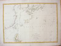
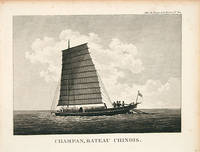
1787M7397Paris c.1787. Very Good;. Size : 495x680 mm 19.49x26.77 Inches Coloring: Hand Colored in Outline Category: Maps Asia Far East China; Maps Asia Far East Japan & Korea; unknown
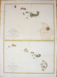
1798M7217Paris 1798. Very Good;small restoration at left margin. Size : 490x678 mm 19.29x26.69 Inches Coloring: Hand Colored Category: Maps United States West Hawaii; unknown
1797016791Paris: La Perouse 1797. Map. Very good condition. Unbound. First Edition. Folio. A large map in black and white. The map is included in the Atlas volume of La Perouse's Voyages. The west coast of North America is shown as south as Baja California and north to above 70 degrees latitude. Shows part of China and all of Japan and Kamtschatka and an attractive depiction of the Behring Straits and the Alaskan Archipelago. There are about a dozen small dark spots and dozens of others that are tiny but the map remains quite clean retaining large margins. La Perouse Paperback
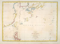
179755879Paris:. 1797. From the Voyages of La Pérouse who set sail from France in 1785 to continue the discoveries of Captain Cook. He was shipwrecked in 1788 but his narrative maps and views survived and were published in 1797. Fine large chart shows the southern coast of China Japan Korea Formosa & the Philippines and the Marianas as well as many small islands in the region. Locates the tracks of the Boussoles the Astrolabe the ships of La Perouse on his voyage from Manila to Kamtschatka. Chart shows very detailed soundings and all known harbours straits and island chains. Engraved by BOUCLET. Atlas Du Voyage De La Pérouse Size: 675 x 490 mm. Copper engraving. Hand coloured. Fine condition. Slight browning to the lower margin. Good margins. unknown
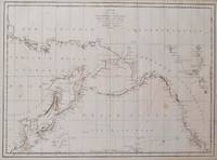
179755870Paris: 1797. A large and imposing sea chart of the North Pacific ocean. From the Voyages of La Pérouse who set sail from France in 1785 to continue the discoveries of Captain Cook. He was shipwrecked in 1788 but his narrative maps and views survived and were published in 1797. Copper engraving. Very good condition. Watermarks. Good margins. Hand coloured. Size: 68.5 x 49.5 cm. unknown
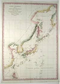
179755878Paris: 1797. From the Voyages of La Pérouse who set sail from France in 1785 to continue the discoveries of Captain Cook. He was shipwrecked in 1788 but his narrative maps and views survived and were published in 1797. An attractive map of the regions North of Japan withs two inset maps: Extrait de la carte publiee par Scheuchzer -- Extrait de la carte de l'Histoire du Japon de Kampfer. Relief shown pictorially; depths by soundings. Oriented with north toward right. Atlas Du Voyage De La Pérouse. Size: 675 x 490 mm. Copper engraving. Hand coloured. Very good condition. A faint vertical waterstain. Good margins. unknown
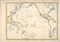
179755869Paris: 1797. A splendid large chart of the Pacific Ocean and of those countries that border it. Only coastal information is given. From the Voyages of La Pérouse who set sail from France in 1785 to continue the discoveries of Captain Cook. He was shipwrecked in 1788 but his narrative maps and views survived and were published in 1797. Copper engraving. Very good condition. Faint waterstain along the left vertical fold. Very slight foxing not affectong the image. Hand coloured. Size: 68.5 x 49.5 cm. unknown
1797M753Paris 1797. Excellent. Size : 685x495 mm 27x19.5 Inches Coloring: Hand Colored Category: Maps Asia Far East China; Maps Asia Far East Japan & Korea; unknown
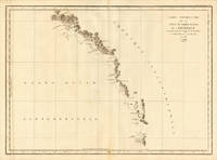
179724538Paris 1797. Other. In excellent condition. 690 by 490mm 27 by 19 inches. 690 by 490mm 27 by 19 inches. Copper Engraving uncolored by La Perouse Jean-Francois de Galup published 1797 by Paris. Image size: 690 by 490mm 27 by 19 inches. By Lapérouse — among the rarest and most historically important charts of the Northwest Coast ever produced. Jean-François de Galaup Comte de Lapérouse 1741–1788 was the foremost French navigator and explorer of the late 18th century. Commissioned by Louis XVI to lead a major scientific and commercial expedition to the Pacific he departed Brest in 1785 with two frigates — the Boussole and the Astrolabe — and spent three years charting the Pacific and North American coasts with extraordinary precision. His charts of the Northwest Coast of North America 1786 were the first scientific surveys of many sections of that coastline and were published posthumously in the celebrated four-volume Voyage de Lapérouse autour du monde 1797. The expedition disappeared without trace near Vanikoro in 1788. Lapérouse's charts are among the most historically important and rarest maps of the Pacific and Northwest Coast ever produced.This antique map of Carte Générale D `une Partie de la Cote du Nord-Quest. De L´ was published in 1797 by Paris 690 by 490mm 27 by 19 inches. It is printed as a copper engraving uncolored. The map documents the region with careful attention to rivers settlements roads and political boundaries reflecting the geographical knowledge available at the time of publication and offering an invaluable primary source for historians and collectors of North American antique cartography. In excellent condition. unknown
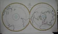
1788M5521Paris 1788. Very Good folding map flattened and folds reinforced laid on acid free canvas for long term preservation. Notes: "Double hemispherical world map with each hemisphere shown on polar projection. Plate probably accompanied: Histoire naturelle generale et particulare / George Louis Leclerc Buffon. Paris 1749-1804. Plate "No. 8" of an 8 sheet map which was probably compiled from the reports of La Perouse’s last voyage in the Pacific and is by Jean-Charles Borda." National Library of Australia Digital Collection map-rm3253 Size : 480x940 mm 18.875x37 Inches Coloring: Hand Colored in Outline Category: ; Maps Polar Antarctic Regions; Maps Polar Arctic Regions unknown
178624580Paris 1786. Other. In excellent condition. 490 by 860mm 19¼ by 33¾ inches. Copper engraving uncolored as published. unknown
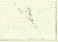
178624536Paris 1786. Other. In excellent condition. 495 by 685mm 19 by 27 inches. 495 by 685mm 19 by 27 inches. Copper Engraving uncolored by La Perouse Jean-Francois de Galup published 1786 by Paris. Image size: 495 by 685mm 19 by 27 inches. By Lapérouse among the rarest and most historically important charts of the Northwest Coast ever produced. Jean-François de Galaup Comte de Lapérouse 17411788 was the foremost French navigator and explorer of the late 18th century. Commissioned by Louis XVI to lead a major scientific and commercial expedition to the Pacific he departed Brest in 1785 with two frigates the Boussole and the Astrolabe and spent three years charting the Pacific and North American coasts with extraordinary precision. His charts of the Northwest Coast of North America 1786 were the first scientific surveys of many sections of that coastline and were published posthumously in the celebrated four-volume Voyage de Lapérouse autour du monde 1797. The expedition disappeared without trace near Vanikoro in 1788. Lapérouse's charts are among the most historically important and rarest maps of the Pacific and Northwest Coast ever produced.This antique map of Carte Particuliere de la Còte du Nord-Quest de L Amerique r was published in 1786 by Paris 495 by 685mm 19 by 27 inches. It is printed as a copper engraving uncolored. The map documents the region with careful attention to rivers settlements roads and political boundaries reflecting the geographical knowledge available at the time of publication and offering an invaluable primary source for historians and collectors of North American antique cartography. In excellent condition. 495 by 685mm 19 by 27 inches. unknown
1797M2909Paris 1797. Very Good; light dampstain on lower margin. Size : 494x677 mm 19.375x26.625 Inches Coloring: Black & White Category: Maps Polar Arctic Regions Alaska Greenland Iceland; unknown
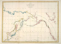
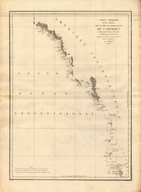
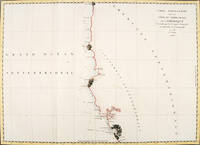
elala4671Paris: 1797. This map shows La PÈrouseís 1786 northwest coast exploration route from Mount St. Elias on the Alaska-Canada border to ëBaie de Clonardí a cove on the west side of Graham Island. La PÈrouse was appointed to lead a French expedition which would further the scientific and geographical exploration of the northwest. He was also charged with continuing the search for the North-West passage from the Pacific side. Wagner Cartography Of The Northwest Coast Of America 841. Phillips Atlases 688. Falk Alaskan Maps 1797-9. 19 ºî x 26 æî. engraving paper flaws below upper border & lower margin [Paris: 1797] unknown
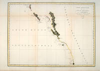
179756360Paris. 1797. From the Voyages of La Pérouse who set sail from France in 1785 to continue the discoveries of Captain Cook. He was shipwrecked in 1788 but his narrative maps and views survived and were published in 1797. Thirty-eight years later the scattered remains of La Boussole and L'Astrolabe was discovered wrecked on a vicious reef on an atoll in the New Hebrides. Attractive sea chart covering coast from Mt. St. Elias to Monterey Bay. Relief shown by hachures. Shows route of La Perouse. Published in 'Atlas Du Voyage De La Pérouse'. Size: 575 x 845 mm. Copper engraving. Hand coloured. Very good condition; some light stains along the lower horizontal fold; a tear and some foxing to the upper margin; wide margins. unknown
179755871Paris: 1797. From the Voyages of La Pérouse who set sail from France in 1785 to continue the discoveries of Captain Cook. He was shipwrecked in 1788 but his narrative maps and views survived and were published in 1797. Two watermarks one on each side of the islands. Engraved by Bouclet. Atlas Du Voyage De La Pérouse. Size: 680 x 495 mm. Copper engraving. Hand coloured. Very good condition. Faint waterstain on the left vertical fold and slight foxing to the upper horizontal fold not affecting the image. Good margins. unknown
1797151Paris: Imprimerie de la République 1797. First Edition. Folio Leaf. Very Good. Hérault / Bouclet. Elephant Folio. Leaf measures 33.25" x 23.25" while the printed chart is 26.5" x 19.5". Fold at center as issued. Condition is Very Good with very light foxing within the plate and slightly darker foxing in the top right margin. A dampstain the size of a fifty-cent piece at the lower right corner outside the border rule and not affecting print impression. La Pérouse was France's answer to Captain James Cook. Directed by King Louis XVI to explore and chart the Pacific in 1785 La Pérouse set sail from France with the frigates Boussole and Astrolabe . and never returned. After years of speculation and expeditions sent in search of the ships their 1788 shipwrecked-fate in the South Seas was finally ascertained. Prior to disappearing La Pérouse dispatched a courier homeward overland via Russia with his narrative charts and artist-depictions to-date. His achievements were published in 1797 including this chart.<p>This chart covering the coastline from Cape Rond Tillamook Head northward to the Baie de Clonard present-day Queen Charlotte Islands or Haida Gwaii was the only chart of the region other than works by or based on Cook's efforts. Three Spanish voyages and Cook's third voyage had visited the west coast of now-known Vancouver Island before La Pérouse. As depicted in this chart the land mass is not yet known by the place-name "Vancouver" nor is it recognized as an island. LADA-MOCARSKI 52 claims the best charting by La Pérouse is on the Asian side of the Pacific. Indeed it must be noted that La Pérouse like Cook missed both the Columbia River and the Strait of Juan de Fuca. See WAGNER Cartography of the Northwest Coast of America 840. Imprimerie de la République unknown
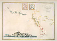
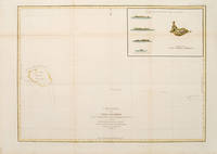
179755873Paris: 1797. From the Voyages of La Pérouse who set sail from France in 1785 to continue the discoveries of Captain Cook. He was shipwrecked in 1788 but his narrative maps and views survived and were published in 1797. Sea chart showing Necker Island a small island in the Pacific Ocean part of the Nortwestern Hawaiian Islands. La Perouse was the first European to visit the island in 1786. Map inset in the right top corner showing profiles of the island from different angles. Atlas Du Voyage De La Pérouse. Size: 680 x 485 mm. Copper engraving. Hand coloured. Very good condition. Faint waterstain to the left vertical fold. Good margins. Watermarks. Folds as issued. unknown
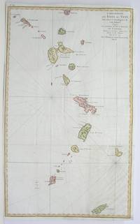
1796M3355Paris 1796. Very Good; lower margin extended. Size : 606x362 mm 23.875x14.25 Inches Coloring: Hand Colored Category: ; Maps West Indies Whole unknown
1797558961797. From the Voyages of La Pérouse who set sail from France in 1785 to continue the discoveries of Captain Cook. He was shipwrecked in 1788 but his narrative maps and views survived and were published in 1797. Thirty-eight years later the scattered remains of La Boussole and L'Astrolabe was discovered wrecked on a vicious reef on an atoll in the New Hebrides. Engraved by Le Pagelet. Size: 250 x 180 mm. Fine condition. Some foxing to the lower margin not affecting the image. unknown