[La Perouse]Biblio.com

162 résultats
180021185London 1800. Very good overall. Copper engraving of two Tlingit women of the Pacific Northwest. Port des Francais is now known as Lituya Bay in southeast Alaska. The engraving depicts the women at the sea coast seated under trees wearing fur cloaks one viewed in profile each with lip plates or labrets. Engraved by Deeves after a drawing by Prior. From Voyage de La Perouse Autour du Monde. 4to 8x 10" paper; 6 1/4 x 8 1/2" image. unknown
196855058Amsterdam And NY: N. Israel and Da Capo Press. Near Fine. 1968. Hardcover. Two volume set; lacks atlas volume. Faux vellum gilt. Facsimile edition. Corners lightly bumped. Contents fine. The clear plastic DJs have some chips/tears. ; quarto . N. Israel and Da Capo Press hardcover
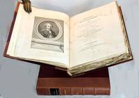
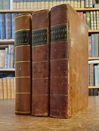
1799101564London: A. Hamilton for G. G. and J. Robinson J. Edwards and T. Payne. 1799. First thus two text volumes quarto later half-leather binding with gilt title labels and raised bands spines cloth sides Vol. I: pp. x lvi 539; Vol. II: pp. viii 531 plus index and errata page pp xiii. Engraved frontis portrait plate of La Perouse by Heath in first volume light water stain to upper plate and title page all edges untrimmed some unopened at top edge very light scattered foxing mostly to title pages minor scuffs to leather spine. The two text volumes without the Atlas volume complete and unabridged. Very good condition. The first quarto unabridged and "best edition" in English. A translation of La Perouse's scientific voyage around the world which departed France in 1785 and visited Chile and Hawaii Alaska California Japan Russia the South Pacific and Australia visiting Botany Bay in 1788 before sailing on and eventually discovered to have been wrecked in the Solomon Islands. A landmark work of exploration. 1st thus. Half leather. A. Hamilton for G. G. and J. Robinson, J. Edwards and T. Payne, hardcover
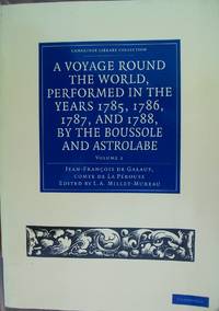
2011H048095--ParCambridge University Press. FREE U.K. Shipping. FAMILY Business. FIRST Class Service. Full refund if not totally satisfied. 2011 Paperback edition. excellent condition. Volume 2. Book is heavy and will incur a postal surcharge outside of the U.K. . Very Good. Soft cover. 1st Edition. 2011. Cambridge University Press paperback
1968208132Amsterdam. Nico Israel. 1968. 4to. 539547pp. Publisher's mylar djs on text volumes. Sl.discolouration to the spine of the atlas volume. Scarce. Bibliotheca Australiana nos. 27 28 & 29 Facsimile re-issue of the London edition of 1799. An interesting French perspective on the arrival of the First Fleet in 1788. Amsterdam. Nico Israel. unknown
17988611<p><strong>First visit of a foreigner to missionary establishments in Upper California</strong></p><p>3 volumes. Octavo 8½x5 inches. Pp. x 2 532 x 498 viii 466 1-60 Tables. 42 copper-engraved maps views charts and specimens mostly folding. Full brown calf gilt & blind rules on spines black leather spine labels. Volume I rebacked to match with original spine label and new endpapers. Bookplates on inner covers of volumes II and III. Early inked signature on each title page crossed out ink on verso of titles. Front hinges of volumes II and III broken but attached rear hinges starting. General wear to edges and corners. Most maps and plates foxed or toned small closed tear to p.477-78 of Volume II with remnants of old repair folding frontis plate in volume III with early paper reinforcement on the verso of one fold. Overall a very good set. Collated complete.</p><p>First English edition. "There are three separate translations into English from the original French of which two this one published by Johnson and another one published by Stockdale appeared in the same year 1798. Johnson's was issued slightly earlier. Both of these 1798 editions are abridged. In both first English printings the number of maps were reduced "Stockdale's edition reproduced only fifty-one of the original plates and Johnson's edition only forty-two" Hill. La Perouse sailed to the Pacific and the west coast of North America to examine regions not explored by Cook; to seek the famous Northwest Passage; to obtain information about the fur trade and the Spanish settlements in California; to make scientific observations; and to promote French enterprise in the region. He made valuable contributions to the history of geographical discovery particularly in regard to the American coast. He sent his dispatches from Kamchatka and Botany Bay. After leaving Botany Bay his expedition disappeared and his ships' wrecks were not discovered for another 39 years on one of the Santa Cruz Islands. Hill <em>Collection of Pacific Voyages</em>: p. 974.</p> Printed for J. Johnson, St. Paul’s Church Yard hardcover
138579917X.Ghardcover. Good. Access codes and supplements are not guaranteed with used items. May be an ex-library book. hardcover
196850398Amsterdam and New York: N. Israel and Da Capo Press 1968. Later printing. Hardcover. Very good condition. Quarto. 25391; 253117pp. Index. Plus facsimiles of the original 1799 title pages and 56 facsimile pages of the original prefaces and introductions. Publisher's mylar dust jackets. Faux vellum boards with gilt lettered blue labels on front covers and spines.<br /> <br /> "Bibliotheca Australiana #27 and #28."<br /> <br /> The text is complete in two volumes but this set lacks the atlas volume and is priced accordingly. Mylar with wear small chips and tears some tears larger. N. Israel and Da Capo Press hardcover
117147234X.Gpaperback. Good. Access codes and supplements are not guaranteed with used items. May be an ex-library book. paperback
1385794992.Ghardcover. Good. Access codes and supplements are not guaranteed with used items. May be an ex-library book. hardcover
1385831642.Ghardcover. Good. Access codes and supplements are not guaranteed with used items. May be an ex-library book. hardcover
1171460058.Gpaperback. Good. Access codes and supplements are not guaranteed with used items. May be an ex-library book. paperback
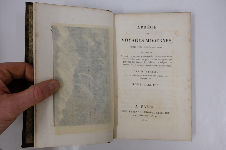
VOY918M1822-1824, Étienne Ledoux, Paris. Complet. 14 volumes in-8, demi-basane havane de l' époque, dos lisse orné, titre et tomaison dorés. Fronttispices illustrés. [2]-XII-469-[2], [6]-473-[2], [6]-498-[2], [6]-445-[2], [6]-474-[2], [6]-496-[2], [6]-478-[2], [6]-473-[2], [6]-489-[2], [6]-475-[2], [6]-479-[2], [6]-481-[2], [6]-474-[2], [6]-426-[2]. Volumes non coupés. Frottements diffus des dos, coins et coiffes. Pièces de titre et tomais parfois effacées. Intérieur globalement agréable. Usure normale du papier. Ensemble satisfaisant
180051892London 1800 2 volumes in-8 et un atlas in-4, demi-basane blonde, dos lisse orné de roulettes et fers dorés rel. post., LXII- 464- VII- 423- 43 pp. & 6 pp. - 44 planches gravées dont une grande carte dépliante. Quelques brunissures marginales, hum. angulaire sans gravité sur près de 50 pp. au second volume de texte et 12 planches légère et sans atteinte aux gravures. Bon exemplaire.
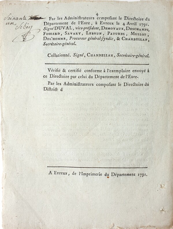
17914212Evreux, Imprimerie du département, 1791. 1791 2 ff. in-folio (244 x 196 mm.) de 4 pp. Imprimées. Bandeau gravé en entéte, note signée à lencre noire en marge de la p. 4. (traces de plis et de trous en marges). Non relié, conservé tel que paru dans une chemise de papier d'époque.
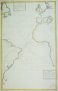
1788M6850Paris 1788. Very Good; laid on acid-free paper for long-term preservation. Notes: This handsome sea chart that indicates magnetic needle readings along various routes through the Atlantic. Size : 850x532 mm 33.46x20.94 Inches Coloring: Hand Colored in Outline Category: Maps Sea Chart; Maps Ocean Atlantic; unknown
17978615<p><strong>Atlas to the first edition of "Voyage de La Perouse"</strong></p><p>Folio. 17 ¼ x 11 ¼ inches.Frontis portrait engraved title page 69 engraved plates. Extra map from English edition.Contemporary binding of leather over marbled boards. Covers very worn front cover completely detached remnants of a hand-written label. Embossed stamp to corner of the title page. A few plates with minor discoloration in the gutter from old tape residue but the plates generally clean some trimmed a bit close. A good copy collated complete and with maps and plates in generally fine condition.</p><p>First edition. Atlas volume only. Bound into this copy is an additional map from the English version of the Atlas; Plate 3 "Chart of the Great Pacific Ocean" as well as a partial piece of the English Plate 4 "Plan of the Bay of Conception in Chili". La Perouse sailed to the Pacific and the west coast of North America to examine regions not explored by Cook; to seek the famous Northwest Passage; to obtain information about the fur trade and the Spanish settlements in California; to make scientific observations; and to promote French enterprise in the region. He made valuable contributions to the history of geographical discovery particularly in regard to the American coast. He sent his dispatches from Kamchatka and Botany Bay. After leaving Botany Bay his expedition disappeared and his ships' wrecks were not discovered for another 39 years on one of the Santa Cruz Islands.</p> [Imprimerie De La Republique] hardcover
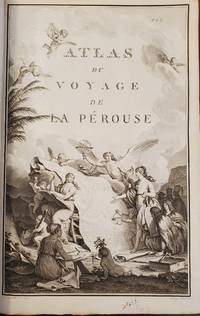
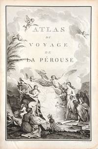
179066877Paris. c.1790. An extremely decorative title page featuring a huge scrolled map assorted angels and winged cherubs together with various seated and standing peoples of the world undoubtedly encountered during the La Perouse voyages. Size: 445 x 295 mm. Copperplate engraving. Good condition. unknown
Les Isambres, chez l'auteur, 1955. In-8 broché de 116 pages. Illustrations. Bel exemplaire
18474061Paris, Belin-Leprieur et Morizot, (1847). 22 gravures sur bois, 23 planches, dont quelques unes en couleurs / 22 Holzschnitte, 23, teils farbige Tafeln, 474 S., 1 Bl., goldgeprägter, illustrierter Original-Leinenband mit Goldschnitt. Zustand 2, Namenseintrag in Tinte auf Spiegel.
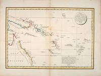
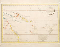
179755868Paris: 1797. Interesting chart of part of the south-western Pacific showing the routes taken by the Spanish explorer Don Francisco Antonio Maurelle in 1781 along the northern coast of New Guinea and across the Pacific to Fiji and Tonga. Maurelle was credited with the discovery of the Hermit Islands on this voyage. The map includes the north-eastern coast of Australia and parts of the coast of New Guinea. The map shows the 1781 route of his ship "The Princesa" through the Bismarck Archipelago north of New Guinea through the Archipel de Salomos i.e. Solomon Islands and then east across the Pacific to the Iles de Amis i.e. the Friendly Islands now Tonga where he discovered I. Vavao i.e. Vava'u with one of the best anchorages in the South Pacific. The map includes the Iles de Navigateurs i.e. Samoa I. Fidji i.e. Fiji Iles de Esprit i.e. Vanuatu or the New Hebrides Isles and Nouvelle Caledonie i.e. New Caledonia. Many small islands are depicted with notes regarding their sightings by Abel Tasman William Bligh and Maurelle. A note on the chart states that the publisher has placed the islands according to the longitude of other navigators rather than on Maurelle's figures which were considered estimates only and also that Maurelles chart was based on a French chart by Jacques Nicolas Bellin published in 1742. The French cartographers at the time did not consider the Spanish charts to be sufficiently accurate so they preferred to make their own corrections. Size: 490 x 340 mm. Copper engraving. Hand coloured. Good condition. Watermark slight browning and an old repair to the central fold. Good margins. unknown
178553439Atlas du Voyage de la Perouse. c.1785. Interesting chart of part of the south-western Pacific showing the routes taken by the Spanish explorer Don Francisco Antonio Maurelle in 1781 along the northern coast of New Guinea and across the Pacific to Fiji and Tonga. Maurelle was credited with the discovery of the Hermit Islands on this voyage. The map includes the north-eastern coast of Australia and parts of the coast of New Guinea. The map shows the 1781 route of his ship "The Princesa" through the Bismarck Archipelago north of New Guinea through the Archipel de Salomos i.e. Solomon Islands and then east across the Pacific to the Iles de Amis i.e. the Friendly Islands now Tonga where he discovered I. Vavao i.e. Vava'u with one of the best anchorages in the South Pacific. The map includes the Iles de Navigateurs i.e. Samoa I. Fidji i.e. Fiji Iles de Esprit i.e. Vanuatu or the New Hebrides Isles and Nouvelle Caledonie i.e. New Caledonia. Many small islands are depicted with notes regarding their sightings by Abel Tasman William Bligh and Maurelle. A note on the chart states that the publisher has placed the islands according to the longitude of other navigators rather than on Maurelle's figures which were considered estimates only and also that Maurelle's chart was based on a French chart by Jacques Nicolas Bellin published in 1742. The French cartographers at the time did not consider the Spanish charts to be sufficiently accurate so they preferred to make their own corrections. Copper engraving. Good condition. One light and one dark spot of foxing to the upper centre. A slight faint watermark. Later colour. Size: 49 x 34 cm. 19½ x 13½ inches unknown
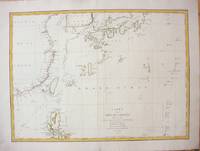
1787M7397Paris c.1787. Very Good;. Size : 495x680 mm 19.49x26.77 Inches Coloring: Hand Colored in Outline Category: Maps Asia Far East China; Maps Asia Far East Japan & Korea; unknown
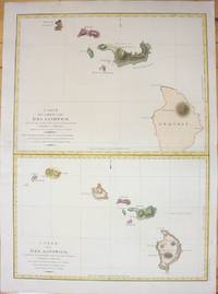
1798M7217Paris 1798. Very Good;small restoration at left margin. Size : 490x678 mm 19.29x26.69 Inches Coloring: Hand Colored Category: Maps United States West Hawaii; unknown
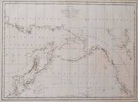
1797016791Paris: La Perouse 1797. Map. Very good condition. Unbound. First Edition. Folio. A large map in black and white. The map is included in the Atlas volume of La Perouse's Voyages. The west coast of North America is shown as south as Baja California and north to above 70 degrees latitude. Shows part of China and all of Japan and Kamtschatka and an attractive depiction of the Behring Straits and the Alaskan Archipelago. There are about a dozen small dark spots and dozens of others that are tiny but the map remains quite clean retaining large margins. La Perouse Paperback