LA PEROUSE, Jean Francois de GalaupBiblio.com
104 résultats
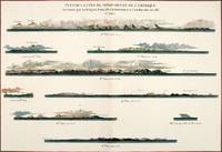
179756368Paris: 1797. Nine profiles showing Mt. Beautems Mt. Crillon Mt.St. Hyacinthe Port Guibert Iles des Espagnols Iles Necker Necker Islands Ile Sn. Carlos Pointe des Brisants present Estevan Point and Baie Clonard Beresford Bay. The map is from the Voyages of La Pérouse who set sail from France in 1785 to continue the discoveries of Captain Cook. He was shipwrecked in 1788 but his narrative maps and views survived and were published in 1797. Thirty-eight years later the scattered remains of La Boussole and L'Astrolabe was discovered wrecked on a vicious reef on an atoll in the New Hebrides. Atlas Du Voyage De La Pérouse. Paris: Copper engraving. Very good condition; slight browning along the centrefold and foxing to wide margins a tear to the bottom margin along the centrefold not affecting the image. Hand coloured. Size: 58.5 x 43 cm. unknown
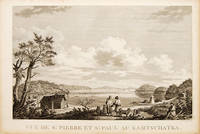
179755670Atlas Du Voyage De La Pérouse. 1797. View of St Pierre and St Paul in Kamtschatka. From the Voyages of La Pérouse who set sail from France in 1785 to continue the discoveries of Captain Cook. He was shipwrecked in 1788 but his narrative maps and views survived and were published in 1797. Size: 400 x 255 mm. Copper engraving. Uncoloured. Very good condition. slight browing around edges but not effecting image. unknown
1987BN257250Stuttgart ; Wien : Ed. Erdmann 1987. 1987. Zu den Klippen von Vanikoro : Weltreise im Auftr. Ludwigs XVI. 1785 - 1788. Jean-François de Lapérouse. Nach Lapérouses Tagebüchern aufgezeichn. von M. L.-A. Milet-Mureau. Übers. bearb. u. hrsg. von Klaus Fischer / Alte abenteuerliche Reiseberichte <br/><br/>Zu den Klippen von Vanikoro : Weltreise im Auftr. Ludwigs XVI. 1785 - 1788. Jean-François de Lapérouse. Nach Lapérouses Tagebüchern aufgezeichn. von M. L.-A. Milet-Mureau. Übers. bearb. u. hrsg. von Klaus Fischer / Alte abenteuerliche Reiseberichte La Pérouse Jean-François de Galaup und Klaus Fischer Stuttgart ; Wien : Ed. Erdmann unknown
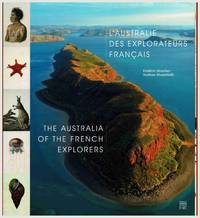
2014106444n.p.: Somogy Editions d'Art. 2014. 1st ed. square quarto text in French and English pp.192 profusely illus with colour and b&w plates maps photographs original boards in dust-jacket. Near fine condition. Explorations to the Australian coast of French explorers during the 18th and 19th centuries documented here through contemporary photographs expedition drawings and historical commentary. Explorers include Saint-Alouarn La Perouse Bruny d'Entrecasteaux Labillardiere Baudin Henri Freycinet Louis Freycinet Rose Freycinet Hamelin Peron and others. Includes artworks by artists Lesueur and Petit. 1st edition. Boards in d.j. Somogy Editions d'Art hardcover