La Perouse, Jean-Francois de GalaupBiblio.com

162 résultats
2012632408.Gpaperback. Good. Access codes and supplements are not guaranteed with used items. May be an ex-library book. paperback
2019162040.Gpaperback. Good. Access codes and supplements are not guaranteed with used items. May be an ex-library book. paperback
179853622Paris Plassin 1798. 8vo. and folio 44 x 30 cm. Textvolumes bound in 4 contemporary half calf. Gilt spines with gilt lettering. Tome-label on volume one eroded. Stamp on title-pages. 4LXVIII368;4414;316120 = Tables;4328 pp. A few scattered brownspots. Atlasvolume bound in matching hcalf. Spine gilt and rubbed. Lower compartment of spine with wear and tear. Engraved portrai of Pérouse as frontispiece. Engraved pictorial titlepage with cupids and naviogational instruments dessinée par Moreau le Jeune and 69 engraved maps plans and plates of which 32 are large folded engraved maps. Mild foxing to some parts of some maps occasionally mild dampstains to some plates marginal browning and some spotting. One map with a repair to folding. <br/><br/><em>Second edition of the textvolumes the first appeared the year before 1797 and first edition of plates. 69 plates to the first 70 to the second."In 1785 Jean-Francois de Galaup Comte de la Perouse began preparations for an extensive sea voyage. His aim was to explore the Pacific regions of North and South America Asia and Australasia. The sponsor of the expedition was the French king Louis XVI who was inspired by Captain James Cook's Pacific voyages. Louis ordered the French expedition to show the world that France could also dominate in ocean exploration. The expedition consisted of two ships - La Boussole and L'Astrolabe. They carried a total of 225 crew officers and scientists. The ships left France in August 1785 and sailed south around Cape Horn. The voyage was expected to last four years. During the voyage La Perouse sent back regular reports to France. The expedition mapped coastlines and explored uncharted areas of ocean. The expedition's scientists also spent time onshore at various ports observing the habits and customs of local people and collecting natural history specimens. The expedition's progess until September 1787 was published by the French government as Voyage de La Perouse autour du monde La Perouse's voyage around the world. It was reprinted many times and translated into several languages. In 1791 when La Perouse had not returned to France or made any contact by dispatch the French government sent out a search party. It was commanded by Rear Admiral Joseph Antoine Bruni d'Entrecasteaux and consisted of two ships Recherche and Esperance. The complete disappearance of La Perouse caught the imagination of the European public. Songs stories and plays were written about the possible fate of the expedition including a popular play called Perouse or The desolate island. It was not until 1964 that the wreck of La Boussole was finally discovered on Vanikoro's reefs. At last the fate of La Perouse and his crew was known. The expedition is commemorated in the name of a Sydney suburb on the shores of Botany Bay - La Perouse." State Library of New South Wales Website.Sabin 38960. </em> unknown
A Paris, de l'Imprimerie Impériale, 1808. Tome I seul, Un volume très fort In-folio, relié cartonnage d'attente de l'époque, LVI + 704 pages et 32 planches dépliantes. Le corps de l'ouvrage est en très bon état, les pages, à grandes marges ne sont ni tachées ni affectéees de rousseurs, imprimées sur beau papier. Les planches dépliantes sont également en bon état, présentant juste quelques petites pointes de rousseurs dans les marges sans gravité. La reliure (cartonnage d'attente) est en mauvais état. Rappelons que d'Entrecateaux avait été envoyé, en 1781) par Louis XVI à la recherche de La Pérouse
1801843601801. LA PEROUSE Jean Francois. A Voyage Round the World. Performed in the Years 1785 1786 1787 1788.TO which are added A Voyage from Manilla to California by Don Antonio Maurelle: and an Abstract of the Voyage and Discoveries of the Late Capt. G. Vancouver. Boston: Joseph Bumstead 1801 333pp. Contemporary full leather morocco spine label skillfully rebacked. Some toning throughout else very good. Hill 976. Sabin 38966. Howes L-93. Forbes 331. Shaw & Shoemaker 789. Ferguson 333. Reese Best of the West 20. Kroepelien 1331.The rare first American edition of one of the most important Pacific voyages. The La Perouse account was first published in Paris in French in 1797 and in English in 1798. This is one of the earliest Pacific voyages to appear in an American edition and published much less modestly than the French and British editions would have been the way the average American would have learned about La Perouse's important surveys of the Pacific coast and his descriptions of native Americans there. This is also the first American version although only a precis of Vancouver's voyage first published in London in 1798. The 1781 voyage of Spanish naval officer Francisco Antonio Mourelle incorrectly spelled in this edition's title went from the Philippines to the South Pacific where he explored in the vicinity of New Guinea and the Tonga Islands before sailing to Mexico. Howes is inaccurate in his pagination of this edition and the Hill copy contains a map that was added later. unknown
179755666Paris. 1797. Scene showing inhabitants of Lituya Bay Alaska in fishing season. From the Voyages of La Perouse who set sail from France in 1785 to continue the discoveries of Captain Cook. He was shipwrecked in 1788 but his narrative maps and views survived and were published in 1797. Atlas Du Voyage De La Pérouse. Size: 400 x 255 mm. Copper engraving. Uncoloured. Very good condition. slight browing around edges but not effecting image. unknown
179755645Paris. 1797. This dramatic and attractive print is from the Voyages of La Perouse who set sail from France in 1785 to continue the discoveries of Captain Cook. He was shipwrecked in 1788 but his narrative maps and views survived and were published in 1797. Atlas du Voyage de la Perouse Copper engraving. Good margins crisp clear impression very good condition. slight browing around edges but not effecting image Uncoloured. Size: 40 x 25.5 cm. unknown
179755649Paris. 1797. View of Brazil from the Voyages of La Perouse who set sail from France in 1785 to continue the discoveries of Captain Cook. He was shipwrecked in 1788 but his narrative maps and views survived and were published in 1797. Atlas Du Voyage De La Pérouse. Copper engraving. Very good condition. slight browing around edges but not effecting image. Uncoloured. Size: 40 x 25.5 cm. unknown
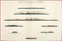
179756369Paris: 1797. Eight profiles showing Mt. la Touche Baie de la Touche present Englefield Bay C. Hector present Cape St. James I. Kerouard Iles Sartine Scott Islands and Cap Blanc. The map is from the Voyages of La Pérouse who set sail from France in 1785 to continue the discoveries of Captain Cook. He was shipwrecked in 1788 but his narrative maps and views survived and were published in 1797. Thirty-eight years later the scattered remains of La Boussole and L'Astrolabe was discovered wrecked on a vicious reef on an atoll in the New Hebrides. Atlas Du Voyage De La Pérouse. Paris: Copper engraving. Very good condition; slight browning along the centrefold and foxing to wide margins a tear to the bottom margin along the centrefold not affecting the image. Hand coloured. Size: 58.5 x 43 cm. unknown
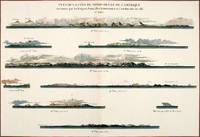
179756368Paris: 1797. Nine profiles showing Mt. Beautems Mt. Crillon Mt.St. Hyacinthe Port Guibert Iles des Espagnols Iles Necker Necker Islands Ile Sn. Carlos Pointe des Brisants present Estevan Point and Baie Clonard Beresford Bay. The map is from the Voyages of La Pérouse who set sail from France in 1785 to continue the discoveries of Captain Cook. He was shipwrecked in 1788 but his narrative maps and views survived and were published in 1797. Thirty-eight years later the scattered remains of La Boussole and L'Astrolabe was discovered wrecked on a vicious reef on an atoll in the New Hebrides. Atlas Du Voyage De La Pérouse. Paris: Copper engraving. Very good condition; slight browning along the centrefold and foxing to wide margins a tear to the bottom margin along the centrefold not affecting the image. Hand coloured. Size: 58.5 x 43 cm. unknown
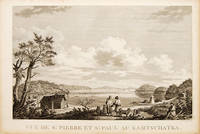
179755670Atlas Du Voyage De La Pérouse. 1797. View of St Pierre and St Paul in Kamtschatka. From the Voyages of La Pérouse who set sail from France in 1785 to continue the discoveries of Captain Cook. He was shipwrecked in 1788 but his narrative maps and views survived and were published in 1797. Size: 400 x 255 mm. Copper engraving. Uncoloured. Very good condition. slight browing around edges but not effecting image. unknown
1987BN257250Stuttgart ; Wien : Ed. Erdmann 1987. 1987. Zu den Klippen von Vanikoro : Weltreise im Auftr. Ludwigs XVI. 1785 - 1788. Jean-François de Lapérouse. Nach Lapérouses Tagebüchern aufgezeichn. von M. L.-A. Milet-Mureau. Übers. bearb. u. hrsg. von Klaus Fischer / Alte abenteuerliche Reiseberichte <br/><br/>Zu den Klippen von Vanikoro : Weltreise im Auftr. Ludwigs XVI. 1785 - 1788. Jean-François de Lapérouse. Nach Lapérouses Tagebüchern aufgezeichn. von M. L.-A. Milet-Mureau. Übers. bearb. u. hrsg. von Klaus Fischer / Alte abenteuerliche Reiseberichte La Pérouse Jean-François de Galaup und Klaus Fischer Stuttgart ; Wien : Ed. Erdmann unknown