60 résultats
1769MAP1016London: Russell and Price 1769. Original Map . No Binding. Fine. 4to. Single page map of the County of NOTTINGHAM SHIRE John Roque. Published in ENGLAND DISLAYED Being a New Complete and Accurate Survey and Description of the Kingdom of England and Principality of Wales. Plate 16 x20cm sheet 160 x 243mm. Fine original map printed on laid paper. Uncoloured. 2ND EDITION pub. 1769. OTHER COUNTIES ARE AVAILABLE FROM THIS ISSUE. <br/> <br/> Russell and Price unknown
1769Map1005London: Russell and Price 1769. Original Map . No Binding. Fine. 4to. Single page map of the County of ISLE OF WIGHT John Roque.Published in ENGLAND DISLAYED Being a New Complete and Accurate Survey and Description of the Kingdom of England and Principality of Wales. Plate 16 x20cm sheet 160 x 243mm. Fine original map printed on laid paper. Uncoloured. 2ND EDITION pub. 1769. OTHER COUNTIES ARE AVAILABLE FROM THIS ISSUE <br/> <br/> Russell and Price unknown
1758T370Dublin: John Exshaw Dame Street 1758. No Binding. Fine. 8vo. 427-480pp. A disbound copy of the Dublin version of the Gentleman's Magazine for the month of August 1758. Fine fresh paper with no foxing wear or marks. The title-page lists 24 articles on the title-page and includes a fine copy of the rare 'A PLAN of the Harbour and TOWN of LOUISBOURG in the Island of CAPE BRETON Drawn on the Spot. Folding page 28 x 20 cms with a plate impression 24 x 18 cms.4 page description of the plan and town. Other articles include an estimate of the Naval Debt; Part of the trial of William Barnard; Journal of the Seige of Louisbourg; General Abercromby's Account of the Exped. to Crown Point. Single page map of 'The Country between CROWN POINT and ALBANY being the Great Pass from the English to the French Settlements in North America'.11.5 x 19.1 cms. Please email for photos. <br/> <br/> John Exshaw, Dame Street unknown
1758T372Dublin: John Exshaw Dame Street 1758. 1st Edition . No Binding. Fine. 8vo. 313-368pp. A disbound copy of the Dublin version of the Gentleman's Magazine for the month of June 1758. Fine fresh paper with no foxing wear or marks. The title-page lists 24 articles on the title-page and includes a fine copy of the rare folding map 'A NEW MAP OF THE ENGLISH CHANNEL' engraved by Ridge 25 x 17 cms. Map engraved by Ridge. Title contents calls for a Sheet map of Germany and not the English Channel. Please email for photos. <br/> <br/> John Exshaw, Dame Street unknown
1758T373Dublin: John Exshaw Dame Street 1758. 1st Edition . No Binding. Fine. 8vo. 3-64pp. A disbound copy of the Dublin version of the Gentleman's Magazine for the month of January 1758. Fine fresh paper with no foxing wear or marks. The title-page lists 21 articles on the title-page and includes a fine copy of the rare folding map 'Island Rathlin showing the Ballycastle Colleries 21x18 cms. Also A PLAN OF THE CITY OF BRESLAU Capital of Silesia 18x12 CMS.Please email for photos. <br/> <br/> John Exshaw, Dame Street unknown
1758T374Dublin: John Exshaw Dame Street 1758. 1st Edition . No Binding. Fine. 8vo. 369-425pp. A disbound copy of the Dublin version of the Gentleman's Magazine for the month of July 1758. Fine fresh paper with no foxing wear or marks. The title-page lists 19 articles on the title-page and includes a fine copy of the rare folding sheet map 'A New and Accurate Map of Germany Drawn from the latest surveys Discribing the Port Roads & Distances from Town to Town according to the original Map of the Prussion Routs Published at berlin By Richd Bennet Engineer'. Engraved by S. Wheatley.33x26 cms. Trifle margin crop lower corner. Title-page call for a map of the Channel Islands but Germany map present. Please email for photos. <br/> <br/> John Exshaw, Dame Street unknown
1758T371Dublin: John Exshaw Dame Street 1758. 1st Edition . No Binding. Fine. 8vo. 481-536pp. A disbound copy of the Dublin version of the Gentleman's Magazine for the month of Sept 1758. Fine fresh paper with no foxing wear or marks. The title-page lists 25 articles on the title-page and includes a fine copy of the rare 'Plan of the Country from the LANDING PLACE with the Encampments and Marches of the Troops under Major General ABERCROMBIE to the Attack of TICONDEROGA . 19 x11 cms. Together with an account from the action. Also a fine plan of St Malo with map of part of French Coast inset 19 x 11cms together with an account of shipping lost in recent action. Also a PLAN of Cherburg with Channel map inset 19 x 11cms with an account. All 3 plans engraved by Ridge. Please email for photos. <br/> <br/> John Exshaw, Dame Street unknown
1758W196Dublin: John Exshaw Dame Street 1758. 1st Edition . Audio Book DVD. Fine. 8vo. 595-648pp. A disbound copy of the Dublin version of the Gentleman's Magazine for the month of November 1758. Fine fresh paper with no foxing wear or marks. The title-page lists 25 articles on the title-page and includes a fine copy of the rare map 'A Plan of Milford Haven' by Ridge; 19 x 12 cms. Articles include the capture of Fort Frontemac. Major Grant debacle at Fort Quesne. Please email for photos. <br/> <br/> John Exshaw, Dame Street unknown
1758W204Dublin: John Exshaw Dame Street 1758. 1st Edition . No Binding. Fine. 8vo. 131-192pp. A disbound copy of the Dublin version of the Gentleman's Magazine for the month of April 1758. Fine fresh paper with no foxing wear or marks. The title-page lists 24 articles on the title-page. Articles include History of the last campaign in North America 214-221; The Idler A New Paper; Account of the pilgrimages to Mecca; Temoray foot bridge over the Thames is consumed by fire; etc Please email for photos. <br/> <br/> John Exshaw, Dame Street unknown
1758W201Dublin: John Exshaw Dame Street 1758. 1st Edition . No Binding. Fine. 8vo. 259-312pp. A disbound copy of the Dublin version of the Gentleman's Magazine for the month of May 1758. Fine fresh paper with no foxing wear or marks. The title-page lists 22 articles on the title-page. Articles include The Effects of Camphire on a 'lunatic'.; York rioters ordered for execution; Shipping lists; The conduct of Admiral Knowles. Please email for photos. <br/> <br/> John Exshaw, Dame Street unknown
1704TH254London: printed for John Nicholson and Samuel Ballard 1704. The Seventh Edition . Hardback. Fine. 12mo. Being a geographical index. Of all the considerable cities patriachships. in Europe. The seventh edition corrected and very much enlarged with the addition of a table of births marriages &c. of.Unpaginated.256pp. Both parts present. The second part being The Births marriages etc of all the Kings Princes and Potentates of Europe. Original full calf binding with panelled polished calf boards and attractive decoration to the corners of the outer panel. Robbed to the extremities but a nice copy. PLEASE EMAIL FOR PHOTOS. <br/> <br/> printed for John Nicholson, and Samuel Ballard hardcover
1716Pa888London: John Nicholson and Samuel Ballad 1716. eleventh edition . Hardback. Vg. 12mo. ii pubs. ad. including maps and atlases by Herman Moll. i pp ad Preface incl. The Clavis i pp vi Gazetteer a5-Ll5; iii pub. book lists.; bound with the Second Part THE GAZETTEER'S OR NEWMAN'S INTERPRETER Being a Geographical Index .in Asia Africa and America pub. by George Sawbridgeand Maurice Atkins London the third edition Corrected and Enlarged 1710 Preface iv Or Divers Measures iii The Clavis i pp The Gazeteer A6- M5 pub. ads iii pp. Original full calf with raised bands. Single gilt ruled borders to the boards. <br/> <br/> John Nicholson and Samuel Ballad hardcover
1740TH228London: Printed for Thomas Wright Mathematical Instrument-Maker. And E. Cushee Globe-Make 1740. fifth Edition . Hardback. Vg. 8vo. THE DESCRIPTION AND USE OF THE GLOBES AND THE ORRERY To which is prefixed by way of introduction a brief Account of the Solar System.viii 190pp. 6 folding plates. Pub. advert to the reverse of the title-page. Index of the astronomical terms. Original full calf polished calf binding with gilt dbl. ruled border to the boards. Five raised band and neat owners to the top edge of the title-page. A tight clean and fresh copy with a plain but period binding Near fine Nicholson Calvert 1816 an English Whig politicain who fought at the Battle of Waterloo. <br/> <br/> Printed for Thomas Wright, Mathematical Instrument-Maker. And E. Cushee, Globe-Make hardcover
1745TH352London: Printed for Thomas Wright Mathematical Instrument-Maker. And E. Cushee Globe-Make 1745. sixth edition . Hardback. Vg. 8vo. To which is prefixed by way of introduction a brief Account of the Solar System.viii 190pp. 6 folding plates. Pub. advert to the reverse of the title-page. Index of the astronomical terms. Original full calf calf binding. Five raised bands. A tight clean and fresh copy with a plain but period bindng/ Original binding intact but worn to the extremities and joints cracked but the boards attached. A tight and clean text with beautiful crisp plates. <br/> <br/> Printed for Thomas Wright, Mathematical Instrument-Maker. And E. Cushee, Globe-Make hardcover
1769Map1007London: Russell and Price 1769. Original Map . No Binding. Fine. 4to. Single page map of the County of SUSSEX John Roque. Published in ENGLAND DISLAYED Being a New Complete and Accurate Survey and Description of the Kingdom of England and Principality of Wales. Plate 16 x20cm sheet 160 x 243mm. Fine original map printed on laid paper. Uncoloured. 2ND EDITION pub. 1769. OTHER COUNTIES ARE AVAILABLE FROM THIS ISSUE. <br/> <br/> Russell and Price unknown
1769MAP1010London: Russell and Price 1769. Original Map . No Binding. Fine. 4to. Single page map of the County of SURREY John Roque. Published in ENGLAND DISLAYED Being a New Complete and Accurate Survey and Description of the Kingdom of England and Principality of Wales. Plate 16 x20cm sheet 160 x 243mm. Fine original map printed on laid paper. Uncoloured. 2ND EDITION pub. 1769. OTHER COUNTIES ARE AVAILABLE FROM THIS ISSUE. <br/> <br/> Russell and Price unknown
1769MAP1024London: Russell and Price 1769. Original Map . No Binding. Fine. 4to. Single page map of the County of STAFFORD SHIRE John Roque. Published in ENGLAND DISLAYED Being a New Complete and Accurate Survey and Description of the Kingdom of England and Principality of Wales. Plate 16 x20cm sheet 160 x 243mm. Fine original map printed on laid paper. Uncoloured. 2ND EDITION pub. 1769. OTHER COUNTIES ARE AVAILABLE FROM THIS ISSUE. <br/> <br/> Russell and Price unknown
1769MAP1018London: Russell and Price 1769. Original Map . No Binding. Fine. 4to. Single page map of the County of SHROP SHIRE John Roque. Published in ENGLAND DISLAYED Being a New Complete and Accurate Survey and Description of the Kingdom of England and Principality of Wales. Plate 16 x20cm sheet 160 x 243mm. Fine original map printed on laid paper. Uncoloured. 2ND EDITION pub. 1769. OTHER COUNTIES ARE AVAILABLE FROM THIS ISSUE. <br/> <br/> Russell and Price unknown
1769MAP1017London: Russell and Price 1769. Original Map . No Binding. Fine. 4to. Single page map of the County of RUTLAND SHIRE John Roque. Published in ENGLAND DISLAYED Being a New Complete and Accurate Survey and Description of the Kingdom of England and Principality of Wales. Plate 16 x20cm sheet 160 x 243mm. Fine original map printed on laid paper. Uncoloured. 2ND EDITION pub. 1769. OTHER COUNTIES ARE AVAILABLE FROM THIS ISSUE. <br/> <br/> Russell and Price unknown
1760Map1001London: T. Bowen 1760. Original First Edition . No Binding. Fine. c1760 A fine example of Bowens map of Portugall. Title within an oval frame. An uncoloured example and printed of thick paper. 2 vertical folds to the page but nice clean margins and a dark impression. Some minor foxing reflecting its age but a nice example. 'Prepared for Barlow's General History of Europe'. Blank reverse. 33x34cms Barlows volume is often very damp stained and foxed. This map is however a fine example. Thomas Bowen 1714-1767 <br/> <br/> T. Bowen unknown
1773Map922London: H. Turpin 1773. 3rd Edition . No Binding. Fine. Single map of Lincolnshire. A fine uncoloured copy of the last issue of Robert Moderns playing card maps. Approx 55x90mms. Title to the head wth Roman numeral VIII and the uncoloured map to the main section enclosed with double ruled lines above and below with county dimensions and distances at the foot. Harry Turpin published a 52 sheet set of these maps between 1764 and 1787 but no exact date is known for publication. RARE. Please email for photos. <br/> <br/> H. Turpin unknown
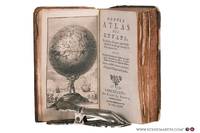
178078258Bruxelles: Benoît Le Francq 1780. Full leather hardcover. xx240 pp. illustrated with a black-and-white frontispiece showing Atlas as a child holding up the celestial sphere and 24 old hand-colored folding maps/plates after G. Dellisle. Rare Brussels pocket atlas based on the 5th Amsterdam edition published by B. Vlam in the same year 1780. Includes B. Vlam's bookseller's list at the end. One map has a repaired taped tear and some maps have frayed edges. Bound in a leather cover with various damages. The book is complete and the maps remain visually attractive. Text in French / Français. See pictures. Benoît Le Francq hardcover
1769MAP1015London: Russell and Price 1769. Original Map . No Binding. Fine. 4to. Single page map of the County of NOTTINGHAM SHIRE John Roque. Published in ENGLAND DISLAYED Being a New Complete and Accurate Survey and Description of the Kingdom of England and Principality of Wales. Plate 16 x20cm sheet 160 x 243mm. Fine original map printed on laid paper. Uncoloured. 2ND EDITION pub. 1769. OTHER COUNTIES ARE AVAILABLE FROM THIS ISSUE. <br/> <br/> Russell and Price unknown
1769MAP1025London: Russell and Price 1769. Original Map . No Binding. Fine. 4to. Single page map of the County of CUMBERLAND John Roque. Published in ENGLAND DISLAYED Being a New Complete and Accurate Survey and Description of the Kingdom of England and Principality of Wales. Plate 16 x20cm sheet 160 x 243mm. Fine original map printed on laid paper. Uncoloured. 2ND EDITION pub. 1769. OTHER COUNTIES ARE AVAILABLE FROM THIS ISSUE. <br/> <br/> Russell and Price unknown
1769MAP1013London: Russell and Price 1769. Original Map . No Binding. Fine. 4to. Single page map of the County of NORTHAMPTON SHIRE John Roque. Published in ENGLAND DISLAYED Being a New Complete and Accurate Survey and Description of the Kingdom of England and Principality of Wales. Plate 16 x20cm sheet 160 x 243mm. Fine original map printed on laid paper. Uncoloured. 2ND EDITION pub. 1769. OTHER COUNTIES ARE AVAILABLE FROM THIS ISSUE. <br/> <br/> Russell and Price unknown