333 résultats
1840GT692London: Longman Rees Orme. 1840. 1st issue . Cloth. Vg. Folding map. WALKERS COUNTY MAP SERIES. nd C1840. Origina green boards with the original label with an attractive border. Folding map of Wiltshire laid on linen and folded into 15 sections. Out-line hand-colour coloured woods and railway lines. An attractive travellers map in a v.g. condition. 41 x 34cms.Parliamentary divisions updated in 1830. Please email for photos. <br/> <br/> Longman Rees Orme. hardcover
1823Map926London: Robt. Wilkinson 1823. 1st Edition . Hardback. Vg. Folio. 52 coloured plates - 45 maps 7 chrono-geological charts 7 maps double-page. Orignal boards and spine. Fine contents with hand-coloured maps thoughout. Rubbed and worn boards but a sound binding needing new paper covering pasted to the boards.The fine map plates are dated between 1800 and 1823 <br/> <br/> Robt. Wilkinson hardcover
1804Map934Paternoster Row London: Longman Hurst Rees & Orme 1804. 1st Edition 1st Printing. No Binding. Fine. Original early 19th century map CHART OF THE PACIFIC WEST INDIES BY AARON ARROWSMITH. A FINE CLEAN AND DARK IMPRESSION. Original folding plate including Honduras Watermarked paper 1804. A scarce example and in fine un-coloured original condition.41x27cms. Double-page. <br/> <br/> Longman, Hurst, Rees & Orme unknown
1991022980Chapel Hill: University of North Carolina Press 1991. BRAND NEW in a BRAND NEW dust jacket. Perfect condition. Still sealed in the publisher's clear plastic shrink wrap. NO chips. NO tears. NO creases. NO rubbing. NO fading. Sharp corners. Bright and shiny. Fresh crisp clean and unmarked. 1991. First Printing of the First Edition with complete number row 54321 on the copyright page. Illustrated with more than 100 maps bird's-eye views engravings etchings collotypes aquatints mezzotints steel engravings wood engravings and lithographs. Most are in full color. Includes notes on the artists printers publishers and history of the city. Views are accompanied by 97 excerpts from contemporary published works of visitors and residents e. g. Charles Dickens Frederick Marryat Harriet Martineau Benjamin Perley Poore Anthony Trollope Francis Trollope Mark Twain Walt Whitman. Bound in the original light gray cloth stamped in bright gold over a black panel on the spine. Complete with pristine dust jacket. Oversize Hardcover. Oblong. 15" wide by 11.5" tall. This VERY large VERY heavy book will require SUBSTANTIAL extra postage for Priority and International shipments but only the standard charge for media mail. . First Printing of the First Edition. Oversize Hardcover. New/New in publisher's shrinkwrap. xiv 297pp. Great Packaging Fast Shipping. University of North Carolina Press Hardcover
1769MAP1016London: Russell and Price 1769. Original Map . No Binding. Fine. 4to. Single page map of the County of NOTTINGHAM SHIRE John Roque. Published in ENGLAND DISLAYED Being a New Complete and Accurate Survey and Description of the Kingdom of England and Principality of Wales. Plate 16 x20cm sheet 160 x 243mm. Fine original map printed on laid paper. Uncoloured. 2ND EDITION pub. 1769. OTHER COUNTIES ARE AVAILABLE FROM THIS ISSUE. <br/> <br/> Russell and Price unknown
1816Map685Edinburgh: John Thomson 1816. 1st Edition . No Binding. Fine. Original hand-colour fine scarce unfolded copy minor damp stain 510 X 610 From John Thomsons New General Atlas 1817 beautifully hand-coloured on thick paper <br/> <br/> John Thomson unknown
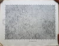
19693792<p>A very uncommon map of the Sea of Tranquility area that would be the site of the first moon landing in 1969. According to a description of a related larger-scale map in a 2020 Bonham's auction "NASA mission planners created this internal Manned Spacecraft Center chart a few months before the flight in 1969."</p><p>The map encompasses the area from 14 degrees South to 14 degrees North Latitude and from 0 degrees to 42 degrees East Longitude. The coordinates of the Eagle's landing site were 0.675 degrees Latitude North and 23.47 degrees Longitude East – very near the center of the mapped area.</p><p>The map is numbered "MSC – 6238 – 69" in the lower right margin. As it was meant for internal use only the map appears to be significantly less common than the LAC Lunar Chart series and the USGS geologic chart series. We were unable to locate an online reference to the map on the Lunar and Planetary Institute website.</p><p><strong>Condition: </strong>Rolled never folded. Some crinkling in the lower margin. Tear at extreme lower right corner with map number has been closed with archival tape on the reverse. Good.</p><p>ICN 7706.1.</p> NASA Manned Spacecraft Center
193560001New York: John Day Reynal & Hitchcock 1935. 4to. xiv 351 1 pp. With 56 maps most full-page numerous text illustrations. Blue publisher’s cloth silver lettering front cover & spine minor shelfwear light rubbing at head & foot of spine corners w/ d.j. striking Art Deco cover art of ships voyaging minor creasing edgewear couple closed tears on back cover wear to corners still NF/VG- copy inscribed by author on half-title. First edition inscribed of this unashamedly Eurocentric voyages and exploration history detailing “all the great adventurers by land and sea from Hannu 2750 B.C. to Piccard 1935.†The specially prepared maps specifically show the ground and oceans covered by each explorer with the contemporary “Known World†starkly defined. The maps and histories sequentially “unroll†from the very small area around the Mediterranean to the World. Outhwaite 1892-1979 was an anthropologist who worked on American race relations at the Laura Spelman Rockefeller Memorial from 1923-1028 worked for the Rockefeller Foundation through the 1930’s and organized “Outhwaite Exhibits†for museums World’s Fairs and window displays. He also was an adventurer who sailed 14000 miles on the Atlantic Ocean from 1929-1930 onboard the yacht “Kinkajou†visiting Mt. Pelee Martinique. John Day, Reynal & Hitchcock, hardcover
1805Map935Paternoster Row London: Longman Hurst Rees & Orme 1805. 1st Edition 1st Printing. No Binding. Fine. Original early 19th century map MAP OF THE EASTERN COAST AND LANDS OF THE UNITED STATES BY AARON ARROWSMITH. A FINE CLEAN AND DARK IMPRESSION. Original folding plate covering North Florida to Lower Canada Watermarked heavy paper 1804. A scarce example and in fine un-coloured original condition.41x27cms. Double-page. <br/> <br/> Longman, Hurst, Rees & Orme unknown
1997017766Mansfield Centre Connecticut: Martino Fine Books 1997. Brand New in perfect condition. 2 vols in 1. STILL SEALED in the publisher's clear plastic SHRINKWRAP. NO rubbing. NO fading. Bright clean square and tight. Sharp corners. NO owner's name or bookplate. NOT a remainder. Fresh and crisp -- obviously never read. n. d. but 1997. HARDCOVER reprint limited to 150 copies of the 1950 and 1953 Library of Congress originals. 2 volumes bound as 1 with a total of 767 pages. Because this edition is bound in sturdy cloth it is much better suited to heavy use than the paper bindings of the original editions. A welcome reprint of an important and scarce reference. Described here are 6696 atlases. Entries are first arranged geographically and by subject national; state; and within the various states by county/parish city and region; special subject atlases include agriculture aviation canals climate coal geology history languages railroads etc. Then the atlases are re-listed by author/publisher in the index. A typical entry includes the atlas title; cartographer; publisher; city and date of first publication; dimensions in centimeters; number of pages plates and maps; the number that are colored etc. Occasional notes on contents. In the second part copies of the atlases held by some 180 libraries are located. Hodgkiss/Tatham KEYGUIDE TO INFORMATION SOURCES IN CARTOGRAPHY: "An indispensable reference for students of American history or of the development of American cartography." Bound in the original gilt-stamped blue cloth. Besterman 6267. Sheehy CL288. KEYGUIDE 94. 1997 reprint of 1950/53 originals. Hardcover. New/in publisher's shrinkwrap. 2 vols in 1: viii445pp. xiii301pp. 767 total. Great Packaging Fast Shipping. Martino Fine Books Hardcover
1953003010New York: American Society of Civil Engineers 1953. Fine condition. Bright clean square and tight. Sharp corners. Gilt on cover is still bright and shiny. No owner's name or bookplate. Pages are fresh and crisp. No underlining. No highlighting. No margin notes. Illustrations throughout. Author Index. Subject Index. Includes: A HUNDRED YEARS OF AMERICAN CIVIL ENGINEERING 1852-1952 by J. K. Finch pp. 28-96; AN ENGINEERING CENTURY IN CALIFORNIA by Walter L. Huber pp. 97-111; SURVEYING AND MAPPING IN CANADA 1852-1952 by F. H. Peters pp. 857- 871; WATERWAY GROWTH IN THE UNITED STATES by William L. Hartley pp. 976-1041; HISTORY AND FUTURE OF FLOOD CONTROL by George R. Schneider pp. 1042- 1099; etc. There are also papers on Civil Engineering - History and Practice; Engineering Education; City Planning; Construction; Irrigation; Power Sanitary Engineering; Soil Mechanics; Structural; Surveying; Transportation; Waterways; Allied Interests Metals in the Economy; Synergism between Engineering and Petroleum; Iron and Steel Production 1851-1951. Bound in the original black cloth. . First Edition. Hardcover. Fine condition/No dust jacket. 8vo. xii 1330pp. American Society of Civil Engineers Hardcover
1964P266Amsterdam: Meridian Publishing Company 1964. facimile reprint . Hardback. Fine/V G Chipped. small folio. 192pp including 19 double page maps in black and white and an introduction by R.A. Skelton. A facsimile edition of the first atlas entirely devoted separately to the Americas. Originally published in 1597. A series of atlases in Facsimile. First series volume V. Original d.j. now proected by a clear mylar wrapper <br/> <br/> Meridian Publishing Company hardcover
195282192Minneapolis:: Printed for the Author by the Voyageur Press 1952. First edition; one of Sixty Copies Printed. Two looseleaf albums . Generally fine. 8vo. A comprehensive album for collecting postage stamps featuring maps from around the world with spaces to affix specimens and information about each stamp. In this example there are approximately 150 affixed stamps and 133 blank spaces for stamps. Printed for the Author by the Voyageur Press, unknown
1842Map 806Edinburgh: A&C Black 1842. No Binding. Fine/uncoloured. World map with Australia at the middle 140 degrees. Beautiful steel engraving from Encyclopaedia Britanica Seventh edition dated 1842. Plate CCLXIII. Fine example with no wear. Australia is named 'Australia and New Holland'. 410x260mm. Relief is shown by hachures. Engraved by S. Hall Bury Strt. Bloomsbury. Published by A. & C. Black. Engd. by G. Aikman Edinr. <br/> <br/> A&C Black unknown
1807Map942Paternoster Row London: Longman Hurst Rees & Orme 1807. 1st Edition 1st Printing. No Binding. Fine. Original early 19th century MAP OF THE WORLD On MERCATORS PROJECTION BY AARON ARROWSMITH. A FINE CLEAN AND DARK IMPRESSION. Original folding plate covering THE WHOLE WORLD printed on heavy paper dated 1807. A scarce example and in fine un-coloured original condition. 41x27cms. Double-page folding map.Engraved by Lodge.A LOVELY COPY <br/> <br/> Longman, Hurst, Rees & Orme unknown
1885MH045London: Blackie & Son 1885. 1st Edition . Hardcover. Fine. small 4to. Volume One only of two. cxiv 468pp. Original half calf with raised bands and dec. compartments. Green morocco label with titles in gilt. Original pub. half calf binding bound by Blackie of an interesting and well illustrated view of the world in the late Victorian period. 9 maps 16 plates <br/> <br/> Blackie & Son hardcover
1842Map 805Edinburgh: A&C Black 1842. No Binding. Fine/uncoloured. Folding plate of the two hemispheres. Beautiful steel engraving from Encyclopaedia Britanica Seventh edition dated 1842. Plate CCLXII. Fine example with no wear. Couple of small fox marks. Engraved by S. Hall Bury Str. Bloomsbury. Australia is named 'Australia and New Holland'. 400x280mm. <br/> <br/> A&C Black unknown
1806Map943Paternoster Row London: Longman Hurst Rees & Orme 1806. 1st Edition 1st Printing. No Binding. Fine. Original early 19th century MAP OF THE WORLD On MERCATORS PROJECTION BY AARON ARROWSMITH. A FINE CLEAN AND DARK IMPRESSION. Original folding plate covering THE WORLD printed on heavy paper dated 1807. A scarce example and in fine un-coloured original condition. 41x27cms. Double-page folding map.A NICE COPY <br/> <br/> Longman, Hurst, Rees & Orme unknown
1959031767New York: Frederick A. Praeger 1959. Two volumes complete with original slipcase published in 1959 at $47.50. Both volumes are first printings of the first edition with "First published. in 1959" so stated on the copyright pages and no indication of any other printings. Volume I: 1689-1900 Volume II: 1900-1953." Both books are in Fine condition and appear seldom if ever read. They are square and tight with sharp corners. NO owner's name or bookplate. NOT a library discard. NO dust jackets as issued. The original slipcase is in only Good condition entirely intact with minor soil and several edge cracks that have been securely and neatly glue reinforced. PHOTOS UPON REQUEST. With an introductory letter by Dwight D. Eisenhower. Pages are crisp clean and unmarked. There are approximately 600 total pages nearly half consisting of mostly full page maps printed in multiple colors. The maps cover the battles of American Colonial wars Revolutionary war War of 1812 Mexican war American civil war Spanish American war WW1 WW2 and Korean war. The two volumes are uniformly bound in the original gilt-stamped black cloth with oatmeal cloth spines with gilt-stamping over black spine panels. Oversize Oblong Hardcover. Altogether the measurements are 14.5" wide by 11" tall by 3" thick This large very heavy set will require SUBSTANTIAL extra postage for International shipments but only the standard one book charge for priority or media mail. We ship 2 volumes for cost of 1 via priority or media mail. First printings of the first edition. Oversize Hardcover. Fine condition/Good original slipcase. Illus. by NOT a library discard. 2 vols: irregular pagination but about 600 pages. Great Packaging Fast Shipping. Frederick A. Praeger Hardcover
008732Connecticut: Mystic River Historical Society Very Good condition. Cover soil. NO owner's name or bookplate. NO ink stamps. NO underlining. NO highlighting. NO margin notes. This undated portfolio has reproductions of 16 historic maps of Connecticut and vicinity. Most are single sheets although five measure 20" wide by 16" tall when unfolded. The maps are laid-in loose except for one which is printed on the front cover of the portfolio. Also included are 3 loose sheets of text that give background information on each map. Subtitle: A Bicentennial Project of the Mystic River Historical Society. The maps included are: Captain John Smith's Map of New England 1614; Map of Connecticut circa 1625; A Map of New England 1677; Connecticut and Parts Adjacent 1777; Old Homes and Homesites of Groton Connecticut; Benedict Arnold at New London 1781; Our Corner of Connecticut in 1833; Borough of Stonington in 1851; Our Corner of Connecticut in 1854; The Present-day Mystic Area in 1854; Groton Bank in 1868; Noank Poquonoc and Old Mystic in 1868; The Town of Stonington in 1868; Our Corner of Connecticut in 1868. Oversize Softcover. 10.5" wide by 14.5" tall This large book will require extra postage for Priority and International shipments but only the standard charge for media mail. . First Edition Thus presumed. Softcover portfolio. Very Good condition. Illus. by NOT a library discard. Oversize Softcover. Great Packaging Fast Shipping. Mystic River Historical Society Paperback
1807Map949Paternoster Row London: Longman Hurst Rees & Orme 1807. 1st Edition 1st Printing. No Binding. Fine. Folio - over 12 - 15" tall. Original early 19th century uncoloured MAP OF THE SEVEN UNITED PROVINCES BY AARON ARROWSMITH. A FINE CLEAN AND DARK IMPRESSION. Original folding plate covering HOLLAND printed on heavy paper dated 1807. A scarce example and in fine un-coloured original condition. An occasional light foxing mark. 41x27cms. Double-page folding map. engraved by COOPER.A LOVELY COPY. paper watermark dated 1808 <br/> <br/> Longman, Hurst, Rees & Orme unknown
1875Pa620London: William Blackwood 1875. New Edition . Hardback. Fine. Elephant Folio - over 15" - 23" tall. 20 x 135 inches. 48 double page folding colour maps and the North Polar Chart as a frontis. Fine original red half calf binding with gilt titles. Specail; index after each map. The fourth edition with each map updated to reflect the ever changing speed of the changes taking place in the industrail age. Dedication page to Queen Victoria. Each map as an adjacent index bound in and a prospectus for the companion book to the atlas is bound in at the front Atlas Geographicus' pub. separately. A complete and fine copy <br/> <br/> William Blackwood hardcover
1850Map883Edinburgh and London: William Blackwood & Sons 1850. 1st edition 2nd issue . Hardback. Fine. Imperial Folio. 22 x 14.5 inches 57x38cms published simultaneously with divisions concerning the Geology Meteorology Phytology and Zoology of the world WITH a total of 30 maps AS CALLED-FOR. ALL DOUBLE PAGE AND HAND-COLOURED each plate measures 67x45cms. Bound in the orginal half-calf binding with cloth boards. Attractive sound spine but some wear. The 1st edition as published 1848 but with 1850 to the title-page. The large orignal edition with 30 beautiful hand-coloured engraved plates hinged. The first 1848 issue was engraved with some plates hand-coloured. This slightly later issue has all the plates engraved and with hand-colouring and the second issue of 1856 had lithographic plates with some printed colour and some hand-colour. A SCARCE ITEM. The best set of plates. <br/> <br/> William Blackwood & Sons hardcover
1961020975New York: The Bibliographical Society of America 1961. Fine condition. The spine is square and flat with NO creases. NO owner's name or bookplate. NOT a library discard. Pages are clean and unmarked. NO foxing. THE PAPERS OF THE BIBLIOGRAPHICAL SOCIETY OF AMERICA Volume Fifty-Five Vol. 55 LV Fourth 4th Quarter 1961. 1300 copies printed. Contains: A STONE THROWN AT THE MAP MAKER by Kenneth Nebenzahl; plus contributions by G. Thomas Tanselle; George N. Belknap; etc. Includes the title-page laid-in and index bound-in for the whole of Volume 55. Composed and printed by the Anthoensen Press Portland Maine. Bound in the original wraps. 6.25" wide by 9.5" tall. First Edition. Softcover. Fine condition. xiv pp. 283-426. Great Packaging Fast Shipping. The Bibliographical Society of America Paperback
1951020965New York: The Bibliographical Society of America 1951. Very Good condition. The spine is square and flat with NO creases. NO owner's name or bookplate. NOT a library discard. Pages are clean and unmarked. NO foxing. THE PAPERS OF THE BIBLIOGRAPHICAL SOCIETY OF AMERICA Volume Forty-Five Vol. 45 XLV Third 3rd Quarter 1951. 1300 copies printed. Contains: THE RUYSCH MAP OF THE WORLD 1507-1508 by Bradford F. Swan; EARLY WEST VIRGINIA IMPRINTS by Boyd B. Stutler; a contribution by Lawrence C. Wroth; etc. Composed and printed by the Anthoensen Press Portland Maine. Bound in the original wraps. 6.25" wide by 9.5" tall. First Edition. Softcover. Very Good condition. iv pp. 191-272. Great Packaging Fast Shipping. The Bibliographical Society of America Paperback