Sobotta AtlasBiblio.com

990 résultats
DA02C-03006hf ULLMANN. Collectible - Good. Collectible - Good. Good dust jacket. Human Anatomy Human Body NOT AVAILABLE FOR SHIPMENT OUTSIDE OF THE UNITED STATES. hf ULLMANN unknown
187961342Chicago: J.H. Beers & Co. Publishers Lakeside Building Cr. of Clarks & Adams 1879. Atlas folio. 15 x 17.5 in. 82 pp fairly continuous pagination including maps & lithographs. With 39 hand-coloured lithographed maps several double-page Indiana United States World Columbus Township Columbus Plat Sand Creek & Wayne numerous lithographed plates some large double-page tables charts. Quarter-sheep over black embossed publisher’s cloth gilt lettering stamped on front cover borders embossed in blind wear & bumping to corners some chipping head & foot of spine some wear to fore-edges somewhat shaken still a G copy. First edition of this uncommon original 19th-Century plat map atlas for Bartholomew County Indiana during the Gilded Age. J.H. Beers specialized in County Plat Map atlases and histories from 1878-1900 and also focused on producing municipal history and biographical history titles primarily in and around the Midwest. Their well-executed lithograph birds-eye views of businesses towns family farms and more were quite popular were generally pre-sold through subscription and prosperous towns businesses and farms who paid extra were able to secure a biographical section or view within the volumes. Bartholomew County located about 40 miles south of Indianapolis was originally established in 1821 and named for Lt. Col. Joseph Bartholomew a militia officer wounded at the battle of Tippecanoe. The County featured such companies as the Reeves Pulley Co. Ceraline Manufacturing Orinoco Furniture and others in the 19th Century and as of this publication the population was about 30000 inhabitants and today the County features approximately 82000 inhabitants. The atlas was later reprinted in 1969 1979 and 1986 in very poor smaller reproductions. J.H. Beers & Co., Publishers, Lakeside Building Cr. of Clarks & Adams, hardcover
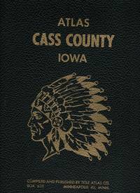
196539365Title Atlas Co. Very Good. 1965. 1st Edition. Spiral bound. Stiff card covers show mild wear a bit of marginalia. Approximately 100 pages total. Township maps show landowners directory includes names of spouse and children occupations etc. illustrated with numerous photographs.; MCN32439; Folio 13" - 23" tall . Title Atlas Co. unknown
1899867341899. ATLAS. ATLAS OF DORCHESTER WEST ROXBURY AND BRIGHTON CITY OF BOSTON in one volume. Boston: L. J. Richards 1899. Folio. 22" Street index plus 40 double page maps measuring 32" x 22". Bound in 1/2 leather which is largely absent. Front board is detached. Interiors are clean and free from staining with the exception of some light red or graphite pencil annotations on a few plates and soiled end-papers. Plates with pencil annotations: 28 29 30 37 39. Maps printed in as many as seven colors. A good copy. unknown
3030919935-VGUsed - Very Good. Very Good Condition! Crisp copy with a sturdy binding and light shelf wear. May have minimal notes or highlighting. Very Good Condition! Crisp copy with a sturdy binding and light shelf wear. May have minimal notes or highlighting. unknown
3030919935-GUsed - Good. A Good Used Book has a good binding with some shelf wear. May have minimal notes or highlighting. A Good Used Book has a good binding with some shelf wear. May have minimal notes or highlighting. unknown
1977324203Title Atlas Company 1977. Trade Paperback -- Spiral Bound -- Folio - over 12" - 15" tall -- Very Good -- Clean and tight with only lightest of wear. Containing Maps Plats of the Townships Rural Directory Pictures of Farms and Families Articles about History Etc. Trade Paperback. Very Good. Folio - over 12" - 15" tall. Title Atlas Company Paperback
196643325Standard Atlas Co. Very Good. 1966. Spiral bound. Brown stiff covers rubbed with moderate edge wear first few pages only have thin dampstain lower edge does not impact maps or text. Township maps show landowners with index of rural residents alphabetical directory listing family members occupation plus church histories numerous historical photographs. ; MCN35682; Folio 13" - 23" tall . Standard Atlas Co. unknown
0471874345.Gpaperback. Good. Access codes and supplements are not guaranteed with used items. May be an ex-library book. paperback
95253701Beijing 1980 Science Press. Tan boards very good 174p. 286 color photos 56 maps 2 ep maps pictorial d.j. SUBTITLE: cont. Academy of Sciences. A positively fascinating compilation of paleoanthropological research in China detailing the human fossils & paleolithic stone artifacts discovered in China over a 50-year period. Includes photos and discussion of human and animal fossils stone artifacts bone implements ornaments and traces of the use of fire. The maps show the distribution of major sites of various fossil and artifact findings paintings that depict the life and work of primitive man give the reader a fuller sense of the society and environment of an- cient cultures. unknown
1896867391896. ATLAS. ATLAS OF THE CITY OF BOSTON VOLUME 6 WEST ROXBURY. Philadelphia: G. W. Bromley and Co. 1896. Second edition. Folio 22.5". Contains street index outline and index map and 30 double-page maps measuring 22.5" by 32". Maps have only minor soiling to margins and occasional pencil annotations plates 1 and 27. FFEP and title page have large chips. Bound in half leather now mostly chipping or absent. In need of rebacking front board detatched. unknown
1890867351890. ATLAS. ATLAS OF THE CITY OF BOSTON Vol. 7 BRIGHTON MASS. Philadelphia: G. W. Bromley & Co. 1890. Folio. 22" Contains 30 double page maps - outline and index map and 29 plates - measuring 32" x 22" with only slight marginal staining near spine at head. Maps are drawn at scale of either 600 100 or 150 ft/inch. Bound in 1/2 leather missing much of leather covering and has detached and chipped FFEP. Front hinge very weak. unknown
1899867361899. ATLAS. ATLAS OF THE CITY OF BOSTON: SOUTH BOSTON. Philadelphia: G. W. Bromley Co. 1899. Folio 23". Street index and 33 double-page maps - outline and index map and 32 plates - measuring 32.5" x 22.5". Ffep missing. Outline and index map has tear near bottom where sheet folds. Plate 1 partly detached. Plates 29 30 31 are detached. Plates 2 and 32 have pencil annotations. Bound in 1/2 leather which is flaking. Interiors are bright some soil. Good. unknown
1906867321906. ATLAS. ATLAS OF THE TOWNS OF REVERE AND WINTHROP SUFFOLK COUNTY MASS. Boston: Whitman & Howard 1906. Folio. 22". Double page maps measure 32" by 22". All plans are drawn to a scale of 150 feet to one inch except index map. Includes street index outline and index map and 25 double-page maps. Interiors are in good condition with some light staining throughout at head and spine pencil or ink annotations to title page and plates 3 4 5 8. Exteriors are fair with heavily worn half-leather with black cloth boards and gilt-stamped edges. A good copy. unknown
1896867401896. ATLAS. ATLAS OF THE CITY OF CHELSEA AND THE TOWNS OF REVERE & WINTHROP MASS. Philadelphia: G. W. Bromley and Co. 1896. Folio 22.5". Contains street index outline and index map and 22 double-page maps measuring 22.5" by 32". Maps have only minor soiling to margins and occasional pencil annotations plates 12 17 18 21 and 22. Bound in half leather now mostly chipping or absent. In need of rebacking front board detached. As is. unknown
187354200Chicago IL: Warner & Beers 62 & 64 Lake Street 1873. Atlas folio. 16 x 18.7 in. 3 3 5-91 1 pp. Woodcut-engraved title page 42 hand-coloured steel-engraved maps all w/ nicely executed engraved borders couple double-page additional steel-engraved “Family Records†page filled-out in manuscript inserted. Original front panel stamped in decorative gilt lettering mounted on recent black cloth binding occasional edgewear minor soiling to fore-edges of textblock couple very minor closed tears still VG copy from the library of John Inkster 1828-1908 Scottish-American farmer who immigrated in 1860 to Pilot Township Kankakee IL to farm with his brother James and then continued West to farm in Coast Fork Lane Co. Oregon and finally the Washington Territory in 1881 where he homesteaded near Davenport WT assisted in building Fort Spokane and served as County Commissioner from 1886-1892. First edition of this exceedingly scarce Illinois Atlas published just after the great Chicago Fire of 1871 featuring an unrecorded platt map of Pilot Township in Kankakee County Illinois showing all the properties and property owners in 1872. This atlas also features the Railway map of Illinois City Map of Chicago maps of all the Illinois Counties and large map of the United States. Of special interest are the excellent early western maps of Texas; Minnesota Nebraska and the Dakota Territory; Wyoming Montana and Idaho Territories; Nevada and California along with map of Oregon and Washington and Alaska Territories. The Beers and Warners were successful map publishers in Chicago IL from about 1850 to 1886 and often publishing as Warner & Beers the cartographers produced a series of early state and county atlases and regional maps which were considered the most detailed maps produced at the time of the respective regions. As their Township and County maps often detailed individual homes and landowners they provide invaluable reference tools to researchers historians and genealogists. No copies located of this specific Warner & Beers Atlas in Worldcat; No individual copies located of the Pilot Township Map; See: Portrait & Biographical Record of Kankakee County Illinois 1893 pp. 390-391; An Illustrated History of the Big Bend Country embracing Lincoln Douglas Adams & Franklin Counties 1904 pp. 421-425. Warner & Beers, 62 & 64 Lake Street, hardcover
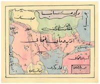
1910ABC_47241Ottoman Empire 1910. Gold-stamped cloth with the tughra of Mehmed V ruled 1908-18 on the front board when reading right to left and "Album" on the back board the front when reading left to right with an inscription below the tughra and the European numerals 16 and 2 flanking an ornament below the inscription the whole framed by 4 large floral cornerpieces. Oblong 4to 26.5 x 19.5 cm. 14 leaves with 10 pen-and-ink maps hand coloured with watercolours. Tissue guards. An album of hand-drawn maps forming an atlas of the western mostly European parts of the Ottoman Empire with legends in Ottoman Turkish written in the Arabic script. The overview map shows Albania Kosovo Macedonia and the Ottoman controlled northern parts of Greece coloured together with Thrace and the northwest parts of Anatolia shown treating them as a single unit while Serbia and Bulgaria like the small parts of territories outside Ottoman control are coloured separately. Most of the other maps give more detailed views of some of these regions including the Bosporus the Dardanelles Halkidiki Chalcidice Albania etc. but there is also a map of Crete not in the overview map.In fine condition. hardcover
0843711809.Ghardcover. Good. Access codes and supplements are not guaranteed with used items. May be an ex-library book. hardcover
GOR013803725Paperback. Very Good. paperback
0843711809New. hardcover. New. Satisfaction Guaranteed or your money back. hardcover
0843709553New. paperback. New. Satisfaction Guaranteed or your money back. paperback
#[37918]Rand McNally & Company 1994. Large folio. Original boards with dustjacket. With numerous coloured maps. hardcover
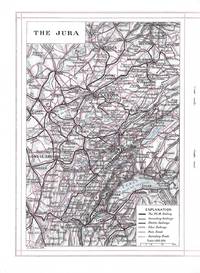
8371Paris: J. Barreau Imp. Edit.; Paris Lyons and Mediterranean Railway No Date. Quarto-sized booklet stapled in wrappers 26.5 x 19 cm. 19 1 pages. Illustrated with two maps in black and red and with two color plates and many black and white illustrations in the text. The text is a review of towns and cities in the Jura and Burgundy with small inset photographic images of famous buildings in each. In illustrated beige wrappers decorated and titled in dark green burgundy and gilt. Fine. J. Barreau, Imp. Edit.; Paris, Lyons and Mediterranean Railway unknown
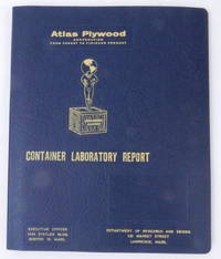
195627405Boston 16 Mass: Atlas Plywood Corporation 1956. Boards. Near Fine. 9 1/2 x 11 3/8 inches dimensions of tabbed loose leaf binder. Fourteen 8 x 10 inch approximate photographs plus "title page" photograph. Boards. A loose leaf binder with photographs depicting testing of crates and the attendant necessary equipment. Photos show a "large revolving drum" construction shop a compression machine what looks like a drop test chassis with crate affixed two photos of several men in a laboratory using a microscope and several other instruments a blueprint in progress two closeup images of instruments including a mullen tester a very large press used to compress pieces of plywood together testing in action and several other images. No doubt used as a sales tool demonstrating how thoroughly the company could build and test crates for reliable performance.<br /> <br /> The tenth edition of Industrial Research Laboratories of the United States 1956 locates the Atlas Plywood Corporation's Department of Research and Design at 431 Market Street Lawrence Mass. the same address as on the card cover of this folder hence our approximate dating. Atlas Plywood Corporation unknown
184618561Folio. Bound in one cont. hcalf. gilt back. Back slightly rubbed. With 3266 fine steel-engraved maps made and drawn by Duvotenay and Defour. 2 maps handcoloured a few brownspots mostly marginal. unknown