The Home Knowledge AtlasBiblio.com
990 résultats
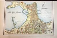
1888M5504Toronto: Home Knowledge Association 1888. Very Good upper margin trimmed closely. Notes: Detailed Map of Alexandria Egypt nicely hand coloured.<br>Alexandria is Egypt's principal seaport the second largest city after Cairo and the largest city on the Mediterranean coast. Founded in 331 BC by Alexander the Great Alexandria is one of the largest and most important cities of antiquity and a leading centre for science culture and scholarship. It’s nicknamed the "Bride of the Mediterranean" and "Pearl of the Mediterranean Coast". Size : 170x240 mm 6.75x9.5 Inches Coloring: Printed in Color with some hand colouring Category: Maps City Maps; Maps Africa North Egypt Home Knowledge Association unknown
2742710388.Gpaperback. Good. Access codes and supplements are not guaranteed with used items. May be an ex-library book. paperback
2742701370.Gpaperback. Good. Access codes and supplements are not guaranteed with used items. May be an ex-library book. paperback
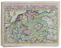
173017253Haarlem 1730. Small 8vo 16 x 10 cm. Bernardus Cleynhens Half textured red cloth ca. 1860 sewn on 2 tapes chemical-marbled sides in brown and blue. With 25 double-page engraved maps 2 overview maps the second serving as a key to the 23 numbered detail maps and an engraved plate with 8 scales all hand-coloured partly in outline. The 2 overview maps slightly wider than the others have a flap folded in at each side. Further with 1 rococo woodcut tailpiece 1 woodcut decorated initial and a fleuron on the title-page. 40 23 1 blank pp. plus maps and plate of scales. A surprisingly rare pocket atlas illustrating the theatre of the "tegenwoordigen" present war probably meaning the War of the Austrian Succession 1740-1748 but possibly the Seven Years' War 1756-1763. The title-page notes that it is suited for officers travellers and lovers of geography to carry in a pocket. The text in Dutch gives a geographic description only of "Duytsland" Germany including Austria Bohemia and a few other areas whereas the maps also cover the Low Countries the English Channel northwest France and to the east as far as Warsaw Krakow and Belgrade. The 23 detail maps were designed so that they could be assembled with the key map to make a single wall map whose cartographic image would measure 53 x 90 cm.With a contemporary owner's bookplate embossed stamp and library labels. With the text leaves somewhat browned not affecting the maps or the plate with scales and the first 2 leaves slightly worn but generally in good condition. A rare pocket atlas from the War of the Spanish Succession.l Koeman I Cle 1; STCN 2 copies; WorldCat 2 copies. hardcover
GOR007052644Hardback. Very Good. hardcover
0749529768.Gpaperback. Good. Access codes and supplements are not guaranteed with used items. May be an ex-library book. paperback
1971742635PN. New. 1971. Soft Cover. Date is original print. This is a reprint edition. . PN paperback
1527806065.Gpaperback. Good. Access codes and supplements are not guaranteed with used items. May be an ex-library book. paperback
1790D19541London 1790. Twelfth Edition. Hardcover. Very Good. Thick quarto. 22 engraved maps after Thomas Kitchin georgrapher to the King. A colorful hodgepodge of a binding with parts contemporary and other bits newer. Contents typically toned. <br/><br/> hardcover
177851680Edinburgh and London 1778. Large 4to. 32 x 245 cm. Contemp. hcalf. Raised bands. Title-label with gilt lettering. Top of spine lacks ca. 1 cm. of leather bottom of spine ca. 1/2 cm. Spine rubbed wear along hinges. Old owner inscription on top of title-page. Ex Libris Scholae Regis Edinensis. Engraved title-page and 23 double-page numb. 1-23 and all with original handcolouring. The map of the world 2 hemispheres: printed size 25 x 46 cm. sheet: 31 x 485 cm. Printed on heavy paper verso blank all clean and fine. <br/><br/><em>First edition. Not in Shirley. The copy described by Shirley I T.YOU - 1 a having another imprint dated 1782. All the maps in our copy is signed "Published as the Act directs 1st July 1778". Shirley mentions that the Atlas was doubtless intended for educational use. </em> hardcover
0265874890.Ghardcover. Good. Access codes and supplements are not guaranteed with used items. May be an ex-library book. hardcover
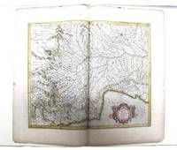
085473N: N 1985. Pp. viii242colophon blank pictorial title page printed in red & black 5 decorative initials printed in red black & white pictorial or decorative tailpieces pictorial endpapers notes bibliography; med. folio; qr. vein-patterned vellum spine lettered in gilt grey papered boards decorated in gilt; fore and bottom edges uncut; within black cloth slipcase which is a trifle marked; Stone & Lorson Fullerton California 1985. Edition limited to 115 copies; this one of 89 thus bound. Hamel 186. The hand coloured double page map tipped-in at the centre shows Pede Montana regio cum Genvensium territorio part of modern Italy. The French text on the reverse includes a large decorative initial and is lightly foxed. The leaf is from the 1619 French edition of Mercator's World Atlas which was the fourteenth edition of the celebrated cartographer's magnus opus. Parts of the atlas had been printed during Mercator's lifetime but the entire work was not published until a couple of years after his death in 1594. N unknown
No authorIn Pristine Condition. unknown
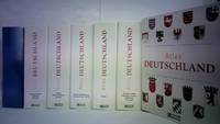
5h2316Atlas Verlag Lausanne 2006. Je Ordner ca. 200 Sammelkarten in original Verlags-Ringbuchordnern quart mit Rückenschildchen versehen. - gute Exemplare / Inhalt: Bayern / Rheinland-Pfalz / Thüringen / Saarland / Sachsen / Hessen / Niedersachsen - Bremen / Baden-Württemberg / Brandenburg - Berlin / Mecklenburg-Vorpommern / Nordrhein-Westfalen / Sachsen-Anhalt / Schleswig-Holstein - Hamburg / unkollationiert / Anbei: Mitteleuropa - unknown
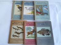
2d13765J.F. Schreiber Verlag Esslingen und München um 1920. Je Heft ca. 24 S. mit zahlr. Farbdrucktafeln und zahlr. naturgetreuen Abbildungen kartoniert teils leicht fleckig. - enthalten: Schreibers kleiner Atlas der Kriechtier und Lurche/der Säugetiere/fremdländischer Vögel Heft 1 und 2/der Schmetterlinge und Raupen/der Fische - unknown
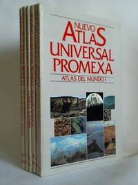
5g346Ediciones Nauta S. A. Barcelona 1984. Je Band 112 S. mit vielen Abbildungen und Kartenskizzen Pappbände folio Einbandkanten teils gering bestoßen. - Enthalten: Band 1: Atlas del Mundo I / Band 2: La Tierra I - Geografia Fisica / Band 3: Atlas del Mundo II / Band 4: La Tierra II - El Hombre y la Actividad Economica / Band 5: Atlas de México / Band 6: Atlas de América - Indices / Text spanisch - unknown
5L764Atlas Verlag Stuttgart 1999. Ca. 300 Sammelblätter mit vielen Abbildungen in 3 original Pappringbuch-Ordnern quart. - gute Exemplare / nicht kollationiert / Beinhalten: Grossbritannien und Irland / Italien und Malta / Südosteuropa / Deutschland / Frankreich / Nordeuropa und Nordosteuropa / Niederlande Belgien und Luxemburg / Ostmitteleuropa und Osteuropa / Österreich Schweiz und Liechtenstein / Spanien und Portugal - unknown
2013x-1439880212CRC Pr I Llc 2013. Hardcover. New. 2nd edition. 916 pages. 10.00x7.00x2.00 inches. CRC Pr I Llc hardcover
18781189-nnew. unknown
18781189like new. unknown
2013SKU1754888CRC Press 2013-06-25. hardcover. New. 7x2x10. New Book Ships with Tracking CRC Press hardcover
1420068075.Ghardcover. Good. Access codes and supplements are not guaranteed with used items. May be an ex-library book. hardcover
2013SKU0206587CRC Press 2013-06-25. Hardcover. Good. Textbook May Have Highlights Notes and/or Underlining BOOK ONLY-NO ACCESS CODE NO CD Ships with Tracking CRC Press hardcover
2013DADAX1439880212CRC Press 2013-06-25. 2. hardcover. New. 2.01x7.01x10.00. Buy with confidence. Excellent Customer Service & Return policy. CRC Press hardcover
2013SONG1439880212CRC Press 2013-06-25. 2. hardcover. Used: Good. 2.01x7.01x10.00. Buy with confidence. Excellent Customer Service & Return policy. CRC Press hardcover