4 996 résultats
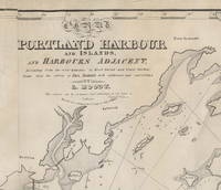
18283754<p><b>Important Early Chart of Portland Maine Harbor</b></p><p>Lemuel Moody 1767-1846 was an enterprising sea captain and nautical entrepreneur in Portland Maine. Realizing "the great necessity of a correct Chart of Portland Harbour and the dangerous Rocks near Cape Elizabeth also of Winter Harbour and the numerous islands in Casco Bay" Moody decided to produce such a chart. By 1825 the <i>Atlantic Neptune</i> charts that included this area were more than 50 years old and in need of updating. Moody took advantage of the opportunity and produced this chart using the <i>Atlantic Neptune</i> charts as the foundation. In a notation on the original agreement for producing the chart Moody states that "I did the whole of the survey." This impressive chart of Casco Bay was his sole cartographic undertaking. </p><p>The chart covers the area from Saco Bay to Seguin Island. A large inset at the upper left focuses on the immediate area around Portland harbor including a detailed layout of streets and wharves. Small drawings of several sailing ships decorate the chart. Of particular interest is one sailing vessel being towed by a steam-belching vessel southeast of Small Point an early record of steam-powered ships in Maine waters.</p><p>One of the prominent landmarks that Moody included on the chart is the Portland Observatory an 86' high tower that still stands atop Portland's Munjoy Hill. The Observatory one of Moody's entrepreneurial undertakings was built in 1807 and served as a marine signaling tower. Using a telescope from the tower and a flag-based signaling system Moody would – for an annual fee – alert ship owners of the arrival of their vessels well in advance of their arrival in the harbor.</p><p>The chart went through at least five states of which this is the second. The fortuitous survival of Moody's business records and the known construction dates of certain marine landmarks make it possible to identify the dates and production run of the various states of the chart with a fair degree of specificity. While all the charts produced include the initial publication date of 1825 in the title later states were known to have been printed in 1828 1832 1838 and 1857. The initial 1825/6 printing was 191 charts. For this second state only 49 charts were struck from the plates.</p><p>The second state is distinguished by the addition of two light towers that were constructed in Cape Elizabeth in 1828. Known now appropriately enough as "Two Lights" the two structures still stand though one has been decommissioned as a navigation aid. The updates to the copperplate and printing of this state were by Andrew Allen of Boston.</p><p>Moody's chart is very uncommon in any of its states. OCLC identifies three institutional holders as of September 2021: State Library of Massachusetts Osher Map Library and Boston Public Library. Additional examples are held at the Maine Historical Society Library of Congress Yale and at least one private collector. No examples of the chart were identified in the <i>Antique Map Price Record</i> during its run from 1983 to 2011.</p><p>A very attractive example of an important and scarce early Maine chart.</p><p><b>Reference</b>: Phillips <i>A List of Maps of the United States</i>: p. 717 Mistakenly titled as Map of Portland Harbour and Islands…</p><p><b>Acknowledgment:</b> I am indebted to Ms. Frances Pollitt formerly of the Maine Historical Society for sharing her research on the dating and production of Moody's chart.</p><b>Condition: </b>Lined on reverse mending several tears. Very minor recreation of image loss and restoration of blank margin areas.<p>ICN 7690.3.</p> [Lemuel Moody.] .] Engd by D. G. Johnson. Entered According to Act of Congress July 13th, 1825. [but 1828.]
1769702 ouvrages en 1 vol. in-8, demi-basane bleue, dos lisse orné de filets à froid, premiers plats de couverture conservés (reliure de l'époque). Reliure légt frottée. Coins usés.
234793Le Mans, Chaudourne, 1920 in-8, 48 pp., broché, couverture rempliée.
2003LFA-126733106Revue spécialisée dans les camions anciens : 82 pages, format 210 x 295 mm, illustrée, brochée couverture couleurs, bon état
2003LFA-126733107Revue spécialisée dans les camions anciens : 82 pages, format 210 x 295 mm, illustrée, brochée couverture couleurs, bon état
207494Mamers, Fleury et Dangin, 1886 in-4, VIII-355 pp., frontispice, 4 planches, nbses ill. in-t., bradel papier marbré, couv. cons. (reliure moderne).
237566Mamers, Fleury et Dangin, 1886 in-4, VIII-355 pp., frontispice, 4 planches, nbses ill. in-t., bradel papier marbré, couv. cons. (reliure moderne).
201106751Paris, Editions alpina, 1931 ; grand in-8, 155 pp., broché, couverture illustr.
201907431Paris, France loisirs, 1996 ; grand in-4, 159 pp., cartonnage de l'éditeur.
102997Mamers, 19 fructidor an 7 (5 sept. 1799), in-folio, 2 pp.,
102998Mamers, 19 fructidor an 7 (5 sept. 1799), in-folio, 2 pp. 1/3,
102328Mamers, 12 brumaire an 8, 3 nov.-1799 2 p. in-4 (28 x 21 cm.),
102325Saint Come, le 11 brumaire an 8, 2 nov.-1799 2 pp. in-4,
102321Marolles, le 7 frimaire an 5, 27 nov.-1796 4 pp. in-4,
N°1-2, de janvier-juin 1994, 4è série, tome CXV de la série générale de cette revue trimestrielle fondée en 1900 par Henri Berr, consacré à la "Classification des sciences": "A travers des exemples empruntés soit aux grandes classifications ("Encyclopédie", "Cours de philosophie positive"), soit à des domaines particuliers (physique, chimie, histoire naturelle, etc), les études rassemblées ici s'inscrivent au point de confluence entre systèmes philosophiques de classification des sciences et institutionnalisation des disciplines, conjugués pour définir une hiérarchie des sciences et, au-delà, les traditions culturelles d'un pays" (4è de couverture). Français
199418621Paris, Centre international de synthèse / Albin Michel, 1994 1 volume 15,5 x 23,4cm Broché. 314p. 3 feuillets. Très bon état.
2003LFA-126745099N° 198 Hors-série (2003) 32 pages, format 215 x 285 mm, illustré, broché couverture couleurs, bon état
2002LFA-126711613Numéro Spécial de la revue d'art "Connaissance des Arts" : 66 pages, format 215 x 285 mm, illustré, broché couverture couleurs, publié en 2002, bon état
240841Paris, Pierre-Guillaume Simon, 1775 in-4, 4 pp., en feuille.
232410Laval et Mayenne, 1896 4 vol. in-8, brochés.
95115Paris, Chez le Secrétaire Général, s.d. (1930) in-8, paginé 29 à 68, broché.
1883852751883 Lyon, Imprimerie de la Province, 1883, in 12 broché, 286 pages ; rares rousseurs ; couverture fanée.
204133Paris, Imprimerie Nationale, An VII in-8, 3 pp., dérelié.

