1 313 résultats
EN-153o.J. Öl auf Karton, auf Blendrahmen aufgezogen, links unten monogrammiert und datiert ?E·D·K 13·?. 48,5:58,5 cm. - Provenienz: Aus dem künstlerischen Nachlass. - Seltenes Frühwerk Kinzingers, das in der Zeit entstand, als er Meisterschüler von Adolf Hölzel war.
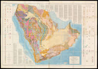
58310Washington D.C.: The US Geological Survey 1963. 129.5 x 185.5 cm. Original chromolithographed folding map laid onto new linen. Excellent condition. Large and detailed map depicting the geology of the Arabian Peninsula. The search for oil on the Peninsula started in 1933 when the Saudi Arabian government granted an oil concession to Standard Oil Co. of California which was later joined by Texaco buying a 50% stake in the concession. Geologists soon followed to start the surface mapping of the area and beyond achieving by 1937 a broad understanding of the region's geological strata. The first test to yield oil was in Dhahran on 4 March 1938. After a hiatus during WWII the activity of surveying and test-drilling resumed with reinvigorated effort. Aerial photography was introduced in 1949 and proved an invaluable tool for the surveying. In 1954 the US Geological Survey and Aramco the Arabian American Oil Company began work on a series of geological and geographic maps which would incorporate the data collected over the years. The project was sponsored by the US Department of State and the Kingdom of Saudi Arabia. The effort resulted in 1:500000-scale geologic sheets and a 1:200000-scale geological map of the Arabian Peninsula and the base topographical map — the present maps. The geological map delineates the strata of the peninsula with colour codes in two tables on either sides and text within the blank regions of Eastern Africa and Iran. A paper to accompany the map and further explain the geology was published in 1966 by the US Geological Survey. Powers Ramirez Redmond Elberg Geology of the Arabian Peninsula Sedimentary Geology of Saudi Arabia U.S. Geological Survey Professional Paper 1966. Washington, D.C.: The US Geological Survey, 1963. unknown
EN-130o.J. Öl auf Leinwand, um 1920, auf Keilrahmen, unsigniert. 50:40 cm.- Randdoubliert, mit restaurierter Fehlstelle im Bereich der Kopfbedeckung. Auf dem Keilrahmen bezeichnet ?Model Frau Tillmann? und ?Portrait Ruth?. Provenienz: Privatsammlung, Köln. Literatur: Ausstellungskatalog: August Sander und die Kunstszene der 20er Jahre im Rheinland, Köln, Josef-Haubrich-Kunsthalle und Kunsthalle zu Kiel, 2000, Kat. Nr. 283, Abb. 91, S. 85. - Abelen porträtierte Frau Tillmann mit ihrem von einer Lederkappe verdecktem Kurzhaarschnitt und Felljacke möglicherweise als Pilotin eines offenen Automobils, unbedingt aber als emanzipierte Frau der Weimarer Republik.
1931ABC_46004Greece Palestine Iran Iraq Egypt 1931. Oblong photograph album 20.5 x 32 cm. With 72 sepia photographs ca. 6 x 8.5 cm. Album of personal photographs commemorating a journey in 1931-1932 to the oilfields in modern Iran and Iraq by a trio of travellers which included the Reverend Philip "Tubby" Clayton 1885-1972 the founder of the Toc H movement. Several photographs show Galilee Jerusalem Rutbah Wells Ar-Rutbah and about 10 show "fields" mostly the main oilfield at Masjed Soleyman and its gas separator.In 1931 Clayton was invited by the director of the Anglo-Persian Oil Company the predecessor of the British Petroleum Company "to inspect the work among the Company units in Persia and the Middle East generally" Harcourt. Accompanied by two friends he travelled by plane train and boat to Lake Tiberias and further by plane to Rutbah Wells a British airfield where the group spent Christmas Eve with British Dutch and German travellers. On Christmas Day they reached Abadan and from there visited the oilfields near Tehran Ahvaz Haftkel Mohammerah Basra and Masjed Soleyman. After a journey to Cairo and Alexandria they boarded an oil tanker for the return journey to Britain. This journey inspired Clayton to plead passionately for improvements to the life of the crews of oil tankers. He described "carrying oil by sea" as "the most lonely job on the world's waters" Clayton. In 1940 he became chaplain of Anglo-Saxon Petroleum's tanker fleet and would subsequently sail on multiple tankers.The photographs must have been taken by Henry Pegg Chappell 1909-1997 since the other members appear he is the only member not present in the photographs and he does not and only Clayton who completed the journey by oil tanker. A carbon copy of a typed list describing all photographs is inserted in the album. Since typed and handwritten additions to the carbon paper refer to Clayton in the third person he probably typed the original list and gave Chappell this carbon copy to insert in his album.With an inscription probably by the three travellers on the title page. Binding slightly worn at the extremities. Paperclip and staple on the typescript rusted. In very good condition.l Clayton "In a tanker" in: The Times 9 March 1932 p. 15; Harcourt The impudent dreamer pp. 216-219. unknown
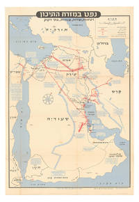
1957ABC_46260Tel Aviv: Israel Defence Forces General Staff 1957. Folded. 56 x 82.5 cm. Chromolithographic map of the Arabian Peninsula from Turkey in the north to the Indian Ocean in the south and covering Saudi Arabia Egypt Israel Palestine Jordan Syria Lebanon Iraq Iran Kuwait Bahrain Qatar United Arab Emirates Oman North and South Yemen. Scale 1:5000000. Scale and key in Hebrew inset to top-right inset explanatory panels in Hebrew and English compass rose in Saudi Arabia. Extremely rare Israeli strategic map of the Arabian Peninsula showing oilfields and associated infrastructure. Printed in black red and blue the map demarks the political boundaries of the time along with the areas covered by oil companies concessions. Pipelines form a web across the northern part of the Arabian Peninsula shown in an uncommon vertical orientation while oilfields and refineries large and small are also marked. The IDF probably made the map in responce to the 1956 Suez Crisis and its associated geopolitical shifts. With the Egyptians operating the Suez Canal and the USA forcing Britain and France to abandon their post-imperial plans Israel now counted in both U.S. and Soviet plans for their control of Middle Eastern politics. Britain had to anchor its Middle Eastern influence in Cyprus Aden and Iraq while the increased American influence can be seen in the huge swathe of territory assigned to Aramco. We have located only one institutional copy of this map in the National library of Israel.With traces of pins from former wall mounting. A couple of small light stains some uneven creasing and tears at the edges of some folds and a couple tiny holes where the folds cross. Otherwise in good condition. Israel Defence Forces, General Staff, unknown
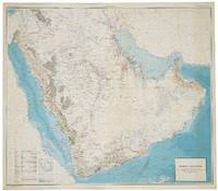
56801Washington D.C.: Department of the Interior United States Geological Survey and the Kingdom of Saudi Arabia Ministry of Finance 1963. SECOND EDITION ENGLISH ISSUE. Large chromolithohraphed map 122 x 139 cm of the Arabian peninsula shown with topographic relief and marked with water pipelines oases oil fields oil pipelines ports and harbours oil wells natural gas fields quarries and mines. Key lower left. The map includes the territories of modern day Kuwait Qatar Bahrain United Arab Emirates Oman and Yemen and was the work of a team lead by the distinguished geologist Glen F. Brown whose pioneering work on surface geology with its emphasis on water resources minerals and oil pertains to this day. Minor light spotting lower right generally in excellent condition. Issued simultaneously in an English and Arabic versions. Originally conceived in 1953 this second edition shows significant additional topographical detail and noticeably showing the growth in oil fields and accompanying infrastructure. Brown 1911-2001 began his career conducting coal investigations in South China and the Philippines and ground water investigations in Mississippi and Colorado the latter mostly concerned with supplying water to military installations. In response to a request from Ibn Sa'ud for assistance from the United States Geological Survey USGS Brown was selected in 1944 to investigate water supplies in the Saudi Arabian desert. Brown "arrived in Saudi Arabia early in 1945 and joined a mission sponsored by the US Foreign Economic Administration to study possibilities for agricultural development in central Arabia. As part of the mission he carried out a detailed investigation of the geologic formations in the Al Kharj district and identified substantial ground-water resources in buried aquifers. His report on the results of that investigation was very enthusiastically received by Saudi officials. Brown returned to Saudi Arabia at the request of Ibn Saud to conduct reconnaissance geologic mapping mineral evaluation and water-resource studies in the western and central parts of the kingdom. The mapping was carried forward from 1950 to 1958 by Brown with USGS and Saudi associates and extended to the entire Arabian Peninsula in cooperation with the Arabian American Oil Company Aramco as well as to organizations and companies of other countries in the peninsula. This resulted in a remarkable series of bilingual geologic and geographic maps of Saudi Arabia at a scale of 1:500000 and a geologic and geographic map of the entire Arabian Peninsula at a scale of 1:2000000 all of which were published by the USGS. These maps together with reports on the geology mineral deposits and water resources prepared by Brown and his associates providing the basis for Saudi Arabia to undertake a major national resource exploration and development program" obituary Geological Society of America. The map includes the territories of modern day Kuwait Qatar Bahrain United Arab Emirates Oman and Yemen. Although the hunt for oil gas and minerals ultimately drove geological survey work across the region in its early years it was the need for continual water sources which was the catalyst for Saudi Arabia's resource exploration. In 1944 King 'Abd al-'Aziz approached the United States for a technical expert who could assist with the identification and plotting of the kingdom's natural resources particularly its groundwater reserves. Glen F. Brown who undertook the task and is responsible for this map was one of the pioneers of a partnership between the United States Geological Survey USGS and the government of Saudi Arabia. This collaboration was one of international importance spanning the next five decades and influencing the development of the kingdom significantly. By 1954 the Saudi Ministry of Finance United States Geological Survey USGS and Aramco were working together to produce the first full series of geographic and geologic maps of the country. The first of their type in the Peninsula were published between the late 1950s and early 1960s in both Arabic and English copies. The information these maps contained formed the basis of subsequent Saudi national development plans. To this day all modern maps of the kingdom trace their roots back to these publications. Washington D.C.: Department of the Interior, United States Geological Survey and the Kingdom of Saudi Arabia Ministry of Finance unknown
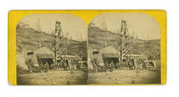
1866235961Titusville: J.A. Mather 1866. 22 stereo cards with printed paper labels on verso titled in manuscript. 3-1/4 x 6-3/4 inches. Some wear to cards images near fine. 22 stereo cards with printed paper labels on verso titled in manuscript. 3-1/4 x 6-3/4 inches. A fascinating and important record of the birth of the oil industry in northwestern Pennsylvania.<br/><br/>British-born John Aked Mather 1829-1915 moved to the United States in 1856 and soon after was introduced to photography by an itinerant daguerreian. Mather travelled through West Virginia and Ohio before settling in Titusville Pa in 1860 with his wife. Edwin Drake of the Seneca Oil Company had begun drilling in August of 1859 and Mather was poised to become the oil boom's photographer of record travelling along Oil Creek River on his flatbed studio. Mather's views of wells and rigs were so popular in their time that owners would request Mather photograph their operations to encourage more investment. <br/><br/>The photographs that Mather took make up the largest and most significant pictorial record of the western Pennsylvania oil boom "a record of the first ten years of the industry a coverage without equal in any nineteenth century technology" Darrah The World of Stereographs p. 80. Notably these stereoviews are contemporary to the boom and thus more desirable than Mather's Historical Oil Region Views published in 1895 from the original negatives.<br/><br/>This group of 22 stereo views includes "Oil Seekers Pithole Penn" "Green Mountain Well " "Champion Wells Pioneer River" "RR Bridge & Pioneer from Oil Creek" "New York Well Pioneer" "Lady Stewart & Lady Brooks Pioneer River" "Petroleum Center Penn" "Fishers Shipping Sheds" "Old Shipping Platform Miller Farms" and the humorous "Sunken Fortune or Ruined Man"<br/><br/>See Giddens Paul H. Early Days of Oil: A Pictorial History of the Beginnings of the Industry in Pennsylvania Princeton: 1948. J.A. Mather unknown books
187383Abu Dhabi: 1987. Geology and oil fields A rare set of large blueprints produced by the Abu Dhabi National Oil Co. ADNOC with stratigraphic cross-sections of the Habshan formation in the Thamama Group in western and central Abu Dhabi. We have traced no other similar blueprints institutionally or on the market. Issued by the ADNOC geologists Abdullah al-Habshi and Mohammed M. Abd al-Sattar in May 1987 the blueprints provided the results of experiments in the gamma ray porosity correlation of the Habshan formation in order to clarify the rock type and composition of onshore and offshore oil fields including Umm Salsal West Mubarras Zakum Abu al-Bukoosh Bab and Sahil. While Abu Dhabi's oil production had slowed down markedly during the 1980s the reorganization of ADNOC in 1988 and the start of the Gulf War in 1990 prompted a sharp increase in output particularly in the areas covered by these blueprints. Nine blueprints from 130 x 40 mm to 233 x 40 mm folding into 285 x 200 mm numbered 1-9 sequentially. Small inset maps to folded verso c.10 vertical charts per map. Text in English occasional Arabic. Preserved in archival box. Inset map highlighted in ink. Occasional slight marginal soiling or small tears at folds: very good copies. unknown
65872Saudi Arabia 1955 - 1960. 43 silver gelatin press photographs of Saudi Arabia particularly of the workers and possessions of the Arab American Oil Company. 40 measure 25.5 x 20.5 cm 2 measure 21.5 x 16.5 cm and 1 measures 23 x 18 cm; 32 prints stamped by Aramco with 8 evidently also produced by the company 2 by Keystone Pictures Inc. and one by Wide World Photo; 18 photographs are accompanied by descriptions. Some creasing to corners one print with small tears to the top and left edge. In excellent condition overall. The Arabian American Oil Company also known as Aramco emerged from US efforts to extract and refine crude oil in the Arabian Peninsula. The California-Arabian Standard Oil Company discovered oil at Dhahran in 1937 which was extracted at a rate of 115 barrels a day. This became the first commercial well in Saudi Arabia and was a breakthrough for American Oilmen looking for reservoirs of 'black gold' overseas. In 1944 the company changed its name to the Arabian American Oil Company. These photographs were almost all taken by Aramco to showcase the company's logistical and mechanical achievements as well as the care it took of its workforce. Many of the photos were circulated in the Aramco World Magazine and Sun and Flare internal company magazines that were generally intended to boost the company's corporate identity as well as improve relations with the Saudi world around them. Contents include: Aramco hardware drill; pipes and coating machine for the trans-Arabian pipeline; stabilising plant at Dhahran; Aramco employees at work Saudi employees filling tank car; Saudi employee operating temperature gauge; Aramco employee towns and living quarters senior staff housing in Abqaiq; Aramco houses at Rahimah near Ras Tanura; various aerial views probably of Dhahran; Saudi townscapes and vernacular buildings school in Hofuf; market at Hofuf; Riyadh old town; etc.; American and Saudi employee recreations boat trip to Tarout Island; American wives shopping; swimming pool at Dhahran etc.; portraits and posed photographs 'Qidaith ibn Mubarak … Starting as a laborer he advances to the position of assistant driller'. In addition the collection includes two portraits of King Saud bin Abdulaziz. This is a fascinating set of photographs documenting the early days of US-Saudi relations and a key moment in modern oil production. Saudi Arabia, [1955 - 1960]. unknown
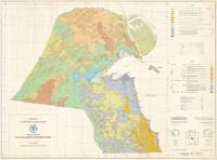
654341981. Original large colour-printed map 76 x 103.5 cm with detailed key and legend. Compilation and cartography by Hunting Geology and Geophysics Limited. Generally in excellent condition. Kuwait becomes a Major Player in the Global Oil Industry This is a scarce large-format bilingual geological map of Kuwait prepared in 1981 by Hunting Geology and Geophysics for the Kuwait Oil Company. It was produced at a time when Kuwait's oil production was undergoing rapid changes including the creation of the Kuwait Petroleum Corporation KPC of which the Kuwait Oil Company became a subsidiary and expansion into international markets and the securing of vertical integration. The map covers the mainland of Kuwait along with the Bubyan and Failaka Islands using colour-shading to indicate a variety of sands gravels clay and stone as explained in the bilingual legends present at right which also indicate geological era. Lines and other notation are used to indicate geological and international boundaries fault lines wadis elevation contour lines roads depressions and intertidal and shoaling sand. Developed areas namely Kuwait City and some nearby coastal settlements are shaded grey. Additional supplementary information appears at right including a diagram and explanation of the local grid employed. Historical Context Upon gaining independence from the United Kingdom in June 1961 Kuwait inherited an oil industry dominated by the Kuwait Oil Company KOC a joint venture between British Petroleum and Gulf Oil. However like other emerging postcolonial states in the region Kuwait was determined to assert control over its primary resources. This effort began with the formation of the Kuwait National Petroleum Company KNPC in 1960 and the Petrochemical Industries Company PIC in 1963 which allowed the government to build domestic technical expertise. A major milestone of this era was the 1962 relinquishment agreement which forced foreign concessionaires to return 60 percent of their unexplored territories to the state paving the way for independent national exploration and the 1968 opening of the Shuaiba Refinery the world's first all-hydrogen refinery. The 1970s saw a shift from foreign partnership to total nationalization following the 1973 oil crisis and the subsequent surge in global prices. After an initial 'participation' agreement in 1972 that gave the state a 25 percent stake in KOC Kuwait moved for a full takeover by December 1975. By 1976 the state held 100 percent ownership of its oil assets allowing it to cap production to conserve reserves for future generations a policy that stood in contrast to the high-extraction strategies of foreign firms who further increased production as they sensed nationalization was in the offing. Thus the vast revenues generated by the oil industry were funneled directly into the Reserve Fund for Future Generations established in 1976 to provide long-term fiscal stability. They also financed a comprehensive welfare state providing citizens with free education healthcare and subsidized housing while transforming the capital of Kuwait City simply 'Kuwait' here into a modern metropolis. By the early 1980s Kuwait shifted its focus toward global integration and organizational efficiency. In January 1980 the government established the Kuwait Petroleum Corporation KPC as a centralized holding company to manage all aspects of the industry from upstream exploration to downstream retail. Kuwait became a pioneer among OPEC nations by aggressively expanding into international markets acquiring the American drilling and engineering giant Santa Fe International in 1981. This strategy continued with the acquisition of refining and retail networks in Europe laying the groundwork for the 1983 launch of the 'Q8' brand. Thus by the mid-1980s Kuwait had successfully established one of the most vertically integrated and professionally managed state oil industries in the world. Publication History and Census This map was compiled and drawn by Hunting Geology and Geophysics for the Kuwait Oil Company. It is quite scarce noted only in the holdings of the Colorado School of Mines the U.S. Geological Survey Library and the Library of Congress with no known market history. Cartographer Hunting Geology and Geophysics Ltd. 1952 - 1987 was a British surveying firm that specialized in cutting-edge methods of mapping especially aeromagnetic surveys and focused on discovering potential reserves of natural resources especially fossil fuels. It was part of the larger Hunting group originally founded in 1874 as a shipping company by Charles Hunting and later moving into aircraft surveying and petroleum. Companies within the Hunting group frequently merged with each other and with outside acquisitions leading to frequent name changes; in this case Hunting Aerosurveys founded 1944 merged with Hunting Geophysics founded 1952 to form Hunting Surveys in 1960. In 1965 a public company was formed called Hunting Associated Industries Ltd. which included Hunting Surveys Holdings Ltd. but not a new entity Hunting Geology and Geophysics Ltd. which remained part of the privately-owned Hunting Group. In 1987 Hunting Geology and Geophysics Ltd. was closed down in a consolidation process that saw the public company now Hunting plc buy out the Hunting Group though the Hunting family retains a significant share of the company's stock and one of its members remains Chairman of the Board. Hunting Geophysics and later Hunting Geology and Geophysics Ltd. made pioneering surveys of Great Britain itself along with several countries in Central Africa seeking uranium and other minerals the Philippines Ethiopia and especially countries in the Middle East where the company conducted critically important surveys that helped to develop the lucrative oil industries of the United Arab Emirates Qatar and Kuwait among others. OCLC 9971094 1981. unknown
awd-832Huile sur toile monogrammée et datée (67) en orange en bas à droite, titrée et contresignée au dos (48/53 cm). Avec le numéro d’inventaire de la succession H. R. n°236). Voir Hans Richter par Roberto Sanesi, Nuova Foglio Editrice, 1978, où l’œuvre est reproduite (p. 128). Bon état.
9798Florence : Giunti, 1569. 4° bois sur la page de titre et deux grandes initiales gravées sur bois . 4 feuillets non chiffrés, 89 pp. Suivie d'une feuille vierge M6. vélin moderne dos orné, pièces de titre en maroquin rouge. Des passages ont été anciennement soulignés à la plume.
149-Wo.J. Öl, auf Papier, links unten ritzsigniert ?Ernestine von Lipowsky, geborene von Eder?, rechts unten bezeichnet ?Untersberg?. 13,7:19,6 cm. Nagellöchlein in den unteren Ecken. Minimaler Einriß links unten. Frische und dynamische, sicher vor Ort entstandene Landschaftsstudie, die eine intensive Beschäftigung mit der Münchner Freilichtmalerei erkennen läßt.
60397BBo.J. [4 Warenabbildungen] (Petra Petitpierre, geborene Frieda Kessinger, geboren am 13. Mai 1905 in Zürich, gestorben am 23. Dezember 1959 in Murt
186538685Philadelphia 1865. Broadside with a table of the rates of fare on verso. Woodcut illustration of a locomotive. Sheet size: 19 x 8 inches. Extraordinary survival: a railroad broadside advertising a route to America's first oil boom.<br/> <br/>The first oil well in the United States was drilled by E. L. Drake in Oil Creek Pennsylvania near Titusville in 1859. On the 29th of August oil was struck and the first boom was on. Towns such as Oil City and Pithole sprang up. The Titusville population exploded from 250 residents to over 10000 in little more than five years; Pithole expanded from four log-cabin farmhouses to a bustling city with over 50 hotels over the span of five months in 1865. At its peak the Pennsylvania wells were producing one third of the world's oil. An ephemeral survival of America's first oil rush. unknown books
730.1aafimage 45x55.5, cadre 57.5x67.5 cm
60145BBo.J. [3 Warenabbildungen] August Preuße, geboren am 22. März 1908 in Höhscheid, gestorben am 9. März 1942 in Russland. Nach einer Ausbildung an de
60398BBo.J. [3 Warenabbildungen] August Preuße, geboren am 22. März 1908 in Höhscheid, gestorben am 9. März 1942 in Russland. Nach einer Ausbildung an de
1952ABC_46142Al Ahmadi: Kuwait Oil Company 1952. Loose sheets stapled together at the left top corner with holes punched in the left margin. Small folio 33 x 20.5 cm. Duplicated typescript printed on the rectos only in purple ink probably with a spirit duplicator. Unrecorded information guide for new employees of the Kuwait Oil Company KOC who would be residing in Al Ahmadi headquarters of the Company. The Kuwait Oil Company was founded in 1934 a joint venture between the British Anglo-Persian Oil Company and the American company Gulf Oil. In the same year the sheik of Kuwait Ahmad Al-Jaber Al-Sabah reigned 1921-1950 granted them rights to the oil concession which they were to retain until 1975. The first oil was discovered in 1938 in Burgan field followed by discoveries in Magwa in 1951 Al Ahmadi in 1952 and many more regions. In 1946 the first commercial shipment took place. Because the initial development of the KOC coincided with the end of the British Raj in India many British and Indian people in its service were transferred to Kuwait in particular to Al Ahmadi. Al Ahmadi was set up to house these workers.This unrecorded guide is quite rare especially because it seems to be a quite cheaply produced and ephemeral document which was issued only in small numbers for in-house circulation.At some places very slightly frayed and creases along the edges and corners staple a little rusted leaves slightly toned some leaves a little cut short at the foot with no loss except for some of the catch-words but overall in remarkably good condition. A rare and unrecorded guide for employees of the Kuwait Oil Company in Ahmadi. Kuwait Oil Company, unknown
1337.1aaf50x68.5cm/cadre 55x73cm.
136265aaf1862, 35x42 cm., Oelmalerie signé et daté 1862 ( huile sur toile) / Oil on canvas. encadré / Gerahmt.
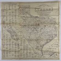
192012758Fort Worth: Standard Blue Print Map & Eng. Co 1920. Very good. Folding map 25.75 x 25.75 inches on thin paper. Old folds minor edge wear several short closed edge tears a couple of small areas of loss at crossfolds. Overall good condition and a wonderful display item. A rare and detailed Texas oil map produced by a Fort Worth firm just after World War I and here present in the larger 25-x-25-inch issue advertised in the promotional text on the map itself. The map shows the distribution of oil wells and derricks across the Lone Star State in 1920 prints the names of the most prominent oil fields and lists the names of Texas counties along with the oil companies active in each county. The map also shows the types of soil and rock deposits encountered throughout Texas counties with a legend of abbreviations for each at bottom right. The area of the map is crowded in places but still quite attractive and legible and is a good encapsulation of the rapidly developing oil industry in Texas at the time. Contemporary advertisements for the publisher of this map Standard Blue Print Map and Engineering promote the availability of over 200 oil maps of Texas Oklahoma New Mexico Louisiana and Arkansas from the firm. A rare map rarer still in this larger size; we locate just two copies at SMU one issued with a slightly later "May 1920" copyright notice with a larger "photocopy" reported at Denver Public Library and the Colorado School of Mines. Standard Blue Print Map & Eng. Co unknown
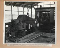
1943540Venezuela 1943. Very good. 48 original photographs each 8 x 10 inches. Quarto. Plain leather boards twin-bolt binding. Some photos detached from mounts some wear to covers but images generally fine with typed captions affixed beneath each photo. A rare photographic document of Venezuelan oil production in the early 20th century. This album contains nearly fifty large-format original images that depict the construction of a 157-mile crude oil pipeline from Las Mercedes Del Llano Guanico to a deep-sea terminal at Pamatacual in 1943 by the Sociedad Anonima Petrolera las Mercedes owned jointly by the Texas Company later Texaco and British-controlled Caracas Petroleum S. A. Venezuelan oil reserves attracted foreign investment as early as 1908: "In 1908 General Juan Vicente Gomez took power to become the strongest dictator of the 20th century with 27 years in office. He opened the gate to foreign oil investors.World War I was the trigger introducing Venezuela into the world oil market. After 1919 the investment and the exportation of Venezuelan oil increased tremendously. By 1922 Venezuela became an important supplier of oil in the world and biggest reserves of oil were discovered in the Lake of Maracaibo. During World War II Venezuela was the most secure provider of oil to the United States." -- Johannes Alvarez and James Fiorito Venezuelan Oil Unifying Latin-America. Venezuela increased its production 42 percent in 1943 and 1944 to satisfy the Allied demand for wartime oil. The images contained in the present album show various features of the pipeline oil wells and storage facilities at the inland stations as well as the path of the pipeline through the jungle to the sea. Several photos depict groups of men at work on the line in several locations. Another series of images depict views of the terminal station and the construction of its structures as well as its shipping facilities and the operations surrounding the loading of tankers there. From a research perspective this album is a fascinating look into the development of the now-critical oil industry in a lesser known region of mid-20th century Venezuela the involvement of American in this case Texan companies in South American industrial growth as well as the importance of South American resources to the United States war effort during World War II. We were unable to find any examples of large format photographs from the Venezuelan oil industry from this period in auction records or on the market. Photographs of Venezuelan oil production from outside of the Lake Maracaibo region where the bulk of early oil development occurred are equally difficult to locate. The printed title page suggests that more than one of these albums was produced but we are unable to uncover another example in OCLC or archived sales records. unknown books
awd-1032Huile sur isorel signée en bas à droite et datée 1971 au dos (67/64,5 cm).