4 345 résultats
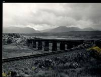
32483AB1974. Scotland 1974-2002. Oblong-Folio 44 cm wide x 36 cm high. Hardcover / Original Full-Leather Folders with stong black cardboards and original tissue-guards. Excellent condition with only minor signs of wear. With hundreds of manuscript annotations on the photography the photography-technique film used and with extensive elaborations on each photograph in these albums. More images on request ! Album 1: Covers the years 1974 1977 and 1978. The West Highland Line is walked from Arrochar a 1977 driving and camping holiday and a 1978 seventeen day touring holiday with many nights sleeping in a car fill the leaves with c. 200 b/w original photographs. Album 2: Covers the years 1991 and 1992. It is noted that 1990 is the fourth year that returning locomotives from the Mallaig line will work south over the West Highland main line. Images of Corrour Summit Glasgow to Fort William trains and many many more bridges viaducts tunnels stations and signalling equipment fill the leaves. c.182 b/w original photographs. Album 3: Covers 1993. More colour photographs now fill the leaves and annotations cease to second half of album. c 270 b/w colour and tinted original photographs. Album 4: Covers 1999 and 2002. Many images from The Highlands Rail Festival in Sept 1999. c.250 b/w and colour original photographs. An extraordinary photographic record and passion project presented in 4 huge well-bound albums containing over 900 fine photographs taken curated and annotated by an unidentified railway enthusiast and talented photographer. The albums span 4 decades recording trips to some of the most scenic and famous rail locations in the UK. The West Highland Line is returned to again and again over the decades and our photographer captures Scotlands most dramatic landscapes and railways as the route passes on its way from Glasgow to Mallaig through sections including Corrour and Rannoch Moor. Albums and contents in fine condition. A tissue guard between every leaf protects the photographs within. A single photograph of a middle aged man among every other photograph which records a detail of the railway is the only clue to the albums previous ownership and perhaps authorship. Partial description by our colleague Dr.Christian White from Christian White Rare Books in Ilkley UK. __________________________________________________________________________________________________________ The West Highland Line Scottish Gaelic: Rathad Iarainn nan Eilean "Iron Road to the Isles" is a railway line linking the ports of Mallaig and Oban in the Scottish Highlands to Glasgow in Central Scotland. The line was voted the top rail journey in the world by readers of independent travel magazine Wanderlust in 2009 ahead of the notable Trans-Siberian line in Russia and the Cuzco to Machu Picchu line in Peru. The ScotRail website has since reported that the line has been voted the most scenic railway line in the world for the second year running. The West Highland Line is one of two railway lines that access the remote and mountainous west coast of Scotland the other being the Kyle of Lochalsh Line which connects Inverness with Kyle of Lochalsh. The line is the westernmost railway line in Great Britain. At least in part the West Highland Line is the same railway line as that referred to as the West Highland Railway. History: The route was built in several sections: Glasgow Queen Street to Cowlairs Junction - Edinburgh and Glasgow Railway Cowlairs Junction to Bowling - Glasgow Dumbarton and Helensburgh Railway later absorbed into the Edinburgh and Glasgow Railway Bowling to Dumbarton Central - Lanarkshire and Dumbartonshire Railway operated by the Caledonian Railway Dumbarton Central to Dalreoch - Caledonian and Dumbartonshire Junction Railway Dalreoch to Craigendoran - Glasgow Dumbarton and Helensburgh Railway Craigendoran to Fort William opened 11 August 1894 - West Highland Railway sponsored by the North British Railway Crianlarich to Oban - Callander and Oban Railway operated by the Caledonian Railway. There is an additional section from Fort William or a junction near Fort William to Mallaig built as the Mallaig Extension Railway. The West Highland Railway approved the construction of the line at their annual meeting in January 1895. The line faced potential closure as part of the Beeching cuts in 1963 and again in 1995 due to reduced revenues. Route description: Shortly after leaving Glasgow Queen Street station and beyond Queen Street Tunnel the line diverges from the main trunk route to Edinburgh Waverley and Perth at Cowlairs and follows a northwesterly course through the suburbs of Maryhill and Kelvindale. Between Westerton and Dumbarton the route is shared with the North Clyde Line to Helensburgh Central before branching northward at Craigendoran Junction towards Garelochhead the section where the West Highland Line itself is generally accepted to begin. It gives high-level views of the Gare Loch and Loch Long before emerging alongside the northwesterly shores of Loch Lomond then climbs Glen Falloch to Crianlarich. The branch to Oban diverges at Crianlarich an important Highland junction of both road and rail and runs through Glen Lochy to Dalmally and through the Pass of Brander to reach salt water at Taynuilt and Connel Ferry before a final climb over a hill to Oban. About three miles five kilometres from Crianlarich the Mallaig and Oban routes both pass through the village of Tyndrum but they are served by separate stations making it an unusually small settlement to be served by more than one railway station. After Bridge of Orchy the line to Mallaig climbs onto Rannoch Moor past the former crossing point at Gorton Crossing to Rannoch station. In winter the moor is often covered with snow and deer may be seen running from the approaching train. The station at Corrour on the moor is one of the most remote stations in Britain and is not accessible by any public road. This is the summit of the line at 1347 ft 410 m above sea level. Carrying on northwards the line descends above the shores of Loch Treig and through the narrow Monessie Gorge. The final stop before Fort William is Spean Bridge. The section between Fort William and Mallaig passes over the Glenfinnan Viaduct through Arisaig with its views of the Small Isles of Rùm Eigg Muck and Canna and the white sands of Morar before coming to Mallaig itself. With the exception of the route between Glasgow Queen Street and Helensburgh Upper and the short section between Fort William Junction and Fort William station the railway is signalled using the Radio Electronic Token Block controlled from the signal box at Banavie station. Notable railway-related features Glenfinnan Viaduct The Horse Shoe Curve between Upper Tyndrum and Bridge of Orchy The Cruach Rock snowshed between Rannoch and Corrour Glenfinnan Viaduct between Locheilside and Glenfinnan The Pass of Brander stone signals between Dalmally and Taynuilt Arisaig is the most westerly railway station in Great Britain West Highland Line in film: Train crossing bridge at Banavie The summit of the line just north of Corrour Glenfinnan Viaduct on the line between Fort William and Mallaig is a filming location for the Hogwarts Express in the Harry Potter series of films. Eddie McConnell's poetic documentary A Line for All Seasons 1970 showcases the line and its history set against the scenery of the western highlands as it changes through the seasons. Corrour features in Trainspotting 1996 directed by Danny Boyle. Source: Wikipedia hardcover
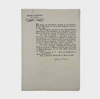
1835377678Mexico 1835. 1. plus integral blank. Signed in print by Estrada. Folio. Unbound. 1. plus integral blank. Signed in print by Estrada. Folio. A broadside decree issued by Migual Barragan giving city status to Pueblo de Nuestra Se ora la Reina de Los Angeles and naming it the provisional capital rather than Monterey. The Mexican congress declares: "The town of Los Angeles of Alta California is elevated to the rank of city and it will be from now on the capital of this territory." However representatives from Monterey would block moving the capital. <br /> <br /> "This decree was largely due to the efforts of Carlos Antonio Carrillo the deputy from California to the Mexican Congress and the author of the Exposicion of 1831" Streeter. Streeter's copy sold for $200 to Dawson's in 1968. Eberstadt 133-187; Streeter sale 2476; Rocq 4223 unknown
1838021038London: T. McLean D.& P. Colnaghi and John F. Lewis 1838. 1838. Book. Illus. by John F. Lewis. Near Fine. Hardcover. First Edition. Folio approx. 55 x 36.5cm. Complete with all Lithographic plates as called for; tinted frontispiece tinted title-vignette further 27 tinted views on 25 leaves all by Lewis after Coke Smyth. A very clean bright copy. Finely bound in modern brown morocco to style with gilt lettering to the spine and gilt bands to the top and bottom of the spine. Contents clean and tight new light brown endpapers in keeping with the new binding two blank leaves to the front and rear all pages have been professionally cleaned and restored by a paper conservator minimal and unobtrusive water staining remains to some pages and plates mostly confined to the margins and blank areas most plates unaffected new archival paper guards to all plates no inscriptions. A fine complete copy beautifully rebound. References -. Abbey Travel II 394; Atabey 722; Blackmer 1015; Contominas 413; RIBA 1886. T. McLean, D.& P. Colnaghi and John F. Lewis [1838]. Hardcover
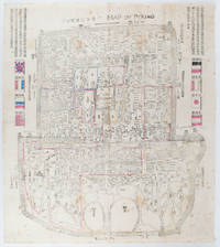
1900169765Circa1900. Large illustrated map of Beijing showing the city in the period following the invasion of the military forces of the Eight National Alliance old folds scale not given. Some scattered light foxing particularly at edges short closed tear at fold lower edge neat non acidic tape repair short section upper edge wear along folds and a couple of small unobtrusive holes with minor image loss. Blocks of text in traditional Chinese right and left upper sections stating each nation's occupied zone Japanese text title accompanies the English title along the upper section of the map. 63.7 x 56.9cm. Very good overall. A rare and significant large Japanese woodblock map of Peking Beijing issued just after the suppression of the Boxer Rebellion. Centred on the Forbidden City the map depicts Peking following the multinational suppression of the Boxer Rebellion or Yihetuan Movement of 1900. The map was issued to illustrate the areas of occupation associated with each of the powers in the Eight Nation Alliance. <br> <br>The map gives measurements of the city walls detailed names of streets and buildings and the boundaries of the inner and outer city including the forbidden city are shown with demarcation lines in pink yellow and blue. The hand coloured eight national flags of the occupation powers are featured at the right and left. <br> <br>This map is essentially a later edition of 京城内外首善全圖 a map of Beijing issued by the Qing for administrative purposes in the mid-19th century. The Japanese seized the wood blocks during the suppression of the Rebellion and subsequently pulled new impressions overprinting them additional details including flags and demarcations of areas of the city held by members of the Alliance. Versions are known in French German Japanese and as with the present example English. An attractive map of great historical interest. . unknown
17992111902160200187Washimi Tamotsu 1799. Soft Cover. Fine. Number of books: 1 book Washimi Tamotsu paperback
5234Barcelona: Viladot Facsimils. Viladot Facsimils unknown
199524401995 Lucerne, Editions Facsimilé, 1995. 30,5x44 cm. Fac-similé reproduisant à l'identique la première partie du manuscrit enluminé conservé sous la cote ms. fr. 2810 à la Bibliothèque Nationale de France à Paris. Format des feuillets légèrement variable comme sur l'original médiéval. Texte en français médiéval. Superbe reliure en plein veau marron. Plats ornés des armoiries royales françaises. Dos à 8 nerfs, orné de caissons dorés portant le monogramme L (Louis, roi de France). Pièce de titre en maroquin rouge. Roulettes dorées à l'intérieur des plats. Coffret recouvert de soie bleu-roi et orné des armoiries royales sur le plat supérieur. Minimes et très discrètes traces de frottement sur la reliure, sinon ouvrage en excellent état et d'une qualité exceptionnelle.
18572234Genève, Impr. de Gme Fick, 1857. In-folio broché de IX-69 pages, 29 planches. Coupes légèrement déchirées sur les plats, deux petits manques au bas et haut du dos, quelques rousseurs.
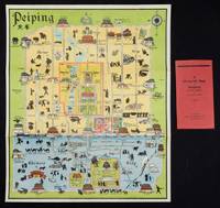
1934158433Peiping.: Peiyang Press. circa1934. Coloured folding plan of Peking with original envelope. 60 x 50cm. A few neat repairs at folds two panels evenly browned on reverse. A very good copy of a scarce pictorial plan with its envelope. This delightful and scarce pictorial map of Peking with landmarks and streets in romanised Chinese with occasional Chinese characters is surprisingly scarce. Although apparently issued in several editions in the 1920s and 30s it appears relatively infrequently on the market. The divisions of the Legation District are indicated by their flags - this edition shows the German Legation by use of the black white and red bands of the German flag. This flag which was no longer used after 1935 helps date this edition. Other landmarks and attractions shown included theatres foreign shopping area adjacent to the legations quarter Liu Li Chang Curio District the racecourse the many city gates etc. . Peiyang Press. unknown
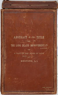
188525162Riverhead New York 1885. Hardcover. Very good condition. The original manuscript title to a very large tract of land near Brookhaven Long Island acquired by John A. Bowman from the individual proprietors and conveyed here by Bowman in its entirety to the Long Island Improvement Company Ltd. <br /> <br /> The Long Island Improvement Company was formed by Austin Corbin then president of the L. I. Rail Road and others in 1881. Corbin sought the land in order to develop expensive summer residences on Long Island; Bowman was acting as Corbin's agent in the acquisition of this valuable property. Austin Corbin 1827 – 1896 was an American railroad executive plantation owner resort operator banker and robber baron. In Iowa as a bank president he engaged in mortgage scams. Later through theft and corruption he consolidated the individual rail lines into the profitable Long Island Rail Road. He was widely despised in his day: Puck Sept 1882 printed a caricature in which Corbin appears at a Louis XIV styled party where he carouses with Jay Gould and other robber barons. <br /> <br /> The Abstract a bound sml. folio volume records that Bowman paid $5 per acre for most of the parcels in 1882 then conveyed January of 1883 the incalculably valuable entire tract to the LI Improvement Co for $1. The Abstract volume concludes with the Suffolk County embossed seal and is signed by the Clerk at Riverhead 1st June 1885. It includes the ownership history of each parcel as well as a history of the town of Brookhaven from its founding.<br /> <br /> The Abstract volume is accompanied by the original hand colored manuscript map on architectural vellum of the entire tract with silk ribbon binding showing the 25 property owner names and parcel sizes. Surveys were conducted by Justus Roe. The map is titled "Map of Property of the Long Island Improvement Company Limited at Medford LI". The scale is 300 feet to the inch. The northern boundary of the tract shows the Brewster Terry Property and Horse Block Road; the western edge defined by Tunnel and Progues Road and the Austin Roe and Daniel Gerard property; the southern boundary with Georgianna Rider property and Canaan and Medford Roads; the eastern boundary with the Robinson property and Lime Road. The Long Island RR can be seen running from east to west at approximately one third of the way through the tract at the north side. The map signed in ink at the lower right corner E. H. H. Forder.<br /> <br /> The Abstract bound in full gilt tan leather 9 x 14 3/4" attorney's name stamped in gilt at lower corner James Armstrong Attny 115 B'Way N. Y. Boards slightly rubbed; front board detached but present. Pages very bright and clean. The map 67 x 44" a few short splits at folds but very bright and clean in very good condition.<br /> <br /> A remarkable record of Long Island land speculation in the late 1880s. hardcover
409884Wear and staining to leather but covers sound. Internally in fine condition. Folio ledger book 16 3/4 x 11 inches; 425 x 278 mm. Manuscript on paper: 2 570 pages. 226 very finely drawn plot maps with wash ranging from small insertions on pages to full-page illustrations. Bound in original ledger leather gilt with label of Ackerman Co Providence gilt-lettered with title on spine. A superb record of the land deeds related to the development of the Providence & Worcester Rail Road Company P & WRRC. The preliminary pages record the sale of a section of land to the Lonsdale Company on 31 July 1871 the preliminaries are dated 1899. The Lonsdale Co. Mill Railroad was a short branch from the main line of the P & WRRC to the Lonsdale Mills Lonsdale is a village and historic district in Lincoln and Cumberland Providence County. What follows are the deeds with plot maps and names of their owners from 17 October 1846 to 21 November 1883. A note on a front flyleaf reads: "See Certificate signed by Charles Hatch on the fly leaf of Volume 1 of this series of Deed Books. November 1899. James W. Perkins." Perkins has added another note in pencil on the verso of the front free endpaper: "Plan Book No. 2 referred to in Index od Deeds of P and WRR Co. JWP."<br /> <br /> The company was founded in 1844 to build a railroad between Providence Rhode Island and Worcester Massachusetts and ran its first trains in 1847 - the year after the earliest deed recorded in this plot book. A successful railroad the P&W subsequently expanded with a branch to East Providence Rhode Island and for a time leased two small Massachusetts railroads. Originally operating on a single track its busy mainline was double-tracked beginning in 1853 following a fatal collision that year in Valley Falls Rhode Island. The P&W operated independently until 1888 when the New York Providence and Boston Railroad NYP&B leased it. unknown
1788024356London: Printed for J. Walker 1788. Book. Very Good. Hardcover. First Edition. 12mo. A very good four volume set in contemporary full tree calf binding with double lettering pieces in red and green. Complete pp. iii-vii 1 222; 2 206; 2 238 & 2 198. No half-titles which may or may not be wanting but the pagination for the prelims to vol. I might suggest that one is required Very good bindings with a little rubbing a couple of volumes slightly chipped to the head/tail of the spines corners lightly bruised. Contents clean and tight manuscript Greek initials to title pages dated 1788 otherwise unmarked no foxing paper crisp. A very good set. A Rare Eighteenth Century Novel. We have managed to located just one other copy at auction in the last thirty years and that at Sotheby's sale of July 21 1993 where it made £1000 on the hammer though seemingly not such a nice copy. Referenced by: ESTC T068744. Printed for J. Walker Hardcover
1953013812New York Ace Books, Inc. - Collection « Ace double books » D-15 1953 In-12 broché, couverture illutrée Signé par l'auteur
18822111902160200908Ikaho bussan 1882. Soft Cover. Fine. Volume: 1 Ikaho bussan paperback
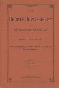
188647038Lincoln: Journal Company State Printers 1886. 1886. NEBRASKA RAILROAD. First edition. 8vo. Original orange printed wrappers 16 pp. folding map: Map of Nebraska 1886. 59 x 99 cm. 23 1/4" x 41" 12 miles to one inch. The map was the project of the Burlington Route for selling land. Very detailed and routes outlined in bright red. Broken Bow was to be the new center of life in Nebraska. The map is in fine condition some splitting at the bottom two inches of the spine due to the folded size of the map and a tiny closed tear and a few minor nicks to the rear cover fore-edge overall a near fine copy. Journal Company, State Printers, 1886. unknown
174019595(Augsburg), Matthäus Seutter, um 1740. Ca. 50 cm x 58 cm (Platte).
2016120005Promopress. New. 2016. Hardcover. 8416504083 . FREE UPGRADE to Courier/Priority Shipping Upon Request - IN STOCK AND IMMEDIATELY AVAILABLE FOR SHIPMENT - Flawless copy brand new pristine never opened. Text in English French Spanish and Italian. -- with a bonus offer-- . Promopress hardcover
201188890Verlag Fur Moderne Kunst. New. 2011. Hardcover. 3869841362 . FREE UPGRADE to Courier/Priority Shipping Upon Request - IN STOCK AND IMMEDIATELY AVAILABLE FOR SHIPMENT - Flawless copy brand new pristine never opened -- Text in German and English. 96 pp; 41 color illustrations. -- with a bonus offer-- . Verlag Fur Moderne Kunst hardcover
1418159850Shūseidō 衆星堂. Reprint. Tenpō 14 1843. Large folding handcoloured map of the thirteen provinces from which Mt. Fuji can be viewed. 159 x 178cm. Folds into paper covered card covers measuring 40 x 24cm. Title label upper cover. A little browning along folds occasional spotting and soiling. A little worming causing approximately 1cm of loss in places. Two chops in lower section. A very striking and attractive map. This very large handsome map is a detailed map of the thirteen provinces from which one can see Mt. Fuji. Provinces shown are the eight provinces of the Kantō region Sagami 相模 Musashi 武蔵 Kazusa 上総 Shimofusa 下総 Awa 安房 Kōzuke 上野 Shimotsuke 下野 and Hitachi 常陸 and five other provinces Izu 伊豆 Suruga 駿河 Tōtōmi 遠江 Kai 甲斐 and Shinano 信濃. The map offers a large amount of detailed information such as province and county borders rivers high ways post towns checkpoints villages and scenic spots. <br> <br>The cartographer Akiyama Einen or Nagatoshi 秋山永年 came from Edo and the editor Funakoshi Seizō 船越清蔵 studio name: Shugu 守愚 1805-62 a Confucian scholar from Nagato Province now the western half of present-day Yamaguchi Prefecture. A dedication by Funahashi Akira 舟橋徴 is dated 1843. . Shūseidō 衆星堂 unknown
191353568Hornell NY & Low Moor VA: Homer A. Sitterley Asst. City Engineer for Hornell NY; Chief Mining Engineer Low Moor Iron Co. 1913-1917. Oblong 8vo. 10 x 7 in. 142 pp unpaginated. thick black paper stock w/ 298 original photographs sized from 2 x 3 in. up to 3.25 x 5.5 inches 280 this size 2 of them cyanotype and the majority with neat white ink manuscript descriptions linen-backed frontisp. map of Hornell NY dated 1915. Contemporary limp black-cloth post-binder sewn at gutter margin w/ black silk braid minor soiling tidemark to outer fore-edges of front cover first couple leaves minor fraying & wear to corners still a VG- exemplar w/ most images with strong contrast. This remarkable album documents the tremendous range of road building projects sewer improvements bridge building and dam construction in and around Hornell NY in Steuben County in the years before World War I. Steuben County was the next to the last County in New York State to join the Good Roads Board sponsored by the American Automobile Association in 1907 primarily because during the opening decades of the 20th century that area of New York had some of the worst roads. These images show the construction and building of sewer lines on Crosby Street Canister Street paving projects on East Ave. Jane Street West Street -- with fantastic images of early Foote Concrete Machinery Co. road paver in operation pouring concrete West Genesee Street Church Street and others. Sitterley b. 1889 makes a study of the filtering systems and sewer plant for New York City at the time includes photo of the newly opened Hornell trolley “Subway†as well as numerous photos of poor condition sidewalks which were slated for modernization as an adjunct of the Good Roads agenda hand-in-hand with laying of new sewer lines. In addition he has included photo of himself with surveyor’s transom and the Hornell City Engineer together with the City Park Superintendent. A significant portion of the album is devoted to the building of the Seneca Street Bridge including the building of the coffer dams to hold back the water to pour the piers the construction of the abutments and finally the finished bridge. That bridge would later be rebuilt by a WPA project in 1936 and now is up for replacement again. Sitterley’s last major projects were overseeing the building of the new Hornell city dams and city reservoirs together with road improvements gate houses and spillways. In March 1916 he leaves Hornell NY to become Chief Mining Engineer for the Low Moor Iron Co. which was a producer of pig iron in Alleghany County of Western Virginia which operated from 1872-1930. The company was often plagued with labor unrest as they maintained very poor “Company†towns and were constantly struggling with the Chesapeake & Ohio Railroad to ship their ore. In 1916 they were on the upswing as a company as the growing steel demands of World War I began to lift all ore producers at the time. See: Corning Convention of Good Roads Associations Good Roads Magazine April 1907 pp. 134-135; Homer Aldrich Sitterley Bi-Monthly Bulletin of the American Institute of Mining Engineers No. 126 June 1917 p. xxxv; Russell Story of the Great Flood and Cyclone Disasters in New York State 1913 New York Roots 1999; Papers of the Low Moor Iron Company 1873-1927 Special Collections Univ. of Virginia Library 2010. Homer A. Sitterley, Asst. City Engineer for Hornell, NY; Chief Mining Engineer, Low Moor Iron Co., hardcover
S52Ensemble d'environ 600 cartes.
183523580MÉXICO: Impreso por Ignacio Cumplido 1835. Primera edición.- 4º.- Plena piel jaspeada de época lomera con filetes y florones dorados.- 2 tomos en 1 volumen.- I: 32 páginas.- II: 56 páginas.- III: 44 páginas. El Apéndice de documentos no indica lugar ni año. El primer documento lleva la fecha de México 24 de febrero de 1835 y el último es de 23 de mayo del mismo año. Procedencia: Ejemplar de Joaquín Gómez de la Cortina Marqués de Morante. Palau 111572 para la segunda edición y 74785 Impreso por Ignacio Cumplido unknown
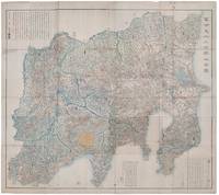
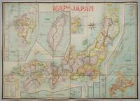
1906197908Kobe Japan.: Fuku-In-Kwan. 1906. Printed colour folding map on two conjoined sheets laid down 73.8 x 10⁵ cms foxing on verso not affecting map single pinhole in each corner scant spotting small fold splits no loss a few soft fold creases but in good condition. Very rare striking map of Japan published for the Western market. <br> <br>Created under the direction of Takachika Okishio featuring 10 inset maps: Chishima Kurile Islands Hokushu Hokkaido Ogasawara-Jima Bonin Islands Hachijo-Shima Ioshima Okinawa Saki-Shima Kyushu Saikaido Taiwan Formosa and Eastern Asia. The insets of Taiwan and Kyushu are the largest and centrally positioned. A Glossary and Explanation of Signs is printed at the foot of the map which list Towns Railway Stations Boundaries of Prefectures Notable Places Hot Springs Water-falls rapids Volcanoes Light-Houses Gold Silver and Coal-Oil fields. The Japanese Government Railway series of Travellers' Maps of Japan appear to have been modelled after this design. . Fuku-In-Kwan. unknown
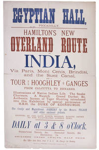
99252London Printed by S. Golbourn February 1876. . Broadsheet 51.25 x 31.4 cm printed in blue and tan horizontal centre fold short split short splits to head a good example.<br /> Rare broadsheet advertising an exhibition at the Egyptian Hall. The Egyptian Hall was a leading venue for exhibitions featuring original artwork and relics.<br /> London, Printed by S. Golbourn, February 1876. unknown
Very Good Turkish, Ottoman (1500-1928) A modern fine black leather bdg. Small 4to. (26 x 18 cm). In Ottoman script. 3 volumes set: ([13], 448, [11], [6] p.; 386, [12], [6] p.; 203 p). Ibn Battuta was the greatest medieval Muslim traveler and the author of one of the most famous travel books, the Ri?lah (Travels). His great work describes his extensive travels covering some 75,000 miles (120,000 km) in trips to almost all of the Muslim countries and as far as China and Sumatra (now part of Indonesia). Ibn Battuta was from a family that produced a number of Muslim judges (qadis). He received the traditional juristic and literary education in his native town of Tangier. In 1325, at the age of 21, he started his travels by undertaking the pilgrimage (hajj) to Mecca. At first his purpose was to fulfill that religious duty and to broaden his education by studying under famous scholars in Egypt, Syria, and the Hejaz (western Arabia). That he achieved his objectives is corroborated by long enumerations of scholars and Sufi (Islamic mystic) saints whom he met and also by a list of diplomas conferred on him (mainly in Damascus). Those studies qualified him for judicial office, whereas the claim of being a former pupil of the then-outstanding authorities in traditional Islamic sciences greatly enhanced his chances and made him thereafter a respected guest at many courts. That renown was to follow later, however. In Egypt, where he arrived by the land route via Tunis and Tripoli, an irresistible passion for travel was born in his soul, and he decided to visit as many parts of the world as possible, setting as a rule "never to travel any road a second time." His contemporaries traveled for practical reasons (such as trade, pilgrimage, and education), but Ibn Battuta did it for its own sake, for the joy of learning about new countries and new peoples. He made a living of it, benefitting at the beginning from his scholarly status and later from his increasing fame as a traveler. He enjoyed the generosity and benevolence of numerous sultans, rulers, governors, and high dignitaries in the countries he visited, thus securing an income that enabled him to continue his wanderings. From Cairo, Ibn Battuta set out via Upper Egypt to the Red Sea but then returned and visited Syria, there joining a caravan for Mecca. Having finished the pilgrimage in 1326, he crossed the Arabian Desert to Iraq, southern Iran, Azerbaijan, and Baghdad. There he met the last of the Mongol khans of Iran, Abû Sa'îd (ruled 1316-36), and some lesser rulers. Ibn Battuta spent the years between 1327 and 1330 in Mecca and Medina leading the quiet life of a devotee, but such a long stay did not suit his temperament. Embarking on a boat in Jiddah, he sailed with a retinue of followers down both shores of the Red Sea to Yemen, crossed it by land, and set sail again from Aden. This time he navigated along the eastern African coast, visiting the trading city-states as far as Kilwa (Tanzania). His return journey took him to southern Arabia, Oman, Hormuz, southern Persia, and across the Persian Gulf back to Mecca in 1332. There a new, ambitious plan matured in his mind. Hearing of the sultan of Delhi, Mu?ammad ibn Tughluq (ruled 1325-51), and his fabulous generosity to Muslim scholars, he decided to try his luck at his court. Forced by lack of communications to choose a more indirect route, Ibn Battuta turned northward, again passed Egypt and Syria, and boarded ship for Asia Minor (Anatolia) in Latakia. He crisscrossed that "land of the Turks" in many directions at a time when Anatolia was divided into numerous petty sultanates. Thus, his narrative provides a valuable source for the history of that country between the end of the Seljuq power and the rise of the house of Ottoman. Ibn Battuta was received cordially and generously by all the local rulers and heads of religious... Hejra: 1333; 1335; 1336 = Roumi: 1335 ; 1337; 1340 = Gregorian: 1917; 1919; 1921. Ozege: 21289. For fihrist: 5771.