2 245 résultats
1917214418London and New York.: The Foreign and Colonial Compiling and Publishing Co. 1917. Numerous black and white photographic illustrations. 768pp. Full red morocco binding spine lettered and ruled in gilt in compartments 'Tiger head' emblematical device stamped in gilt on the upper board repeated in gilt on the title page corner ornaments blocked in gilt. All edges gilt marbled endpapers light rubbing to corners but a lavishly produced edition in exceptional condition. 30 x 23.5cm One of a series of publications published with the object of supplying the British public with a picture - complete as far as literary and pictorial effort could make it - of the several different parts of the Empire. in this instance Northern India. . The Foreign and Colonial Compiling and Publishing Co. unknown
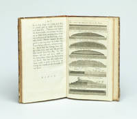
173729354London Gilliver and Clarke 1737. 8vo. Near contemporary half calf with gilt title label. 16622 pp. and 8 engraved plates 1 folding. 4cm tear to bottom of title page - proffesionally repaired with no loss. A fine clean copy. <br/><br/><em>First edition. Phillips recognized that a layer of gravel if resting on a well-drained dry sole would be beaten by the traffic into a firm road surface. He was thus the pioneer in the development of the Macadam method. The present work is described in Gregory: The Story of the Road p.207-211. Very uncommon. </em> unknown
20122081502111907996Shandong University 2012. Soft Cover. Fine. Size: B5 hardcover book Shandong University paperback
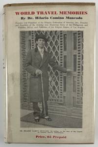
193212800Washington DC: Claude T. Clements Press 1932. 14362pp. Profusely illustrated. Publisher's tan cloth with titles stamped in brown on spine and front board. In original unclipped pictorial dust jacket. Minor edge wear light insect damage to boards. Dust jacket either trimmed a bit short or originally produced a half-inch shorter than boards. Minor dust-soiling to jacket with minor insect damage to rear flap. Internally clean. Overall very good. The rare autobiographical travel narrative by one of the most important Filipino-American political leaders in history especially notable for retaining the original pictorial dust jacket. Hilario Camino Moncado established the Filipino Federation of America in 1925 in Los Angeles California. It was also known at various times as the Filipino World Federation and the Filipino Crusaders World Army. As one of the fraternal organizations appealing to the small but growing Filipino immigrant community the FFA distinguished itself from competitors by accentuating "clean living" and rules of moral conduct. Moncado earned a law degree and also edited and published Filipino Nation. Through his work Moncado sought to portray the immigrant community as responsible and healthy in contrast to the then-prevalent depictions of them as uneducated gamblers. Much less publicly the FFA developed a set of religious teachings that held Moncado to be the reincarnation of Jesus Christ by way of José Rizal the Filipino patriot executed in the waning days of Spanish rule. Moncado's birthday was changed to make him appear to have been born after Rizal's death so that his identity as Rizal's reincarnation would be more plausible.<br /> <br /> In the present travel memoir Moncado focuses on political and social issues encountered on a trip around the world conveying an impression of worldliness which burnished his reputation within the Filipino-American community. He visits England Holland Germany France Italy Egypt India China Japan and "Home Sweet Home Philippines." A sampling of chapters focus on London his visit to Oxford University the refusal of Germany to pay reparations from the First World War mentioning the German people's and particularly Hitler's stance against paying them any further his visit to the League of Nations "Mussolini - Benevolent Despot or Tyrant" Gandhi and "India's Revolution" China "The Awakening Giant" "Americanized Japan" and the betrayal of the Filipino independence movement by the American Congress.<br /> <br /> OCLC records just eight institutional copies including one in the Philippines one in Singapore and six in the United States at NYPL UC-Davis the University of Hawaii Michigan Washington and Wisconsin. Claude T. Clements Press unknown
B306546-1Kamakura-shi Shiruku Rodo Kenkyujo 1990-2004. Vols. 3 - 5 7 - 9. Lrg. 4to. Cloth. With: Festschrift Ikuo Hirayama. Studies in Silk Road Coins and Culture: Papers in Honour of Professor Ikuo Hirayama On His 65th Birthday. Edited by Katsumi Tanabe Joe Cribb Helen Wang. Silk Road Art and Archaeology. Special volume 1997. 332pp. Prof. illus. Lrg. 4to. Cloth. Kamakura The Institute of Silk Road Studies 1997. Kamakura-shi (Shiruku Rodo Kenkyujo), 1990-2004. hardcover
1945208877Chicago.: Chicago Daily Tribune. August1945. Printed colour pictorial map on a single newspaper leaf 37 x 52 cms; 43 x 59.5 cms sheet three inset maps archivally laid down on linen very good condition. Full page map published in the "Chicago Daily Tribune" after the bombing of Hiroshima and Nagasaki prior to occupation by US and Allied forces in September 1945. "This is a new map of the main islands of Japan where American occupational troops will land and establish their military rule." map text The legend notes "Places bombed by U.S. Air Forces with a red circle" and "Cities bombed by Atomic Bomb" with a red star. The main map shows the Japanese islands of Honshu Shikoku and Kyushu with the Korean peninsula. Inset maps show Hokkaido Formosa and a general map of the area. . Chicago Daily Tribune. unknown
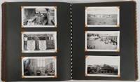
177650154 black and white snapshots held in place with photograph corners in a patterned fabric covered photograph album. Sizes of the photographs vary from 5 x7.5cm to 8.5 x 12.5cm. Black and white folding map of Burma 34.7 x 24cm loosely inserted two insets on the map show an elephant carrying teak a mahout on his back and a small map showing Burma's location within the region. Although the photographs are not individually captioned the album is divided into sections titled in white ink. Some blank leaves towards the rear of the album a separate section of 10 photographs titled "Burma & China" fills the last leaves. Six photographs are evenly browned all others are in excellent condition. A very interesting photograph album in excellent condition. A fascinating photographic record of events on the crucial Burma Road in southwestern China during and immediately after the Pacific War. An inscription on the final leaf gives the name John Barry Williams and the date 6/23/42 to 1/15/46. <br> <br>The Burma Road was constructed in 1936-1937 mainly to enable the allies to send material to China which was then at war with Japan. After the occupation of Burma by Japan in 1942 the flow of goods was cut until 1945 when in the last months of the war allied troops reconnected the transport corridor from Burma to China. Meanwhile war materiel continued to be transported by plane between Yunnan in China and India over the section of eastern Himalayas known as 'The Hump'. <br> <br>The owner of this album appears to have been a US serviceman stationed at Tsuyung Airfield in the Chinese province of Yunnan - the main transport hub at the Chinese end of the Hump route. The first photos in the album show scenes of the Burma Road and the Salween River on the border of Yunnan and Burma. There are a number of fine black-and-white photos of everyday life in the area including a village street a local salt mine a farmer ploughing with water buffaloes a street scene in Tsyuyung town women and children repairing the road and a train of pack ponies taking goods to market along the Burma Road in China. There are also images of a serviceman named Washburn holding up a captured Japanese flag. <br> <br>The following series of photos is labelled '780 Engineer Petroleum Distribution Co. Pipeline India-Burma-China 1944 and 1945' and shows scenes of the contruction of this vital fuel link with photos shot in India in the jungles of Burma and in southwestern China. The photos give a vivid image of the magnitude of the construction task showing teams camping out in rugged terrain and crossing rivers on makeshift bridges. A final group of photos labelled 'Burma and China' includes shots of a parachute drop from a plane and an image of allied soldiers with local villagers. A small map of Burma and Tibet published in 1948 has been loosely inserted in the front of the volume. . unknown
10-21385Ediciones Libertarias. Paperback. New. In shrink wrap. Ediciones Libertarias paperback
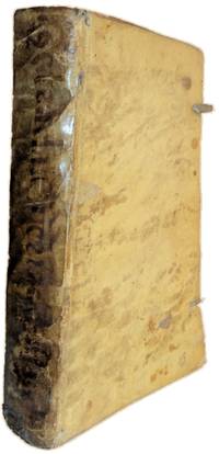
1306JC097<p>Desde el principio del Govierno de ALEXANDRO FARNESE Tercero Duque de Parma y Placencía. Escrita en Latin Por el P. Famiano Estrada de la Compañia de Jesus. Y traducida en Romance Por el P. MELCHOR de NOVAR de la misma Compañia. Corregida y enmendada Por el Doctor de BONNE-MAISON. EN COLONIA Con los Privilegios de necessarios. Año M D C L X X X I I 1682.</p>_x000d_<p>In 4.º de 29x185 cm. Com iv 576 i.e. 578 págs. Encadernação da época em pergaminho flexível com título manuscrito a pena ao longo da lombada e vestígios dos atilhos.</p>_x000d_<p>Rosto impresso a preto a vermelho com o trigrama sagrado geralmente usado pela Companhia de Jesus à cabeça e florão ornamental. Obra ornada de florões de remate no final dos capítulos e iniciais decoradas ao início. Inclui notas marginais com cronologia.</p>_x000d_<p>Exemplar com falhas de material na pasta posterior que está descolada do miolo e no pé da lombada; pequenas falhas nas folhas de guarda estando a posterior descolada da respectiva pasta e contendo diversas anotações e assinaturas de posse a pena na guarda posterior. Apresenta manchas de humidade no canto inferior das folhas junto ao corte mais proeminentes a partir da página 303. A partir da 483 tem também pequenos rasgos e falhas de papel que atingem as notas da 556 em diante. Pequenos picos de traça na margem inferior das páginas 403 a 428 que atingem levemente as últimas linhas e as assinaturas das folhas sem condicionar a leitura. O corte das folhas muito justo afeta a mancha tipográfica do cabeçalho das páginas 173/174.</p>_x000d_<p>Apresenta os seguintes erros de paginação: as págs. 197-198 constam em duplicado; gralha na paginação da 439 constando ao invés 389.</p>_x000d_<p>Primeiras páginas não numeradas com prefácio do autor.</p>_x000d_<p>Este é o segundo volume da obra constituída por três. Cada um aborda uma década dos primeiros trinta anos da Guerra do Oitenta Anos c. 1568-1648 conhecida em Espanha como <em>Guerra de Flandes</em>. O presente volume debruça-se essencialmente sobre o período desde o início do governo de Alessandro Farnese Duque de Parma Roma 1545 Arras 1592 em 1578 até ao final da década de 80.</p>_x000d_<p>Estes anos constituíram uma fase do conflito marcada inicialmente pelas Uniões de Atrecht e Utrecht. Esta última resultaria na criação da República das Sete Províncias Unidas dos Países Baixos que durante esta época foi fortemente atacada e reconquistada pela bem sucedida ofensiva militar e diplomática levada a cabo por Alessandro Farnese. Com o aproximar do fim dos anos 80 as suas reconquistas perdem força e chegam a um término quando Filipe II ordena que ele intervenha nas Guerras Religiosas Francesas setembro de 1589 para evitar a Sucessão de Henrique IV e que a França se tornasse um reino protestante.</p>_x000d_<p>Os dois primeiros volumes da obra foram publicados pela primeira vez em Roma em 1632 e 1647 sob os títulos <em>De bello Belgico decas prima</em> e <em>De bello Belgico decas segunda</em>. O terceiro volume foi continuado por Guglielmo Dondini publicado também em Roma 1673 sob o título <em>Historia de rebus in Gallia gestis ab Alexandro Farnesio Parmae et Placentiae duce III.</em></p>_x000d_<p>Famiano Strada 1572 - 6 de setembro de 1649 foi um jesuíta italiano e historiador das guerras nos países baixos Bélgica e Países Baixos durante a primeira parte da Guerra dos Oitenta Anos desde a abdicação de Carlos V em 1556 até à tomada de Rheinsberg em 30 de janeiro de 1590. Foi admitido na Companhia de Jesus e ocupou a cadeira de Retórica no Colégio Romano. A obra de Famiano foi criticada pelo Cardeal Guido Bentivoglio d"Aragona que escreveu uma história sobre os mesmos acontecimentos e foi criticada por Scioppius que escreveu um panfleto intitulado <em>Infamia Famiano</em> em 1623.</p>_x000d_<p>EN In quarto. 29x18.5 cm. iv 576 i.e. 578 pp. Contemporary binding in flexible parchment with handwritten title in the spine.</p>_x000d_<p>Title page printed in black and red with the sacred trigram generally used by the Society of Jesus at the head and ornamental <em>fleuron</em>. The work is decorated with finishing <em>fleurons</em> at the end of the chapters and decorated initials at the beginning. Marginal notes with chronology.</p>_x000d_<p>Copy with flaws in the rear folder parchment which is detached from the core and at the foot of the spine; signs of tying laces; small flaws in the endpapers the posterior one being detached and containing several annotations and handwritten ownership titles in pen on the rear endpaper. Moisture stains in the lower corner of the leaves near the edges more prominent from page 303. From 483 onwards there are also small tears and paper flaws that reach the notes from 556 onwards. Small moth holes in the lower margin of pages 403 to 428 that slightly affect the last lines and signatures of the leaves without conditioning the reading. The very tight edges affects the text area of the header of pages 173/174.</p>_x000d_<p>Presents the following typographical errors: pages 197-198 are in duplicate; typo in the pagination of 439 instead of 389.</p>_x000d_<p>First unnumbered pages with a foreword by the author.</p>_x000d_<p>This is the second volume of the work which consists of three. Each deals with a decade from the first thirty years of the Eighty Years" War c. 1568-1648 known in Spain as the <em>Guerra de Flandes</em>. The present volume focuses on the period from the beginning of the rule of Alessandro Farnese Duke of Parma Rome 1545 - Arras 1592 in 1578 until the end of the 80s.</p>_x000d_<p>These years constituted a phase of the conflict marked initially by the Unions of Atrecht and Utrecht. The latter would result in the creation of the Republic of the Seven United Provinces of the Netherlands which during this time was heavily attacked and reconquered by the successful military and diplomatic offensive carried out by Alessandro Farnese. As the late 1580s approached his reconquests lost momentum and came to an end when Philip II ordered him to intervene in the French Wars of Religion September 1589 to prevent the Succession of Henry IV and France from becoming a Protestant kingdom.</p>_x000d_<p>The first two volumes of the work were first published in Rome in 1632 and 1647 under the titles <em>De bello Belgico decas prima</em> and <em>De bello Belgico decas segunda</em>. The third volume was continued by Guglielmo Dondini also published in Rome 1673 under the title <em>Historia de rebus in Gallia gestis ab Alexandro Farnesio Parmae et Placentiae duce III.</em></p>_x000d_<p>Famiano Strada 1572 - 6 September 1649 was an Italian Jesuit and historian of the wars in the Low Countries Belgium and the Netherlands during the first part of the Eighty Years" War from the abdication of Charles V in 1556 to the taking of Rheinsberg on 30 January 1590. He was admitted to the Society of Jesus and held the chair of Rhetoric at the Roman College. Famiano"s work was criticised by Cardinal Guido Bentivoglio d"Aragona who wrote a history of the same events and was criticised by Scioppius who wrote a pamphlet entitled <em>Infamia Famiano</em> in 1623.</p>_x000d_<p>Referências/References:</p>_x000d_<p>Iberian Books C84256.</p>_x000d_<p>Palau III 163.</p> M-6-D-1 hardcover
1844GD012817okBC1S5Manchester: Wetmore & Wallace 1844. Manchester: Wetmore & Wallace Rare Americana 1844 First Printing. 8vo. 16 pages with folding map at rear of wrappers. The folding map titled :Plan and Profile of the Route Surveyed for the Northern Railroad from Concord to Lebanon N.H." measuring approxinately 28" long and 9" wide. The map is in extremely nice condition. The spine shows some wear but remains a very nice copy. A signature of S.Chase" appears on the front wrapper. There is an institional rubber stamp on the margin of page 3. Vermont Historical Society Montpelier Vermont. This report printed by Wetmore & Wallace Printers in Manchester New Hampshire presents the findings of an engineer's survey for the Northern Railroad route. It covers the planned railroad connections between Concord Franklin and complete with Lebanon along the Connecticut River. Published in 1844 this document provides historical insight into the development of New Hampshire early railroad infrastructure and the engineering challenges faced in the region at that time. Scarce copy last auction records 1930. First Printing. Paperback. Good/No Jacket. 8vo - over 7¾" - 9¾" tall. Manchester: Wetmore & Wallace
1823ST20595London: Longman Hurst Rees Orme and Brown 1823. Seventh Edition. 237 x 145. 9 3/8 x 5 3/4". 3 p.l. vii 1 viii 1 6-236 pp. <br/> Publisher's blue paper boards and brown paper backstrip original printed paper label EDGES UNTRIMMED AND MOSTLY UNOPENED. A Large Paper Copy. Just the faintest evidence of foxing at very beginning and very end corners with slight wear as always superficial chafing to covers but AN EXCEPTIONALLY FINE COPY the binding remarkably clean and with no significant signs of use and the wide-margined text unusually fresh and nearly as white as snow.<br/> <br/> In its original boards untrimmed and partly unopened this is a wonderful contemporary copy of an important later edition of the magnum opus of a man whose name came to be synonymous with road improvement. DNB tells us that Scottish-born John Loudon McAdam 1756-1836 was "the first systematic builder and administrator of roads in Britain since Roman times" and his impact was so great that his name lives on to the present day in connection with paved surfaces. The use of "macadam" or "macadamized" to mean a good road surface began in the 1820s and continued through the invention of the automobile when dusty roads began to be improved with tar. At first "tar" was combined with "macadam" producing the term "tarmacadam" when referring to these improved roads; eventually this became shortened to "tarmac" which still is broadly understood to refer to road surfaces and more specifically to airport runways. Our author first published "Remarks on the Present System of Road Making" in 1816 to deliver his suggestions for an improved paving method following his extensive survey of the roads of Britain. His system--in which roads were built with a cambered surface for drainage using layers of consistent sizes of stones and gravel--soon caught on both within Britain and abroad. The present seventh edition features a variety of new material much of which deals with McAdam's efforts to encourage legislation for improving roads; this includes a new preface and advertisement as well as the "Minutes of Evidence" given by witnesses regarding turnpike improvement from March to May 1819 and the report of the Select Committee of the House of Commons on McAdam's system from June 1823. As evidenced by its appearance in multiple printings McAdam's "Remarks" was a widely used book but our remarkably well-preserved copy in its publisher's boards--obviously and decidedly--was not. Longman, Hurst, Rees, Orme, and Brown unknown
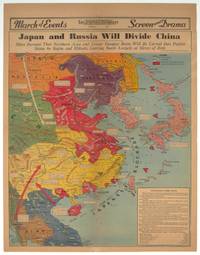
1940209821Los Angeles.: Los Angeles Examiner. 1940. Printed colour pictorial map on a single newspaper leaf 42.3 x 39.9 cms; 54.3 x 42.5 cms sheet archivally laid down on linen slight discoloration to lower centrefold and sheet slightly age-toned but in very good condition. A striking geopolitical map by Los Angeles Examiner artist Howard Burke covering China Japan Southern Russia and the northern part of French Indochina and Siam showing how the "Aggressors Divide China." Areas under Japanese occupation are shown in red and their naval blockade shown by an arc of naval vessels with vivid arrows indicating lines of supply. Text labels including sources of agricultural and raw materials provide a dynamic overview of the geopolitical situation and show the influence of American scientific illustrator and cartographer Richard Edes Harrison who argued for examining geographic issues from multiple perspectives and Los Angeles Times artist Charles Owens. . Los Angeles Examiner. unknown
1806009589London: Printed for Richard Phillips Sold By Souter No. 1 Pater-noster-row. 1806. Book. Very Good. Hardcover. First Edition. Large 4to. A very good "large paper" copy with uncut edges leaf size approximately 285mm x 225mm with a few additional items bound in. Pp. xiv 2 530 ii ii. 16 hand-tinted aquatints of which several folding map plus an additional contemporary hand-coloured map of Ireland as frontispiece. Contents: frontispiece quarto format map - engraved for the Poem of Erin. The folding plate of Dublin shown as the frontispiece in the "Directions for Placing the Plates" has been bound in opposite the first page of text title page dedication prefacecontents errata directions for placing the engravings main body of the text additional page on St. Patrick from "Guide to Knowledge" bound in at rear before the Publisher's adverts cutting from the Times 1842 entitled "Robert Emmet and the Gaoler of Kilmainham" pasted to rear paste-down. Original paper-covered boards with recent pebbled cloth spine to match original with the original paper title-label applied to the spine binding in very good condition. Contents very good the uncut edges are a little worn in places and a couple of a small near-contemporary oval stamps of the "Baptist College Bristol" to the front end paper no other marks. Paper in very good condition without any obvious staining minimal foxing almost completly confined to the tissue guards maps and plates all very good clean and crisp short repaired tear to the edge of page 318 not nearly affecting the text. A very good to fine copy. Printed for Richard Phillips, Sold By Souter, No. 1, Pater-noster-row. Hardcover
009704Portland Oregon. Frank Amato Publications. The books were published between 1993 through 2001. There are 24 books in total the complete series beginning with Volume 1 Number 1 through Volume 6 Number 4. Each book measures 10 x 7 ½. 48 pp. each. Each book is a limited edition and the limitation number for each book ranges between 300 and 500 copies published depending on the title. The natural history of each river angling history well-known personalities who fished them plus beautiful color photos in each book showing the best fly patterns color maps of each river scenic river shots nice trout steelhead and salmon tackle recommendations etc. Each book is authored by a well-known writer with extensive experience fly fishing the rivers described. This is the complete list of titles: Madison River - Silver Creek - Green River - Ausable River - Kenai River - Yakima River - Thompson River - Pere Marquette River - Yellowstone River - Sacramento River - McKenzie River - Miramichi River - Rio Grande River - Clark Fork River - Au Sable River - Crane Prairie Deschutes Headwaters - Rogue River - North Platte River - White River - Delaware River - Henry's Fork - Salmon River - Big Hole River - Penn's Creek. Each book is bound in gray cloth with gilt titles and all have beautiful pictorial dust jackets. Many of the titles are now scarce in the limited edition format and a complete set is as scarce as hen's teeth. A beautiful set. All in fine condition in fine dust jackets. hardcover
176837052Nueva impresión corregida 2ª Ed.- En Madrid: En la Imprenta de Andrés Ramírez con licencia Año MDCCLXVIII 1768.- 2 Vols. 16 h. 499 p.; 2 h. 708 p. i.e. 608 ya que por error se saltaron una centena; 4º menor 215 cm; Tela moderna hacia 1930 en color marfil con tejuelo rojo en lomo.- Este ejemplar es la 1ª reimpresión de esta obra en realidad la 2ª Edición y es tan apreciada como la primera ed. que constaba de 3 tomos y se publico en 1748.- MUY RARO. Palau Nº 84422. La página 195 del tomo 1º con un trozo del margen superior restaurado sin afectar texto y pequeñas marcas de humedad en el margen superior de 13 hojas sin que lleguen a tocar la impresión. Da la sensación de que faltan las portadillas aunque los ejemplares que hemos podido cotejar tienen esa misma particularidad ver Google Books o el ejemplar de la Biblioteca Nacional de España. SIGLO XVIII ESPAÑOL Libro en español En la Imprenta de Andrés Ramírez hardcover
2091502135500931Not Available N.A. Soft Cover. Fine. The book is in fine condition. Not Available paperback
19292110502150304495Daiichishobo 1929. Soft Cover. Fine. Volume: 1 Daiichishobo paperback
650067Very Good. Softcover. Circa 1855. No title page -- appears to be assembled collection of bird plates from various U.S.P.R.R. Exp. & Surveys publications bound into a nice three-quarter leather album. Contains 31 linen-backed color plates. Most plates are not identified by species. All plates are Birds: California Plates II III IV V VII 2 plates with slight variation in background VIII 2 plates with slight variation in background; Cal & Oregon Plate IX; 32nd Parallel West Plates IV VI XIV; 32nd Parallel East Plates XV XXXI; 35th Parallel Plates XIV XX XXVII XXX XXXIII XXXVI; 38th-39th-41st Parallels Plates XII 2 identical plates XIII XVII XXXII XXXV; 47th Parallel Plates XI XVI; 47th-35th Parallels Plate XVIII 2 identical plates; 47th-32nd Parallels Plate XXVIII. Plates are very good. The covers show some rubbing spotting but binding is generally very sound and attractive. ; Trade PB; Oblong Small 4to 9" - 11" tall . paperback
20212081502111907341Fudan University 2021. Soft Cover. Fine. The book is in fine condition. Fudan University paperback
189840873N.P.: Sentinel and Gazette Steam Press 1851. 1898. 8 1/2" x 5 1/2" in light peach wrappers though missing the front wrapper. 15 pp. Illustrations. Map. Although it eventually became a transcontinental railroad the railroad that became the Milwaukee Road began as the Milwaukee and Waukesha Railroad whose goal was to link the developing Lake Michigan port city of Milwaukee Wisconsin with the Mississippi River. The company incorporated in 1847 but changed its name to the Milwaukee and Mississippi Railroad in 1850 before construction began. A report to the Board of Directors explaining that the railroad is not completed to Waukesha as was expected and offering reasons for the delay in its completion. "Considering our small beginning only a little over one year ago - that we have relied solely on the resources of the people of Wisconsin for the means of prosecuting this enterprise - without seeking foreign aid - with only the small contributions of each of our thousand Stockholders and the credits based on the securities of our city and citizens we have in that time completed the grade of our Road for twenty and a half miles laid the Track and brought into actual use the half of that distance - and will have the whole completed and in successful operation by the middle of February next." Information on estimated and actual costs of the First Division extending the road from Milwaukee to Waukesha. It appears that actual costs far exceeded estimates "but that has been the result of peculiar circumstances under which the work has been performed and by the adoption of a rail of greater weight than that estimated." It was determined that the contractors to whom jobs had been given at lower costs were inexperienced and inefficient resulting in their work having to be re-done. Furthermore the delay was caused by some stockholders not promptly paying the small installment of only 5% every three months thus leaving a deficit. Also a bank in a marsh sunk and had to be built back up. Th cost of constructing the first twenty and 1/2 miles is only $9495 per mile. Report ends with the reassurance that the Road will be complete by February and if weather permits perhaps even earlier. 8 1/4" x 21 1/2" map of the Milwaukee and Mississippi Rail-Road. Map is neatly torn in half at one fold and has 1 1/2 - 2" closed tears to tops of a couple folds. Front wrapper missing along with 3" split to toe of spine and with light wear to the extremities. Sentinel and Gazette Steam Press, 1851]. unknown
2006CBS-9780387258546Sp Springer 2006. New. Sp Springer unknown
2006CBS-9780387258546Sp Springer 2006. New. Sp Springer unknown
GOR003375157Paperback. Acceptable. paperback
GOR001576744Paperback. Very Good. paperback
1883178272Paris.: Service hydrographique et océanographique de la marine. 1883 but1894. Engraved hydrographical chart on watermarked double sheet 99 x 63 cm soundings in metres lighthouses picked out in yellow and red inset map of the port and town of Tenedos central fold a few very slight edge tears to the generous margins light spotting and surface soiling but in very good condition. Fine and impressive large naval chart of this strategically important strait then still under the control of the Ottoman Empire. <br> <br>From a private collection; "Lord John Fitzroy Royal Yacht Squadron" in manuscript on the verso. . Service hydrographique et océanographique de la marine unknown