4 345 résultats
1911179415Tokyo.: 楠山正雄. Kusuyama Masao. Meiji 44 1911. Colour folding map 40 x 55cm inset maps showing the Philippines Alaska and Hawaii very good copy. This map was a supplement of October 1911 issue of a monthly magazine Shin Nippon 新日本 which was published between 1911 and 1918. The main map covers the contiguous United States with inset maps of the world showing the American territories of Alaska Hawaii and the Philippines. Curiously Cuba has been marked as an American territory having been directly occupied from 1906 to 1909 though at the time still beholden to the 1903 Cuban-American Treaty of Relations. . 楠山正雄. [Kusuyama Masao]. unknown
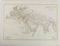
1820177230Paris. circa1820. Engraved map with original outline hand-colour 21.1 x 31.5cm original folds a few spots and a little creased but in very good condition. Latin map of the Ancient world encompassing Europe India Arabia the Middle East and North Africa by the French cartographer Jean Baptiste Poirson 1761-1831 finely engraved. . unknown
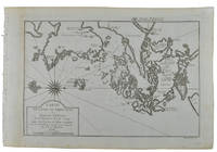
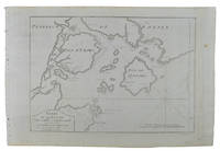
158464215Antwerp.: Abraham Ortelius. circa1584. Two engraved maps on laid paper each 30.3 x 19.5 cm printed on the one sheet 48 x 60 cm original fold attractive hand colour with related French text on verso slight toning and spotting to the margins but the maps in very good condition preserved in a modern window mount. Attractive maps of the German coast published in Ortelius' great atlas "Theatrum Orbis.". The left-hand map showing the mouths of the Elbe complete with sea monster and Eider Rivers and the coast of Schleswig-Holstein; the right-hand map of the Baltic coast with the Pomeranian islands of Rugen and Usedom. . (Abraham Ortelius). unknown
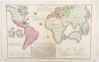
1835203763Philadelphia.: W. Marshall. Circa1835. Handcoloured engraved map 26.5 x 41.3 cms; 29.6 x 48.3 cms sheet central fold insets of "Oceanica" and "New Holland" central table some light staining in the image and margins in good condition. Eurocentrism laid bare. This 19th Century map includes a "State of Society" for each part of the world declared with a symbol to represent "Barbarous Half Civilized Civilized and Enlightened Societies" as well as noting religion and ethnicity. It includes a table of distances between chief towns or capitals and between these towns and Washington DC. Australia "New Holland" is styled principally as pagan barbarous unexplored and African a thin sliver of what is now New South Wales and Victoria is labelled civilized European and Protestant. Scarce. . (W. Marshall). unknown
1993LFA-126746906N° 291 (Juin 1993) : revue de 80 pages, format 215 x 285 mm, illustrée, brochée couverture couleurs, bon état
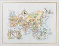
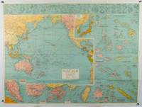
1964195995Pan American World Airways. 1964. Colour pictographic/pictorial map of Asia 23.2 x 30.1 cms gilt double-rule border printed on a folding decorative menu card 32 x 50 cms open highlighted in gilt text in English French and Japanese central fold and later central vertical crease in very good condition. Pan Am menu card for First Class passengers dubbed "The President Special" the deluxe cuisine by fabled Maxim's of Paris "Good food is the basis for true happiness". Passengers were feted with gourmet meals on bone china with silver cutlery. The witty pictorial cover-map of Asia was by French artist and commercial illustrator Jacques Liozu 1910-1974 also known for his larger scale maps. . Pan American World Airways. unknown
1875174830New York.: Harper & Brothers. 1875. Map printed in colour polar projection 21 x 27.1 cm marginal spotting and toning small edge tears to the inner margin but in god condition. Prepared for "Harper's School Geography" first published by Harper & Brothers in 1875. The map shows physical features mountains steppes plains rivers and deserts etc. together with sources of primary production: whale fisheries furs coffe tea minerals etc.The verso of the map with references and attractive line engravings part of the entry for Netherlands and Belgium. . Harper & Brothers. unknown
1940205763London.: Hutchinson & Co. Circa1940. Full colour folding map 70.7 x 93 cms; 76 x 101.2 cms sheet original folds short fold splits previous owner's neat title markings on the verso but the map in very good condition. A "Geographia" map of the war theatre in Asia and the Pacific including the northernmost coast of Australia. Showing railways and canals roads and steamer routes oilfields and pipe lines and a key to the unfederated states of Malaya. The Spratley Islands are marked as French and Thai territorial claims within French Indo China are marked. . Hutchinson & Co. unknown
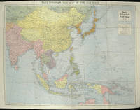
1945180206Sydney.: H.E.C. Robinson. Circa1945. Full colour inset maps principal cities and towns marked shipping routes international boundaries and railways. 99 x 73cm. Some small insect damage has been repaired on the verso visible on map as a few small lighter areas in the western Pacific. Pinpoint holes at folds paper repair along cover but a very good clean copy. From the Sydney publisher H.E.C. Robinson the firm founded in 1895 by Herbert Robinson 1857-1933 a founder of the Royal Geographical Society of Australasia. <br> <br>Although the map is undated North and South Korea are shown as divided which occurred in late 1945 and Manchuria is marked as still under Soviet occupation which only lasted until 1946 at which point it was handed over to Communist China. <br> <br>As well as what now would be considered Southeast Asia the main map shows the eastern half of India Tibet and parts of Mongolia the USSR and East Asia. Inset maps include: Caroline Islands Marshall Islands Federation of Malaya Singapore Hong Kong Taiwan Japan Hawaiian Islands Philippine Islands Midway Gaum and Wake Islands Fiji Islands Eastern & Western Samoa Santa Cruz and Solomon Islands New Caledonia Rabaul Tahiti Lord Howe etc. . H.E.C. Robinson. unknown
1976LFA-126738205Revue culturelle, économique et sociale des activités dauphinoises, savoyardes, provençales et vivaroises : 36 pages, format 210 x 270 mm, illustrée, brochée, bon état
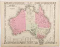
1865214355Johnson and Ward. Circa1865. Hand coloured map 32.3 x 39.7 x cms including the decorative border; 35.6 x 45.8 cms sheet key to major centres unrelated text on verso sheet age toned in very good condition. Detailed map from the leading mid 19th Century American firm of Johnson and Ward. Although Tasmania was known as such from 1856 the map refers to "Van Diemen Land". . Johnson and Ward. unknown
14446Florence, Joseph Tofani et Compagnie, Se vend chez Nicolas Pagni, 1801 ; in-8. 208 pp. - 26 cartes dépliantes. Couverture d'attente de l'époque en papier marbré. Frottements sur le dos et les plats. Inscriptions anciennes au crayon sur la première et la dernière garde. Ex-libris manuscrit sur le titre "Bigot de Préameneu" (il s'agit peut-être de Félixe Julien jean Bigot..., juriste et homme politique, un des quatre rédacteurs du Code civil de 1804).
1749136827Paris. Circa1749. Engraved map on watermarked laid paper 20 x 27.3 cm of Fuzhou and coastline of Fujian Province original folds designed by the great French cartographer Jacques-Nicolas Bellin. This map is from the impressive 15-volume "Histoire Génèrale des Voyages" compiled by Antoine François Prévost map no. 2 Vol. 6. This map shows the estuary of Yangtze River Rivière de Chang. Very light browning on sheet edges but in very good condition. . unknown
1749136826Paris. circa1749. Black and white engraved map on watermarked laid paper 20.9 x 32.7cm showing coastal area of Zhejiang Province Province de Che-kiang including Zhoushan Archipelago Isle de Chusan Zhoushan Bay Bay de Chusan and Xiangshan County Siang-chan-luen a walled city outside of upper border Ningbo Ning-po prefecture under Qing administration title cartouche lower left original folds. This map is No. 3 Vol. 6 from the impressive 15-volume "Histoire Generale des Voyages" compiled by Antoine François Prévost. Even browning mainly to the sheet edges in very good condition. . unknown
1749136795Paris. circa1749. Black and white engraved map of Quanzhou and Zhangzhou 21.1 x 30 cm here spelled Chin-chew and Chang-chew and both final words with added superscript "ou" on watermarked laid paper 25.6 x 38 cm original folds a few marginal spots simplified compass rose and a decorative fleur de lis bottom right in very good condition. Attractive map including the estuary of Quanzhou River Xiamen Emowi and Kinmen or Quemoy Quemowi island. The map was designed by the eminent French cartographer Jacques-Nicolas Bellin and here published as plate No. 22 in the impressive 15 volume compilation of voyages "Histoire Generale des Voyages" by Antoine François Prévost. . unknown
1749136781Paris. circa1749. Black and white engraved map on laid paper showing entrance to Pearl/Canton river Macao and the area which would become Hong Kong Sinn-gan-hien folded designed by the prominent French cartographer Jacques-Nicolas Bellin. This map is No. 16 Vol. 5 from the impressive 15-volume "Histoire Generale des Voyages" compiled by French novelist Antoine François Prévost. The walled city of Canton upper section is divided into areas of Tartar and Chinese. <br> <br>Some light even browning on paper added at margins good copy. Map measures 25.7 x 20.5. . unknown
1749136794Paris. circa1749. Black and white engraved plan map of Peking on laid paper folded designed by the prominent French cartographer Jacques-Nicolas Bellin. This map is No. 18 Vol. 5 from the impressive 15-volume "Histoire Generale des Voyages" compiled by French novelist Antoine François Prévost. This city map shows two areas of walled cities: Ville Tartare Imperial city and the Forbidden City and Ville Chinoise ethnic Han residential area. <br> <br>Notes A and B represents buildings within the Forbidden City. A: Lieu de Plaisance ou l'on voit une Montagne faite a la main B: Grandes Cours du Palais de l'Empereur. Two missionary buildings French and Portuguese as well as the Tower of Mathematics illustrated within Ville Tartare. Two temples illustrated side by side near the south gate of the Ville Chinoise. <br> <br>Overall in good condition very light browning on edges and darker toning along the borders of the map. Text in French. Map measures 21 x 16.4cm. . unknown
202502614S.l., Paquet, 2010 ; in-4, 48 pp., cartonnage de l'éditeur. EO tome 1.
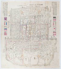
1900169765Circa1900. Large illustrated map of Beijing showing the city in the period following the invasion of the military forces of the Eight National Alliance old folds scale not given. Some scattered light foxing particularly at edges short closed tear at fold lower edge neat non acidic tape repair short section upper edge wear along folds and a couple of small unobtrusive holes with minor image loss. Blocks of text in traditional Chinese right and left upper sections stating each nation's occupied zone Japanese text title accompanies the English title along the upper section of the map. 63.7 x 56.9cm. Very good overall. A rare and significant large Japanese woodblock map of Peking Beijing issued just after the suppression of the Boxer Rebellion. Centred on the Forbidden City the map depicts Peking following the multinational suppression of the Boxer Rebellion or Yihetuan Movement of 1900. The map was issued to illustrate the areas of occupation associated with each of the powers in the Eight Nation Alliance. <br> <br>The map gives measurements of the city walls detailed names of streets and buildings and the boundaries of the inner and outer city including the forbidden city are shown with demarcation lines in pink yellow and blue. The hand coloured eight national flags of the occupation powers are featured at the right and left. <br> <br>This map is essentially a later edition of 京城内外首善全圖 a map of Beijing issued by the Qing for administrative purposes in the mid-19th century. The Japanese seized the wood blocks during the suppression of the Rebellion and subsequently pulled new impressions overprinting them additional details including flags and demarcations of areas of the city held by members of the Alliance. Versions are known in French German Japanese and as with the present example English. An attractive map of great historical interest. . unknown
179521088Brest 1795 1 feuillet avec en-tête préimprimé : Liberté Egalité AU NOM DE LA REPUBLIQUE FRANCAISE et orné d'une vignette en noir (avec symboles révolutionnaires : faisceaux d'Armes et bonnet Phrygien), manuscrit à l'encre brune sur papier vergé ligné filigrané, format 19,4 centimètres de large par 30,5 centimètres de haut, Lettre écrite à BREST, le 23 Germinal 3ème année républiquaine, signature manuscrite de THIRAT,
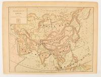
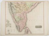
1816185242London.: Thomson. 1816. Engraved map with full handcolour 50.5 x 59.7 cms ; 53.9 x 73.8 cms sheet central fold a few minor edge tears one intruding into the top border the map unscathed marginal edgewear two corners with some loss but the map in very good crisp condition. An elegant map with great detail prepared for John Thomson's influential "New General Atlas" 1814-1821. Showing India from 20 degrees to 7 degrees north of the equator and includes the northern half of Ceylon with territorial interests attractively coloured. . Thomson. unknown
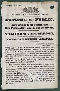
1850List2416Great Britain 1850. Broadside measuring 9 ⅞ x 15 ⅜ inches. Some chipping and wear to edge ink number written in corner two small section of loss due to improper mounting very good overall. Coat of arms of the United Kingdom above printed text. Very Good. A scarce broadside relating to British postal rates across the Panama Route through the Chagres River which supplied mail to California and Oregon beginning in 1848 before eventually being replaced by the Overland route in 1860. The service was characterized by long delay times as steamships on either side of the isthmus were often not coordinated causing major delays in the delivery. Several different steamship companies operated privately some carrying express mail. The letters were transported by canoe or pack animal across the isthmus. Postmaster General Cave Johnson began establishing post offices in California in 1848. Johnson also oversaw the transition to the prepaid delivery system. The broadside here of which we find no other records does state that postage must be prepaid and that the route can be accessed by writing “via New York†on the letters. A scarce postal history item relating to the expansion of mail services to California. We find no other records of this institutionally or in the trade. unknown
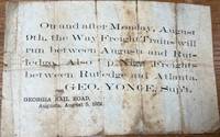
185836085Augusta: Georgia Rail Road 1858. Broadside. Fair. Broadside. Approximately 5" x 7.5". Paper is folded creased toned with two small holes. Tears at the splits. Tape repair on the blank reverse side. Fair condition only. Obscure. No other copies of this advertisement were found during a recent search. Georgia Rail Road unknown
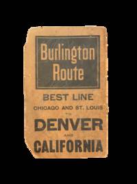
19005708Chicago: Rand Mcnally & Co 1900. Two color map 28x21" folding to 6x3.5." Few small marginal tears at folds some toning else very good. Attached to original Burlington Route folder lacking front cover. <br /> <br /> Uncommon Indiana pocket map from the Burlington Route showing roads counties cities etc. with an emphasis on railways which are listed in red at the bottom right corner. List of chief cities with populations along left margin. <br /> <br /> <br /> . Rand, Mcnally & Co unknown
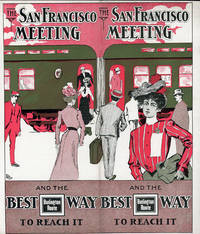
190151617N.P.: Privately printed 1901. 1901. 9 1/4" x 8" in clorful pictorial wrapper folded at center. 12 pp. Illustrations. Schedule. Overview of San Francisco along with information on its climate Chinatown The Cliff House Golden Gate Park Sutro Baths and Museum Nob Hill and side trips from San Francisco to include brief information on Monterey San Jose Paciic Grove Lake Tahoe Los Angeles etc. Information on the Burlington Route train and its railroad cars. Finally a schedule for the trip from Omaha .by way of Denver and Salt Lake City and onto San Francisco. Light soiling and light wear to the extremities. Very good. Privately printed, 1901. unknown