Aura EstradaBiblio.com

2 245 résultats
6074110271.Gpaperback. Good. Access codes and supplements are not guaranteed with used items. May be an ex-library book. paperback
30692Hamburg 1927. . Möller/Tecke I 443. - Der Hrsg. war Inhaber der Hamburg-Stade-Altländer Linie. - Rücken wenig verblaßt. Gutes Exemplar. Hamburg, 1927. unknown
19482110502150406794Shufunotomo-sha 1948. Soft Cover. Fine. Volume: 1 Shufunotomo-sha paperback
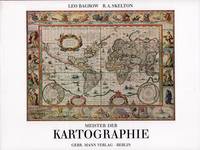
52158Berlin Gebr. Mann 1994. . Von den Karten primitiver Völker bis ins 18. Jhdt. Mit Erläuterungen zu den Abbildungen von Heinrich Winter Anmerkungen Verzeichnis der abgebildeten Karten Verzeichnis der Kartographen u. ihrer Werke Literaturverzeichnis u. Sachregister mit ca. 1500 Stichworten. - Gutes sauberes Exempöar Berlin, Gebr. Mann, (1994). unknown
0266799744.Ghardcover. Good. Access codes and supplements are not guaranteed with used items. May be an ex-library book. hardcover
0282358293.Gpaperback. Good. Access codes and supplements are not guaranteed with used items. May be an ex-library book. paperback
0332057976.Ghardcover. Good. Access codes and supplements are not guaranteed with used items. May be an ex-library book. hardcover
1391882008.Ghardcover. Good. Access codes and supplements are not guaranteed with used items. May be an ex-library book. hardcover
1996Q-0373201257Harlequin 1996-06-01. Mass Market Paperback. New. In shrink wrap. Looks like an interesting title! Harlequin paperback
20192-6200050147Editorial Académica Española 2019. Paperback. New. 344 pages. Spanish language. 8.66x5.91x0.78 inches. Editorial Académica Española paperback
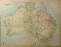
188456997Edinburgh.: A & C Black. 1884. Printed colour map of Australia some light foxing few minor tears browned edges still a clear and bright image. Map measures approximately 42 x 55cm. . A & C Black unknown
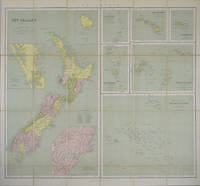
1865154409London.: George Philip & Son. 1865. 9 coloured maps by William Hughes segmented and mounted on linen 55.3 x 65.2cm. Folds into cloth covered case 17.2 x 12cm. Spine of case little faded and ribbon tie missing. Relief shown by hachures and spot heights. Philips' series of travelling maps series. Very good copy. Features a dominant map of New Zealand with 3 maps as insets to this map and 6 other maps separately shown within their own borders. The 3 inset maps are: Norfolk Island and Philip Island; Enlarged map of Auckland and the adjacent country; Enlarged plan of the country around Dunedin and the eastern portion of the Otago Gold Fields from Thomson's map. <br> <br>The 6 maps in addition to the New Zealand map are The Ladrones or Mariana Islands; The Sandwhich Islands; The Galapagos Islands; The New Hebrides and Santa Cruz Islands; The Feejee Friendly and Samoan Islands; The Marquesas Society and Low Archipelago. <br> <br>The New Zealand maps includes a list of native tribes and their locations. . George Philip & Son. hardcover
2020x-0367607409Taylor & Francis 2020. Paperback. New. 148 pages. 8.50x5.43x0.39 inches. Taylor & Francis paperback
2017x-0415786312Taylor & Francis 2017. Hardcover. New. 144 pages. 8.50x5.50x0.50 inches. Taylor & Francis hardcover
27577101-nnew. unknown
27577101like new. unknown
20172-6202235985Editorial Académica Española 2017. Paperback. New. 72 pages. Spanish language. 8.66x5.91x0.17 inches. Editorial Académica Española paperback
3659010898.Gpaperback. Good. Access codes and supplements are not guaranteed with used items. May be an ex-library book. paperback
Q-8423918068Aims Intl Books Corp 2018-02-19. Paperback. New. In shrink wrap. Looks like an interesting title! Aims Intl Books Corp paperback
186340799Cleveland: Fairbanks Benedict & Co. 1863. Stitched in original printed wrappers. 33 1 blank pp folding table. Wrappers with extremity chipping and old rubberstamp. Rear wrap detached but present. Title page with rubberstamp. Old bookplate. Good plus.<br /> <br /> This is a joint report of the Bellefontaine & Indiana Rail Road and the Indianapolis Pittsburgh & Cleveland Rail Road. <br /> Wikipedia says: "The Indianapolis and Bellefontaine Railroad I&B was an American railroad founded in 1848. It changed its name to the Indianapolis Pittsburgh and Cleveland Railroad IP&C in 1854. Its counterpart in Ohio was named the Bellefontaine and Indiana Railroad B&I. The B&I ceased to exist as an independent company when it merged into the Bellefontaine Railway in September 1864. The Bellefontaine Railway merged with the Cleveland Columbus and Cincinnati Railroad to form the Cleveland Columbus Cincinnati and Indianapolis Railway in December 1864."<br /> OCLC 12696870 11 as of March 2025. Fairbanks, Benedict & Co. unknown
1841711195.Gpaperback. Good. Access codes and supplements are not guaranteed with used items. May be an ex-library book. paperback
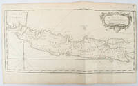
1750136782circa1750. Black and white copperplate engraving map of Java a little light even browning neat colour pencil highlighting of rivers and two settlements. Folded as issued. Good copy. 26 x 44cm. Issued in Prevost's Histoire Générale des Voyages ou nouvelle collection de toutes les relations de voyages par mer et par terre. . unknown
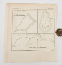
1774174260A Paris.: Chez Saillant et Nyon rue Saint-Jean-de-Beauvais Chez Panckoucke Hotel de Thou rue des Poitevins. 1774. Engraved map on laid paper 27.2 x 19.9cm 26.5 x 22.2cm sheet size edge fold slight marginal toning but in very good condition. Map of the treacherous coastal waters sandbars submerged rocks and reefs surrounding Mindanao and the Joseph Freewill Islands Mapia Atoll in the Philippines finely re-engraved for the French edition of Captain James Cook's First Voyage 1768-1771 "Relation des voyages.pour faire des decouvertes dans l'hemisphere meridional et successivement executes par le commodore Byron le capitaine Carteret le capitaine Wallis & le capitaine Cook.". . Chez Saillant et Nyon, rue Saint-Jean-de-Beauvais, [Chez] Panckoucke, Hotel de Thou, rue des Poitevins. unknown
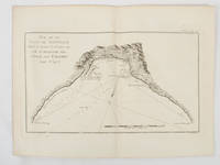
1774174257Paris.: Chez Saillant et Nyon rue Saint-Jean-de-Beauvais Chez Panckoucke Hotel de Thou rue des Poitevins. 1774. Engraved map on laid paper 18.5 x 31cm 25.6 x 34.4cm sheet size central fold slight marginal toning but a very good dark impression. Map of Bonthain Bay situated southeast of Macassar on the island of Celebes finely re-engraved for the French edition of Captain James Cook's First Voyage 1768-1771 "Relation des voyages.pour faire des decouvertes dans l'hemisphere meridional et successivement executes par le commodore Byron le capitaine Carteret le capitaine Wallis & le capitaine Cook.". . Chez Saillant et Nyon, rue Saint-Jean-de-Beauvais, [Chez] Panckoucke, Hotel de Thou, rue des Poitevins. unknown
1463351658.Gpaperback. Good. Access codes and supplements are not guaranteed with used items. May be an ex-library book. paperback