[JAMAICA AND JAVA AND BALI - MAP].Biblio.com
2 245 résultats
1900174875London and New York.: Encyclopedia Britannica. circa1900. Map in three insets after W & AK Johnston engravers with printed outline colour 18.9 x 28.9 cm central fold paper age-toned but in very good condition. Interesting map which first appeared in the ninth edition of Encyclopedia Britannica. . [Encyclopedia Britannica] unknown
2003London 1929-1933. Author of "The Road to Kashmir" and others. Total seven pages 8vo 4 and 4to 1 good condition. He discusses "The Road to Kashmir" sales etc. and "A Window on Fleet Street". He discusses at length a circular relating to the latter from John Murray which he sends not present in response to Murray's request for him to send it to "good book readers and good book buyers". Wilson is "the goodest bookseller in London". Frank Mumby describes Wilson as "one of the outstanding booksellers of the day" 1956 ed. p.235. Six items London, 1929-1933. unknown
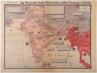
1944214362Los Angeles.: Los Angeles Examiner. April 31944. Colour pictorial map on a single newspaper leaf 37 x 50 cms; 41.5 x 54.6 cms sheet unrelated text on the verso although with an interesting account from a soldier's letter about an air raid in China toning more marked at the central fold two small splits no loss to the map edge wear with several small marginal edge tears neatly repaired on the verso with archival washi map unaffected in good condition. A dynamic map prepared and illustrated by the Examiner's art critic and editor Howard Burke covering the area surrounding India and Central Asia showing Japanese conquered territory in Malaya Thailand Indo-China and Burma; and in India British-controlled states and native feudal and protected states. <br> <br>Text boxes and pictographs give an overview of the geopolitical situation from the Allied perspective. One box notes "Chanda Bose has many adherents and fanatical followers in Bengal. They may prove to be a powerful fifth column in India". Text at lower edge opines "The situation in India is critical and has grown more so as the all-out offensive against Japan has been delayed. If the Allies do not act at once and with great force all our gains may be wiped out and the war in the Pacific prolonged indefinitely." <br> <br>The decisive and devastating bombings that were to signal such an end were four months away. <br> <br>Rare on the market. . Los Angeles Examiner. unknown
1850177528London.: The London Printing and Publishing Company. circa1850s. Lithographed map with original outline hand colour 25.8 x 33.5 cm three vignette illustrations decorative border central fold in very good condition presented in a window mount. Attractive decorative map with three vignettes by Rapkin: Yedo; a State barge in sail with penants flying--the paired oarsmen depicted through 10 small windows below deck; and Koreans in traditional costume; the map after the great mapmaker and publisher John Tallis. <br> <br>From the estate of the late collector and scholar Arthur Hacker with his pencilled catalogue mark on the verso. . The London Printing and Publishing Company. unknown
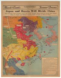
1940209821Los Angeles.: Los Angeles Examiner. 1940. Printed colour pictorial map on a single newspaper leaf 42.3 x 39.9 cms; 54.3 x 42.5 cms sheet archivally laid down on linen slight discoloration to lower centrefold and sheet slightly age-toned but in very good condition. A striking geopolitical map by Los Angeles Examiner artist Howard Burke covering China Japan Southern Russia and the northern part of French Indochina and Siam showing how the "Aggressors Divide China." Areas under Japanese occupation are shown in red and their naval blockade shown by an arc of naval vessels with vivid arrows indicating lines of supply. Text labels including sources of agricultural and raw materials provide a dynamic overview of the geopolitical situation and show the influence of American scientific illustrator and cartographer Richard Edes Harrison who argued for examining geographic issues from multiple perspectives and Los Angeles Times artist Charles Owens. . Los Angeles Examiner. unknown
19582090202120408086Kotsu an'nai-sha 1958. Soft Cover. Fine. Number of books: 1 Kotsu an'nai-sha paperback
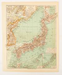
1902174898Leipzig.: Bibliographisches Institut. 1902-1908. Map printed in colour 27.2 x 21.4 cm inset colour key to territorial administration by country inset "western continuation of the main chart" including the Gulf of Tschili and Tsientsin and two insets at the foot of the map to the Kuril and the Ryuku Islands text in Geman central fold slight edge toning but in very good condition. Attractive map text in German prepared for Meyers Großes Konversations-Lexikon. . Bibliographisches Institut unknown
1945208877Chicago.: Chicago Daily Tribune. August1945. Printed colour pictorial map on a single newspaper leaf 37 x 52 cms; 43 x 59.5 cms sheet three inset maps archivally laid down on linen very good condition. Full page map published in the "Chicago Daily Tribune" after the bombing of Hiroshima and Nagasaki prior to occupation by US and Allied forces in September 1945. "This is a new map of the main islands of Japan where American occupational troops will land and establish their military rule." map text The legend notes "Places bombed by U.S. Air Forces with a red circle" and "Cities bombed by Atomic Bomb" with a red star. The main map shows the Japanese islands of Honshu Shikoku and Kyushu with the Korean peninsula. Inset maps show Hokkaido Formosa and a general map of the area. . Chicago Daily Tribune. unknown
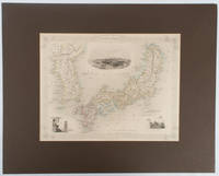
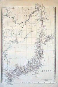
1852185246London.: Cassell Petter & Galpin. circa1852. Map with outline handcolour 42.5 x 30.1 cms; 49.2 x 34.3 cms sheet margins a little toned small corner crase but in very good condition. Very detailed map of the Japanese islands with Sakhalin above and the coast of Manchuria and Korea. . Cassell, Petter & Galpin. unknown
19722090202120100396Not Available 1972. Soft Cover. Fine. Volume: 1 Not Available paperback
19722090202120300374Not Available 1972. Soft Cover. Fine. Volume: 1 Not Available paperback
19722091502135408886Yale Publishing Company 1972. Soft Cover. Fine. Number of books: 1 Yale Publishing Company paperback
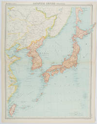
1922215880Edinburgh.: John Bartholomew & Son Ltd. 1922. Large double page map 54.2 x 43 cms map original fold some edge toning and to the fold but in very good condition. Large map prepared as plate 65 for “The Times Survey Atlas of the World” in 1922 and was prepared at the Edinburgh Geographical Institute under the direction of J G Bartholomew. The map shows Japan's territory inclusive of Korea southern Sakhalin and Taiwan. . John Bartholomew & Son Ltd. unknown
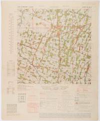
1945200411Washington D.C.: Army Map Service. First edition - revised AMS4. 1945. Army survey map printed in colour 36.7 x 36.7 cm; 58 x 48 cm sheet conversion graph glossary and administrative index to the inner margin; scale three column legend index to adjoining sheets and notes re grid references and mean declination to the foot; sheet toned a very few edge tears the map in very good condition. Wartime map produced by the US Army Map Service AMS who formed in 1942 and were at the forefront of military mapping campaigns during WWII and the post-war years. The very detailed map shows residency and administrative boundaries transportation ground and water features vegetation cultivation ruins religious sites "Graves; Chinese native" and "Cemetery; heathen Christian" walls hedges populated places built-up areas and buildings with those of iron stone wood and bamboo differentiated by colour; fishponds plantations and much more. . Army Map Service. unknown
17992111902160200187Washimi Tamotsu 1799. Soft Cover. Fine. Number of books: 1 book Washimi Tamotsu paperback
19962090502128706359Jiro Dokkyo University Open Lecture Steering Committee 1996. Soft Cover. Fine. Number of pages: 320 pages Size: 46 size Number of books: 1 volume Jiro Dokkyo University Open Lecture Steering Committee paperback
1996PD-M2R9-YGJSMeÌxico D.F: Clio 1996. Rústica. Fine. Edición en rústica tres fascÃculos en formato grande en excelente estado. Fotos disponimbles Used book in good to very good condition unless otherwise noted. All our books are thoroughly checked for issues such as missing dust jackets markings library stamps and so on. If we notice a book was misdescribed we will always let you know before shipping. We're a brick and mortar store and handle every single book with respect and care. Clio paperback
19949Halifax Yorkshire . 19 February 1847. 6pp. 12mo. In fair condition lightly aged and worn. The recipient is not identified but is a 'Brother' minister husband of the 'Mrs Walker' and father of the 'young Sam' named at the end. The letter begins: 'My dear Brother I believe you promised to write to me from Leeds and I have waited & waited until hope deferred makes my heart sick and now I send this forward like Gehazi with the prophets staff to know whether there be any voice or hearing.' He hopes that he finds himself 'at home on your Circuit' seeing 'the good work prospering': 'We expect your Super to assist at our Missionary Anniversary. on March 28th.' 'Bro. S Dunn' and 'the Division Question' are the main topic that follows others are: 'Mr Llewellyn' and his 'deputation'; 'the new Men at Bradford East' who 'surpass all that went before them - and leave us forgotten!'; 'Poor Philip'; 'Mr Talbot Thorp Arch'; 'E Brooke Esq.'; and 'the Town Society'. McCowan was the subject of an engraved portrait. In 1873 he published a memoir of his brother Peter a noted preacher. Halifax [ Yorkshire ]. 19 February 1847. unknown
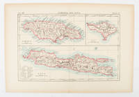
1865214355Johnson and Ward. Circa1865. Hand coloured map 32.3 x 39.7 x cms including the decorative border; 35.6 x 45.8 cms sheet key to major centres unrelated text on verso sheet age toned in very good condition. Detailed map from the leading mid 19th Century American firm of Johnson and Ward. Although Tasmania was known as such from 1856 the map refers to "Van Diemen Land". . Johnson and Ward. unknown
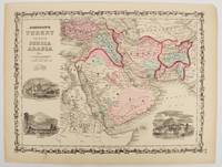
1860177019New York.: Johnson & Browning. circa1860. Engraved map 30.2 x 40.5 cm 34.5 x 45.5 cm sheet original hand-colour elaborate strapwork border three fine vignettes of Muscat Trebisond small marginal edge tears top corner chipped the map in very good condition. Most attractive decorative map of Arabia the Ottoman Empire Persia Afghanistan Beloochistan and surrounds by one of the most popular and successful 19th Century American atlas publishers. . Johnson & Browning. unknown
2006088037Centro de Matematica da Universidade do Minho 2006. Limited Edition. Paperback. Very Good. 0x0x0. A two volume complete set of books uniformly bound in the publisher's marble effect stiff card covers complete with original slipcase. Just 750 copies printed. Note: this set of books was once owned by the historian of maths and logic Ivor Grattan-Guinness thus the endpaper shows his personal bookplate. Text is mainly in Portuguese. Condition is better than very good with no stamps or marks no underlining and no splits or dents. Thus a tidy set of books in very presentable shape. Scarce. Centro de Matematica da Universidade do Minho paperback
1019765747.Ghardcover. Good. Access codes and supplements are not guaranteed with used items. May be an ex-library book. hardcover
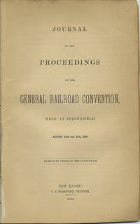
185240966New Haven: T.J. Stafford Printer 1852. First edition. Disbound. Removed from a larger volume else a very good copy chips to last three leaves of which two are blanks without loss of text. 24 pp. Sm. 8vo. To avoid ruinous rate wars railroads began to collude in earnest in the 1850s the first recorded meeting being that of the New England railroad companies in the winter of 1850-1851 followed then by this general railroad convention at Springfield Mass. called for by the principals of the New York and New Haven railroad to consider uniform train rules exchange of reports timetables and abuses in the issuance of free passes. The Ohio Railroad Convention thereafter met annually in the fifties. OCLC shows only eight locations: Lib. of Congress Amer. Antiquarian Soc. Harvard 2 Univ. Missouri Linda Hall Lib. Dartmouth and Univ. Denver. T.J. Stafford, Printer unknown
19852092902141206527light industry publisher 1985. Soft Cover. Fine. Volume: 1 light industry publisher paperback
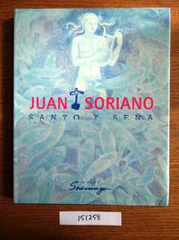
2006151258Col. Tizapan San Angel Mexico: Museo Soumaya 2006. Hardcover. VG. Light bumping to corners on top edge. Otherwise a nice clean copy. Quarto. Dark turquoise stamped cloth bluish pictorial dust jacket 183 pp. profusely illus. chiefly in color. Text is in Spanish. Issued in conjunction with an exhibition that featured work by Mexican painter sculptor and theater designer Juan Soriano 1920-2006. With six thematic and illustrated essays. The catalogue cites 158 pieces and all are pictured here; if not just in small catalogue size then also in color and nearly full page. A terrific overview of the breadth of this artist's work. One of 2000 copies. Museo Soumaya hardcover