136 résultats
16275156London George Humble 1627. Copper engraving 8.7 x 12.3 cms recent hand-colour. Some light marginal soiling. English text on verso. From the first edition of the so-called minature Speed which used maps by van den Keere to illustrate a pocket edition of Speeds text and which Humble appears to have printed to coincide with editions of the larger atlas. Map unknown
16275147London George Humble 1627. Copper engraving 8.7 x 12.3 cms recent hand-colour. Trivial soiling. English text on verso. From the first edition of the so-called minature Speed which used maps by van den Keere to illustrate a pocket edition of Speeds text and which Humble appears to have printed to coincide with editions of the larger atlas. Map unknown
16275154London George Humble 1627. Copper engraving 8.7 x 12.3 cms recent hand-colour. Trivial soiling. English text on verso. From the first edition of the so-called minature Speed which used maps by van den Keere to illustrate a pocket edition of Speeds text and which Humble appears to have printed to coincide with editions of the larger atlas. Map unknown
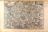
1646M11174London c.1646. Very Good. Notes: Miniature map of Poland with English text on verso.<br>Pieter van den Keere Latin: Petrus Kaerius 1571 – c.1646 was a Flemish engraver publisher and globe maker who worked for the most part of his career in England and the Dutch Republic. Size : 86x122 mm 3.39x4.80 Inches Coloring: Original Hand Coloring Category: Maps Europe Poland Lithuania; unknown
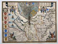
16162535London: John Speed and William Smyth 1616. Map Countye Palatine of Chester with that Most Ancient Citie Described; Hand-colored. circa 1616<br /> <br /> Hand colored map extracted from Countye Palatine of Chester Book one page 73 and 74 Chapter 37. Several modern archival repairs to verso plus an older repair at fold which has left 3 1/4-inch acid-burned strip which is obvious on verso but lesser so on recto but still evident. About 16 x 20.5 inches. Text to verso. Vibrant colors. Currently mounted to mat board. Good condition.<br /> <br /> County map of Cheshire with a large inset plan of the city of Chester at top center. The inset map is flanked by pairs of putti supporting strapwork armorial medallions. 'Arms of the Earles of Chester' along the left side of the map. Angels turning a large globe and holding an armorial shield in each of the lower corners. Includes several galleons and sea monsters. Medallion of Caesar near inset of Chester.<br /> <br /> Striking map. John Speed and William Smyth unknown
164623410London: William Humble 1646. Other. In excellent condition. 383 by 508mm 15 by 20 inches. 383 by 508mm 15 by 20 inches. Copper engraving uncolored as published. William Humble unknown
1693JC11390London: T. Basset R. Chiswell M. Wotton G. Conyers and J. Walford 1693. Paperback. Good. Disbound; 12mo; pp. 27 1 blank with large copperplate engraving on title-page. Title-page backed along the fore-edge and extending beyond the body of the text which is trimmed close frequently eliminating marginal notes. A scarce edition of this enormously popular and oft-reprinted verse attack on the Puritans first published in 1647. Wing S4898. <br/><br/> T. Basset, R. Chiswell, M. Wotton, G. Conyers, and J. Walford paperback
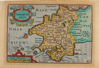
1627M9234London: George Humble c.1627. Very Good. Notes: A charming map of Pembrokeshire county in Wales during the early 17th century. English text on verso. Size : 85x121 mm 3.35x4.76 Inches Coloring: Hand Colored Category: Maps Europe United Kingdom Wales; George Humble unknown
164623420London: William Humble 1646. Other. In excellent condition. 386 by 510mm 15¼ by 20 inches. 386 by 510mm 15¼ by 20 inches. Copper engraving uncolored as published. William Humble unknown
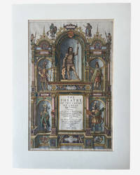
1627003914George Humble. SPEED John. A hand coloured title page from 'The Theatre of the Empire of Great Britaine'. London: George Humble 1627. Hand-coloured engraved allegorical title page from Speed's celebrated atlas of Great Britain. Image size approximately 390 x 250 mm. Mounted for display. Overall an excellent near fine example mounted verso with archival tape. This title page is from the 1627 edition on laid paper with attractive early hand-colouring depicting allegorical and historical figures representing the successive peoples of Britain including the Britons Romans Saxons Danes and Normans surrounding the architectural title framework. Imprint at foot: "Are to be sold by George Humble at the White Horse in Popes-head Alley." The engraved title page formed part of John Speed's monumental The Theatre of the Empire of Great Britaine first issued in 1611 and regarded as the first major atlas of the British Isles produced by an English cartographer. . Very Good. Soft cover. 1st Edition. 1st Printing. 1627. George Humble paperback
161221264London: Sudbury & Humble 1612. Insets of the Plan of Radnor Wales with a coat of arms compass rose/scale of miles and title in decorative cartouche. From the atlas "The Theatre of the Empire of Great Britaine". Skelton R. A. County 7. Restoration in margins otherwise very good. Copper engraving with original color re-touched. 20 x 15" plus ample margins. Sudbury & Humble unknown
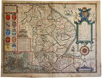
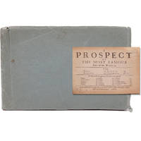
16764988LONDON: Thomas Basset and Richard Chiswell 1676. Attractive full colour example of Speed's map of Lincoln from an early 1676 edition of Speed's Theatre of Great Britain. Includes multiple coats of arms and a large inset plan of the town of Lincoln. The hand colouring is attractive and bright but there are marks and stains to the edges of the map and a little darkening. There are old pin holes to the corners where one pinned to the wall! To the rear are pages 63 and 64 with the description of Lincolnshire and list of the Hundreds in the county. The decoration of the text title identifies the edition as that of 1676. Centre fold. There are a few tape remnants to the verso and some small repairs with archival tape. 42cm x 54cm. British historian John Speed is perhaps the most famous English mapmaker of the seventeenth century. His reputation rests on two great books: The Theatre of the Empire of Great Britaine produced initially in 1611-1612 and A Prospect of the Most Famous Parts of the World published in 1627 the first general atlas of the world to be created in England. . Attrayant exemple en couleur de la carte de Lincoln de Speed tirée d'une édition ancienne 1676 du Speed's Theatre of Great Britain. Elle comprend plusieurs armoiries et un grand plan en médaillon de la ville de Lincoln. La coloration à la main est attrayante et brillante mais il y a des marques et des taches sur les bords de la carte ainsi qu'un léger assombrissement. Il y a de vieux trous d'épingle dans les coins où l'on a épinglé la carte au mur ! Au verso les pages 63 et 64 contiennent la description du Lincolnshire et la liste des centaines du comté. La décoration du titre du texte identifie l'édition comme étant celle de 1676. Pli central. Il y a quelques restes de ruban adhésif au verso et quelques petites réparations avec du ruban adhésif d'archivage. 42cm x 54cm. L'historien britannique John Speed est peut-être le cartographe anglais le plus célèbre du XVIIe siècle. Sa réputation repose sur deux grands livres : The Theatre of the Empire of Great Britaine produit initialement en 1611-1612 et A Prospect of the Most Famous Parts of the World publié en 1627 le premier atlas général du monde créé en Angleterre. Thomas Basset and Richard Chiswell unknown
16764988LONDON Thomas Basset and Richard Chiswell 1676 Attrayant exemple en couleur de la carte de Lincoln de Speed, tirée d'une édition ancienne (1676) du Speed's Theatre of Great Britain. Elle comprend plusieurs armoiries et un grand plan en médaillon de la ville de Lincoln. La coloration à la main est attrayante et brillante, mais il y a des marques et des taches sur les bords de la carte, ainsi qu'un léger assombrissement. Il y a de vieux trous d'épingle dans les coins où l'on a épinglé la carte au mur ! Au verso, les pages 63 et 64 contiennent la description du Lincolnshire et la liste des centaines du comté. La décoration du titre du texte identifie l'édition comme étant celle de 1676. Pli central. Il y a quelques restes de ruban adhésif au verso et quelques petites réparations avec du ruban adhésif d'archivage. 42cm x 54cm. L'historien britannique John Speed est peut-être le cartographe anglais le plus célèbre du XVIIe siècle. Sa réputation repose sur deux grands livres : The Theatre of the Empire of Great Britaine, produit initialement en 1611-1612 et A Prospect of the Most Famous Parts of the World, publié en 1627, le premier atlas général du monde créé en Angleterre.
1664GEN85841664. Howell James; Speed Samuel. First edition leather bound hardback; 16 219 1 pages. It is lacking the four plates but is otherwise ESTC R21017 complete the first leaf is a blank. The full calf binding has some wear and some marks and light staining it is sound. The endp apers are browning in the margins. The blank preliminary leaf and the title leaf have an owner's inscriptions. There are some marginal fingermarks and staining in places and some marginal pencil annotations. hardcover
164623419London: William Humble 1646. Other. In excellent condition. 384 by 509mm 15 by 20 inches. Copper engraving uncolored as published. William Humble unknown
1610012725London 1610. No Binding. Good/No Jacket. Attractive hand coloring. Good. Creasing to middle Japanese paper repair to various tears yellowing to paper. Includes inset view of Bath Bathe and coats-of-arms in lower corners and sea colored blue with ships. From John Speed's Theatre of the Empire of Great Britaine. Anno 1610 in lower corner but a scarce reprint circa 1690 - 1695 by "Christopher Browne at the Globe near the West End of St. Paul's Church London <br/> <br/> unknown
164623414London: William Humble 1646. Other. In excellent condition. 383 by 509mm 15 by 20 inches. 383 by 509mm 15 by 20 inches. Copper engraving uncolored as published. William Humble unknown
16518591London Printed by R.W. for Giles Calvert . 1651. 1651 4to. 8 31 1 p. Lacking A2 and A3 from the prelims. Unbound with the spine strengthened with a paper strip. Some signs of use with good margins clear of the sidenotes. Scarce with no copy in the British Library or Bodleian. London Printed by R.W. for Giles Calvert ... unknown
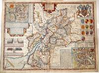
1627M11352London 1627. Very Good central fold reinforced. Notes: Detailed and decorative county map of Gloucestershire with inset plans of Bristol and Gloucester also with two battle vignettes and 10 Royal coat of arms.<br>English text on verso. Size : 388x510 mm 15.28x20.08 Inches Coloring: Hand Colored Category: Maps Europe United Kingdom England Counties; unknown
166821680London: Printed for Roger Rea 1668. Third edition. This was first published in 1631. Maps removed they were printed with the text. lacking A2 &7 B5 C2 &8 D5 E2 &8 F5 G2 &7 H5 I2 &8 K4 L1 & 6 M3 &7 and N4 &8. 1 vols. Oblong 24mo 6 1/2 x 4 inches. Later green wrappers some browning of text lacking 21 leaves else a very good copy. Third edition. This was first published in 1631. Maps removed they were printed with the text. lacking A2 &7 B5 C2 &8 D5 E2 &8 F5 G2 &7 H5 I2 &8 K4 L1 & 6 M3 &7 and N4 &8. 1 vols. Oblong 24mo 6 1/2 x 4 inches. The section on America the D gathering is lacking the first and final leaves but the comments on Virginia are present "on the East it has Mare del Nort on the North Norumbega Florida on the South and Westward the bound are not yet set.The North parts are most inhabited by our men and it is therefore called New England." Florida is "'a Pleasant Region.discovered by our English under Sebastian Cubbot 1497 but left for the Spaniard to possess.and after him the French but neither in quiet. For they warred upon each other till they left neither of them men enough to hold it". Sabin 89228n Printed for Roger Rea unknown
166821680London: Printed for Roger Rea 1668. Third edition. This was first published in 1631. Maps removed they were printed with the text. lacking A2 &7 B5 C2 &8 D5 E2 &8 F5 G2 &7 H5 I2 &8 K4 L1 & 6 M3 &7 and N4 &8. 1 vols. Oblong 24mo 6 1/2 x 4 inches. Later green wrappers some browning of text lacking 21 leaves else a very good copy. Third edition. This was first published in 1631. Maps removed they were printed with the text. lacking A2 &7 B5 C2 &8 D5 E2 &8 F5 G2 &7 H5 I2 &8 K4 L1 & 6 M3 &7 and N4 &8. 1 vols. Oblong 24mo 6 1/2 x 4 inches. The section on America the D gathering is lacking the first and final leaves but the comments on Virginia are present "on the East it has Mare del Nort on the North Norumbega Florida on the South and Westward the bound are not yet set.The North parts are most inhabited by our men and it is therefore called New England." Florida is "'a Pleasant Region.discovered by our English under Sebastian Cubbot 1497 but left for the Spaniard to possess.and after him the French but neither in quiet. For they warred upon each other till they left neither of them men enough to hold it". Sabin 89228n Printed for Roger Rea unknown books
1693JC11390London: T. Basset R. Chiswell M. Wotton G. Conyers and J. Walford 1693. Paperback. Good. Disbound; 12mo; pp. 27 1 blank with large copperplate engraving on title-page. Title-page backed along the fore-edge and extending beyond the body of the text which is trimmed close frequently eliminating marginal notes. A scarce edition of this enormously popular and oft-reprinted verse attack on the Puritans first published in 1647. Wing S4898. <br/><br/> T. Basset, R. Chiswell, M. Wotton, G. Conyers, and J. Walford paperback books
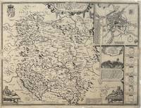
1610330332John Sudbury & George Humble 1610. unbound. Map. Original engraving. Image measures 15" x 20".<br/> <br/> Beautiful early map of Herefordshire with inset plan of the city of Hereford.The region central England is known for cider and beer production. Topography castles and churches are represented pictorially. Insets include an image and explanation of a famous 1461 battle during the War of the Roses a group of coats of arms and two images of a mapmaker at work. Verso has information and history on the county and a census of towns and "hundreds" smaller municipalities within the county. Map is in good condition despite a few scattered stains. Chips to margins not affecting the image. There is a small repari near the original fold line. <br> <br> John Speed 1552-1629 born in Cheshire and a tailor by profession until he was 50 is widely considered to be the most famous English cartographer of the 17th century. He is noted for placing England in the mainstream of map publishing an industry which was at the time dominated by the Dutch. His atlas "The Theatre of the Empire of Great Britaine" contained the first set of individual county maps of England and Wales as well as significant town plans that are in many cases the first visual records of their subjects.<br/> <br/> John Sudbury & George Humble unknown
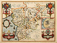
162764226London. c.1627. John Speed 1552-1629 is arguably the most famous name in early English cartography. In 1610 he published his wonderful and historic atlas 'The Theatre of Great Britain'. In 1627 he published another edition entitled 'A Prospect of The Most Famous Parts of The World' published in London by John Sudbury and George Humble. Speed based his maps on the earlier works done by Christopher Saxton and John Norden. His maps have always been keenly sought after as include many decorative features. Examples include: compass roses cherubs coats of arms mannerist style decoration prominent town plans calligraphy and well defined regional physical features. John Speed's maps proved so popular that they were issued for many years after his death. This example is of the Welsh county of Merionethshire. Size:420 x 545 mm. Copperplate engraving with later hand colour. Fair condition. Map has had repairs to lower centrefold and margin. General toning. unknown
162623758London: G. Humble 1626. Other. In excellent condition. 382 by 508mm 15 by 20 inches. 382 by 508mm 15 by 20 inches. Copper engraving hand colored in outline and wash. Original antique copper engraving hand colored in outline and wash. John Speed 1551 or 1552 28 July 1629 was an English cartographer and historian. He is alongside Christopher Saxton one of the best known English mapmakers of the early modern period.Speed was born in the Cheshire village of Farndon and went into his father Samuel Speed's tailoring later in life.While working in London Speed was a tailor and member of a corresponding guild and came to the attention of "learned" individuals. These individuals included Sir Fulke Greville who subsequently made him an allowance to enable him to devote his whole attention to research. By 1598 he had enough patronage to leave his manual labour job and "engage in full-time scholarship". As a reward for his earlier efforts Queen Elizabeth granted Speed the use of a room in the Custom House. Speed was by this point as "tailor turned scholar" who had a highly developed "pictorial sense".In 1575 Speed married a woman named Susanna Draper in London later having children with her. These children definitely included a son named John Speed later a "learned" man with a doctorate and an unknown number of others since chroniclers and historians cannot agree on how many children they raised. Regardless there is no doubt that the Speed family was relatively well-off.By 1595 Speed published a map of biblical Canaan in 1598 he presented his maps to Queen Elizabeth and in 16111612 he published maps of Great Britain with his son perhaps assisting Speed in surveys of English towns.At age 77 or 78 in August 1629 Speed died. He was buried alongside his wife in London's St Giles-without-Cripplegate church on Fore Street. Later on a memorial to John Speed was also erected behind the altar of the church. According to the church's website "His was one of the few memorials in the church that survived the bombing" of London during The Blitz of 19401941 . The website also notes that "the cast for the niche in which the bust is placed was provided by the Merchant Taylors' Company of which John Speed was a member". His memorial brass has ended up on display in the Burrell Collection near Glasgow. Wikipedia G. Humble unknown