Speed, JohnBiblio.com
136 résultats
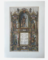
1627003914George Humble. SPEED John. A hand coloured title page from 'The Theatre of the Empire of Great Britaine'. London: George Humble 1627. Hand-coloured engraved allegorical title page from Speed's celebrated atlas of Great Britain. Image size approximately 390 x 250 mm. Mounted for display. Overall an excellent near fine example mounted verso with archival tape. This title page is from the 1627 edition on laid paper with attractive early hand-colouring depicting allegorical and historical figures representing the successive peoples of Britain including the Britons Romans Saxons Danes and Normans surrounding the architectural title framework. Imprint at foot: "Are to be sold by George Humble at the White Horse in Popes-head Alley." The engraved title page formed part of John Speed's monumental The Theatre of the Empire of Great Britaine first issued in 1611 and regarded as the first major atlas of the British Isles produced by an English cartographer. . Very Good. Soft cover. 1st Edition. 1st Printing. 1627. George Humble paperback
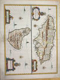
1676M7404London c.1676. Very good the lower part of the central fold reinforced and backed with acid free tissue paper for long term preservation. Notes: From Speed's A Prospect of the Most Famous Parts of the World. Size : 389x510 mm 15.31x20.08 Inches Coloring: Hand Colored Reference: Kapp: Printed Maps Of Jamaica 22<br>Campbell: Printed Maps Of Barbados MCS 21 no.5 pl. III Category: Maps West Indies Other Islands; unknown
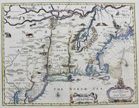
1676M8290London. : Tho: Basset; Richard Chiswell c. 1676. Very Good. Notes: A significant map of the British colonies in North America covering the east coast from Maryland and New Jersey northward through New York and New England to the French possessions in Canada. It depicts the territories acquired by the British with the capture of New Amsterdam in 1664 which changed European influence in the colonies from the Dutch to the English. It is the first appearance of name Boston and the first map to use the term New York for both Manhattan and the colony. It is also one of the first maps to show New Jersey. The map is decorated with various animals in the interior of the map two compass roses two cartouches and a coat of arms. With English text on verso that provides interesting information on the colonies. Size : 381x497 mm 15.00x19.55 Inches Coloring: Hand Colored Category: Maps United States East; Tho: Basset; Richard Chiswell unknown
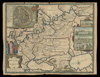
167621930<p>London: Sold by Tho: Basset in Fleet Street and Richard Chiswell in St. Pauls Church yard 1676. 405 by 515mm. 16 by 20.25 inches. Speed's map of Russia Double-page engraved map with hand-colour. A map of Russia one of the nine new maps added to the 1676 edition of Speed's 'Prospect' the first atlas compiled and published by an Englishman. Unusually this map is not in the carte-à-figure style that characterizes the 'Prospect'. Instead set in the top left-hand corner of the map is a detailed plan of Moscow with points of particular interest such as 'The Emperours Palace' and 'The Horse market' labelled. On the right-hand side is an elaborate cartouche containing views including 'Archangel' Arkhangelsk and 'A Hott House'. Accompanying text in English 'The Description of Russia' is printed on the reverse. John Speed 1552-1629 was the outstanding cartographer of his age. By trade a merchant tailor but by proclivity a historian it was the patronage of Sir Fulke Greville poet and statesman that allowed him to pursue this interest in earnest. His 'Theatre of Great Britain' first published in 1611 or 1612 was the first large-scale printed atlas of the British Isles. The 'Prospect of the Most Famous Parts of the World' from which the present work is drawn appeared in 1627 bound with the 'Theatre' and is the first world atlas compiled by an Englishman to be published in England. Engraved in Amsterdam many of the maps are anglicized versions of works by Dutch makers in distinctive carte-à-figure style featuring borders with figures in local costume and city views. This map is from the 1676 edition of the 'Prospect' published by Thomas Bassett and Richard Chiswell. While not as rare as the earlier publications this edition is perhaps the most important given that it is the first to include the nine new maps: among them Virginia and Maryland Barbados and the present example Russia. It is also the last time that the 'Prospect' was printed as an atlas. Shirley Atlases T.SPE-2f.</p> Sold by Tho: Basset in Fleet Street and Richard Chiswell in St. Pauls Church yard,
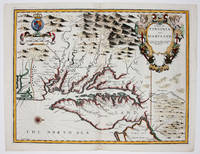
16769394London 1676. No Binding. Near Fine. 14 3/4 x 19 ¼ inches. Fine hand color; wear to bottom of centerfold else fine condition. A very attractive near-mint example. Speed's handsomely engraved work is one of the earliest English maps of the area and one of the first to demarcate the borders of colonial Virginia and Maryland. Just three years before the publication of Speed's map Augustine Herrman had conducted the first thorough surveys of Maryland at the behest of Lord Baltimore. Speed's was one of the first maps to adopt this groundbreaking cartography. However in general outline Speed still followed the prototype of Captain John Smith who conducted the first European survey of Chesapeake Bay. Speed's map "is the last major derivative of the Smith map and it is unique as an example of the transition from one basic prototype map to another. The delineation of the land area follows Smith while the toponymic prototype was the Herrman map of 1673." Verner in Tooley Mapping of America p.170 A particularly important feature derived from Herrman by Speed is the boundary line indicated by a double row of trees between Virginia and Maryland on the Eastern Shore. English text on the verso contains extensive descriptions of Virginia and Maryland. unknown
16769394London 1676. No Binding. Near Fine. 14 3/4 x 19 ¼ inches. Fine hand color; wear to bottom of centerfold else fine condition. A very attractive near-mint example. Speed's handsomely engraved work is one of the earliest English maps of the area and one of the first to demarcate the borders of colonial Virginia and Maryland. Just three years before the publication of Speed's map Augustine Herrman had conducted the first thorough surveys of Maryland at the behest of Lord Baltimore. Speed's was one of the first maps to adopt this groundbreaking cartography. However in general outline Speed still followed the prototype of Captain John Smith who conducted the first European survey of Chesapeake Bay. Speed's map "is the last major derivative of the Smith map and it is unique as an example of the transition from one basic prototype map to another. The delineation of the land area follows Smith while the toponymic prototype was the Herrman map of 1673." Verner in Tooley Mapping of America p.170 A particularly important feature derived from Herrman by Speed is the boundary line indicated by a double row of trees between Virginia and Maryland on the Eastern Shore. English text on the verso contains extensive descriptions of Virginia and Maryland. unknown books
167634894London: Thomas Basset & Richard Chiswell 1676. Copper-engraved map. Image area: 15 1/4 x 20 inches. Very good. Matted. The first state of Speed's early map of Virginia.<br/> <br/>As noted by Burden this was the first map to incorporate information from Augustine Hermann's Virginia and Maryland As it is Planted and Inhabited this present Year 1670 a landmark map of the region. While the general outlines of the map are taken from John Smith's map of 1612 much of the toponomy derives from Hermann as well as the representation of Delaware Bay which did not appear on Smith's map and a more accurate depiction of the northeastern shore of Chesapeake Bay. With very interesting text on the verso condensed from John Ogilby's America published in 1671.<br/> <br/>£Burden 456. Thomas Basset & Richard Chiswell unknown books
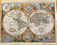
1659M9858London 1659. Very Good backed on acid free tissue paper for long term preservation. Notes: Scarce third state of Robert Walton's decorative map of the World based upon the earlier edition of John Speed's World map.<br>Double hemisphere map of the World with portraits of the four great explorers of the era Sir Francis Drake Thomas Candish Oliver Van Noort and Ferdinand Magellan.<br>California is depicted as an Island with an unusual Northwest Coast of America. The map is surrounded by smaller celestial hemispheres and the four elements with notes on the South Pole & Straits of Magellan. <br>Walton's map is rarer than John Speed's map and is of equal artistic and cartographic importance.<br> Size : 398x530 mm 15.67x20.87 Inches Coloring: Hand Colored Reference: Shirley #397. Category: Maps World; unknown
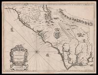
167615098London: Thomas Bassett and Richard Chiswell 1676. 380 by 505mm. 15 by 20 inches. Sheet size 408 by 530mm 19 x 21 inches. Engraved map with text on verso. A fine and attractive map of the Carolina colony. Publishers Thomas Bassett and Richard Chiswell republished English cartographer John Speed's 1552-1629 popular 1611 atlas "The Theatre of the Empire of Great Britain" in 1676. As a supplement they included new section "A Prospect of the most Famous parts of the World" which contained maps engraved by Francis Lamb of the English colonies of New England and New York Virginia and Maryland Carolina and Florida and Jamaica and Barbados. This map depicts the Carolina colony in 1676 drawing from the Lord Proprietor's Map by royal geographer John Ogilby and the explorations of John Lederer fl. 1670-1675. The map orients the West to the top and depicts the coastline from Cape Charles at the mouth of the Chesapeake Bay to the north and St Augustine Florida to the south. Looking inland the Appalachian Mountains marked as "Apalathean Mountains" cut across the top right section of the map. The present map features a cartouche where the Ogilby publication had an inset map of the Ashley and Cooper Rivers. This map is one of the first to name Charleston "Charles Town" on the banks of the Ashley River. The map correctly identifies the town on the south bank of the Ashley River whereas Speed's smaller format map of Carolina incorrectly places the town on the north banks of the river. King Charles II granted eight Lord Proprietors land in North America that extended between 31 and 36 degrees latitude later extended to 29 degrees. Lederer was a German explorer who travelled West from the East coast of Virginia in hopes of finding the Pacific and the "Sea of China" with its associated riches. He never did reach the Pacific - unsurprisingly - but his personal records of his travels influenced contemporary maps. His description of the "Arenosa Desert" reflects Lederer's memory of crossing the Carolina pine barrens in the blistering summer heat. The "Great Lake" is likely the Catawba flooded which he mistook as permanent. In total Lederer traipsed across Virginia and the Eastern coast three times making it as far as the Blue Ridge mountains. Lederer's discoveries are recorded in Sir William Talbot's translation of the explorer's account from Latin to English and published in London in 1672 as "The Discoveries of John Lederer in three several Marches from Virginia To the West of Carolina." On the verso the text describes Lederer's journeys and discoveries. Burden 457 Cumming 77 Thomas Bassett and Richard Chiswell, unknown
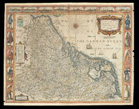
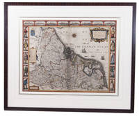
167621920<p>London: Are to be sold by Thomas Bassett in Fleet Street and Richard Chiswell in St. Pauls Churchyard 1676. 420 by 540mm. 16.5 by 21.25 inches. Speed's map of 'Low Germanie' Double-page engraved map with hand-colour. A map of 'Low Germanie' the modern-day Netherlands from the 1676 edition of the first atlas compiled and published by an Englishman Speed's 'Prospect'. A decorative border along the top of the map depicts views of major cities among them Amsterdam and Utrecht. Along each side of the map are illustrated figures in regional costume. Accompanying text in English 'The Description of Belgia' is printed on the reverse. John Speed 1552-1629 was the outstanding cartographer of his age. By trade a merchant tailor but by proclivity a historian it was the patronage of Sir Fulke Greville poet and statesman that allowed him to pursue this interest in earnest. His 'Theatre of Great Britain' first published in 1611 or 1612 was the first large-scale printed atlas of the British Isles. The 'Prospect of the Most Famous Parts of the World' from which the present work is drawn appeared in 1627 bound with the 'Theatre' and is the first world atlas compiled by an Englishman to be published in England. Engraved in Amsterdam many of the maps are anglicized versions of works by Dutch makers in distinctive carte-à-figure style featuring borders with figures in local costume and city views. This map is from the 1676 edition of the 'Prospect' published by Thomas Bassett and Richard Chiswell. While not as rare as the earlier publications this edition is perhaps the most important given that it is the first to include the nine new maps: among them Virginia and Maryland Barbados and Russia. It is also the last time that the 'Prospect' was printed as an atlas. Shirley Atlases T.SPE-2f.</p> Are to be sold by Thomas Bassett in Fleet Street and Richard Chiswell in St. Pauls Churchyard,
1626ACH8NIO8K9DULondon: George Humble 1626. Framed. 41 x 53 cm. Engraved map with hand coloured borders probably by Pieter van den Keere 1571-after 1646. Incorporating a fine compass-rose with 32 rhumb lines and names of the wind-directions a coat of arms of France a title-cartouche a legend "A catalogue of the cities et ! villages in everie Province" and an indication of scale ca. 1:1.120.000. The map is topped by 8 hand coloured miniature profiles of major cities and bordered by hand coloured figures in local costume at the left 5 male figures and right 5 female figures. Very fine and attractive map in its first edition as published in John Speed's A Prospect of the most famous Parts of the World London 1627. The very successful map was republished in 1654 in two different states and 1674. Its decorative border incorporates profiles of Amsterdam Antwerp Ghent Middelburg Groningen Zutphen Utrecht and Atrecht and figures depicting "a Gentle woman" "a Brabanders wiffe!" "a Hollanders wiffe !" "a Fishers wiffe!" "a Contreywoman!" and their male counterparts.Slightly creased with restored tears along the head and foot of the central fold. Otherwise a very good copy.l Van der Heijden 88 first state of 4. George Humble, unknown
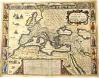
1676M10992London 1676. Very Good. Notes: English text on verso.<br>Map of the Roman Empire it is surrounded by views of the cities of Geneva Rome Jerusalem Venice and Constantinople and Alexandria and figures displaying the customary dress of Italians Egyptians Turks and Spaniards with their wives. <br><br>John Speed 1552 –1629 was an English cartographer and historian. He is known as England's most famous Stuart period mapmaker. His maps of English counties are often found framed in homes throughout the United Kingdom. For a series of maps Speed partnered with Dutch engraver Jodocus Hondius. <br><br> Size : 393x509 mm 15.47x20.04 Inches Coloring: Original Hand Coloring Category: Maps Europe Continent; Maps Asia Continent; unknown
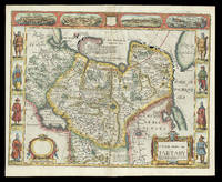
167621929<p>London: and are to be sold by Tho: Bassett in Fleet Street & Richard Chiswell in St. Pauls Churchyard 1676. 395 by 510mm. 15.5 by 20 inches. Speed's map of 'Tartary' Double-page engraved map with hand-colour. A map of Tartary encompassing parts of modern-day Siberia and Central Asia from the 1676 edition of the first atlas compiled and published by an Englishman Speed's 'Prospect'. The decorative border that runs along the top of the map depicts views of major cities as well as the house built on 'Nova Zemla' Novaya Zemlya by the explorer Willem Barentsz and his crew stranded there in 1596 here presented fending off a polar bear. Along each side are illustrated figures in regional costume. Accompanying text in English 'The Description of the Kingdom of Tartary' is printed on the reverse. John Speed 1552-1629 was the outstanding cartographer of his age. By trade a merchant tailor but by proclivity a historian it was the patronage of Sir Fulke Greville poet and statesman that allowed him to pursue this interest in earnest. His 'Theatre of Great Britain' first published in 1611 or 1612 was the first large-scale printed atlas of the British Isles. The 'Prospect of the Most Famous Parts of the World' from which the present work is drawn appeared in 1627 bound with the 'Theatre' and is the first world atlas compiled by an Englishman to be published in England. Engraved in Amsterdam many of the maps are anglicized versions of works by Dutch makers in distinctive carte-à-figure style featuring borders with figures in local costume and city views. This map is from the 1676 edition of the 'Prospect' published by Thomas Bassett and Richard Chiswell. While not as rare as the earlier publications this edition is perhaps the most important given that it is the first to include the nine new maps: among them Virginia and Maryland Barbados and Russia. It is also the last time that the 'Prospect' was printed as an atlas. Shirley Atlases T.SPE-2f.</p> and are to be sold by Tho: Bassett in Fleet Street & Richard Chiswell in St. Pauls Churchyard,
1626273459London: George Humble 1626. unbound. Map. Engraving with hand coloring. Image measures 15.25" x 19.75".<br/><br/> This beautiful carte a figures map of Tartary by John Speed presents the many geography speculations found at a time when parts of Asia were largely unexplored by Europeans. Extends from Armenia eastward to include part of North America and includes the Arctic Sea and Nova Zembla.<br><br>Korea is presented as an Island while the Kamchatka Peninsula is entirely absent. The Straits of Anian believed to be associated with the mythical Northwest Passage is identified. The Great Wall of China is depicted in a grand style south of which lies the Kingdom of China. Throughout several kingdoms important cities rivers lakes islands mountains and other topographical features are noted. These includes important cities which were part of the ancient Silk Route.<br><br>The Caspian Sea presented along its East-West Axis according to the practice of the time is identified by various names Sea of Sala otherwise Bachu called by the Russians Chualenske More in old time the Caspian and Hircan Sea. Further north Tazota Island from the Roman geographer Pliny the Elder appears in the Arctic Circle.<br><br>Beijing or Peking appears north of the Great Wall and is identified by the name Cambalu as used my Marco Polo. Interesting notations are also included throughout including one north of the Great Wall reading "In this Country is a hil out of which they dig earth called by Pliny terra Asbestus having fine veines like grasse which being spun and weaved yeeld cloth that wil nut burn in the fire".<br><br>The map is surrounded on the left and right with illustrations of the costumes and people from various parts of the region. Along the top border four views are included detailing the cities Astrakan Samarkand Cambalu and a view of the house of Nova Zembla.<br><br>Engraved by Dirck Grijp. Appears in Speed's important "Prospect of the Most Famous Parts of the World". The map is in good condition with some wear along the original centerfold. Overall foxing and some tape residue long the top margin from framing. Very good impression. English text verso.<br><br>John Speed 1552-1629 is widely considered to be the most famous English cartographer of the 17th century. His atlas "The Theatre of the Empire of Great Britaine" contained the first set of individual county maps of England and Wales as well as significant town plans that are in many cases the first visual records of their subjects. This important map of Asia is a wonderful example of his work.<br/><br/> George Humble unknown books
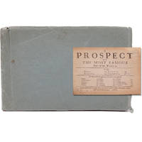
166821680London: Printed for Roger Rea 1668. Third edition. This was first published in 1631. Maps removed they were printed with the text. lacking A2 &7 B5 C2 &8 D5 E2 &8 F5 G2 &7 H5 I2 &8 K4 L1 & 6 M3 &7 and N4 &8. 1 vols. Oblong 24mo 6 1/2 x 4 inches. Later green wrappers some browning of text lacking 21 leaves else a very good copy. Third edition. This was first published in 1631. Maps removed they were printed with the text. lacking A2 &7 B5 C2 &8 D5 E2 &8 F5 G2 &7 H5 I2 &8 K4 L1 & 6 M3 &7 and N4 &8. 1 vols. Oblong 24mo 6 1/2 x 4 inches. The section on America the D gathering is lacking the first and final leaves but the comments on Virginia are present "on the East it has Mare del Nort on the North Norumbega Florida on the South and Westward the bound are not yet set.The North parts are most inhabited by our men and it is therefore called New England." Florida is "'a Pleasant Region.discovered by our English under Sebastian Cubbot 1497 but left for the Spaniard to possess.and after him the French but neither in quiet. For they warred upon each other till they left neither of them men enough to hold it". Sabin 89228n Printed for Roger Rea unknown
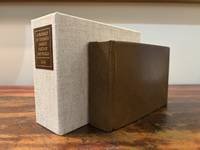
16466182London: M. F. for William Humble/George Humble 1646. First Thus. Very Good. An original travel atlas containing an early map of the world maps of the continents several countries and detailed maps of Ireland Wales Scotland and the counties in England. Bound in modern full grain leather over boards with new endpapers. Housed in a custom clamshell box using archival cloth and with a leather and gilded label on the spine. A few names on first blank in 19th century/early 20th century ink dated. Pages are toned some trimmed very close to the plate. Some infrequent soiling all text and maps are legible. With 1 folding map; a short tear to the folded part of the map. General wear to page edges. Complete with an engraved double-hemisphere map of the world 4 maps of the continents 15 other global maps and 63 maps of England Scotland Wales and Ireland. A 64th map is called out in the table of maps but Midia seems to be missing from all examples. This a miniaturized version of John Speed's folio edition.<br /> <br /> Pages: 4 206; 2; 378 Dimensions: 65/16 x 43/16 x 2. M. F. for William Humble/George Humble unknown
16279025633London: George Humble 1646 and 1627. Hardcover. Very good. Two works in one volume. Oblong octavo measuring 6 1/4 x 3 7/8 inches 16 x 9.75 cm.Rebound in full brown pebbled morocco with new tan endpapers. With custom made drop back folding clamshell slipcase in complementary tan cloth with leather spine labes stamped in gilt. First part with engraved title plus 19 engraved maps as called for. Second part with engraved title bound in upside down and remargined; Sixty - four maps called for in the index. Lacks map of England Scotland and Ireland1 and final map entitled MIDIA 64. Yorkshire map is missing section folded in from fore edge. 81 maps of 83 called for PLUS two engraved title pages. Some interior stains and foxing but still quite acceptable. A series of images is available on request. <br/><br/> George Humble hardcover books
166821680London: Printed for Roger Rea 1668. Third edition. This was first published in 1631. Maps removed they were printed with the text. lacking A2 &7 B5 C2 &8 D5 E2 &8 F5 G2 &7 H5 I2 &8 K4 L1 & 6 M3 &7 and N4 &8. 1 vols. Oblong 24mo 6 1/2 x 4 inches. Later green wrappers some browning of text lacking 21 leaves else a very good copy. Third edition. This was first published in 1631. Maps removed they were printed with the text. lacking A2 &7 B5 C2 &8 D5 E2 &8 F5 G2 &7 H5 I2 &8 K4 L1 & 6 M3 &7 and N4 &8. 1 vols. Oblong 24mo 6 1/2 x 4 inches. The section on America the D gathering is lacking the first and final leaves but the comments on Virginia are present "on the East it has Mare del Nort on the North Norumbega Florida on the South and Westward the bound are not yet set.The North parts are most inhabited by our men and it is therefore called New England." Florida is "'a Pleasant Region.discovered by our English under Sebastian Cubbot 1497 but left for the Spaniard to possess.and after him the French but neither in quiet. For they warred upon each other till they left neither of them men enough to hold it". Sabin 89228n Printed for Roger Rea unknown books
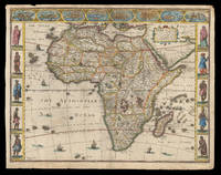
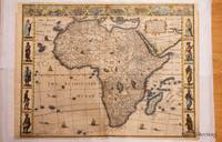
162621913<p>London: published at the charges of G. Humble 1626 but 1627-1632. 390 by 500mm. 15.25 by 19.75 inches. The first English map of Africa Double-page engraved map with hand-colour. The first English map of Africa from the first atlas compiled and published by an Englishman Speed's 'Prospect'. The map was engraved by Abraham Goos for Speed's 'Prospect of the Most Famous Parts of the World'. Along the top border are eight inset views of cities mainly in North Africa for example Alexandria Tangier and Tunis; along the side margins are inset engravings of people from different regions. The map is dense with place names rivers mountains and lakes many fictitious. While ships and sea-monsters populate the sea inland are depicted animals including zebras elephants lions and monkeys. The source of the Nile is given to the Lakes Zaire and Zaflan as according to Ptolemy. Accompanying text in English 'The Description of Africa' is printed on the reverse. John Speed 1552-1629 was the outstanding cartographer of his age. By trade a merchant tailor but by proclivity a historian it was the patronage of Sir Fulke Greville poet and statesman that allowed him to pursue this interest in earnest. His 'Theatre of Great Britain' first published in 1611 or 1612 was the first large-scale printed atlas of the British Isles. The 'Prospect of the Most Famous Parts of the World' from which the present work is drawn appeared in 1627 bound with the 'Theatre' and is the first world atlas compiled by an Englishman to be published in England. Engraved in Amsterdam many of the maps are anglicized versions of works by Dutch makers in distinctive carte-à-figure style featuring borders with figures in local costume and city views. Norwich 30; Shirley Atlases T.SPE-2a.</p> published at the charges of G. Humble,
1626320851626. John Speed was a notable cartographer and historian of Britain. This decorative map is sought after by collectors because it is the first map of Africa prepared by a notable English cartographer. His Theatre of the Empire of Great Britaine was widely influential later editions of which included this map of Africa. The map first was published in A prospect of the most famous parts of the world which was a supplement to Speed's Theatre. Somewhat paradoxically this first English map of Africa was engraved by the famous Abraham Goos from Amsterdam - he was a relative of the Hondius family and therefore knew well the Dutch maps from which this map is derived. The map has a long publication history see Betz: published first by William Humble then his son George first state with date of 1626; then Roger Rea most of whose atlases were destroyed in the Great Fire of London 2nd state. Basset & Chiswell acquired Speed's plates after 1668 and published this 3rd state of the map together with maps of the other continents and the world map. Some time before 1690 Christopher Browne acquired the plates but a map of Africa from him is not known. The map is based maps of Jodocus Hondius whose Latin annotations are translated into English and Willem Blaeu his geography. The geography is typically early seventeenth century with its legendary Ptolemaic mountains rivers and lakes; typically the Nile arises from two lakes. The Europeans knew little about the interior of Africa and therefore there are numerous illustrations of terrestrial animals 'elephants for want of towns' according to Jonathan Swift; the oceans have ships and sea serpents. The English text on verso provides a fascinating view of the European concept concerning the wildlife customs and manners of the African people. There is a description of Anthropophagi cannibals who kill their own babies to avoid the trouble of raising them; but in order to preserve their race steal children from their neighbors. The side borders of this carte-a-figure map comprise sets of 5 decorative costumes of African peoples and the top border displays prospects of eight African Cities. Some of the border illustrations are copied from Willem Blaeu. At top is a panel of panoramas and plans illustrating Tanger Ceuta Alger Tunis Alexandria Cairo Alca Mozambique and the Canary Islands. This example of the map is in attractive colour and in very good condition. a few minor chips along the edges and an old repair on the bottom joint. Acid free mounting tape on the back. unknown
1610247261Sudbury & Humble 1610. Map. Engraving with hand coloring. Image measures 15 x 20".<br/> <br/> This wonderfully decorated map depicts the island of Anglesey off the northwest coast of Wales. The island is centered on the map and labeled with towns rovers as well pictorial mountains and trees. A strapwork title cartouche features the coat of arms of England flanked by a lion and a unicorn. Below two elegant ships sail the beautifully patterned ocean surrounding an elaborate and colorful compass rose. In the lower left corner of the map showing part of Wales is an ornamental scale topped with strapwork cherubs a peacock and the country's coat of arms. A similar border frames the inset of Beaumaris in the upper right of the map which shows a plan of the port city labeled according to a key including its famous castle. The map appeared in Speed's atlas "The Theatre of the Empire of Great Britaine." It is in good condition with but margins are cropped. Expert repair to right corners. <br> <br> John Speed 1552-1629 is widely considered to be the most famous English cartographer of the 17th century. His atlas "The Theatre of the Empire of Great Britaine" contained the first set of individual county maps of England and Wales as well as significant town plans that are in many cases the first visual records of their subjects. This map of Anglesey is a beautiful example of his work.<br/> <br/> Sudbury & Humble unknown
1610247261Sudbury & Humble 1610. Map. Engraving with hand coloring. Image measures 15 x 20".<br/><br/> This wonderfully decorated map depicts the island of Anglesey off the northwest coast of Wales. The island is centered on the map and labeled with towns rovers as well pictorial mountains and trees. A strapwork title cartouche features the coat of arms of England flanked by a lion and a unicorn. Below two elegant ships sail the beautifully patterned ocean surrounding an elaborate and colorful compass rose. In the lower left corner of the map showing part of Wales is an ornamental scale topped with strapwork cherubs a peacock and the country's coat of arms. A similar border frames the inset of Beaumaris in the upper right of the map which shows a plan of the port city labeled according to a key including its famous castle. The map appeared in Speed's atlas "The Theatre of the Empire of Great Britaine." It is in good condition with but margins are cropped. Expert repair to right corners. John Speed 1552-1629 is widely considered to be the most famous English cartographer of the 17th century. His atlas "The Theatre of the Empire of Great Britaine" contained the first set of individual county maps of England and Wales as well as significant town plans that are in many cases the first visual records of their subjects. This map of Anglesey is a beautiful example of his work.<br/><br/> Sudbury & Humble unknown books
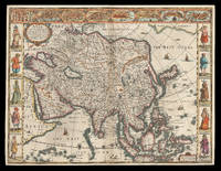
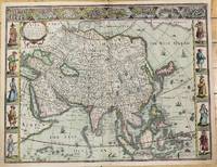
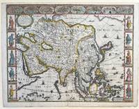
162621912<p>London: Are to be sold in pops-head alley against the Exchange by G. Humble 1626 but 1627-1632. 400 by 510mm. 15.75 by 20 inches. The first English printed map of Asia Double-page engraved map with hand-colour. The first English printed map of the continent of Asia from the first atlas compiled and published by an Englishman Speed's 'Prospect'. The map is heavily influenced by Hondius' 1623 map and inherits the gaps in his geographical understanding of Asia: Korea is presented as a peninsula and an anonymous stretch of water separates Asia from America identified only as a blending of 'The Tartarian Sea' and 'The West Ocean'. In India one finds the mythical 'Lake Ciamay' a common feature of European maps of Asia from the 16th to the 18th c. the imagined source of the major rivers of south-east Asia. The map is not without topographical accuracy however. In China the Great Wall of China is depicted described as 'a bulwarke against the suddaine infall of ye Tartars on this side'. Vignettes in the border at the top of the map depict bird's-eye views of important towns among them 'Goa' and 'Aden'. Illustrated in the borders along the sides of the map are costumed figures. Accompanying text in English 'The Description of Asia' is printed on the reverse. John Speed 1552-1629 was the outstanding cartographer of his age. By trade a merchant tailor but by proclivity a historian it was the patronage of Sir Fulke Greville poet and statesman that allowed him to pursue this interest in earnest. His 'Theatre of Great Britain' first published in 1611 or 1612 was the first large-scale printed atlas of the British Isles. The 'Prospect of the Most Famous Parts of the World' from which the present work is drawn appeared in 1627 bound with the 'Theatre' and is the first world atlas compiled by an Englishman to be published in England. Engraved in Amsterdam many of the maps are anglicized versions of works by Dutch makers in distinctive carte-à-figure style featuring borders with figures in local costume and city views. Chubb XXV; 'Mapping the Continent of Asia' 30; Shirley Atlases T.SPE-2a; Suárez 200.</p> Are to be sold in pops-head alley against the Exchange by G. Humble,
1626M10939London c.1626. Very Good. Notes: English text on verso.<br>First British map of Asia the map has 8 town plans in upper border and costumes of inhabitants of Asia in side borders. Size : 395x514 mm 15.55x20.24 Inches Coloring: Original Hand Coloring Category: Maps Asia Continent; unknown
1627337000London: George Humble 1627. unbound. Map. Engraving with hand coloring. Image measures 15 3/8" x 20".<br/> <br/> This fascinating 1626 map of Asia by John Speed is the first British map of Asia. The map presents the entire continent from the Mediterranean east to include Japan and the East Indies. The map presents many speculations and common conventions found at a time when parts of Asia were largely unexplored by Europeans.<br> <br> Korea is presented as an elongated peninsula while the Kamchatka Peninsula is entirely absent. The map shows Japan and a fairly detailed depiction of the East Indies. Further west the Caspian Sea is presented along its East-West axis as per the practice at the time. The Great Wall of China is depicted in a grand style. Throughout several kingdoms important cities rivers lakes islands mountains and other topographical features are noted.<br> <br> One of the most interesting cartographic feature on this map is the appearance of Lake Ciamay or Lake Chiamay near northeast India. This mythical lake appeared on maps from the 16th to late 18th century and was believed to be the source of the great rivers of Southeast Asia.<br> <br> Illustrations of ships and sea monsters are included. The map is surrounded on the left and right with illustrations of the costumes and people from various parts of the continent. Along the top border eight city views are included detailing Candy Goa Damascus Jerusalem Ormus Bantam Aden and Macao.<br> <br> Engraved by Abraham Goos 1590 - 1643 a master engraver was the son of Pieter Goos and Margareta van den Keere which were both from map families. Appears in Speed's important "Prospect of the Most Famous Parts of the World". The map is in good condition. Archival repair to closed tear at lower margin near centerfold. Minor staining at edges not affecting the image. English text on verso.<br> <br> John Speed 1552-1629 is widely considered to be the most famous English cartographer of the 17th century. His atlas "The Theatre of the Empire of Great Britaine" contained the first set of individual county maps of England and Wales as well as significant town plans that are in many cases the first visual records of their subjects. This important map of Asia is a wonderful example of his work.<br/> <br/> George Humble unknown