67 résultats
1693JC11390London: T. Basset R. Chiswell M. Wotton G. Conyers and J. Walford 1693. Paperback. Good. Disbound; 12mo; pp. 27 1 blank with large copperplate engraving on title-page. Title-page backed along the fore-edge and extending beyond the body of the text which is trimmed close frequently eliminating marginal notes. A scarce edition of this enormously popular and oft-reprinted verse attack on the Puritans first published in 1647. Wing S4898. <br/><br/> T. Basset, R. Chiswell, M. Wotton, G. Conyers, and J. Walford paperback books
1931140938484New York: Reilly & Lee 1931. First Edition. Near Fine/Good. First edition. 280 pp. Red ribbed cloth with black lettering. Near Fine with former owner's name on front free endpaper in Good unclipped dust jacket with panels held together on verso by archival mending tissue worn and a little chipped along edge horizontal tear in spine panel. 323 recipes in African-American dialect: green ham Sunday Night jellied salad pigs in the orchard stuffed peach salad hurry-up apple pie etc. Reilly & Lee unknown books
171312789London: Henry Overton Bassett & Chiswell 1713. Copper-engraved map with full modern colour very large marings in very good condition except for a stain at the bottom edge well away from the image. A highly decorative map of Denbighshire by one of the greatest English cartographers<br/> <br/>Denbighshire in Wales clearly a mountainous region was surveyed by Christopher Saxton which was Speed's source for this map. William Smith Pursuivant at the College of Arms was the apparent source for the coats of arms: one of which is that of Robert Dudley Earl of Leicester Queen Elizabeth's favorite. In the town plan of Denbigh in the upper right corner is a circular inset displaying what appears to be a castle. It is actually an unfinished and indeed never finished church that Leicester had tried to have built in Denbigh. Apparently his unpopularity was part of the reason the church was never completed. The map is decorated with a sea monster a classical god on horseback and a ship. Henry Overton's edition of this map includes the few roads that snaked their way through the county.<br/> <br/>cf. Hawkyard and Nicolson The Counties of Britain A Tudor Atlas by John Speed p. 73-76; Skelton The County Atlases of the British Isles 1579-1850 Map Collector's Circle part 1 #7 Speed and part 4 #92 & 121. Henry Overton, Bassett & Chiswell unknown books
1931WN23147Chicago Ill.: Reilly & Lee 1931. Spine ends slightly frayed and upper cover some damp and splashing at edges. Some offsett on ffep. Laid-in recipe and offset therefrom pp. 134-135. Dust jacket has material loss at edges folds and corners and spine sunned but jacket is intact withoout text loss and not price-clipped. . First Edition. Cloth. Fair/Poor. Illus. by Helen Lorraine. 8vo - over 7¾" - 9¾" tall. Trade. Reilly & Lee Hardcover books
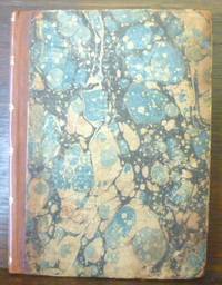
1670013648London: Printed By J.C. For Andrew Crook 1670. Rebacked over earlier marbled boards. Notes in an old hand on front pastedown regarding research of the book. Title-page has been repaired quite some time ago with 1" chip from the free edge. Title-page vignette and full-page illustration preceding the "Counter-Rat". Edges were trimmed at some point long ago with loss of a few headliners. See photos. This is an example of a "mock-poem" first published in 1621 and went through 19 editions by the end of the century. It employs octosyllabic triplets with intermittent trisyllabic lines and numerous doggerel tricks. The story of a food fight during Lent supper in the Wood Street Counter or Compter a debtors' prison in London related in a raucous mock-heroic style. See Raylor "Cavaliers Clubs and Literary Culture" pp.126-27 1994. Also cited in Wing S 4895. A scarce piece of 18th century English printing. . Later Edition. Half Brown Calf. General Cover and Corner Wear/No Jacket. Thin Small Quarto. Printed By J.C. For Andrew Crook Hardcover books
1610247261Sudbury & Humble 1610. Map. Engraving with hand coloring. Image measures 15 x 20".<br/><br/> This wonderfully decorated map depicts the island of Anglesey off the northwest coast of Wales. The island is centered on the map and labeled with towns rovers as well pictorial mountains and trees. A strapwork title cartouche features the coat of arms of England flanked by a lion and a unicorn. Below two elegant ships sail the beautifully patterned ocean surrounding an elaborate and colorful compass rose. In the lower left corner of the map showing part of Wales is an ornamental scale topped with strapwork cherubs a peacock and the country's coat of arms. A similar border frames the inset of Beaumaris in the upper right of the map which shows a plan of the port city labeled according to a key including its famous castle. The map appeared in Speed's atlas "The Theatre of the Empire of Great Britaine." It is in good condition with but margins are cropped. Expert repair to right corners. John Speed 1552-1629 is widely considered to be the most famous English cartographer of the 17th century. His atlas "The Theatre of the Empire of Great Britaine" contained the first set of individual county maps of England and Wales as well as significant town plans that are in many cases the first visual records of their subjects. This map of Anglesey is a beautiful example of his work.<br/><br/> Sudbury & Humble unknown books
1623LD8073London: Printed by John Beale for George Humble 1623. Second edition. Hardcover. Very Good. Folio 340 x 220mm. xx 1258pp. 74 numerous error in paging and register. Signatures: par.6 1st leaf blank A8; B-2H6; I4; 2K-4S6; 4T4; 4V-4Y6; 4Z8 4Z8 sic 4Z4; 5A-5T6; 5V1 of 4. Printers device of Humble on title head- and tail- pieces and initials throughout. Many in text engravings including 8 full page genealogies and numerous woodcuts throughout of coins and seals. Text in double column. Period full English calf rebacked and restored at corners in modern leather and stamped in gilt Historie of Great Britain Speed; lacking frontis. title somewhat browned and remargined text block lightly browned around edges lacking final 3 leaves of Table otherwise good. Sold as is. Large white on black bookplate of Dr. Otto Orren Fisher of Detroit Michigan to front pastedown. <br/><br/>Second Edition of Speeds Historie of Great Britain. Second Edition revised and enlarged and reissued in 1625 and again in 1627; Speeds Historie of Great Britain was originally published in 1612 with The Theatre of the Empire of Great Britaine as a companion volume though continuously paginated The Historie being the second work and the contents listing refers to the first four books which were part of the Theatre although this work books 5 - 10 is complete in itself. His account of the reign of Henry VIII p. 998 is followed by an appendix described in the running head as A Catalogue of the Religious Houses Colledges and Hospitals sometimes in England and Wales. These sections hold a wealth of information on early successors and founders of English Institutions. It was likely Speed an apt historian himself borrowed many of his materials from William Camden and was supplied by many Sir Robert Cotton Sir Henry Spelman and other antiquaries with whom he was acquainted. Although he probably had access to historical sources that are now lost to us he certainly used the work of Saxton and Norden his work as a historian is considered mediocre and secondary in importance to his map-making and the town plans he drew. Despite its many defects the Historie was very frequently cited by later writers. An important rich historical and artifactual book on Early English history. STC 2nd ed. 23046.3 Printed by John Beale for George Humble hardcover books
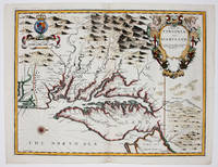
167634894London: Thomas Basset & Richard Chiswell 1676. Copper-engraved map. Image area: 15 1/4 x 20 inches. Very good. Matted. The first state of Speed's early map of Virginia.<br/> <br/>As noted by Burden this was the first map to incorporate information from Augustine Hermann's Virginia and Maryland As it is Planted and Inhabited this present Year 1670 a landmark map of the region. While the general outlines of the map are taken from John Smith's map of 1612 much of the toponomy derives from Hermann as well as the representation of Delaware Bay which did not appear on Smith's map and a more accurate depiction of the northeastern shore of Chesapeake Bay. With very interesting text on the verso condensed from John Ogilby's America published in 1671.<br/> <br/>£Burden 456. Thomas Basset & Richard Chiswell unknown books
1963151483Tooele County UT: N.p. 1963. Archive of 163 vernacular photographs including 145 in color and 18 in black-and-white capturing the 1960-1963 National Speed Trials commonly known as Speed Week at the Bonneville Salt Flats in Utah. Housed in 17 yellow envelopes with dates and names of racers written in holograph ink annotation to the rectos. <br/><br/>Offered with the archive is a brand new set of the two-volume Bonneville National Speed Trials references covering 1949-1958 and 1959-1968 respectively. The set is new and still in shrinkwrap.<br/><br/>In the early 1960s wealthy California car owners began to experiment with surplus jet engines to boost the horsepower of their cars creating distinctive bootlegged hotrods referred to as jet cars or jets designed specifically for the compacted salt surface of the flats. <br/><br/>The photographs in the archive document many early iterations of these unusual and profoundly dangerous vehicles with a particular focus on racers from southern California including Art Arfons' 8000-horsepower Cyclops which set a record for an open-cockpit vehicle 342 mph which still stands today and Mickey Thompson's Challenger I the first car to record a top speed of 400 mph. Also notable are several photographs of the streamliner entries of the Summers brothers in 1961 1962 and 1963 whose streamliner Goldenrod would go on to hold the land speed record from 1965 to 1991. <br/><br/>As a whole the photographs are bright and well-executed clearly shot with a racing insider's eye for detail. Photographs from the perspective of Speed Week attendees are scarce owing to the relatively remote locale and complete absence of accommodations for spectators making the images in the archive an uncommon intimate record of several pivotal years in the history of hotrod racing.<br/><br/>Photographs 5.75 x 3.5 inches envelopes 7.5 x 4. Some photographs with faint adhesive residue to the versos else envelopes and photographs generally Near Fine.<br/><br/>Full provenance available. N.p. unknown books
1626273459London: George Humble 1626. unbound. Map. Engraving with hand coloring. Image measures 15.25" x 19.75".<br/><br/> This beautiful carte a figures map of Tartary by John Speed presents the many geography speculations found at a time when parts of Asia were largely unexplored by Europeans. Extends from Armenia eastward to include part of North America and includes the Arctic Sea and Nova Zembla.<br><br>Korea is presented as an Island while the Kamchatka Peninsula is entirely absent. The Straits of Anian believed to be associated with the mythical Northwest Passage is identified. The Great Wall of China is depicted in a grand style south of which lies the Kingdom of China. Throughout several kingdoms important cities rivers lakes islands mountains and other topographical features are noted. These includes important cities which were part of the ancient Silk Route.<br><br>The Caspian Sea presented along its East-West Axis according to the practice of the time is identified by various names Sea of Sala otherwise Bachu called by the Russians Chualenske More in old time the Caspian and Hircan Sea. Further north Tazota Island from the Roman geographer Pliny the Elder appears in the Arctic Circle.<br><br>Beijing or Peking appears north of the Great Wall and is identified by the name Cambalu as used my Marco Polo. Interesting notations are also included throughout including one north of the Great Wall reading "In this Country is a hil out of which they dig earth called by Pliny terra Asbestus having fine veines like grasse which being spun and weaved yeeld cloth that wil nut burn in the fire".<br><br>The map is surrounded on the left and right with illustrations of the costumes and people from various parts of the region. Along the top border four views are included detailing the cities Astrakan Samarkand Cambalu and a view of the house of Nova Zembla.<br><br>Engraved by Dirck Grijp. Appears in Speed's important "Prospect of the Most Famous Parts of the World". The map is in good condition with some wear along the original centerfold. Overall foxing and some tape residue long the top margin from framing. Very good impression. English text verso.<br><br>John Speed 1552-1629 is widely considered to be the most famous English cartographer of the 17th century. His atlas "The Theatre of the Empire of Great Britaine" contained the first set of individual county maps of England and Wales as well as significant town plans that are in many cases the first visual records of their subjects. This important map of Asia is a wonderful example of his work.<br/><br/> George Humble unknown books
163230290London: John Dawson for George Humble 1632. Folio pp. 22 1237 i.e. 1281 - page numbers 1043-1086 assigned to recto only 85; includes the preliminary blank leaf; engraved frontispiece portrait of Speed by S. Savery numerous woodcut illustrations and genealogical tables throughout; numerous woodcut initials and ornaments; contemporary full calf perfunctorily rebacked in brown calf maroon morocco label on spine; several clean tears entering text no loss leaf 5a with small piece missing from fore-edge causing minor loss to a few words and numbers light occasional dampstains; a good sound complete copy. A continuation of his Theatre of Great Britaine whose contents are described in this volume as The Chorographicall Part accounting for the first 4 books. This volume The Historicall Part therefore begins with "the fifth booke" but is complete in itself. STC 23049; Graesse V 462-63; Lowndes 2471-72. <br/><br/> John Dawson, for George Humble unknown books
163224405London: Pr. by John Dawson and Thomas Cotes for George Humble 1632. Folio 33.5 cm 13.25". 10 ff. 1042 pp.; 10431086 ff. 10871237 85 index pp. lacking frontis.; illus. <br><br>Third edition of this archetypal early English history a variant of the 1631 edition. Printed with all the archaic and "curious" spellings one could hope for in such a work e.g. "Britaine" and "ye" on the title-page each page bears both roman and italic types; the text contains a number of intricate initials headpieces and tailpieces and is adorned with detailed woodcuts of kings their coats of arms and the seals and coinage of their reigns. The illustrations are as notable as the typography for quaint charm.<br>Â Â Â Â Speed 15521629 a cartographer and historian published the Historie as a continuation of his Theatre of Great Britaine both works being listed in the table of contents of this work which explains the volume's peculiar pagination and arrangement.<br>Â Â Â Â => An epitome of the "antiquarian" both in form and content this is a marvelous compendium of royal history and lore. <br>Â Â Â Â <br>Â Â Â Â ESTC S997; STC rev. ed. 23049; Graesse 46263; Lowndes 247172. Period-style calf framed panelled stamped in gilt; spine gilt extra with gilt-stamped leather title and author labels; Starr Bookworks. Light to moderate waterstaining with traces of now-arrested mildew in the form of intermittent and usually faint pink staining/spotting. Frontispiece lacking; title-page partially mounted; dedication and first few leaves of contents with inner margins reinforced. Pp. 41/42 with tear from lower margin into text lower edge of tear repaired; pp. 125/26 with lower outer corner torn away and replaced without loss of text; pp. 271/72 with lower portion replaced with loss of several paragraphs and the lower half of one image; pp. 449/50 with lower outer corner replaced with loss of lower portion of one decorated capital about three lines of text and small portion of tailpiece; pp. 597/98 with small portion of outer margin repaired with loss of one shouldernote; pp. 981/82 with an arc of the coin on the latter excised; pp. 1005/06 with portion of outer margin torn away with partial loss of one shouldernote; pp. 1041/42 with lower and outer margins partially cut away along frame of text block without loss. Pp. 1087/88 with lower portion excised text replaced in an early inked hand; pp. 1237/38 mounted with loss of an image and two paragraphs of text. One index leaf with lower outer portion excised with loss of about 15 lines of text; final index leaf with lower outer corner torn away and repaired text partially reconstructed in an early inked hand. One coat of arms drawn in by hand where the shield had been left blank. Definitely an imperfect copy; yet in fact definitely not a devastated one. Pr. by John Dawson [and Thomas Cotes] for George Humble hardcover books
1627273306London: George Humble 1627. unbound. Map. Engraving with later hand coloring. Image measures 15.25" x 20".<br/><br/> This fascinating 1627 map of Asia by John Speed is the first British map of Asia. The map presents the entire continent from the Mediterranean east to include Japan and the East Indies. The map presents many speculations and common conventions found at a time when parts of Asia were largely unexplored by Europeans.<br><br>Korea is presented as an elongated peninsula while the Kamchatka Peninsula is entirely absent. The map shows Japan and a fairly detailed depiction of the East Indies. Further west the Caspian Sea is presented along its East-West axis as per the practice at the time. The Great Wall of China is depicted in a grand style. Throughout several kingdoms important cities rivers lakes islands mountains and other topographical features are noted.<br><br>One of the most interesting cartographic feature on this map is the appearance of Lake Ciamay or Lake Chiamay near northeast India. This mythical lake appeared on maps from the 16th to late 18th century and was believed to be the source of the great rivers of Southeast Asia.<br><br>Illustrations of ships and sea monsters are included. The map is surrounded on the left and right with illustrations of the costumes and people from various parts of the continent. Along the top border eight city views are included detailing Candy Goa Damascus Jerusalem Ormus Bantam Aden and Macao.<br><br>Engraved by Abraham Goos 1590 - 1643 a master engraver was the son of Pieter Goos and Margareta van den Keere which were both from map families. Appears in Speed's important "Prospect of the Most Famous Parts of the World". The map is in good condition with some wear and verso repair along the original centerfold. Overall foxing and narrow margins. English text verso.<br><br>John Speed 1552-1629 is widely considered to be the most famous English cartographer of the 17th century. His atlas "The Theatre of the Empire of Great Britaine" contained the first set of individual county maps of England and Wales as well as significant town plans that are in many cases the first visual records of their subjects. This important map of Asia is a wonderful example of his work.<br/><br/> George Humble unknown books
16279025633London: George Humble 1646 and 1627. Hardcover. Very good. Two works in one volume. Oblong octavo measuring 6 1/4 x 3 7/8 inches 16 x 9.75 cm.Rebound in full brown pebbled morocco with new tan endpapers. With custom made drop back folding clamshell slipcase in complementary tan cloth with leather spine labes stamped in gilt. First part with engraved title plus 19 engraved maps as called for. Second part with engraved title bound in upside down and remargined; Sixty - four maps called for in the index. Lacks map of England Scotland and Ireland1 and final map entitled MIDIA 64. Yorkshire map is missing section folded in from fore edge. 81 maps of 83 called for PLUS two engraved title pages. Some interior stains and foxing but still quite acceptable. A series of images is available on request. <br/><br/> George Humble hardcover books
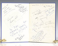
1939112422London: Macdonald and Co 1939. First edition of this overview of Hollywood. Quarto original cloth illustrated. Signed on the front pastedown and endpapers by <span class="match">Walt</span> <span class="match">Disney</span> and 13 other Hollywood actors and actresses including Chico Marx "To Pat Sincerely Chico Marx"; Pat O'Brien; "To Pat my own namesake Love Pat O'Brien Nov 21 1947; Deborah Kerr "I see a dark Stranger" on page 76 "with best wishes Deborah Kerr"; Merle Oberon "To Pat all the best Merle Oberon"; Joe E. Brown "To Pat Joe Brown." Brown was one of the most popular American comedians in the 1930s and 1940s with films like A Midsummer Night's Dream Earthworm Tractors Alibi Ike and Some Like It Hot. Jack Train "Best wishes Pat Jack Train Don't' mind if I do"; Ray Milland "Merry Xmas Pat Ray Milland." Milland is best remembered for his Academy Award-winning portrayal of an alcoholic writer in The Lost Weekend<i> </i>leading man opposite John Wayne's corrupt character in Reap the Wild Wind 1942 the murder-plotting husband in Alfred Hitchcock's Dial M for Murder 1954 and Oliver Barrett III in Love Story. <sup id="cite_ref-mgrmdmg_3-0" class="reference"></sup>Two of the signatures are pasted onto the end papers while the rest are signed directly onto the end papers with one on page 76. Near fine in a very good dust jacket. An exceptional collection of signatures in this film review book. Macdonald and Co hardcover books
16769394London 1676. No Binding. Near Fine. 14 3/4 x 19 ¼ inches. Fine hand color; wear to bottom of centerfold else fine condition. A very attractive near-mint example. Speed's handsomely engraved work is one of the earliest English maps of the area and one of the first to demarcate the borders of colonial Virginia and Maryland. Just three years before the publication of Speed's map Augustine Herrman had conducted the first thorough surveys of Maryland at the behest of Lord Baltimore. Speed's was one of the first maps to adopt this groundbreaking cartography. However in general outline Speed still followed the prototype of Captain John Smith who conducted the first European survey of Chesapeake Bay. Speed's map "is the last major derivative of the Smith map and it is unique as an example of the transition from one basic prototype map to another. The delineation of the land area follows Smith while the toponymic prototype was the Herrman map of 1673." Verner in Tooley Mapping of America p.170 A particularly important feature derived from Herrman by Speed is the boundary line indicated by a double row of trees between Virginia and Maryland on the Eastern Shore. English text on the verso contains extensive descriptions of Virginia and Maryland. unknown books
1611956London: John Sudbury & George Humble; John Dawson for George Humble 1611. 1st Edition. Hardcover. Very Good. THE EARLIEST ATLAS OF THE BRITISH ISLES AD THE EARLIEST WORLD ATLAS BY AN ENGLISHMAN. FIRST EDITION of "The Theatre"; 1611 bound with the second edition 1631 of the "Prospect" "The Theatre of the Empire of Great Britaine. was the earliest English attempt at producing an atlas on a grand scale with the first detailed maps of the provinces of Ireland the first set of county maps consistently attempting to show the boundaries of territorial divisions and the first truly comprehensive set of English town plans-a notable contribution to British topography. Perhaps as many as fifty of the seventy-three towns had not previously been mapped and about fifty-one of the plans were probably Speed's own work. A balance is struck between the modern and historical with information placed on the edges of the maps about antiquarian remains and sites and vignettes of famous battles together with arms of princes and nobles. This additional information is one of the Theatre's most significant contributions" Dictionary of National Biography. The "Theatre" is complete with engraved architectural title engraved Royal Achievements by Jodocus Hondius dated 1611 letterpress list of kingdoms and woodcut royal arms three letterpress section titles with woodcut borders three woodcut royal arms 67 double-page engraved maps most by Jodocus Hondius woodcut head- and tail-pieces and initials mounted on guards throughout. The "Prospect" was intended as a supplement to the "Theatre" and includes 22 maps of different parts of the world including the famous world map presumably by Abraham Goos and the map of America both showing California as an island. With engraved portrait frontispiece bound before "Theatre". NOTE: The "Prospect" is lacking "Invasions" but with 'Canaan' bound in its place and lacking the final text leaf on 'Civill Warres'. Also with portrait trimmed to platemark and laid down. Provenance: J.B. Speed Art Museum Louisville Kentucky bookplate. London: John Sudbury & George Humble; John Dawson for George Humble 1611; 1631. Folio 414x287mm 19th-century full calf with elaborately gilt-decorated spine. Joints repaired small chip to label. Some offsetting including on the world map some marginal repaired closed tears some maps closely cropped. Most maps including the world map with good strong impressions. John Sudbury & George Humble; John Dawson for George Humble hardcover books