( Minnesota Geology )Biblio.com
(CAPPS, SR. ) GEOLOGY OF THE ALASKA RAILROAD REGION: US,. GEOLOGICAL SURVEY BULLETIN 907 S R U SBiblio.com
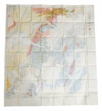
Plate 1: Seward to matanuska Cola Field; Plate 2: Matanuska Coal field to Yanert Fork; Plate 3: Yanert Fork to Fairbanks.
526001940. 3 original colour maps each c. 110 x 110 cm 40 x 45 inches folding to 20 x 12.5 cm. Natural fold creases generally very fresh and clean. Shows anchorage Big delta Blying Sound Circle fairbanks Gulkana Healy Kantishna River Kenai Livengood Mount Hayes Mount McKinley Seldovia Seward Talkeetna Talketna Mountains Tanan Tyonek Valdez etc. 1940 unknown
Robert Frew Ltd · Royaume-Uni250,00 £GB≈ 285,45 €