1 748 résultats
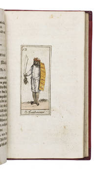
181118884Köln 1811. 12mo. Later gold-tooled half red morocco red paper over boards with the title in gold on the spine. With 24 numbered engravings 7 x 3 cm showing the peoples discussed in their traditional costumes each mounted on a blank leaf. With the engravings coloured as published as indicated on the title page. 170 4 pp. Extremely rare copy of the second edition of an already very rare work presenting the geography and anthropology of the foreign world in the form of a story told in 24 winter evenings by a father to his children. It is divided into 24 chapters each describing the inhabitants of a specific region in Africa the Americas Australia Asia and Europe each with a hand-coloured illustration. The equally rare first edition published by Bieling in Nürnberg in 1810 contains the plates from Johann Sigmund Stoy Bilder-Akademie für die Jugend 1784 while the illustrations in present anonymous edition are printed from new plates implying a possible pirated edition.It treats the Khoikhoi the inhabitants of Guinea the Caribbean Florida and Mexico the Eskimos the inhabitants of Greenland and Patagonia the "Pescherans" from Tierra del Fuego the inhabitants of New Zealand the Australian aboriginies called "New Hollanders" the inhabitants of Java and Amboina & Makassar the Moguls in India the inhabitants of Bukhara and China the Kalmyks Mongols and Buryatians the inhabitants of Tunguska and Kamchatka the Ostyaks the Samoyedic peoples and the Laplanders. Although published as a complete work by itself it was so successful that Bieling published a companion volume covering different regions in 1811: Schilderung der Vornehmsten Völker.The title-page mentions the work is written by the author of Unterhaltende Erzählungen für das erste Kindesalter 1809 apparently the same anonymous author who also wrote Julius merkwürdige Abentheuer 1813-1817 and Das goldene Buch für Kinder 1811 all published by Bieling in Nürnberg.The boards show very minor signs of wear the title-page shows traces of earlier endleaves some very minor occasional spotting. Otherwise in very good condition. An extremely rare copy of an early 19th-century German children's book teaching geography and anthropology.l WorldCat 1082152367 1 copy Universität Frankfurt; cf. GVK 2 copies of the first edition; Wegehaupt 1154 first edition lacking title-page; not in Lipperheide; Sabin etc. ABE CAT Anthropology & Ethnography ABE CAT Costumes & Uniforms hardcover
1909000140<p><strong>80 × 75 cm. Produced by KolaÄŸası Osman Nuri secretary of the Military School of Geography in 1323 AH 1907 AD.</strong></p><p>The map rarely includes a small inset map of the city of DirÊ¿iyyah in the Najd region together with additional inset maps of Medina ṬÄʾif Mecca and the harbor of Jeddah.</p> The Ottoman geographical military school, war press
60409 ½ inches 24 cm. diameter; 21 inches 53 cm. total height. Single pedestal globe with horizon ring armature & meridian all of wood wear and staining on meridian at point where fits into stand some chipping at extremities else fine; globe with vibrant original color and clear sharp patina; some abrasion & losses mostly in lower and upper extremities; overall very good plus condition.<br /><br />An attractive very capably executed table or desk globe in the distinctive style of the Delamarche firm <i>"the most successful French entrepreneurs in maps and globes"</i> Dekker/ van der Krogt. This was an original work by the son Felix who succeeded his father in the management of the firm in 1817. The globe is geographically up-to-date notably in the South Pacific and Alaska with information from then recent Russian voyages such as Krusenstern's. Related to this at the time the globe appeared and reflected on it Europeans were beginning to differentiate between various regions of the Pacific. These were based on a better understanding of cultural and other differences between the peoples of various areas encountered on these recent voyages. For example in 1831 the French explorer Dumont d'Urville proposed the use of the terms "Micronesia" and "Melanesia" for various parts of the Pacific as distinguished from Polynesia. Printed dashed lines on this globe labeled "Division Oceanique" roughly approximate the three eventually accepted divisions of what is referred to as the South Pacific though the regions are not named on the globe. Delamarche also clearly identifies on the globe the more traditional divisions of the Pacific between "Grand Ocean Boreal" "Grand Ocean Equinoxial" and "Grand Ocean Austral."<br /><br />The Delamarche firm was the first to successfully reach a fairly sizable general market of globe buyers. It accomplished this by reducing the cost of constructing globe stands and other parts while maintaining a high level of quality in the maps of their globes which are cleanly and attractively engraved. Traditional brass meridians were replaced by wooden ones and the horizon rings and armatures supporting the rings were greatly simplified and made from either wood or stiff board. Also the firm generally used simpler single-pedestal stands rather than four-legged designs. Yet as this well-preserved example demonstrates Delamarche's design and materials proved to be very durable.<br /><br />Charles-Francois Delamarche 1740-1817 the founder of the family firm was the successor of the great map and globe-making family the Robert De Vaugondys as is cited in the title of this globe. Delamarche in fact seemed to have cornered the globe market in France by also incorporating the stocks of Jean Fortin and Jean Lattre. Delamarche's son Felix took over the firm upon his father's death and managed it until 1848 when Gosselin succeeded him. The firm continued well into the latter 19th century under yet another Delamarche descendent.<br /><br />Dekker/ Van der Krogt <i>Globes from the Western World</i> pp. 63 74; Dekker E. <i>Globes at Greenwich</i> pp. 321-25; Suarez T. <i>Early Mapping of the Pacific</i> p. 25.
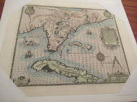
1592026339Frankfurt am Main 1591 1592. Original Antique Map . Single Sheet. Near Fine. Laid Paper. Size: Image And Border Approximately 17 7/8 Inches X 1M.5 Inches 45.2 Cm X 36.75 Cm. Debry Printed His Voyage To Virginia In 1590 As Part I Of His Works But Burden Mapping Of North America Provides No Record That A 1592 Printing Exists. This Map Has No Center Fold But Contemporary Engravings Exist Of The Offices Of The Great 17Th Century Cartographic Publishers With Row Upon Row Of Flat Drawers For Storage Of Single Maps; It Would Be Unreasonable To Believe That None Of These Unbound Maps Survived. This Appears To Be One Of Them Although The Consensus Of Modern Dealers Is That No Unfolded Large Map First Published In A Book Can Exist. Although We Have Been Unable To Locate A 1592 German Edition Of Debry We Believe This Is A Map As Issued In The 1592 German Edition Of De Bry Which Was First Published In 1591 And Subsequently Reprinted In 1592 And 1594 And In The Seventeenth Century. Small Cartouche At Lower Left Monogram With Text "Caesavece Matis. Privilegio Mdxcii" In The Plate Added After Original 1591 Printing. This Is An Unfolded Sheet Which Was Never Bound In A Book; A Strong Impression Without Damage And With Old Light Partial Coloring. Once Quite Aged Then Professionally Cleaned De-Acidified And Mounted Loosely With Archival Materials By A Museum-Experienced Conservator In About 2000. Scarce. And Now 430 Years Later It's Depicting A Hangout For Orangutans. <br/> <br/> unknown
20182081502111901673china map 2018. Soft Cover. Fine. The book is in fine condition. china map paperback
18852092902141600621Osakafu 1885. Soft Cover. Fine. Size: 109 cm x 134 cm number of books: 1 Osakafu paperback
19982091202133105715Kashiwashobo 1998. Soft Cover. Fine. Volume: 1 Kashiwashobo paperback
1526137339Florence: Impressum per hæredes Philippi Iuntae 1526. Classical geography in the renaissance An early edition of this collection of classical geographical texts including Pomponius Mela and Julius Solinus and a translation into Latin of the Greek 1st-century world geography of Dinoysius Periegetes. The text is based on the first edition of the collection printed by the Aldine press in 1518. Octavo 149 x 96 mm. Eighteenth-century vellum spine lettered in gilt marbled sides. Vellum a little wormed rear hinge reinforced sporadic light foxing and a few instances of minor soiling faint dampstain at foot of ff. 17-24 and to top right corner of ff. 185-193 and 208 minor pencilled marginalia throughout cropped early annotations to ff. 51r 52r 68r and 204r and a few other early inked lines minor paper fault to f. 135v. A very good copy. hardcover
019836654XNew. Brand new and still unused unknown
19932090202120402873Kashiwashobo 1993. Soft Cover. Fine. Number of books: 1 Kashiwashobo paperback
19842091202133202467Kashiwashobo 1984. Soft Cover. Fine. Number of books: 9 books in total Kashiwashobo paperback
18832110502150906360Masaaki Yuki Ironworks 1883. Soft Cover. Fine. Number of books: 1 Masaaki Yuki Ironworks paperback
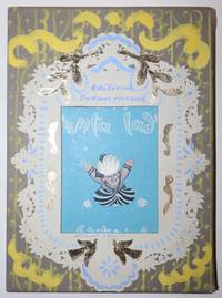
193919964Buenos Aires: Editorial Sudamerica 1939. First Editions. Outer cloth custom slipcase and chemise. Inner custom and homemade decorative decorated slipcase. Hardcover paper pastedown on boards cloth spines. Near Fine/Slipcases: Near Fine. Antonio Berni San Martin; Ballester Peña Niño; Horacio Butler Geografia; and Toño Salazar Ali Baba. A special set of Argentine children's titles from the 1930s with an unique decorative slipcase that is also an arresting specimen of Folk Art and we would regard more specifically as Latin American Rococo Folk Art as well. Folio. 36 by 27 cm. Outer slipcase: 38.5 by 28 cm. Unpaginated. All volumes have 14 leaves including free endpapers which have text inside -- in front the colophons in rear either the final text or with Geografia an Argentine map. San Martin and Niño Dios both 26 pp. Geografia has an extra page with an Argentine map inside the rear free endpaper. All four have deliciously colored illustrations on every page title pages included. Sometimes there are two illustrations on a page but there are many illustrations that are spread between the two facing pages in a variety of ways. The variety of ways in fact are part of what make the layouts so visually compelling in this series. The illustrations are stylistically varied from one volume to the next as to be expected with four different illustrators responsible. Whimsicality even a light-hearted spirited goofiness characterizes the illustrations of Ali Baba probably the volume most beloved by readers and the Geografia has the playfulness of many a fun map. The El Nino Dios is a sort of outlier surely because of its ponderous subject matter. Its artwork has the sharp and jagged angles of modernist stained glass such as one might find in a Bauhaus-inspired church and it's the one volume in which the palette is also not bright and lively. The homemade slipcase to elaborate further uses doily paper with lace designs gold foil paper and paint broadly applied to frame its cut-out window on the front and create a decorative field evocative of Colonial era ornamentation from South America. The chemise has a Armorial book plate mounted this being from Francis Bayard Rives 1890-1969 a New York attorney and blueblood Social Register listee. Corners of the four volumes are generally lightly bumped. The San Martin volume and to a lesser extent Ali Baba have evidence of bumping on their upper corner leaves but even in San Martin this is a minor cavil. Ali Baba has a tiny spot of paper pastedown loss on its front cover. The paper can also be worn down along the edges of all the volumes. Ali Baba's leaves have a hint of gentle waviness. Otherwise all volumes are immaculate. The outer slipcase does show wear with some fraying of its threads along edges. Overall this is a beautifully preserved set and a handsome set by any standard. Editorial Sudamerica hardcover
19842091502135707161Kashiwashobo 1984. Soft Cover. Fine. The book is in fine condition. Kashiwashobo paperback
19872110502150903065Kashiwashobo 1987. Soft Cover. Fine. Volume: 1 Kashiwashobo paperback
19322080502106917256Not Available 1932. Soft Cover. Fine. The book is in fine condition. Not Available paperback
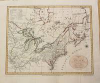
1792M1466Dublin: John Jones 1792. Very Good. Size : 330x410 mm 13x16.125 Inches Coloring: Original Outline Coloring Category: ; Maps North America Great Lakes; Maps Canada John Jones unknown
1742SZEPEBKS007524ILondon: John and Paul Knapton 1742. Hardcover. Good. Title continues: " . With a Sett of Maps Engraven from Cellarius. Designed for The Use of Schools and of Gentlemen who make the Antient Writers their Delight or Study. / Translated from the French of Mr. L'Abbe Du Fresnoy with great Additions and Improvements from Ptolemy Strabo Cellarius &cc. To which is added a Large Index." - Large wide 8vo. - vi615739 pp. plus 33 double-page plates with large margins. - Contemporary 3/4-leather with marbled paper boards corners somewhat worn edges of spine slightly cracked spine with 5 raised gilt bands title in gilt on green leather label. Front cover separated from binding - Some water stain especially in "Italia Antique" With an engraved heraldic bookplate with the motto: "COMME JE FCS" - In English. - "Additions and Corrections" on Page vi. - With 33 double-folded maps R. W. Seale sculp. Small tears at bottom of second fold without loss in 5 maps; a bigger tear but again without loss. in Map xxii: "Asia Minor". <br/> <br/> John and Paul Knapton hardcover
1606182261606. Persici Vel Sopho Rum Regni Typus 1606 presents an early seventeenth century European cartographic rendering of Safavid Iran documenting how Persia was geographically understood and visually represented during the height of Safavid political authority. The map identifies the region within a broader network of imperial borders extending toward Russia and India and includes Kabul within the Persian sphere reflecting contemporary geopolitical conceptions rather than modern national boundaries. The Caspian Sea is depicted horizontally indicating an early stage in European geographic knowledge prior to the standardization of its vertical orientation. The Persian Gulf appears under the Latin designation "Sinus Arabicus" demonstrating period naming conventions and the fluidity of regional terminology in European mapmaking. Produced during the Age of Discovery the map participates in the circulation of geographic knowledge that accompanied expanding diplomatic commercial and intellectual engagement between Europe and the Islamic world.<br /> <br /> Hand colored engraved map dated 1606 measuring approximately 21.5 x 18 inches with text in Latin. The composition includes detailed delineation of mountain ranges waterways and settlements the latter indicated by small colored markers distributed across the landscape. Decorative cartouches frame descriptive text including a prominent circular panel reading "Persici Vel Sopho Rum Regni Typus." Verso contains French text referencing "le royaume des perses of l'empire des sophy" further situating the map within a European print context of translation and dissemination. The map is rendered in shades of pink gold and turquoise with coloring applied by hand at an undetermined date.<br /> <br /> Issued during the Safavid dynasty which maintained extensive political and dynastic connections across the Caucasus and surrounding regions the map reflects both European interest in Persia and the integration of Persian territories into broader early modern world mapping traditions. Its geographic features and naming conventions provide evidence of evolving European understanding of the Middle East and Central Asia during a period of intensified cross cultural contact. Central fold mark present with a few small tears along the lower edge not affecting image or text. One small ink mark at left margin also not affecting the image. Colors remain strong and impressions clear. Overall very good. unknown
1776015982Circa 1776: Millar 1776. 1st Edition 1st Printing. Framed. Very Good/No Jacket. 15 1/2" x 14. Fine revolutionary era map of North America showing the British colonies with Nova Scotia part of the same British group of colonies as the Future United States with the southern colonies extending to the Ohio and Mississippi rivers. A clean complete copy with three folds as issued. <br/> <br/> Millar unknown
199823519Reyjavík: Iðunn 1998. Book. Very Good. Hardcover. First Edition. 4to - over 9¾" - 12" tall. 701 pages. Useful bibliography at pages 699-701. Icelandic text throughout. Overseas customers please email for shipping quote - this book weighs 3.7kg. Iðunn Hardcover
1938ZB445459Mexico D.F.: Instituto Panamericano de Geografia e Historia 1938-1962. volumes 1-54 an uninterrupted run of complete volumes bound ex library very good. - If you are reading this this item is actually physically in our stock and ready for shipment once ordered. We are not bookjackers. Buyer is responsible for any additional duties taxes or fees required by recipient's country. Photos available upon request. Mexico, D.F.: Instituto Panamericano de Geografia e Historia unknown
185459626Edinburgh & London: William Blackwood & Sons 1854. Folio. 12 x 15 in. 122 pp. all text w/in engraved ruled borders. Double-page hand-coloured steel-engraved frontisp. map 24 steel-engraved hand-coloured maps 1 text map. Contemporary half-maroon-coloured sheep over plum-coloured cloth gilt lettering on front cover & spine pale yellow clay-sized endpapers a.e.g. very slight occasional interior thumb soiling or dustsoiling minor scuffing to fore-edges wear to corners rear hinge starting still VG copy from library of Edwin Corbold 1827-1921 Independent Minister later Congregational Reverend and temperance supporter at Purley in Surrey. First “Reduced†edition of the first physical atlas ever published in England. Johnston 1804-1871 explains in his preface the four sections of Geology Hydrology Meteorology and Natural History originally Phytology & Zoology which were subsequently reduced in order to serve as a very popular educational atlas. Each section includes beautifully engraved maps and explanatory sections and the large Palaeontological map of the British Islands with extensive colouring and added notes by Edward Forbes. Johnston’s work reflected not only the increased interest in mapping geological zoological and biological distributions but also focused on the measurement of climate and environmental factors. William Blackwood & Sons, hardcover
1610022406London: John Spede Speed John Sudbury Georg George Humble 1610. First Edition . Single Folded Sheet. Near Fine/No Jacket. Image 20 1/2' x 15". 1610 date in both the title block and the printing information block. Original two page map from Speed's atlas in a very strong impression. Very attractive later color coastal water outlines blue with brown along land coastlines inset maps of Bangor and Caernarvon in light blue and orange borders in red shields in red all details nicely colored. Near fine print and coloring strong no tears or repairs very slight dust/soiling in small area in margins adjacent to center fold. Nicely framed with double glaze displaying the atlas pages 123 and 124 on the reverse. <br/> <br/> John Spede (Speed), John Sudbury, Georg (George) Humble unknown
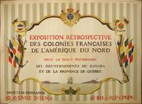
1929265324Paris: Société de Géographie 1929. Jean Kerhor. Original poster. Color lithograph. 22 x 29.25 inches.<br/> <br/> Exhibition poster reading: "Retrospective exhibition of French Colonies in North America under the patronage of the Governments of Canada and the Province of Quebec". Text is located centrally within a cartouche and surrounded by three coats of arms to the top - those of New France Quebec and Canada - and a branch of three maple leaves at the bottom. Flags hang at either side along with weaponry and nautical equipment from the colonial period. At the base of the cartouche is an illustration of a ship at sea. Illustrated by Jean Kerhor. Dated April-June 1929. Issued by the Societe de Geographie 10 Avenue d' Iena. In good condition showing some wear and minor loss along original folds. Lined with archival paper.<br/> <br/> Société de Géographie unknown