MEARES JohnMareMagnum

122 198 résultats
In-16 gr. (mm. 188x130), 4 volumi, mz. pelle coeva, fregi e titolo oro al dorso (restauri), pp. X,264; XV,212; X,238; (4),VIII,276; molto ben illustrati da 22 tavole incise in rame fuori testo fra cui: una (più volte ripiegata.) “Carta del Mar Pacifico del Nord che comprende la costa Nord-Est d’Asia e la costa Nord-Ouest d’America, riconosciute nel 1778 e 1779 dal Cap. Cook e più particolarmente ancora nel 1788 e 89 dal Capitano Gio. Meares” - 7 portolani - 10 belle vedute (3 ripiegate) - ritratti di indigeni, ecc. Vi sono pure contenuti un “Vocabolario geografico delle città, isole, ecc. accennate nei viaggi di Meares” e un “Piccolo vocabolario di marina”. "Prima edizione italiana" di questa importante opera del navigatore inglese John Meares (1756 ca.-1809). Oltre ai viaggi dalla Cina all’America nel 1788 e 1789, che formano la parte più importante dell’opera, il Capitano Meares descrive anche il viaggio effettuato col vascello "Nootka" da Calcutta alla Costa Nord-Ovest d’America, negli anni 1786-87”, inclusa l’esplorazione della regione intorno alla Baia del Principe Guglielmo (Alaska). Quest’opera, con le sue interessanti illustrazioni e i numerosi documenti storici, è di grande importanza anche per lo studio dei primi commerci di pellicce che ebbero origine lungo la costa del Nord-Ovest e del grave conflitto che scoppiò fra Inglesi e Spagnoli a questo riguardo. Cfr. “The Hill Collection of Pacific Voyages”,1126 con dettagliata descriz. della prima ediz. inglese del 1790: “.. This important narrative.., gives a very full account of the Indian nations of Northwest America, describing their villages, languages, manners, and customs. It also contains a separate account of the voyage of the "Iphigenia Nubiana", commanded by Captain William Douglas, which visited the Sandwich Islands as well as Nootka Sound”. Seguìrono quindi una edizione francese (Parigi 1794) e una italiana (Firenze, 1796). La ns. copia manca del ritratto dell’A. ma contiene 2 tavole in più rispetto agli esemplari posseduti dalle biblioteche italiane (cfr. ICCU). Pagine ingiallite per la qualità della carta altrimenti ben conservato, con barbe.
150258037(Venedig, Albertino da Lessona, 14. Mai 1502). 4°. 24 num. Bll., Mod. Pgmt. aus altem Material.
In-8 p. (mm. 202x123), 8 volumi di testo + Atlante in-4 p. (mm. 319x242), rilegati in piena pelle coeva (alc. lievi mancanze), decoraz. e tit. oro su due tasselli al dorso, tagli marmorizzati (i voll. di testo) e tagli dorati (l’Atlante), dentelles dorate ai risguardi, pp. XL,422; (4),490; (4),492; (4),499; 448; 455; 448; (4),VIII,463. Il volume 8° - “Appendix” - contiene “les descriptions des Animaux et des Végétaux observés dans les voyages du Professeur Pallas, et cités ou mentionnés dans les volumes précédens; Avec des notes et observations par le C. Lamarck, Professeur de Zoologie au Muséum national d’Histoire naturelle”. L’Atlante raccoglie 107 (su 108) belle tavole inc. in rame, di cui: 1 grande carta divisa in due fogli più volte ripieg. “de l’Empire de Russie, d’après la nouvelle division de cet Empire en quarante-deux Gouvernemens” // 10 carte geografiche (di cui 6 più volte ripieg.) // 1 veduta de “la Residence d’Ablaikit” (ripieg.) // 11 tavv. di costumi e idoli // 8 tavv. (di cui 1 ripieg.) di antichi monumenti, geroglifici, etc. // 9 tavv. di animali, storia naturale, etc., // 67 (su 68) tavv. di botanica (di cui 22 ripieg.). "Manca la tav. 74". Seconda edizione della traduzione francese di questo resoconto di viaggi condotti per tutto l'Impero Russo (il primo nel 1769-1774, il secondo nel 1793-1794) da Simon Peter Pallas, professore dell'Accademia di Scienze di San Pietroburgo e amico della zarina Caterina II. Cfr. Brunet,IV,325 - Graesse,V,109. “Peter Simon Pallas (1741-1811), naturalista tedesco. Lavorò per qualche anno nei musei di Olanda e Inghilterra, poi fu chiamato dalla Russia a prender parte ad una spedizione. Fu uno dei più eminenti esploratori del sec. XVIII, e le collezioni zoologiche, geologiche, botaniche, archeologiche ed etnologiche che raccolse durante le sue spedizioni furono di notevolissima importanza. la sua opera fornisce una massa enorme di osservazioni isolate sui modi di sussistenza delle popolazioni, sulle miniere, sulla caccia e la pesca, sulle formazioni steppose (primo tentativo di suddivisione della Russia in provincie botaniche), sulle terre nere (da lui così battezzate), sul clima (specialmente del basso Volga), sulla formazione delle montagne (osservazioni sui graniti in rapporto alle eruzioni), sul terreno gelato della Siberia. A lui si deve pure una serie di ricerche sull'antica unione del Mar Nero, Caspio e Aral, di cui è data per la prima volta una spiegazione plausibile” (cfr. Enciclopedia Treccani,XXVI, p. 122). Solo qualche rara e lieviss. fioritura, altrimenti esempl. ben conservato.
1704417061Amstelaedami, Halma, 1704. Fol. M. gest. Tit., 11 doppelblattgr. Kpfr.-Ktn., 1 gest. Tit.-Vign., 2 gest. Widmungsbl. u. 1 gest. Textvign. 5 Bl., 332, 72 S. Ldr. d. Zt. a. 7 Bünden, m. Rsch. u. floraler Rverg. Rücken fachmänn. restauriert. Einbd. leicht beschabt. St. a. Tit. u. Vortit. Teils leicht gebräunt, ansonsten sehr gut erhaltenes Exemplar.
1895ALPI0161Wien, Ed. Hölzel 1895. 34 x 26,5 cm. Textband : IV, [8] Bl., 152 S., [24] Bl., 90 Textbilder; Atlasband : 132 Atlastafeln (38 Lichtdrucke, 10 Photolithogr., 84 Autotypien). Orig.-Halblederbände mit Einbandgoldprägung, umlaufender Rotschnitt. Leder an den Kanten etw. berieben, Tafelband im Bund etwas gelockert. Im Text sauber u. fleckenfrei. - Differenzbesteuert Dem Geographen Friedrich Simony (1813-1896) ist die Erschließung des Dachsteingebietes zu verdanken. Die vorliegende Publikation stellt die Krönung seiner Lebensarbeit dar. Die Abbildungen (insbesondere) des Atlasbandes sind von bestechender Detailtreue und Unmittelbarkeit; derartiges kann durch die heute gebräuchlichen Reproduktionsverfahren nicht mehr erreicht werden (Kollateralschaden der Digitalisierung).-
In-16 gr. (mm. 197x135), cartoncino rustico mod., 4 cc.nn. (frontesp. e indice), 44 cc.num.; al frontespizio grande vignetta xilografata con la bellissima marca tipografica su fondo nero; al verso dedica del curatore Jodicus Badius e la data “ad idus iulias Anni. M.D.III”. L’opera è suddivisa in 65 capitoli. Giunta sino a noi col nome di "Collectanea rerum memorabilium" è nota anche col titolo di "Polyhistor" e "De memorabilibus mundis". “L’opera è una specie di descrizione della Terra o di corografia. Essa inizia con un’introduzione (cap. I) che si può dividere in due parti: la prima dedicata a Roma e alla storia romana fino ad Augusto; la seconda all’uomo (antropologia e fisiologia). Col 2° capitolo comincia la vera e propria descrizione: sono esaminate l'Italia, la Grecia, le regioni intorno al Mar Nero, la Germania, la Gallia, la Britannia, la Spagna, le province dell’Africa, l'Arabia, l'Asia Minore, l'India e l'impero dei Parti. L’opera non vuole essere rigorosamente scientifica, ma piuttosto una raccolta di ‘curiosità’, con speciale riferimento ai caratteri fisici e sociali dei popoli esotici, agli animali, ai vegetali e ai minerali. L’autore si è proposto di scrivere un libro di piacevole lettura: ma in realtà lo stile è freddo e artificioso. Sebbene Solino non citi mai le fonti, i tre quarti del trattato appaiono desunti dai libri III-XIII e XXXVII della "Storia naturale" di Plinio il Vecchio. Oltre a Plinio il Solino ha tenuto presenti la "Corografia" di Pomponio Mela e altre opere perdute. Non mancano nei "Collectanea" notizie a noi altrimenti ignote; e perciò l’opera ha ancora qualche importanza. Il trattato ebbe nel Medioevo, dal V al XV sec., grande fortuna. Di Caio Giulio Solino sono ignote la patria e l’età in cui visse. Probabilmente nacque e dimorò a Roma e fiorì verso la metà del III sec. d.C.”. Così Enciclopedia Treccani,XXXII, pp. 77-78. Esemplare ben conservato, con antica firma di apparten. al frontesp. Rara edizione.
In-24 gr. (mm. 148 x 205), mz. pergamena antica, fregi e titolo oro su tassello al dorso, pp. 44 di descrizione, testo su due colonne, con 230 tavole inc. in rame f.t. di cui: 1 frontespizio figurato, 1 indice generale, 1 carta geografica della Francia, 10 titoli e 8 indici, e con 209 "cartes, plans et profiles des principales villes des provinces de: Bourgogne (21 tavole) - Dauphiné (38) - Principauté d'Oranges et contat de Venaissin (4) - Provence (17) - Languedoc (45) - Villes de Foix & Bearn (6) - Guyenne (21) - Poictou (24) - Loire (17) - Beaulce (16)". La carta geografica della Francia, ripiegata, è mutila di una piccola parte. Cfr. Christie's "Antique Maps", p. 127: "Nicolas Tassin (1633-55) was appointed royal cartographer at Dijon before setting up as an engraver in Paris where he issued various collections of small maps and plans of France, Switzerland, Germany and Spain" - Tooley, p. 610. Nel ns. esemplare: frontesp. restaur. e con tracce d'uso; restauri margin. per piccole manc. o fori di tarlo sulle carte di testo; antiche note mss. al verso di numerose tavv. ma complessivam. ben conservato.
169064878Frankfurt-Leipzig, Christoph Wohlfart, 1690. 8°. Mit gest. Frontispiz. Titel in Rot u. Schwarz. 15 Bll., 1118 S., 32 Bll. - Angeb. - 2) [Leopold, I., Kaiser]. - Parschitz, Christoph. Dyodekas anagrammatica, è floribus indelebili nomini inscriptis, Magnanimi Leopoldi Imperatoris invictissimi Caesaris semper Augusti contexta; longissimis, ac largissimis manibus devotissime submissa [...]. Wittenberg, Hake, 1702. 24 nn. Bll. - Angeb. - 3) Ders. Tabella Hungariae Ducum et Regum Christianorum in qua eorum ortus & ocassus, regnorum accessiones et avulsiones, provinciarum incrementa et decrementa, bella domestica et extranea, cum varia vicissitudine temporum, brevi penicillo delineantur [...]. Ebda., [1702]. Mit 2 kolor. Vignetten. 7 Bll., 297 S., 13 Bll. - Angeb. - 4) Gregorii, Johann Gottfried. Das jetzt florirende Thüringen, In seinen Durchlauchtigsten und Ruhmwürdigsten Häuptern. Erfurt, Hieronymus Philipp Ritschel, 1711. Mit gest. Frontispiz. Titel in Rot u. Schwarz m. Holzschn.-Vignette. 224 S., Pgmt. d. Zt. m. durchzogenen Bünden u. handschriftl. Rückentitel.
182010470(Vermutlich Graz, Selbstverlag, um 1820). 22 auf Kartonblättern montierte Lithographien von Krell bzw. Denzel. Kl.-8°. Lose in Pp.-Schuber um 1920 (leicht bestoßen und etw. gebräunt).
168921958(Laibach und Nürnberg, Endter, 1689). 396, 728 S. mit zahlr. Textkupfern (ohne die Kupfertafeln). 4°. Mod. Pp. [5 Warenabbildungen]
18858007Graz, Leykam, 1878 - 1885. 3 Bde. VIII, 812 S.; 1 Bl., 753 S.; 4 Bl., S. (753) - 1492. 93 (1 doppelblgr.) tonlithograph. Tafeln. Gr.-8°. HLwd. um 1900 mit Rückentitel (etw. bestoßen).
18544294Triest, Oesterreichischer Lloyd, 1854. VIII, 314 S. 1 Titel, 27 Tafeln und 1 Karte (alles in Stahlstich). 4°. HLdr. der Zeit mit Rückentitel (Rücken mit Bibliotheksschildchen, Gebrssprn., gebleicht).
18599854Hildburghausen, Bibliographisches Institut, 1833 - 1859. Bde. 1 - 5 und 7 - 20 (von 21). 894 (statt 905) Stahlstich-Tafeln. Quer-Kl.-4°. Rote Lwd. der Zeit mit Rückentitel und Deckelblindprägung (Gebrssprn.).
184916906Wien, J. Rauh, 1849. 1 lithograph. Titel, 2 Bll. (Text), 10 tonlithograph. Tafeln. Quer.-Fol. Ohne Einband (Rücken mit modernem Papierstreifen).
18211739Frankfurt, Brönner, 1820 - 1821. 2 Bde. (ohne den Atlas). XXXIV S., 1 Bl., 380 S., 3 Bll.; XVIII, 345 S. 19 Kupfertafeln. 4°. Pp. der Zeit mit aufgeklebtem beschädigtem ORücken (Deckelbezüge erneuert). [5 Warenabbildungen]
178531244AB4 Bände. Paris, Hotel de Thou, 1785. 4°. (6) CXXXII, 437, (3) S.; (4), 422 S.; (4), 488 S.; (4), 552, (2) S. Mit 87 meist gef. Tafeln und 1 gef. Tabelle. Marmorierte Kalblederbände der Zeit.
117453aafBasle (Basel), J.J. Tourneisen, 1795, pt. in-8°, XX + 294 p. + 5 planches gravées dont 4 dépl. (planche IV: Vue des Alpes prise de Zurich & planche V: Crampon, sur une feuille) / 1 f. de titre + 370 p. + 1 f. (annonce des meilleurs auteurs anglais chez Tourneisen), titres chargés de tampons ‘Fürstlich Löwenstein - Wertheim - Rosenberg’sche Hofbibliothek Kleinheubach’, cartonnages d'époque, pièce de titre papier au dos.
141075aafParis, Librairie Polytechnique J. Baudry, / Carte imprimé par Monroq à Paris, 1876 / 1877, gr. in-8vo, 1) 2 Cartes montées sur toile, dépl. d’après ses relevés et études sur le terrain de 1868 à 1875 avec l’aide des minutes du Dépot Topogr. de la Guerre et des levés de Mr. Mieulet Cap. d’Etat Major 1876. Gravées par Erhard à Paris / 2) Text volume: XVI + 378 p, with 120 illustations. , exlibris Peter E. Obergfell, 1) 2 Cartes montées sur toile. Chemise en toile + emboitage originale de l’éditeur avec titre doré. Bel état / 2) Reliure d’origine en toile orné or. Publisher’s fine ill. clothbound.
18573623514Washington, B. Tucker, 1855 - 1857. 4to. Zusammen über 3500 S., 241 teils farbige lithographische Tafeln, 16 farbige teils gefaltete Karten. Lwdbde der Zeit (alle Bände neu eingehängt, 1 Rücken restauriert).
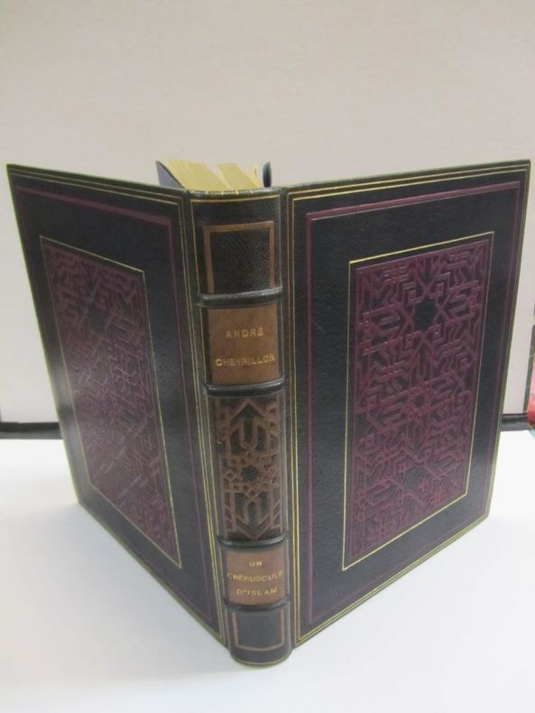
1930652441930 Chez l'Artiste, 1930, grand in 4° relié plein maroquin bleu nuit, dos à nerfs orné d'un décor géométrique "oriental" mosaïqué en maroquin violet, plats encadrés d'un double-filet doré accompagné d'un encadrement mosaïqué de maroquin violet, et au centre un grand décor géométrique "oriental" mosaïqué en maroquin violet encadré d'un filet doré, tête dorée, filet gras doré et encadrement mosaïqué en maroquin violet sur les contre-plats, doubles gardes de soie bleue et de papier marbré, étui (Mireille MAGNIN Relieur), 235 pages ; des rousseurs, essentiellement marginales ; dos très légèrement et uniformément passé ; menus défauts à l'étui.
2 vol. in-8, pp. XIX, 369; 404, leg. coeva cartone rosso, filetti e titolo impressi in oro al dorso. Prima ediz. definitiva della discussa opera del giurista sassarese Azuni (1749- 1826), uscita parzialmente nel 1798 sotto il titolo di "Essai sur l'histoire..". Il primo volume è dedicato al campo politico, sociale e amministrativo, mentre il secondo costituisce un completo trattato naturalistico sulla fauna terrestre e ittica, la flora e i minerali dell'isola; assai dettagliata, seppur non sostenuta da adeguate nozioni scientifiche. Una grande carta geogr. più volte ripieg. (cm 53x31), dis. e inc. da Perier, una tav. di monete e 7 belle tav. finem. inc. in rame da Tardieu l'ainé raffig. il muflone maschio e femmina, i rettili lanzinafenu e tiligugu, un grifone e la tonnara (2 tav.); da notare che il Piloni cita solo 5 tavole. "Le opere dell'A. non trovano immediata fortuna. L'A., che ha studiato a Sassari e che, caduto in disgrazia di Vittorio Amedeo III, trova l'appoggio di Napoleone, balza in primo piano per i suoi saggi fondamentali di dirritto marittimo più che per le sue pagine sull'isola, scritte con l'intento di offrire un quadro utile al miglioramento dei Sardi e duramente attaccate da alcuni contemporanei, che l'accusano di mancanza di ricerca, (Boscolo, Viaggiatori dell'Ottocento in S. p. 12). Magnifico esemplare in barbe, a fogli chiusi.. Ciasca 1034. Fossati Bellani 4146. Piloni, Sardegna nelle incisioni, 1783-1787 (solo 5 tav.). Piloni, Carte geogr. tav. LXXXIII..
Very Good Turkish, Ottoman (1500-1928) Original wrappers. Foolscap 8vo. (17 x 12 cm). In Ottoman script (Old Turkish with Arabic letters). 152 p. Roumi: 1324 = Gregorian: 1906. Taken from a volume including multiple books. Spine is restored. A very good copy. First and only edition of this early and extensively rare book including a first-hand account of the topography and descriptions of Hejaz, Mecca, and other parts of Arabian Peninsula such as Taif and Yemen by Sadiq Sherif, who was the first person to take photographs of Mecca, Medina, and the Hajj in 1880 and 1881 as well. Sadiq Sherif was the grandson of Serif Abdulmuttalib, the Emîr of Mecca. This book written by Sherif was dedicated to 'the Progress and Union Society' [i.e. Ittihad ve Terakki Cemiyeti]. The book describes the way of administration and territorial division of Hejaz after giving some information of its geography, borders, tribes and natives, mountains, rivers, crops and products, and animals of this Ottoman 'vilâyat' [i.e. province]. Sherif gives detailed information on how and when the Ottoman Empire ruled Hejaz, the location of Mecca city, its borders, physical and social geography, crops in Mecca and around, its flora, fauna, demographic structure, 'nahiyes', Kâba's construction, and its history, sacred places around, Masjid-i Haram and other masjids, cemeteries, mountains, gifts by Ottoman caliphs to Kaba, 'Taif' area, people who were 'Emîr' of Mecca from the period of Mohammad, Wahhabism and its birth, etc. At the last, Sherif gives place to his personal letter (layihâ) including 49 articles. The letter was about the reforms that Hejaz needs and it was sent to the Ottoman 'sadâret' [i.e. prime ministry]. (Source: History of geographical literature during the Ottoman Empire, Edited by Ihsanoglu). Muhammad Sadiq Sherif Bey was the first person to take photographs of Mecca, Medina, and the Hajj in 1880 and 1881. Sadiq Bey trained as a military engineer after completing his studies in Cairo and at the École Polytechnique in Paris. It is not known when, or from whom, Sadiq Bey learned to take photographs but it was most probably through one of the resident photographers in Egypt. In 1861, prompted by the need to carry out more extensive military land surveys of the area between Wajh and Medina, Sadiq Bey made his first journey to Arabia. He took a camera along with his surveying equipment and took his very first photographs of Medina. In a series of articles published in the Egyptian Military Gazette in 1877, he refers to his early photography at Medina describing the use of a 'photographia'. Sadly, however, none of the photographs from this first journey has survived. In 1880 he was appointed as the treasurer of the Mahmal, the ornate cloth to cover the Ka'ba brought each year on a special litter to Mecca. He accompanied the Mahmal to Medina and Mecca from September 1880 until January 1881. Again equipped with his camera, he succeeded in producing the series of photographs that are now considered some of the earliest known photographs of the region, those of the Ka'ba, taken under great secrecy. Sadiq Bey published various accounts of his travels in Arabia in military journals, through the Emiry Grand Press in Cairo, but the 1880/81 series of photographs appear to have been issued separately for wider distribution through the Société Khédiviale de Géographie. The society's secretary, Dr. Frederic Bonola, advertised sets of photographs for sale. In January and April 1880 Sadiq Bey gave a talk and report to the society on his earlier 1861 expedition, and on 20 May 1881 he presented a report on his recent journey to Mecca; detailed accounts were published in the society's bulletins, numbers 9/10 and 12. (Source: Christie's). Özege 11888.; Karatay, TM II: 695.; MKAHTBK, II: 991.; OCLC 248374684 / 4082352.
175560168London, A. Linde, 1755. Folio (370 x 225). Bound in a nice later half calf binding with six bands and gilt lettering to spine. Light miscoluring to spine otheriwse a very find and clean copy. XXIII, (1), 206, VII, (1), 291,(1) + Index (12) pp. + large folded hand coloured map and 28 engraved plates.
London, A. Linde, 1755. Folio (370 x 225). Bound in a nice later half calf binding with six bands and gilt lettering to spine. Light miscoluring to spine otheriwse a very find and clean copy. XXIII, (1), 206, VII, (1), 291,(1) + Index (12) pp. + large folded hand coloured map and 28 engraved plates.
200798430Valencia, Patrimonio Verlag 2007. 30 Seiten Faksimile mit kunstvoll goldgeschmückten Kartenwerke in einem ebenso opulenten wie fantasievollen Rahmen + 481 Seiten Kommentarband., Gr.-8°. Faksimile aus rotem rotem Leder mit vergoldeten Aufdrucken und Vollgoldschnitt., 8°. Kommentarband aus braunem illustrierten und vergoldeten Leinen mit einem illustrierten Schutzumschlag.,